2020 Indicators: SST's / SAL / MSLP / Steering / Shear / Instability / Sat Images

This is the general tropical discussion area. Anyone can take their shot at predicting a storms path.

Moderator: S2k Moderators

Forum rules

The posts in this forum are NOT official forecasts and should not be used as such. They are just the opinion of the poster and may or may not be backed by sound meteorological data. They are NOT endorsed by any professional institution or STORM2K. For official information, please refer to products from the National Hurricane Center and National Weather Service.

Help Support Storm2K
Message
Author
Shell Mound
Category 5
Category 5
Posts: 2434
Age: 32
Joined: Thu Sep 07, 2017 3:39 pm
Location: St. Petersburg, FL → Scandinavia

Re: 2020 Indicators: SST's / SAL / MSLP / Steering / Shear / Instability / Sat Images

#1101 Postby Shell Mound » Thu Jun 25, 2020 5:29 am

Shell Mound wrote:
JPmia wrote:
SFLcane wrote:
Yep...Let’s put this recurve discussion to bed now! This has been my concern to this point. Get ready folks :eek:


They're also mentioning that the high pressure pattern is a little further north than previous years...anyone get that? and if so, let's discuss what that could mean.

Looking at data for the IOD back to 1871, I found that most of the major hurricanes to hit (mainland) Southeast Florida coincided with a -IOD, including the big hits of 1888, 1926, 1928, 1933, 1945, 1947, 1950, 1965, and 1992. (If the Keys are included, then MH hits in 1929, 1935, and 1960 also occurred during -IOD events.) Only one MH hit—that of 1949—coincided with an +IOD. (If the Keys are included, then Irma in 2017 also coincided with an +IOD event.) According to the data, +IOD events during the peak of the Atlantic hurricane season have become much more frequent in the last twenty-five years than at any similar period since 1871. This may explain why we have seen fewer MH impacts on Southeast FL and the U.S. East Coast generally since the recent +AMO began in 1995. Based on ESRL 500-mb data, -IOD events tend to promote greater N-S (meridional) orientation of ridging, whereas +IOD events tend to facilitate E-W (zonal) “bridging” of ridging. In the latter situation, there tend to be more cutoff lows or TUTTs beneath the northward-displaced ridge, thereby inducing tracks either offshore or toward the Carolinas and/or Caribbean/GoM.

As an aside, does anyone know why the most recent CFSv2 runs have been depicting a relatively strong TUTT over the western MDR during ASO?

On another note:

 https://twitter.com/MJVentrice/status/1276114242551402499


 https://twitter.com/MJVentrice/status/1276114243746697219


 https://twitter.com/MJVentrice/status/1276114247739736064


 https://twitter.com/MJVentrice/status/1276114256040210435


 https://twitter.com/MJVentrice/status/1276114258116464642


0 likes   
CVW / MiamiensisWx / Shell Mound
The posts in this forum are NOT official forecasts and should not be used as such. They are just the opinion of the poster and may or may not be backed by sound meteorological data. They are NOT endorsed by any professional institution or STORM2K. For official information, please refer to products from the NHC and NWS.

TheStormExpert

Re: 2020 Indicators: SST's / SAL / MSLP / Steering / Shear / Instability / Sat Images

#1102 Postby TheStormExpert » Thu Jun 25, 2020 9:04 am

Shell Mound wrote:
Shell Mound wrote:
JPmia wrote:
They're also mentioning that the high pressure pattern is a little further north than previous years...anyone get that? and if so, let's discuss what that could mean.

Looking at data for the IOD back to 1871, I found that most of the major hurricanes to hit (mainland) Southeast Florida coincided with a -IOD, including the big hits of 1888, 1926, 1928, 1933, 1945, 1947, 1950, 1965, and 1992. (If the Keys are included, then MH hits in 1929, 1935, and 1960 also occurred during -IOD events.) Only one MH hit—that of 1949—coincided with an +IOD. (If the Keys are included, then Irma in 2017 also coincided with an +IOD event.) According to the data, +IOD events during the peak of the Atlantic hurricane season have become much more frequent in the last twenty-five years than at any similar period since 1871. This may explain why we have seen fewer MH impacts on Southeast FL and the U.S. East Coast generally since the recent +AMO began in 1995. Based on ESRL 500-mb data, -IOD events tend to promote greater N-S (meridional) orientation of ridging, whereas +IOD events tend to facilitate E-W (zonal) “bridging” of ridging. In the latter situation, there tend to be more cutoff lows or TUTTs beneath the northward-displaced ridge, thereby inducing tracks either offshore or toward the Carolinas and/or Caribbean/GoM.

As an aside, does anyone know why the most recent CFSv2 runs have been depicting a relatively strong TUTT over the western MDR during ASO?

On another note:

https://twitter.com/MJVentrice/status/1276114242551402499
https://twitter.com/MJVentrice/status/1276114243746697219
https://twitter.com/MJVentrice/status/1276114247739736064
https://twitter.com/MJVentrice/status/1276114256040210435
https://twitter.com/MJVentrice/status/1276114258116464642

I don’t see any TUTT’s in the Atlantic right now but that could always change. That also doesn’t mean the season will be dead, didn’t 2010 feature quite a few TUTT’s and look at its numbers.
0 likes   

User avatar
StruThiO
Category 3
Category 3
Posts: 821
Age: 25
Joined: Fri Sep 15, 2017 5:51 am
Location: Currently Portland, OR. Raised in Jax, FL.

Re: 2020 Indicators: SST's / SAL / MSLP / Steering / Shear / Instability / Sat Images

#1103 Postby StruThiO » Thu Jun 25, 2020 9:09 am

3 likes   

User avatar
FireRat
Category 5
Category 5
Posts: 1246
Age: 38
Joined: Sun Sep 26, 2010 11:38 pm
Location: North Carolina

Re: 2020 Indicators: SST's / SAL / MSLP / Steering / Shear / Instability / Sat Images

#1104 Postby FireRat » Thu Jun 25, 2020 10:30 am

It will be interesting to see how Imhotep (SAL) and King TUTT work their magic over the Atlantic during peak season! :cheesy:

TUTT helps recurve the storms out to sea very often, if I'm not mistaken. A lack of this would allow more storms to head westward. The season can be very active still, but 2010 is a good example in which most cape verde storms went OTS.
0 likes   
Georges '98, Irene '99, Frances '04, Jeanne '04, Katrina '05, Wilma '05, Gustav '08, Isaac '12, Matthew '16, Florence '18, Michael '18, Ian '22

User avatar
cycloneye
Admin
Admin
Posts: 145368
Age: 68
Joined: Thu Oct 10, 2002 10:54 am
Location: San Juan, Puerto Rico

Re: 2020 Indicators: SST's / SAL / MSLP / Steering / Shear / Instability / Sat Images

#1105 Postby cycloneye » Thu Jun 25, 2020 10:38 am

1 likes   
Visit the Caribbean-Central America Weather Thread where you can find at first post web cams,radars
and observations from Caribbean basin members Click Here

User avatar
gatorcane
S2K Supporter
S2K Supporter
Posts: 23691
Age: 47
Joined: Sun Mar 13, 2005 3:54 pm
Location: Boca Raton, FL

Re: 2020 Indicators: SST's / SAL / MSLP / Steering / Shear / Instability / Sat Images

#1106 Postby gatorcane » Thu Jun 25, 2020 11:48 am

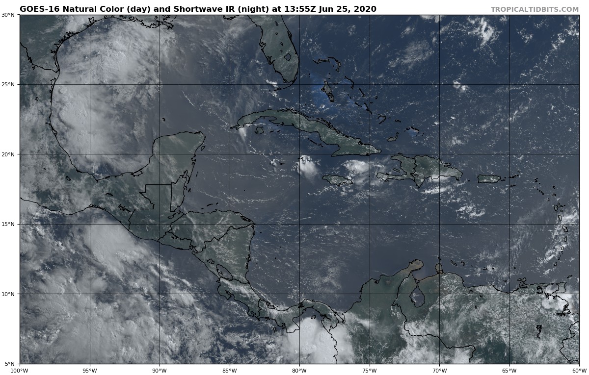
This record-breaking SAL surge is passing by Florida and the Bahamas to the south and heading WNW into the GOM. Wonder if this is an early indicator of some storm tracks later this season? “Caribbean runners” would be what we call them. Nice 700MB ridge protecting Florida and the Bahamas clearly seen here:

Image
Last edited by gatorcane on Thu Jun 25, 2020 11:50 am, edited 1 time in total.
0 likes   

User avatar
toad strangler
S2K Supporter
S2K Supporter
Posts: 4543
Joined: Sun Jul 28, 2013 3:09 pm
Location: Earth
Contact:

Re: 2020 Indicators: SST's / SAL / MSLP / Steering / Shear / Instability / Sat Images

#1107 Postby toad strangler » Thu Jun 25, 2020 11:49 am

gatorcane wrote:This record-breaking SAL surge is passing by Florida and the Bahamas to the south and heading WNW into the GOM. Wonder if this is an early indicator of some storm tracks later this season? “Caribbean runners” would be what we call them:

https://i.postimg.cc/HxJ7nT8M/goes16-truecolor-watl-202006251355.jpg


I call 'em Caribbean Cruisers and not sure if that's a viable signal for later in the season or not. Many times FL got a good shot of SAL early which meant nothing track wise come A/S/O. It's an interesting thought though.
1 likes   

Shell Mound
Category 5
Category 5
Posts: 2434
Age: 32
Joined: Thu Sep 07, 2017 3:39 pm
Location: St. Petersburg, FL → Scandinavia

Re: 2020 Indicators: SST's / SAL / MSLP / Steering / Shear / Instability / Sat Images

#1108 Postby Shell Mound » Thu Jun 25, 2020 12:43 pm

TheStormExpert wrote:
Shell Mound wrote:
Shell Mound wrote:Looking at data for the IOD back to 1871, I found that most of the major hurricanes to hit (mainland) Southeast Florida coincided with a -IOD, including the big hits of 1888, 1926, 1928, 1933, 1945, 1947, 1950, 1965, and 1992. (If the Keys are included, then MH hits in 1929, 1935, and 1960 also occurred during -IOD events.) Only one MH hit—that of 1949—coincided with an +IOD. (If the Keys are included, then Irma in 2017 also coincided with an +IOD event.) According to the data, +IOD events during the peak of the Atlantic hurricane season have become much more frequent in the last twenty-five years than at any similar period since 1871. This may explain why we have seen fewer MH impacts on Southeast FL and the U.S. East Coast generally since the recent +AMO began in 1995. Based on ESRL 500-mb data, -IOD events tend to promote greater N-S (meridional) orientation of ridging, whereas +IOD events tend to facilitate E-W (zonal) “bridging” of ridging. In the latter situation, there tend to be more cutoff lows or TUTTs beneath the northward-displaced ridge, thereby inducing tracks either offshore or toward the Carolinas and/or Caribbean/GoM.

As an aside, does anyone know why the most recent CFSv2 runs have been depicting a relatively strong TUTT over the western MDR during ASO?

On another note:

https://twitter.com/MJVentrice/status/1276114242551402499
https://twitter.com/MJVentrice/status/1276114243746697219
https://twitter.com/MJVentrice/status/1276114247739736064
https://twitter.com/MJVentrice/status/1276114256040210435
https://twitter.com/MJVentrice/status/1276114258116464642

I don’t see any TUTT’s in the Atlantic right now but that could always change. That also doesn’t mean the season will be dead, didn’t 2010 feature quite a few TUTT’s and look at its numbers.

I was referring to monthly CFSv2 climate forecasts for 250-850-mb vertical wind shear in the Atlantic basin during ASO (peak season), not currently.
FireRat wrote:It will be interesting to see how Imhotep (SAL) and King TUTT work their magic over the Atlantic during peak season! :cheesy:

TUTT helps recurve the storms out to sea very often, if I'm not mistaken. A lack of this would allow more storms to head westward. The season can be very active still, but 2010 is a good example in which most cape verde storms went OTS.

Yes, you are correct. One important factor to watch is the orientation and placement of the Bermuda High in ASO. Even if the ridge is quite strong, if it is displaced too far to the north, then there will be TUTTs retrograding beneath the ridge that could allow storms to miss the U.S. East Coast, especially if the ridge is zonally oriented E-W rather than N-S, meaning less “blockiness” than, say, a Sandy- or 1926-type ridge. Currently the CFSv2, UKMET, and occasionally ECMWF have been rather consistently hinting that the Bermuda High will be both strong and displaced well to the north of its typical location. That is why the precipitation maps show a sharp turn to the north over/near the Bahamas and just off the Southeastern U.S. If that ridge were modelled farther south, the precipitation would extend farther inland over FL and the interior Southeastern U.S./coastal plain (including the Gulf Coast). In order for the U.S. to be at greater risk than is currently forecast, the models would need to shift the Bermuda High farther south than it has been currently forecast to be in ASO. If that doesn’t happen, then we could see a 2010-type season with a lot of OTS storms and/or “Caribbean cruisers” that stay well to the south of the U.S. mainland.

 https://twitter.com/webberweather/status/1275801516079808513


Note that the ridge has been rather far to the north thus far in 2020, so storms could slip OTS between the U.S. and Bermuda, owing to flatness of ridge.
Last edited by Shell Mound on Thu Jun 25, 2020 1:05 pm, edited 3 times in total.
0 likes   
CVW / MiamiensisWx / Shell Mound
The posts in this forum are NOT official forecasts and should not be used as such. They are just the opinion of the poster and may or may not be backed by sound meteorological data. They are NOT endorsed by any professional institution or STORM2K. For official information, please refer to products from the NHC and NWS.

tolakram
Admin
Admin
Posts: 20010
Age: 62
Joined: Sun Aug 27, 2006 8:23 pm
Location: Florence, KY (name is Mark)

Re: 2020 Indicators: SST's / SAL / MSLP / Steering / Shear / Instability / Sat Images

#1109 Postby tolakram » Thu Jun 25, 2020 12:44 pm

From a few years back. If anyone forgets the TUTT and how fast things can change.

 https://twitter.com/MJVentrice/status/903315637241556992


4 likes   
M a r k
- - - - -
Join us in chat: Storm2K Chatroom Invite. Android and IOS apps also available.

The posts in this forum are NOT official forecasts and should not be used as such. Posts are NOT endorsed by any professional institution or STORM2K.org. For official information and forecasts, please refer to NHC and NWS products.

tolakram
Admin
Admin
Posts: 20010
Age: 62
Joined: Sun Aug 27, 2006 8:23 pm
Location: Florence, KY (name is Mark)

Re: 2020 Indicators: SST's / SAL / MSLP / Steering / Shear / Instability / Sat Images

#1110 Postby tolakram » Thu Jun 25, 2020 12:49 pm

July is a lot different from Aug / Sept though and I do think July will be more on the quiet side, but it's very hard to tell at this point, IMO.
4 likes   
M a r k
- - - - -
Join us in chat: Storm2K Chatroom Invite. Android and IOS apps also available.

The posts in this forum are NOT official forecasts and should not be used as such. Posts are NOT endorsed by any professional institution or STORM2K.org. For official information and forecasts, please refer to NHC and NWS products.

User avatar
toad strangler
S2K Supporter
S2K Supporter
Posts: 4543
Joined: Sun Jul 28, 2013 3:09 pm
Location: Earth
Contact:

Re: 2020 Indicators: SST's / SAL / MSLP / Steering / Shear / Instability / Sat Images

#1111 Postby toad strangler » Thu Jun 25, 2020 2:11 pm

tolakram wrote:From a few years back. If anyone forgets the TUTT and how fast things can change.

https://twitter.com/MJVentrice/status/903315637241556992?s=20


I believe that a storm moving through with a TUTT to its NE will be aided by said TUTT. Isn't that what happened with Irma?
1 likes   

Shell Mound
Category 5
Category 5
Posts: 2434
Age: 32
Joined: Thu Sep 07, 2017 3:39 pm
Location: St. Petersburg, FL → Scandinavia

Re: 2020 Indicators: SST's / SAL / MSLP / Steering / Shear / Instability / Sat Images

#1112 Postby Shell Mound » Thu Jun 25, 2020 2:42 pm

Image

This doesn’t really look like a favourable pattern for an active Atlantic season. It’s more similar to that of years with weak El Niño conditions.

Image

Note that the ridge is displaced well to the north of its typical location, so precipitation tends to curve just off the Southeastern U.S.:

Image

TC activity clearly does not penetrate very far inland from the immediate coastline, owing to the displacement of the ridge.
Last edited by Shell Mound on Thu Jun 25, 2020 2:44 pm, edited 1 time in total.
0 likes   
CVW / MiamiensisWx / Shell Mound
The posts in this forum are NOT official forecasts and should not be used as such. They are just the opinion of the poster and may or may not be backed by sound meteorological data. They are NOT endorsed by any professional institution or STORM2K. For official information, please refer to products from the NHC and NWS.

User avatar
CyclonicFury
Category 5
Category 5
Posts: 2025
Age: 26
Joined: Sun Jul 02, 2017 12:32 pm
Location: NC
Contact:

Re: 2020 Indicators: SST's / SAL / MSLP / Steering / Shear / Instability / Sat Images

#1113 Postby CyclonicFury » Thu Jun 25, 2020 2:43 pm

Shell Mound wrote:https://www.tropicaltidbits.com/analysis/models/cfs-mon/2020062506/cfs-mon_01_ashearMean_month_atl_2.png

This doesn’t really look like a favourable pattern for an active Atlantic season. It’s more similar to that of years with weak El Niño conditions.

A few days ago it wasn't showing that. Also, shear is below normal in the Caribbean, not quite El Niño like.
4 likes   
NCSU B.S. in Meteorology Class of 2021. Tropical weather blogger at http://www.cyclonicfury.com. My forecasts and thoughts are NOT official, for official forecasts please consult the National Hurricane Center.

AutoPenalti
Category 5
Category 5
Posts: 4030
Age: 29
Joined: Mon Aug 17, 2015 4:16 pm
Location: Ft. Lauderdale, Florida

Re: 2020 Indicators: SST's / SAL / MSLP / Steering / Shear / Instability / Sat Images

#1114 Postby AutoPenalti » Thu Jun 25, 2020 2:48 pm

Please don't use CFS for predicting future tracks.
1 likes   
The posts in this forum are NOT official forecasts and should not be used as such. They are just the opinion of the poster and may or may not be backed by sound meteorological data. They are NOT endorsed by any professional institution or STORM2K. For official information, please refer to products from the NHC and NWS.


Model Runs Cheat Sheet:
GFS (5:30 AM/PM, 11:30 AM/PM)
HWRF, GFDL, UKMET, NAVGEM (6:30-8:00 AM/PM, 12:30-2:00 AM/PM)
ECMWF (1:45 AM/PM)

TCVN
is a weighted averaged

Shell Mound
Category 5
Category 5
Posts: 2434
Age: 32
Joined: Thu Sep 07, 2017 3:39 pm
Location: St. Petersburg, FL → Scandinavia

Re: 2020 Indicators: SST's / SAL / MSLP / Steering / Shear / Instability / Sat Images

#1115 Postby Shell Mound » Thu Jun 25, 2020 2:51 pm

CyclonicFury wrote:
Shell Mound wrote:https://www.tropicaltidbits.com/analysis/models/cfs-mon/2020062506/cfs-mon_01_ashearMean_month_atl_2.png

This doesn’t really look like a favourable pattern for an active Atlantic season. It’s more similar to that of years with weak El Niño conditions.

A few days ago it wasn't showing that. Also, shear is below normal in the Caribbean, not quite El Niño like.

Why do you think the most recent runs have shifted toward a much stronger TUTT over the MDR? Regarding tracks, the CFSv2 has been quite consistent, along with the UKMET and ECMWF, in suggesting that the highest precipitation stays just offshore of the Southeastern U.S. during ASO. As I mentioned, the ridge, while quite strong, is consistently forecast by the major global models to be displaced too far to the north, allowing TUTT-related weaknesses underneath that allow prospective storms to curve just east of the Southeastern U.S., so the precipitation bands do not penetrate very far inland from the immediate coastline. The long-range dynamical models have been very consistent about this over the past month or so. What could cause this to change?
AutoPenalti wrote:Please don't use CFS for predicting future tracks.

The UKMET and ECMWF have been showing similar precipitation patterns over the past several runs.
0 likes   
CVW / MiamiensisWx / Shell Mound
The posts in this forum are NOT official forecasts and should not be used as such. They are just the opinion of the poster and may or may not be backed by sound meteorological data. They are NOT endorsed by any professional institution or STORM2K. For official information, please refer to products from the NHC and NWS.

AutoPenalti
Category 5
Category 5
Posts: 4030
Age: 29
Joined: Mon Aug 17, 2015 4:16 pm
Location: Ft. Lauderdale, Florida

Re: 2020 Indicators: SST's / SAL / MSLP / Steering / Shear / Instability / Sat Images

#1116 Postby AutoPenalti » Thu Jun 25, 2020 2:55 pm

Shell Mound wrote:
CyclonicFury wrote:
Shell Mound wrote:https://www.tropicaltidbits.com/analysis/models/cfs-mon/2020062506/cfs-mon_01_ashearMean_month_atl_2.png

This doesn’t really look like a favourable pattern for an active Atlantic season. It’s more similar to that of years with weak El Niño conditions.

A few days ago it wasn't showing that. Also, shear is below normal in the Caribbean, not quite El Niño like.

Why do you think the most recent runs have shifted toward a much stronger TUTT over the MDR? Regarding tracks, the CFSv2 has been quite consistent, along with the UKMET and ECMWF, in suggesting that the highest precipitation stays just offshore of the Southeastern U.S. during ASO. As I mentioned, the ridge, while quite strong, is consistently forecast by the major global models to be displaced too far to the north, allowing TUTT-related weaknesses underneath that allow prospective storms to curve just east of the Southeastern U.S., so the precipitation bands do not penetrate very far inland from the immediate coastline. The long-range dynamical models have been very consistent about this over the past month or so. What could cause this to change?
AutoPenalti wrote:Please don't use CFS for predicting future tracks.

The UKMET and ECMWF have been showing similar precipitation patterns over the past several runs.

Precipitation patterns don't equate to potential tracks from what I understand.
0 likes   
The posts in this forum are NOT official forecasts and should not be used as such. They are just the opinion of the poster and may or may not be backed by sound meteorological data. They are NOT endorsed by any professional institution or STORM2K. For official information, please refer to products from the NHC and NWS.


Model Runs Cheat Sheet:
GFS (5:30 AM/PM, 11:30 AM/PM)
HWRF, GFDL, UKMET, NAVGEM (6:30-8:00 AM/PM, 12:30-2:00 AM/PM)
ECMWF (1:45 AM/PM)

TCVN
is a weighted averaged

User avatar
MississippiWx
S2K Supporter
S2K Supporter
Posts: 1699
Joined: Sat Aug 14, 2010 1:44 pm
Location: Hattiesburg, Mississippi

Re: 2020 Indicators: SST's / SAL / MSLP / Steering / Shear / Instability / Sat Images

#1117 Postby MississippiWx » Thu Jun 25, 2020 2:55 pm

The CFS model is hardly a good source of prediction.

Anyway, when the EPac struggles to produce tropical cyclones, you know it’s game on for the Atlantic. The EPac had four invests this week and only one has been able to develop into a struggling tropical depression. The Atlantic was able to spit out a tropical storm at 40N. The signs are screaming for a very active Atlantic.
9 likes   
This post is not an official forecast and should not be used as such. It is just the opinion of MississippiWx and may or may not be backed by sound meteorological data. It is not endorsed by any professional institution including storm2k.org. For Official Information please refer to the NHC and NWS products.

User avatar
Kingarabian
S2K Supporter
S2K Supporter
Posts: 15981
Joined: Sat Aug 08, 2009 3:06 am
Location: Honolulu, Hawaii

Re: 2020 Indicators: SST's / SAL / MSLP / Steering / Shear / Instability / Sat Images

#1118 Postby Kingarabian » Thu Jun 25, 2020 3:10 pm

MississippiWx wrote:The CFS model is hardly a good source of prediction.

Anyway, when the EPac struggles to produce tropical cyclones, you know it’s game on for the Atlantic. The EPac had four invests this week and only one has been able to develop into a struggling tropical depression. The Atlantic was able to spit out a tropical storm at 40N. The signs are screaming for a very active Atlantic.

We still need to wait it out for another week or so before we can make a determination that the EPAC will or will not be an inhibiting factor this season (some invests discussed in the EPAC thread need time). But it surely is starting to look like the EPAC will not be standing in the Atlantic's way this season.
4 likes   
RIP Kobe Bryant

User avatar
cycloneye
Admin
Admin
Posts: 145368
Age: 68
Joined: Thu Oct 10, 2002 10:54 am
Location: San Juan, Puerto Rico

Re: 2020 Indicators: SST's / SAL / MSLP / Steering / Shear / Instability / Sat Images

#1119 Postby cycloneye » Thu Jun 25, 2020 3:56 pm

MississippiWx wrote:The CFS model is hardly a good source of prediction.

Anyway, when the EPac struggles to produce tropical cyclones, you know it’s game on for the Atlantic. The EPac had four invests this week and only one has been able to develop into a struggling tropical depression. The Atlantic was able to spit out a tropical storm at 40N. The signs are screaming for a very active Atlantic.


Is now TS Boris but only will last at much 12 hours or less.The EPAC so far is not producing.
0 likes   
Visit the Caribbean-Central America Weather Thread where you can find at first post web cams,radars
and observations from Caribbean basin members Click Here


Return to “Talkin' Tropics”

Who is online

Users browsing this forum: dl20415, Ulf and 51 guests