Low pressure developing over the western Caribbean Sea (Is Invest 97L)
Moderator: S2k Moderators
Forum rules

The posts in this forum are NOT official forecasts and should not be used as such. They are just the opinion of the poster and may or may not be backed by sound meteorological data. They are NOT endorsed by any professional institution or STORM2K. For official information, please refer to products from the National Hurricane Center and National Weather Service.
-
Ivanhater

- Storm2k Moderator

- Posts: 11222
- Age: 39
- Joined: Fri Jul 01, 2005 8:25 am
- Location: Pensacola
Re: Area of low pressure to develop over the western Caribbean sea (10/70)
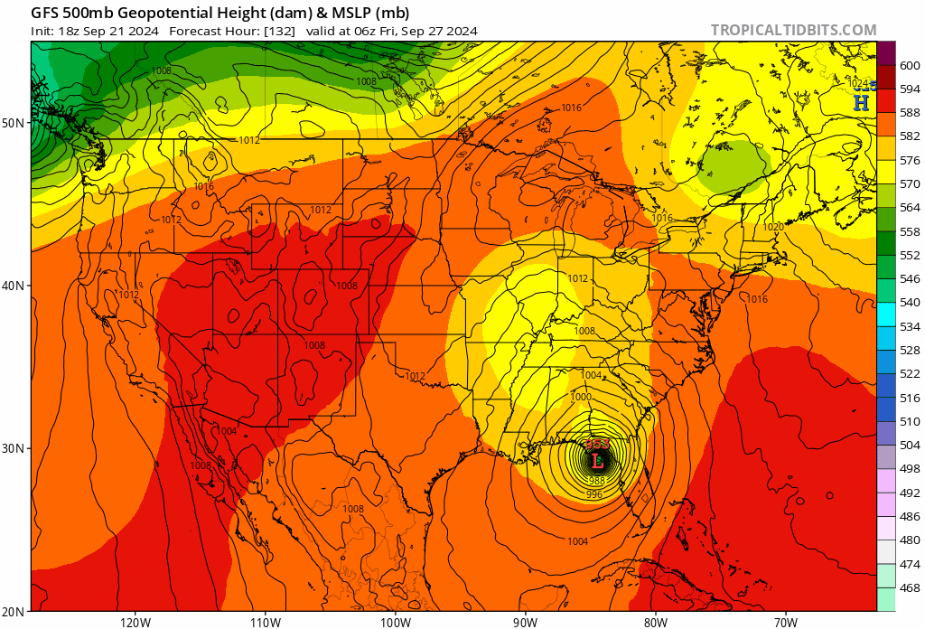
Yes, both GFS and Euro ensembles showing the trough cutting off and swinging north west I stead of progressing NE. This will keep northwest Florida and point west more in danger. Let's see if the afternoon models continue this idea
4 likes
Michael
Re: Area of low pressure to develop over the western Caribbean sea (10/70)
One data point I like to keep tabs on is WPC's 7 day QPF. As of now the heavy precip is east of Mobile with not much west of there.
1 likes
-
Blown Away

- S2K Supporter

- Posts: 10253
- Joined: Wed May 26, 2004 6:17 am
Re: Area of low pressure to develop over the western Caribbean sea (10/70)
Steve wrote:Yeah so GFS is relatively similar to ICON at 6z though it has the cutoff dropping toward Dallas. Notice how (hit play obviously) after landfall the hurricane goes due north through Alabama and then hooks left toward Memphis before merging.
https://www.tropicaltidbits.com/analysi ... 206&fh=120
Agree Steve, there is very fine line there and models have been going back n forth with these 2 solutions. IMO it’s how far N and W along with intensity are AOI gets before leaving Caribbean will determine the 2 solutions you are discussing.
1 likes
Hurricane Eye Experience: David 79, Irene 99, Frances 04, Jeanne 04, Wilma 05… Hurricane Brush Experience: Andrew 92, Erin 95, Floyd 99, Matthew 16, Irma 17, Ian 22, Nicole 22…
-
Weathertracker96
- Tropical Storm

- Posts: 150
- Joined: Mon Oct 16, 2023 3:41 pm
Re: Area of low pressure to develop over the western Caribbean sea (10/70)
The 06z Euro-AI is still east in the big bend.
Does anyone think missions may start soon to sample the air?
That may help with the models
Does anyone think missions may start soon to sample the air?
That may help with the models
1 likes

Re: Area of low pressure to develop over the western Caribbean sea (10/70)
Absolutely. I needed to go to my house in Pensacola on Thursday so I was hoping for delayed development or a more eastern solution without wishing anything bad on anyone. I imagine I’ll be staring at CONUS water vapor loops to watch the evolution of the trough and whether a piece of the NE trough can otherwise break through and grab it.
Definitely still have both scenarios on the table here with impacts divvied up accordingly.
Definitely still have both scenarios on the table here with impacts divvied up accordingly.
2 likes
-
Stormlover70
- Tropical Storm
- Posts: 194
- Age: 56
- Joined: Fri Jun 21, 2024 5:31 am
- Location: New port richey
Re: Area of low pressure to develop over the western Caribbean sea (10/70)
Hopefully it's not another Ivan if that's the case.Ivanhater wrote:Yes, both GFS and Euro ensembles showing the trough cutting off and swinging north west I stead of progressing NE. This will keep northwest Florida and point west more in danger. Let's see if the afternoon models continue this idea
3 likes
Re: Area of low pressure to develop over the western Caribbean sea (10/70)
Next hints will come from NAM 12km and 3km 500 geopotential heights + MSLP. Those are less than halfway done so it’s gonna be another 20
Minutes or so.
Minutes or so.
1 likes
Re: Area of low pressure to develop over the western Caribbean sea (10/70)
Stormlover70 wrote:Hopefully it's not another Ivan if that's the case.Ivanhater wrote:Yes, both GFS and Euro ensembles showing the trough cutting off and swinging north west I stead of progressing NE. This will keep northwest Florida and point west more in danger. Let's see if the afternoon models continue this idea
Haha. It goes without saying that Ivanhater would not like that. And damn. It’s been 20 years now.
4 likes
-
Hypercane_Kyle

- Category 5

- Posts: 3465
- Joined: Sat Mar 07, 2015 7:58 pm
- Location: Cape Canaveral, FL
Re: Low pressure developing over the western Caribbean Sea (10/70)
Last three runs of the EC-AIFS model have been remarkably consistent on a solution up near Perry, FL on Thursday night.
Going to be a wild week.
Going to be a wild week.
4 likes
My posts are my own personal opinion, defer to the National Hurricane Center (NHC) and other NOAA products for decision making during hurricane season.
-
TreasureIslandFLGal

- S2K Supporter
- Posts: 1584
- Age: 58
- Joined: Sun Aug 15, 2004 6:16 pm
- Location: Cancun, Mexico (northeast Yucatan coast)
Re: Area of low pressure to develop over the western Caribbean sea (10/70)
Ugh! Why is it that whenever there is a developing storm that has the possibility of impacting Tampa Bay that I have big projects or proposals to get done?! I am way more interested in watching every model's solution evolution and the related chat here than anything related to work.  I was already procrastinating all of the tasks that I've needed to do by Monday morning, but gee whiz, with a developing gulf storm, the tedious job ahead has become that much more boring and miserable to have to do!
5 likes
Chrissy & Ligeia

-
Ivanhater
- Storm2k Moderator
- Posts: 11222
- Age: 39
- Joined: Fri Jul 01, 2005 8:25 am
- Location: Pensacola
Re: Area of low pressure to develop over the western Caribbean sea (10/70)
Steve wrote:Stormlover70 wrote:Hopefully it's not another Ivan if that's the case.Ivanhater wrote:Yes, both GFS and Euro ensembles showing the trough cutting off and swinging north west I stead of progressing NE. This will keep northwest Florida and point west more in danger. Let's see if the afternoon models continue this idea
Haha. It goes without saying that Ivanhater would not like that. And damn. It’s been 20 years now.
Haaa, this will be no Ivan but could be pretty nasty for someone.
Good to see you here Steve, you are offering some killer analysis like always
5 likes
Michael
Re: Low pressure developing over the western Caribbean Sea (10/70)
Maybe she could just slide in between the Florida Keys and Cuba through the Florida straits and leave us be. 
3 likes
-
Stormlover70
- Tropical Storm
- Posts: 194
- Age: 56
- Joined: Fri Jun 21, 2024 5:31 am
- Location: New port richey
Re: Area of low pressure to develop over the western Caribbean sea (10/70)
Intensity is hard to forecast but this should be interactive with the front which could extrapolate winds.Ivanhater wrote:Steve wrote:Stormlover70 wrote:Hopefully it's not another Ivan if that's the case.
Haha. It goes without saying that Ivanhater would not like that. And damn. It’s been 20 years now.
Haaa, this will be no Ivan but could be pretty nasty for someone.
Good to see you here Steve, you are offering some killer analysis like always
1 likes

Re: Area of low pressure to develop over the western Caribbean sea (10/70)
sponger wrote:Any severe hit on Florida will accelerate the insurance crisis and real estate collapse. My insurance was 800 a year three years ago. It is 2700 now with estimates of heading to 7-10K per year. We are in big big trouble!
After Ian we needed a new roof which insurance paid. Then I had a 3rd nail job done (1973 ranch, only 2 nails on the straps). After that we received a $10K state home-hardening grant from My Florida Safe Home and installed impact windows. My agent ran the all updates, $2400, I was like ok nice. Then at renewal $3400
7 likes
Elena '85 - Charley '04 - Wilma '05 - Irma '17 - Ian '22
-
Beer Belly
- Tropical Low

- Posts: 15
- Joined: Tue Sep 27, 2022 8:57 pm
Re: Area of low pressure to develop over the western Caribbean sea (10/70)
beachnut wrote:sponger wrote:Any severe hit on Florida will accelerate the insurance crisis and real estate collapse. My insurance was 800 a year three years ago. It is 2700 now with estimates of heading to 7-10K per year. We are in big big trouble!
After Ian we needed a new roof which insurance paid. Then I had a 3rd nail job done (1973 ranch, only 2 nails on the straps). After that we received a $10K state home-hardening grant from My Florida Safe Home and installed impact windows. My agent ran the all updates, $2400, I was like ok nice. Then at renewal $3400
HOA costs as well. I just got special assessed for $13,400 due to residual damage from Sally and who knows what insurance rates are going to do next year. We can’t be political here so I’ll simply say I wish our state government would more prioritize costs of being a homeowner in Florida. Many of our residents are retirees on fixed incomes. It’s already happened in Louisiana. Almost everyone I know with even modest houses is paying more for escrow than P&I. Homeowners rates, when you can even get someone to offer coverage, are nuts.
——————
NAM 12km @ 3z Wednesday am (10pm Tuesday) has not yet split the trough but it looks close. Assuming landfall Thursday, if this is going to cut off it’s going to be within 48 hours of landfall. If all models go to that solution we should be able to bank it. But not yet. Hurry up Nam and run
https://www.tropicaltidbits.com/analysi ... 2212&fh=63
4 likes
Re: Low pressure developing over the western Caribbean Sea (10/70)
Beer Belly wrote:Any strength models?
Those start coming out after designation.
0 likes
Re: Low pressure developing over the western Caribbean Sea (10/70)
Here we go - NAM 12km 12z 78 hours has the cutoff low. Low cuts off early morning hours Wednesday so I was being impatient. It has it in a similar place as the ICON 06z OK/AR border and a little south of the 06 GFS. The 12z is running now.
If this holds, look for the idea of a mobile to Destin (give or take) landfall becoming more likely.
https://www.tropicaltidbits.com/analysi ... 2212&fh=78
If this holds, look for the idea of a mobile to Destin (give or take) landfall becoming more likely.
https://www.tropicaltidbits.com/analysi ... 2212&fh=78
Last edited by Steve on Sun Sep 22, 2024 9:51 am, edited 1 time in total.
1 likes
-
StPeteMike

- Category 2

- Posts: 657
- Joined: Thu Jun 07, 2018 11:26 pm
Re: Area of low pressure to develop over the western Caribbean sea (10/70)
Steve wrote:beachnut wrote:sponger wrote:Any severe hit on Florida will accelerate the insurance crisis and real estate collapse. My insurance was 800 a year three years ago. It is 2700 now with estimates of heading to 7-10K per year. We are in big big trouble!
After Ian we needed a new roof which insurance paid. Then I had a 3rd nail job done (1973 ranch, only 2 nails on the straps). After that we received a $10K state home-hardening grant from My Florida Safe Home and installed impact windows. My agent ran the all updates, $2400, I was like ok nice. Then at renewal $3400
HOA costs as well. I just got special assessed for $13,400 due to residual damage from Sally and who knows what insurance rates are going to do next year. We can’t be political here so I’ll simply say I wish our state government would more prioritize costs of being a homeowner in Florida. Many of our residents are retirees on fixed incomes. It’s already happened in Louisiana. Almost everyone I know with even modest houses is paying more for escrow than P&I. Homeowners rates, when you can even get someone to offer coverage, are nuts.
——————
NAM 12km @ 3z Wednesday am (10pm Tuesday) has not yet split the trough but it looks close. Assuming landfall Thursday, if this is going to cut off it’s going to be within 48 hours of landfall. If all models go to that solution we should be able to bank it. But not yet. Hurry up Nam and run
https://www.tropicaltidbits.com/analysi ... 2212&fh=63
975 while still in the Caribbean though?!?

1 likes
The above post is not official and should not be used as such. It is the opinion of the poster and may or may not be backed by sound meteorological data. It is not endorsed by any professional institution or storm2k.org. For official information, please refer to the NHC and NWS products.
-
DunedinDave
- Category 1

- Posts: 269
- Joined: Fri Aug 25, 2023 10:31 am
Re: Low pressure developing over the western Caribbean Sea (10/70)
Steve wrote:Here we go - NAM 12km 12z 78 hours has the cutoff low. Low cuts off early morning hours Wednesday so I was being impatient. It has it in a similar place as the ICON 06z OK/AR border and a little south of the 06 GFS. The 12z is running now.
If this holds, look for the mobile to Destin (give or take) landfall becoming more likely.
https://www.tropicaltidbits.com/analysi ... 2212&fh=78
That’s good news for us in Tampa Bay area. *breathing sigh of relief*
3 likes
Who is online
Users browsing this forum: No registered users and 200 guests