
http://adds.aviationweather.gov/satelli ... itype=irbw
looks like a decent low pressure at least now
EAST COAST DEVELOPMENT
Moderator: S2k Moderators
Forum rules

The posts in this forum are NOT official forecasts and should not be used as such. They are just the opinion of the poster and may or may not be backed by sound meteorological data. They are NOT endorsed by any professional institution or STORM2K. For official information, please refer to products from the National Hurricane Center and National Weather Service.
Re: EAST COAST DEVELOPMENT
0 likes


Re: EAST COAST DEVELOPMENT
My opinion and a buck fifty will get you a soda, but I think that this thing might be a hybrid low. At the very least its going to bring TS/gale force gusts from northern NC to at least New Jersey.
0 likes
-
Brent
- S2K Supporter

- Posts: 38487
- Age: 37
- Joined: Sun May 16, 2004 10:30 pm
- Location: Tulsa Oklahoma
- Contact:
Re: EAST COAST DEVELOPMENT
SPECIAL TROPICAL WEATHER OUTLOOK
NWS TPC/NATIONAL HURRICANE CENTER MIAMI FL
1045 PM EDT THU SEP 10 2009
FOR THE NORTH ATLANTIC...CARIBBEAN SEA AND THE GULF OF MEXICO...
SPECIAL OUTLOOK ISSUED TO INCLUDE DISCUSSION OF LOW PRESSURE AREA
JUST EAST THE MID-ATLANTIC COAST.
THE NATIONAL HURRICANE CENTER IS ISSUING ADVISORIES ON HURRICANE
FRED...LOCATED ABOUT 740 MILES WEST OF THE CAPE VERDE ISLANDS.
UPDATED...SHOWER AND THUNDERSTORM ACTIVITY HAS INCREASED IN
ASSOCIATION WITH A NON-TROPICAL AREA OF LOW PRESSURE LOCATED JUST
EAST OF THE MID-ATLANTIC COAST. THIS SYSTEM REMAINS ASSOCIATED
WITH A FRONTAL BOUNDARY AND AN UPPER-LEVEL LOW...AND DEVELOPMENT
INTO A TROPICAL OR SUBTROPICAL CYCLONE IS NOT EXPECTED DUE TO
UNFAVORABLE UPPER-LEVEL WINDS. THERE IS A LOW CHANCE...LESS THAN 30
PERCENT...OF THIS SYSTEM BECOMING A TROPICAL OR SUBTROPICAL CYCLONE
DURING THE NEXT 48 HOURS. HEAVY RAIN...GUSTY WINDS...AND MINOR
COASTAL FLOODING ARE POSSIBLE ALONG PORTIONS OF THE MID-ATLANTIC
COAST OVER THE NEXT DAY OR SO. FOR ADDITIONAL INFORMATION...PLEASE
REFER TO PRODUCTS ISSUED BY LOCAL NATIONAL WEATHER SERVICE OFFICES
IN THE REGION AND HIGH SEAS FORECASTS ISSUED BY THE NATIONAL
WEATHER SERVICE...UNDER AWIPS HEADER NFDHSFAT1 AND WMO HEADER
FZNT01 KWBC.
WIDESPREAD SHOWERS AND THUNDERSTORMS OVER THE NORTHWESTERN GULF OF
MEXICO ARE ASSOCIATED WITH A SURFACE TROUGH INTERACTING WITH A MID-
TO UPPER-LEVEL LOW. UPPER-LEVEL WINDS ARE EXPECTED TO REMAIN
UNFAVORABLE FOR DEVELOPMENT OF THIS SYSTEM AS IT REMAINS NEARLY
STATIONARY NEAR THE TEXAS COAST DURING THE NEXT COUPLE OF DAYS.
THERE IS A LOW CHANCE...LESS THAN 30 PERCENT...OF THIS SYSTEM
BECOMING A TROPICAL CYCLONE DURING THE NEXT 48 HOURS. REGARDLESS OF
DEVELOPMENT...LOCALLY HEAVY RAINFALL IS POSSIBLE ALONG THE GULF
COAST FROM NORTHEASTERN MEXICO TO LOUISIANA OVER THE NEXT DAY OR
TWO.
ELSEWHERE...TROPICAL CYCLONE FORMATION IS NOT EXPECTED DURING THE
NEXT 48 HOURS.
$$
FORECASTER BERG
0 likes


-
HURAKAN

- Professional-Met

- Posts: 46086
- Age: 38
- Joined: Thu May 20, 2004 4:34 pm
- Location: Key West, FL
- Contact:
Re: EAST COAST DEVELOPMENT
613
ABNT20 KNHC 111152
TWOAT
TROPICAL WEATHER OUTLOOK
NWS TPC/NATIONAL HURRICANE CENTER MIAMI FL
800 AM EDT FRI SEP 11 2009
FOR THE NORTH ATLANTIC...CARIBBEAN SEA AND THE GULF OF MEXICO...
THE NATIONAL HURRICANE CENTER IS ISSUING ADVISORIES ON HURRICANE
FRED...LOCATED ABOUT 745 MILES WEST OF THE CAPE VERDE ISLANDS.
A NON-TROPICAL AREA OF LOW PRESSURE CENTERED JUST OFF THE DELAWARE
COAST IS PRODUCING HEAVY RAIN...GUSTY WINDS...AND MINOR COASTAL
FLOODING ALONG PORTIONS OF THE MID-ATLANTIC COAST. DEVELOPMENT
INTO A TROPICAL OR SUBTROPICAL CYCLONE IS NOT EXPECTED DUE TO
UNFAVORABLE UPPER-LEVEL WINDS. THERE IS A LOW CHANCE...LESS THAN 30
PERCENT...OF THIS SYSTEM BECOMING A TROPICAL OR SUBTROPICAL CYCLONE
DURING THE NEXT 48 HOURS. FOR ADDITIONAL INFORMATION...PLEASE
REFER TO PRODUCTS ISSUED BY LOCAL NATIONAL WEATHER SERVICE OFFICES
IN THE REGION AND HIGH SEAS FORECASTS ISSUED BY THE NATIONAL
WEATHER SERVICE...UNDER AWIPS HEADER NFDHSFAT1 AND WMO HEADER
FZNT01 KWBC.
DISORGANIZED SHOWERS AND THUNDERSTORMS OVER THE WESTERN GULF OF
MEXICO ARE PRIMARILY ASSOCIATED WITH A MID TO UPPER-LEVEL TROUGH.
UPPER-LEVEL WINDS ARE NOT FAVORABLE FOR DEVELOPMENT OF THIS SYSTEM
AS IT REMAINS NEARLY STATIONARY DURING THE NEXT COUPLE OF DAYS.
THERE IS A LOW CHANCE...LESS THAN 30 PERCENT...OF THIS SYSTEM
BECOMING A TROPICAL CYCLONE DURING THE NEXT 48 HOURS. REGARDLESS OF
DEVELOPMENT...LOCALLY HEAVY RAINFALL IS POSSIBLE ALONG THE GULF
COAST FROM NORTHEASTERN MEXICO TO LOUISIANA OVER THE NEXT DAY OR
TWO.
A BROAD AREA OF LOW PRESSURE ASSOCIATED WITH A TROPICAL WAVE HAS
MOVED OFF THE WEST COAST OF AFRICA...AND IS MOVING WESTWARD AT 15
MPH. THIS SYSTEM SHOWS SOME SIGNS OF ORGANIZATION AND HAS THE
POTENTIAL FOR SOME DEVELOPMENT DURING THE NEXT COUPLE OF DAYS.
THERE IS A LOW CHANCE...LESS THAN 30 PERCENT...OF THIS SYSTEM
BECOMING A TROPICAL CYCLONE DURING THE NEXT 48 HOURS.
ELSEWHERE...TROPICAL CYCLONE FORMATION IS NOT EXPECTED DURING THE
NEXT 48 HOURS.
$$
FORECASTER AVILA
0 likes
-
terstorm1012

- S2K Supporter
- Posts: 1314
- Age: 44
- Joined: Fri Sep 10, 2004 5:36 pm
- Location: Millersburg, PA
Re: EAST COAST DEVELOPMENT
All of Delaware and most of coastal New Jersey (that is to say, the majority of the state) is under a Tornado Watch from this storm.
http://www.erh.noaa.gov/phi/
http://www.erh.noaa.gov/phi/
0 likes
-
curtadams
- S2K Supporter
- Posts: 1122
- Joined: Sun Aug 28, 2005 7:57 pm
- Location: Orange, California
- Contact:
At present all the models - no exceptions - think it's warm core, not cold core. http://moe.met.fsu.edu/cyclonephase/ (Although "hybrid" is a better description for most.) Why is the NHC so convinced it's cold core?
0 likes
-
HURAKAN
- Professional-Met
- Posts: 46086
- Age: 38
- Joined: Thu May 20, 2004 4:34 pm
- Location: Key West, FL
- Contact:
Re:
curtadams wrote:At present all the models - no exceptions - think it's warm core, not cold core. http://moe.met.fsu.edu/cyclonephase/ (Although "hybrid" is a better description for most.) Why is the NHC so convinced it's cold core?
As you can see in this image, this system is clearly still attached to a cold front and that's a no in tropical or subtropical develop. This is clearly a non-tropical, aka extratropical, low pressure system.
0 likes
-
HurricaneBelle

- S2K Supporter
- Posts: 1203
- Joined: Sun Aug 27, 2006 6:12 pm
- Location: Clearwater, FL
Re: EAST COAST DEVELOPMENT
What I want to know is that if it's truly "non-tropical", why mention it in the Tropical Weather Outlook?
Seems like a CYA move on NHC's part.
Seems like a CYA move on NHC's part.
0 likes
-
HURAKAN
- Professional-Met
- Posts: 46086
- Age: 38
- Joined: Thu May 20, 2004 4:34 pm
- Location: Key West, FL
- Contact:
Re: EAST COAST DEVELOPMENT
HurricaneBelle wrote:What I want to know is that if it's truly "non-tropical", why mention it in the Tropical Weather Outlook?
Seems like a CYA move on NHC's part.
Because many non-tropical systems can become tropical if they stay over warm waters and under favorable conditions for a period of time. Laura last year was the latest of many.
This system has been over the GS for sometime now but the atmosphere is still unfavorable for development
0 likes
-
HurricaneBelle
- S2K Supporter
- Posts: 1203
- Joined: Sun Aug 27, 2006 6:12 pm
- Location: Clearwater, FL
Re: EAST COAST DEVELOPMENT
It looks to be shedding its fronts, and appears to be at least subtropical. How often do you get tornado warnings in Jersey with a Noreaster?

0 likes
-
terstorm1012
- S2K Supporter
- Posts: 1314
- Age: 44
- Joined: Fri Sep 10, 2004 5:36 pm
- Location: Millersburg, PA
Re: EAST COAST DEVELOPMENT
[quote="HurricaneBelle"]It looks to be shedding its fronts, and appears to be at least subtropical. How often do you get tornado warnings in Jersey with a Noreaster?
It's not that uncommon. A potent nor'easter in the winter can bring thundersnow. It isn't that much of a leap for a late-summer/early-fall nor'easter to bring tornadic storms. But like WXMan57 says, it has some tropical characteristics according to the models.
It's not that uncommon. A potent nor'easter in the winter can bring thundersnow. It isn't that much of a leap for a late-summer/early-fall nor'easter to bring tornadic storms. But like WXMan57 says, it has some tropical characteristics according to the models.
0 likes

-
brunota2003

- S2K Supporter
- Posts: 9476
- Age: 35
- Joined: Sat Jul 30, 2005 9:56 pm
- Location: Stanton, KY...formerly Havelock, NC
- Contact:
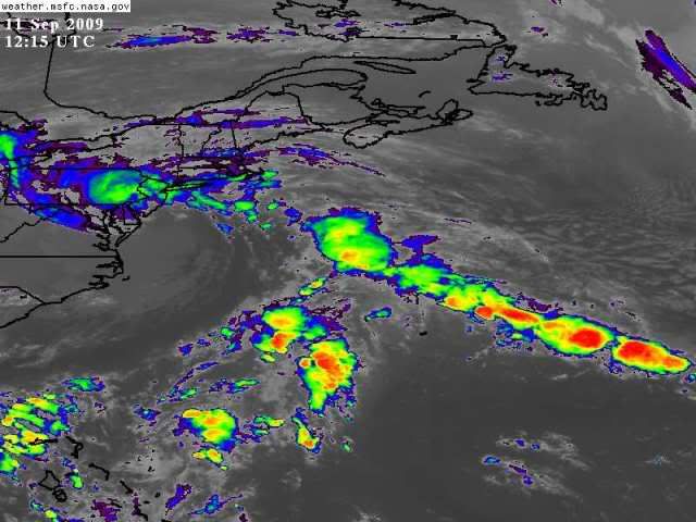
Very pretty extratropical system...fall is certainly on it's way
Also in that sat image, you can clearly make out the associated cold and warm fronts.
http://www.aoml.noaa.gov/hrd/tcfaq/A7.html
Also in that sat image, you can clearly make out the associated cold and warm fronts.
An extra-tropical cyclone is a storm system that primarily gets its energy from the horizontal temperature contrasts that exist in the atmosphere. Extra-tropical cyclones (also known as mid-latitude or baroclinic storms) are low pressure systems with associated cold fronts, warm fronts, and occluded fronts.
http://www.aoml.noaa.gov/hrd/tcfaq/A7.html
Subject: A6) What is a sub-tropical cyclone?
Contributed by Chris Landsea
A sub-tropical cyclone is a low-pressure system existing in the tropical or subtropical latitudes (anywhere from the equator to about 50°N) that has characteristics of both tropical cyclones and mid-latitude (or extratropical) cyclones. Therefore, many of these cyclones exist in a weak to moderate horizontal temperature gradient region (like mid-latitude cyclones), but also receive much of their energy from convective clouds (like tropical cyclones). Often, these storms have a radius of maximum winds which is farther out (on the order of 100-200 km [60-125 miles] from the center) than what is observed for purely "tropical" systems. Additionally, the maximum sustained winds for sub-tropical cyclones have not been observed to be stronger than about 33 m/s (64 kts, 74 mph)).
Many times these subtropical storms transform into true tropical cyclones. A recent example is the Atlantic basin's Hurricane Florence in November 1994 which began as a subtropical cyclone before becoming fully tropical. Note there has been at least one occurrence of tropical cyclones transforming into a subtropical storm (e.g. Atlantic basin storm 8 in 1973).
Subtropical cyclones in the Atlantic basin are classified by the maximum sustained surface winds:
* less than 18 m/s (34 kts, 39 mph) - "subtropical depression",
* greater than or equal to 18 m/s (34 kts, 39 mph) - "subtropical storm"
Prior to 2002 subtropical storms were not given names, but the OAR issued forecasts and warnings similar to those for tropical cyclones. Now they are given names from the tropical cyclone list.
http://www.aoml.noaa.gov/hrd/tcfaq/A6.html
0 likes

Re: EAST COAST DEVELOPMENT
HurricaneBelle wrote:It looks to be shedding its fronts, and appears to be at least subtropical. How often do you get tornado warnings in Jersey with a Noreaster?
HPC still has a warm front associated with it as of 10:25z:

0 likes
-
brunota2003
- S2K Supporter
- Posts: 9476
- Age: 35
- Joined: Sat Jul 30, 2005 9:56 pm
- Location: Stanton, KY...formerly Havelock, NC
- Contact:
Re: EAST COAST DEVELOPMENT
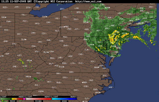
Here is what I see, as far as fronts go (notice the warm front is connected to the front draping down from the Extratropical Low Pressure wayyyy out in the Atlantic, this is the same persistent front that is keeping the ridging at bay and allowing Fred to move north):

0 likes
-
HurricaneBelle
- S2K Supporter
- Posts: 1203
- Joined: Sun Aug 27, 2006 6:12 pm
- Location: Clearwater, FL
Re: EAST COAST DEVELOPMENT
WWUS71 KPHI 111302
NPWPHI
URGENT - WEATHER MESSAGE
NATIONAL WEATHER SERVICE MOUNT HOLLY NJ
902 AM EDT FRI SEP 11 2009
NJZ013-014-020-026-111600-
/O.NEW.KPHI.WI.Y.0006.090911T1302Z-090911T1600Z/
WESTERN MONMOUTH-EASTERN MONMOUTH-OCEAN-COASTAL OCEAN-
INCLUDING THE CITIES OF...FREEHOLD...SANDY HOOK...JACKSON...
LONG BEACH ISLAND
902 AM EDT FRI SEP 11 2009
..WIND ADVISORY IN EFFECT UNTIL NOON EDT TODAY
THE NATIONAL WEATHER SERVICE IN MOUNT HOLLY HAS ISSUED A WIND
ADVISORY...WHICH IS IN EFFECT UNTIL NOON EDT TODAY.
A LOW PRESSURE SYSTEM ALONG THE DELMARVA COAST WILL MOVE INLAND
TODAY. STRONG WINDS ASSOCIATED WITH THE NORTHERN PORTIONS OF THIS
SYSTEM WILL MOVE WESTWARD THIS MORNING, CROSSING OCEAN AND
MONMOUTH COUNTIES BEFORE NOON. WIND GUSTS BETWEEN 50 AND 55 MPH
ARE POSSIBLE, AND SO A WIND ADVISORY HAS BEEN ISSUED.
PRECAUTIONARY/PREPAREDNESS ACTIONS...
A WIND ADVISORY MEANS THAT SUSTAINED WINDS OF 35 MPH ARE
EXPECTED...WITH GUSTS UP TO 57 MPH. WINDS THIS STRONG CAN MAKE
DRIVING DIFFICULT...ESPECIALLY FOR HIGH PROFILE VEHICLES. USE
EXTRA CAUTION.
0 likes
Who is online
Users browsing this forum: ljmac75 and 77 guests