H54 low centered over SW carribean...
http://raleighwx.easternuswx.com/models ... cal054.gif
Disturbance in the western Caribbean (Is invest 98L)
Moderator: S2k Moderators
Forum rules

The posts in this forum are NOT official forecasts and should not be used as such. They are just the opinion of the poster and may or may not be backed by sound meteorological data. They are NOT endorsed by any professional institution or STORM2K. For official information, please refer to products from the National Hurricane Center and National Weather Service.
-
srainhoutx

- S2K Supporter

- Posts: 6919
- Age: 68
- Joined: Sun Jan 14, 2007 11:34 am
- Location: Haywood County, NC
- Contact:
Re: ATL: Disturbance in the west/central Caribbean
You guys are slipping...HPC:
SUBTROPICAL DEPRESSION SEVENTEEN EXPECTED TO MOVE NORTHEAST AND
WELL SEAWARD OVER TEH NEXT SEVERAL DAYS. CONDITIONS APPEAR
FAVORABLE FOR ADDITIONAL TROPICAL CYCLOGENESIS IN THE SOUTHWEST
CARRIBEAN WITH GOOD MODEL AND ENSEMBLE CLUSTERING WITH A SLOW WEST
TO NORTHWEST MOVEMENT TO OFF THE HONDURAS COAST BY DAYS 7
WEDNESDAY. SEE NHC DISCUSSIONS/ADVISORIES.
0 likes
Carla/Alicia/Jerry(In The Eye)/Michelle/Charley/Ivan/Dennis/Katrina/Rita/Wilma/Ike/Harvey
Member: National Weather Association
Wx Infinity Forums
http://wxinfinity.com/index.php
Facebook.com/WeatherInfinity
Twitter @WeatherInfinity
Member: National Weather Association
Wx Infinity Forums
http://wxinfinity.com/index.php
Facebook.com/WeatherInfinity
Twitter @WeatherInfinity

-
Blown Away

- S2K Supporter
- Posts: 10253
- Joined: Wed May 26, 2004 6:17 am
Re: ATL: Disturbance in the west/central Caribbean

TAFB now showing a surface low in 72 hours.
0 likes
Hurricane Eye Experience: David 79, Irene 99, Frances 04, Jeanne 04, Wilma 05… Hurricane Brush Experience: Andrew 92, Erin 95, Floyd 99, Matthew 16, Irma 17, Ian 22, Nicole 22…
-
Hurricaneman

- Category 5

- Posts: 7404
- Age: 45
- Joined: Tue Aug 31, 2004 3:24 pm
- Location: central florida
Re: ATL: Disturbance in the west/central Caribbean
looks to be an organizing low at 96h on the 0zgfs
0 likes
-
dwsqos2
Re: ATL: Disturbance in the west/central Caribbean
The 0Z Euro is quite anemic through hour 120. Another dud?
There's still not much on the Euro through hour 168. Neither the 0Z cmc nor the 0Z gfs does much with this. Oh well.
And, the Euro still progs rather low heights over much of the Eastern U.S. I hate this; perhaps during December-February we will finally see glorious 500 mb ridges. I hope for scalding late fall through early spring.
0 likes
-
Shuriken
Re: ATL: Disturbance in the west/central Caribbean
The current convective blow-up in the western Caribbean has quickly developed an associated surface whirl at its SE end visible on IR2 (time-sensitive): http://www.ssd.noaa.gov/goes/east/watl/flash-ir2.html
Motion is slow S or SSE.
Motion is slow S or SSE.
0 likes

Re: ATL: Disturbance in the west/central Caribbean
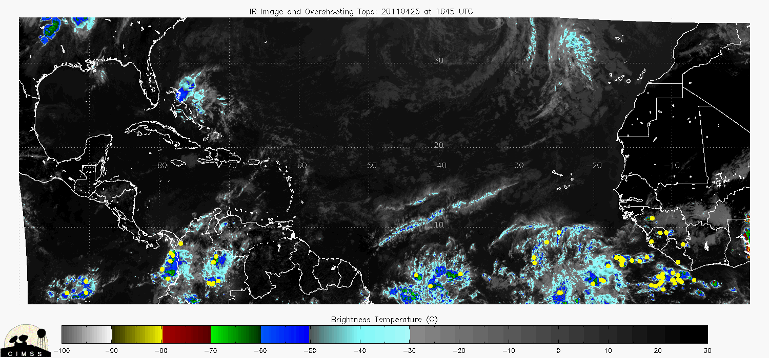
Had a high rain-rate cell fire up at 3:15Z for about hour and a half.
Rain rate has since diminished but clouds are topping around 45K-ft.
This could be the cirrus left from the high-rain rate cumulus nimbus.
Looks like there still may be some overshooting tops.
Will be able to tell what happened when get a clear view on vis-sat.


Rain rate has since diminished but clouds are topping around 45K-ft.
This could be the cirrus left from the high-rain rate cumulus nimbus.
Looks like there still may be some overshooting tops.
Will be able to tell what happened when get a clear view on vis-sat.
0 likes
Re: ATL: Disturbance in the west/central Caribbean
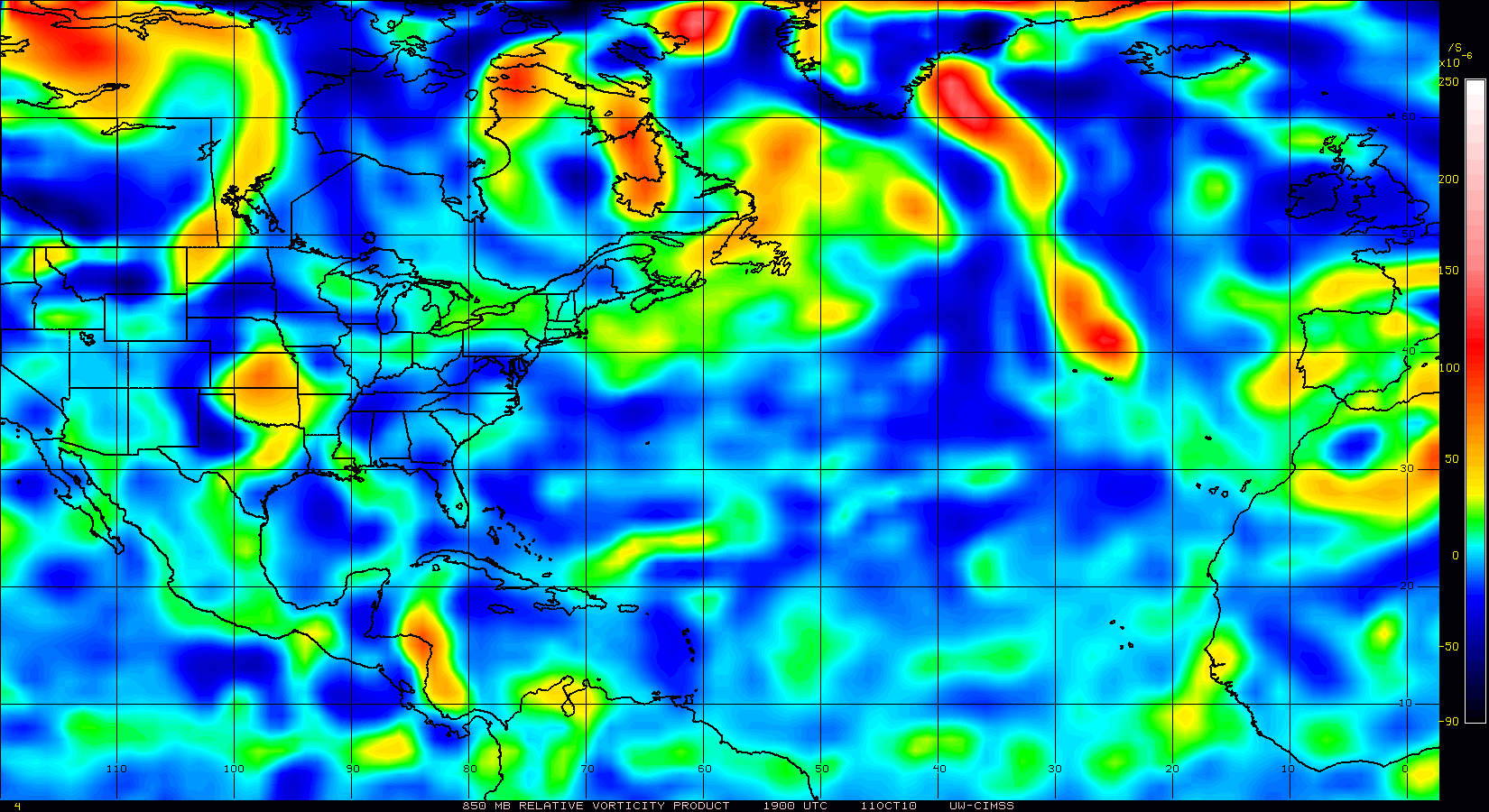
850mb vorticity is improving and UL outflow looks very good.

0 likes
-
cycloneye

- Admin

- Posts: 149585
- Age: 69
- Joined: Thu Oct 10, 2002 10:54 am
- Location: San Juan, Puerto Rico
Re: ATL: Disturbance in the west/central Caribbean
TROPICAL WEATHER OUTLOOK
NWS TPC/NATIONAL HURRICANE CENTER MIAMI FL
800 AM EDT THU OCT 7 2010
FOR THE NORTH ATLANTIC...CARIBBEAN SEA AND THE GULF OF MEXICO...
THE NATIONAL HURRICANE CENTER IS ISSUING ADVISORIES ON SUBTROPICAL
STORM OTTO...LOCATED ABOUT 235 MILES NORTHEAST OF GRAND TURK
ISLAND AND ABOUT 635 MILES SOUTH-SOUTHWEST OF BERMUDA.
A SURFACE LOW PRESSURE TROUGH IS PRODUCING AN AREA OF SHOWERS AND
THUNDERSTORMS OVER THE WEST-CENTRAL CARIBBEAN SEA ABOUT MIDWAY
BETWEEN HONDURAS AND JAMAICA. DEVELOPMENT OF THIS DISTURBANCE...
IF ANY...SHOULD BE SLOW TO OCCUR AS IT MOVES SOUTHWARD AT 10 TO 15
MPH. THERE IS A LOW CHANCE...10 PERCENT...OF THIS SYSTEM BECOMING A
TROPICAL CYCLONE DURING THE NEXT 48 HOURS.
ELSEWHERE...TROPICAL CYCLONE FORMATION IS NOT EXPECTED DURING THE
NEXT 48 HOURS.
$$
FORECASTER STEWART
0 likes
Visit the Caribbean-Central America Weather Thread where you can find at first post web cams,radars
and observations from Caribbean basin members Click Here
and observations from Caribbean basin members Click Here
-
HURRICANELONNY
- Category 5
- Posts: 1392
- Joined: Wed May 07, 2003 6:48 am
- Location: HOLLYWOOD.FL
Re: Disturbance in the west/central Caribbean - Code Yellow
Beat me to the outlook. Moving South. Doesn't look like any threat to US.
0 likes
hurricanelonny
Re: Disturbance in the west/central Caribbean - Code Yellow
NWS Miami not too concerned and rightfully so with the pattern into the foreseable future.
.EXTENDED FORECAST...
THE LONG RANGE MODELS ARE STILL SHOWING A DISTURBANCE OVER THE
WESTERN CARIBBEAN SEA TO MOVE NORTHEAST THROUGH CUBA AND INTO THE
BAHAMA ISLANDS EARLY TO MIDDLE OF NEXT WEEK...AS A TROUGH OF LOW
PRESSURE DEVELOPS OVER THE EASTERN UNITED STATES. THIS COULD BRING
IN SOME ISOLATED SHOWERS TO THE AREA FOR EARLY TO MIDDLE OF NEXT
WEEK...BUT THE DEEP MOISTURE ASSOCIATED WITH THE TROPICAL
DISTURBANCE SHOULD REMAIN SOUTH OF THE CWA DURING THIS TIME.
0 likes

Re: Disturbance in the west/central Caribbean - Code Yellow
Just a little convection west of Jamaica this morning. As cool as it has been the past few mornings in Florida its beginning to feel like it might be season over after Otto. With one more we would have16 named storms for 2010. They were expecting 14 to 23 back in May 16 would be slightly above normal.
0 likes
Re: Disturbance in the west/central Caribbean - Code Yellow
Overshooting cumulus-nimbus continuing to fire thru the cirrus base.
http://www.tropicalatlantic.com/satelli ... 18&lon=-82
http://www.tropicalatlantic.com/satelli ... 18&lon=-82
0 likes
Re: Disturbance in the west/central Caribbean - Code Yellow
GCANE wrote:Overshooting cumulus-nimbus continuing to fire thru the cirrus base.
http://www.tropicalatlantic.com/satelli ... 18&lon=-82
Nice image there GCANE...It should be interesting to see how this evolves the next few days..I do think well have Paula by Sunday/Monday...
0 likes
-
CourierPR

- Category 5
- Posts: 1336
- Age: 72
- Joined: Tue Aug 31, 2004 7:53 pm
- Location: Pompano Beach, Florida
Re: Disturbance in the west/central Caribbean - Code Yellow
I just watched tropical video on AccuWeather and Met. Mark Mancuso indicated that this will probably be Paula by next week.
0 likes

Re: Disturbance in the west/central Caribbean - Code Yellow
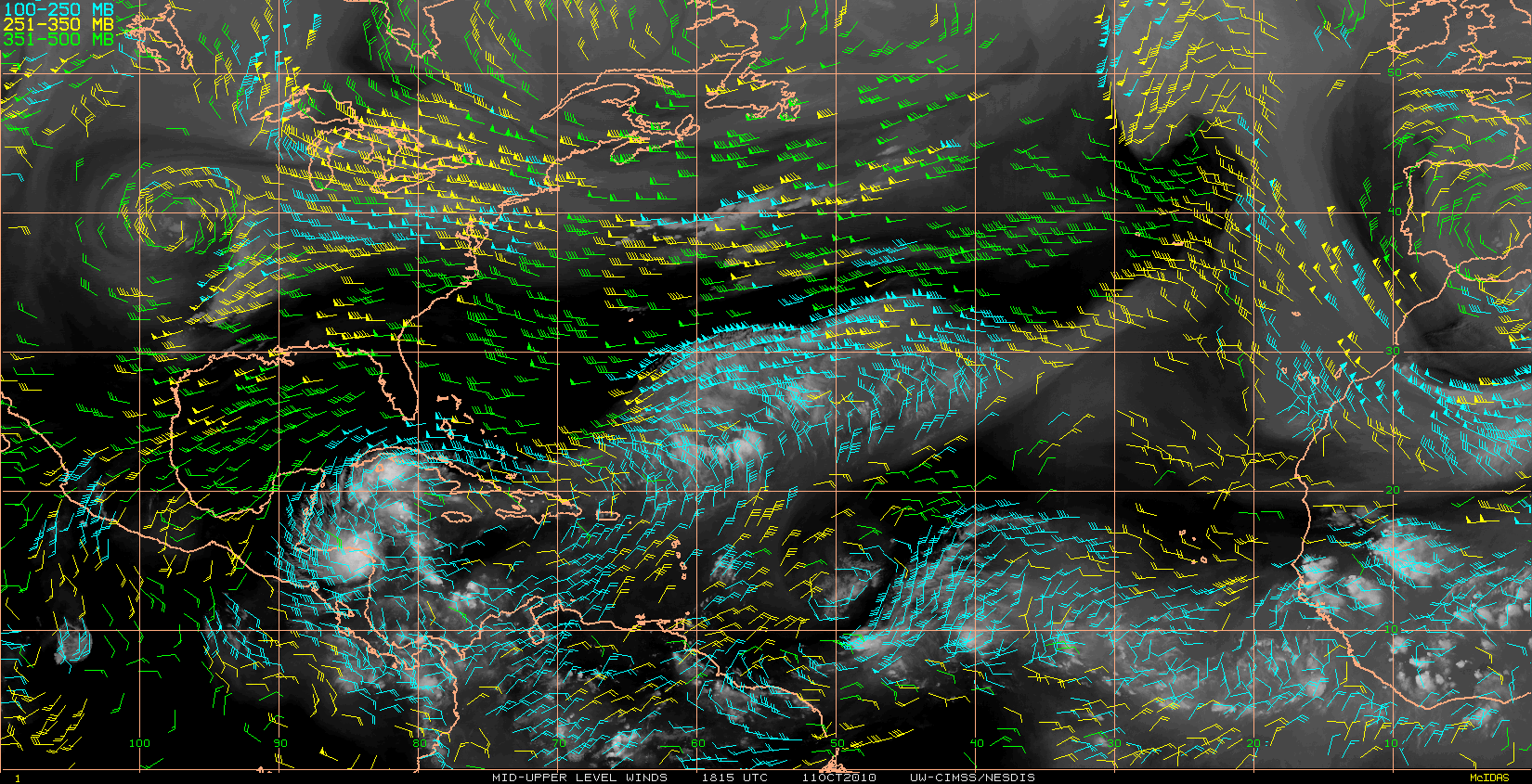
Not looking too bad. We have a few 30kt barbs.


0 likes
Re: Disturbance in the west/central Caribbean - Code Yellow
Vortex wrote:GCANE wrote:Overshooting cumulus-nimbus continuing to fire thru the cirrus base.
http://www.tropicalatlantic.com/satelli ... 18&lon=-82
Nice image there GCANE...It should be interesting to see how this evolves the next few days..I do think well have Paula by Sunday/Monday...
Thanks Vortex and I agree with you.
Still plenty of hot-water down there and plenty of time for it to sit there and stew.
0 likes
-
Blown Away
- S2K Supporter
- Posts: 10253
- Joined: Wed May 26, 2004 6:17 am
Re: Disturbance in the west/central Caribbean - Code Yellow
GCANE wrote:Vortex wrote:GCANE wrote:Overshooting cumulus-nimbus continuing to fire thru the cirrus base.
http://www.tropicalatlantic.com/satelli ... 18&lon=-82
Nice image there GCANE...It should be interesting to see how this evolves the next few days..I do think well have Paula by Sunday/Monday...
Thanks Vortex and I agree with you.
Still plenty of hot-water down there and plenty of time for it to sit there and stew.
Confident the trough next week will be able to lift this low out of the Caribbean? Seems the westerly flow over SFL should keep this area to the south and east?
0 likes
Hurricane Eye Experience: David 79, Irene 99, Frances 04, Jeanne 04, Wilma 05… Hurricane Brush Experience: Andrew 92, Erin 95, Floyd 99, Matthew 16, Irma 17, Ian 22, Nicole 22…
Who is online
Users browsing this forum: Iceresistance, shah83, Ulf and 244 guests