Tropical Wave in NW Caribbean/Yucatan (Is Invest 95L)
Moderator: S2k Moderators
Forum rules

The posts in this forum are NOT official forecasts and should not be used as such. They are just the opinion of the poster and may or may not be backed by sound meteorological data. They are NOT endorsed by any professional institution or STORM2K. For official information, please refer to products from the National Hurricane Center and National Weather Service.
-
Riptide

- Category 2

- Posts: 753
- Age: 34
- Joined: Fri Jul 23, 2010 3:33 pm
- Location: Cape May, New Jersey
- Contact:
Re: Tropical Wave / Pouch 20L in Central Atlantic
Needs to be invested, is the most threatening system right now for the conus, in my opinion. The overall structure is still embedded in the ITCZ and may not develop for quite some time.
0 likes
-
floridasun78
- Category 5

- Posts: 3755
- Joined: Sun May 17, 2009 10:16 pm
- Location: miami fl
-
caneman
Re: Tropical Wave / Pouch 20L in Central Atlantic
Might be time for a new hobby  There sure hasn't been much to track the last couple of years. We're heading into the latter 2/3rd's of August now.
0 likes
Re: Tropical Wave / Pouch 20L in Central Atlantic
caneman wrote:Might be time for a new hobby
Give us until Late-September. I have a feeling there will be a couple fun ones to track.
0 likes
-
jlauderdal
- S2K Supporter

- Posts: 7240
- Joined: Wed May 19, 2004 5:46 am
- Location: NE Fort Lauderdale
- Contact:
Re: Tropical Wave / Pouch 20L in Central Atlantic
caneman wrote:Might be time for a new hobby
you live in florida, plenty of opportunity ahead
0 likes
-
Gustywind

- Category 5
- Posts: 12334
- Joined: Mon Sep 03, 2007 7:29 am
- Location: Baie-Mahault, GUADELOUPE
2 AM Discussion.
TROPICAL WAVE APPROACHING THE LESSER ANTILLES EXTENDS FROM
20N59W TO 9N59W MOVING W 10-15 KT. WAVE REMAINS EMBEDDED WITHIN
AN AREA OF MODERATE MOISTURE AS DEPICTED IN TOTAL PRECIPITABLE
WATER IMAGERY. SCATTERED SHOWERS ARE FROM 11N-13N BETWEEN 58W-
59W.

By the way, Guadeloupe is since 530 AM under an yellow alert for a risk of strong and tstorms due to the arrival of this moderate twave. Let's see what pan's out from this feature. I will keep your informed if anything happens in the butterfky island.
TROPICAL WAVE APPROACHING THE LESSER ANTILLES EXTENDS FROM
20N59W TO 9N59W MOVING W 10-15 KT. WAVE REMAINS EMBEDDED WITHIN
AN AREA OF MODERATE MOISTURE AS DEPICTED IN TOTAL PRECIPITABLE
WATER IMAGERY. SCATTERED SHOWERS ARE FROM 11N-13N BETWEEN 58W-
59W.
By the way, Guadeloupe is since 530 AM under an yellow alert for a risk of strong and tstorms due to the arrival of this moderate twave. Let's see what pan's out from this feature. I will keep your informed if anything happens in the butterfky island.
0 likes
-
Gustywind
- Category 5
- Posts: 12334
- Joined: Mon Sep 03, 2007 7:29 am
- Location: Baie-Mahault, GUADELOUPE
For those who are interrested (french version), here is the link related to the yellow alert for Guadeloupe:
http://www.meteo.gp/EspacePro/donnees/b ... ilance.php
http://www.meteo.fr/temps/domtom/antill ... ivi_gd.pdf
http://www.meteo.gp/EspacePro/donnees/b ... ilance.php
http://www.meteo.fr/temps/domtom/antill ... ivi_gd.pdf
0 likes
-
Gustywind
- Category 5
- Posts: 12334
- Joined: Mon Sep 03, 2007 7:29 am
- Location: Baie-Mahault, GUADELOUPE
8 AM Discussion. Looks like twave is moving less quicker 10 kts and is gaining more convection this morning. If the forecasts are correct, Guadeloupe should get more showers and tstorms today. Let's wait and see.
TROPICAL WAVE APPROACHING THE LESSER ANTILLES EXTENDS FROM
20N60W TO 9N60W MOVING W NEAR 10 KT. WAVE REMAINS EMBEDDED
WITHIN AN AREA OF MODERATE MOISTURE AS DEPICTED IN TOTAL
PRECIPITABLE WATER IMAGERY. SCATTERED SHOWERS/ISOLATED
THUNDERSTORMS ARE FROM 91N-13N BETWEEN 59W-61W. SCATTERED
SHOWERS ARE W OF THE WAVE TO OVER THE LESSER ANTILLES TO 62W.
0 likes
-
caneman
Re: Tropical Wave / Pouch 20L in Eastern Caribbean
jlauderdale,
Yeah, I know it just seems that storms are having a hard time getting going. When is the last time we saw a beautiful - text book Hurricane to track?
Yeah, I know it just seems that storms are having a hard time getting going. When is the last time we saw a beautiful - text book Hurricane to track?
0 likes
-
wxman57

- Moderator-Pro Met

- Posts: 23175
- Age: 68
- Joined: Sat Jun 21, 2003 8:06 pm
- Location: Houston, TX (southwest)
Re: Tropical Wave / Pouch 20L in Eastern Caribbean
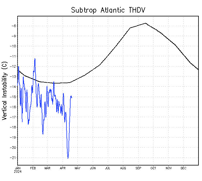
Stable Caribbean:

And very stable Tropical Atlantic:

And very stable Tropical Atlantic:
0 likes


Re: Tropical Wave / Pouch 20L in Eastern Caribbean
caneman wrote:jlauderdale,
Yeah, I know it just seems that storms are having a hard time getting going. When is the last time we saw a beautiful - text book Hurricane to track?
2012.
0 likes
-
northjaxpro

- S2K Supporter
- Posts: 8900
- Joined: Mon Sep 27, 2010 11:21 am
- Location: Jacksonville, FL
Re: Tropical Wave / Pouch 20L in Eastern Caribbean
caneman wrote:jlauderdale,
Yeah, I know it just seems that storms are having a hard time getting going. When is the last time we saw a beautiful - text book Hurricane to track?
Well, for me, the last impressive hurricanes to have tracked across the Atlantic basin were in 2011, Irene (Cat 3), Katia(Cat 4), and Ophelia (Cat 4).
We have not had any impressive hurricanes in the Atlantic basin since then IMO.
0 likes
NEVER, EVER SAY NEVER in the tropics and weather in general, and most importantly, with life itself!!
________________________________________________________________________________________
Fay 2008 Beryl 2012 Debby 2012 Colin 2016 Hermine 2016 Julia 2016 Matthew 2016 Irma 2017 Dorian 2019
________________________________________________________________________________________
Fay 2008 Beryl 2012 Debby 2012 Colin 2016 Hermine 2016 Julia 2016 Matthew 2016 Irma 2017 Dorian 2019

Re: Tropical Wave / Pouch 20L in Eastern Caribbean
wxman57 wrote:Stable Caribbean:
http://www.ssd.noaa.gov/PS/TROP/TCFP/da ... r_THDV.gif
And very stable Tropical Atlantic:
http://www.ssd.noaa.gov/PS/TROP/TCFP/da ... t_THDV.gif
And to make things worst for tropical disturbances this year the subtropical Atlantic has also been running more stable than average over all, unlike last year.
0 likes
-
Riptide
- Category 2
- Posts: 753
- Age: 34
- Joined: Fri Jul 23, 2010 3:33 pm
- Location: Cape May, New Jersey
- Contact:
Re: Tropical Wave / Pouch 20L in Eastern Caribbean
NDG wrote:wxman57 wrote:Stable Caribbean:
http://www.ssd.noaa.gov/PS/TROP/TCFP/da ... l_car_THDV
And very stable Tropical Atlantic:
http://www.ssd.noaa.gov/PS/TROP/TCFP/da ... l_tat_THDV
And to make things worst for tropical disturbances this year the subtropical Atlantic has also been running more stable than average over all, unlike last year.
FWIW, next week the pattern should change in the Western Atlantic and the constant shear and cold front intrusions should be replaced by a Bermuda High.
0 likes
-
TheStormExpert
Re: Tropical Wave / Pouch 20L in Eastern Caribbean
Riptide wrote:FWIW, next week the pattern should change in the Western Atlantic and the constant shear and cold front intrusions should be replaced by a Bermuda High.
People have been saying the patterns going to change for the past month! I'll believe it when I see it.
0 likes
-
ninel conde
Re: Tropical Wave / Pouch 20L in Eastern Caribbean
TheStormExpert wrote:Riptide wrote:FWIW, next week the pattern should change in the Western Atlantic and the constant shear and cold front intrusions should be replaced by a Bermuda High.
People have been saying the patterns going to change for the past month! I'll believe it when I see it.
its the dry air that needs to leave.
0 likes
Who is online
Users browsing this forum: JoshwaDone and 192 guests