
interesting comment in the Tropical Weather Discussion AT 804 AM EDT Mon Oct 1 2018 For Caribbean Sea. So what is left of Kirk is now a trough expected to drift in the Caribbean for several days and possibly become large cyclonic gyre presumably off shore Belize. Hate these waiting & watch games.
"The Caribbean Sea tropical wave that was previously along 76W is
now analyzed as a trough. Scattered moderate convection is
located south of 18N between 72W-82W. Furthermore, scattered
moderate convection is occurring over the southwest Caribbean due
to a combination of this trough and the eastern Pacific monsoon
trough. The trough will remain nearly stationary or perhaps move
very slowly toward the western Caribbean over the next several
days. A large cyclonic gyre could develop over this area by the
end of the week. "
Incidentally week or so ago I saw on I think it was Euro model run something form down in the Sea nr Columbia area on Oct 2 and shoot across Caribbean to Haiti/Dominican Republic. That scenario was gone the next day.
Broad area of disturbed weather in the Western Caribbean Sea (Is INVEST 91L)
Moderator: S2k Moderators
Forum rules

The posts in this forum are NOT official forecasts and should not be used as such. They are just the opinion of the poster and may or may not be backed by sound meteorological data. They are NOT endorsed by any professional institution or STORM2K. For official information, please refer to products from the National Hurricane Center and National Weather Service.
Re: Broad area of disturbed weather in the southwestern Caribbean Sea
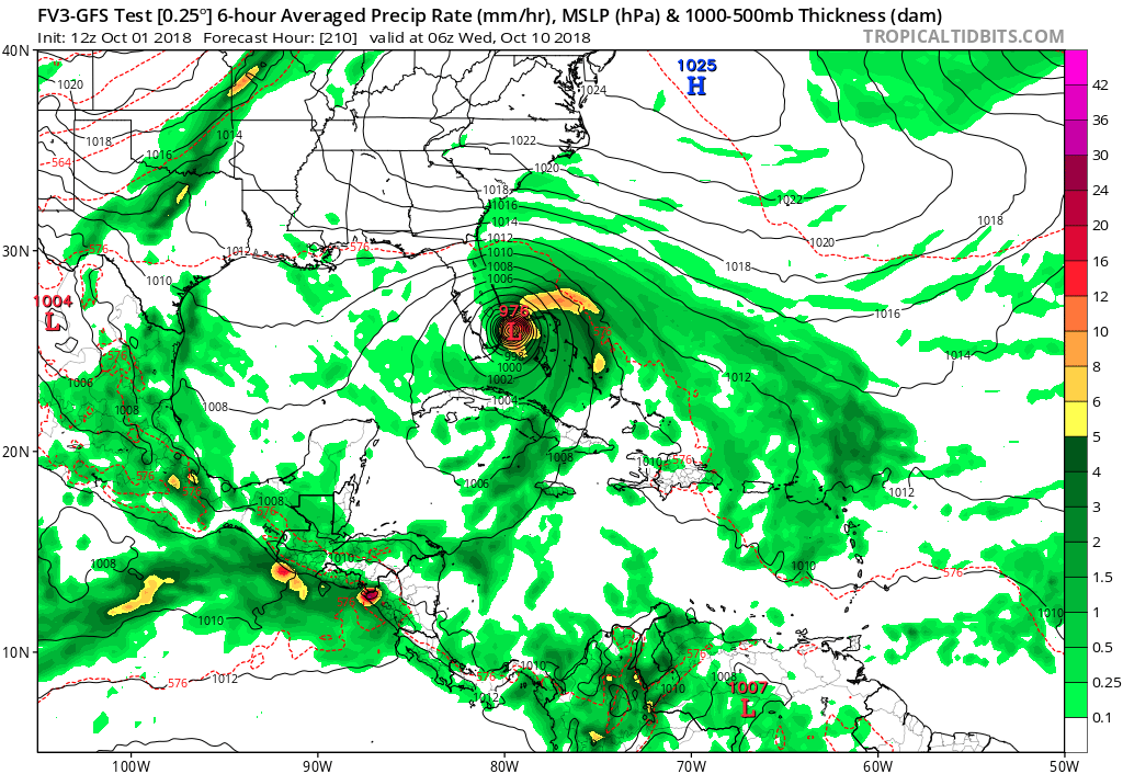
gatorcane wrote:Whoa 12Z FV3 GFS hits SE Florida from the east
https://i.postimg.cc/nhLz3js2/fv3p_mslp_pcpn_watl_35.png
“Ridge over troubled waters:”
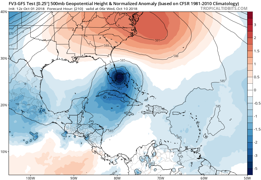
https://i.postimg.cc/7YK7Py0B/fv3p_z500a_Norm_watl_36.png

Gator/others,
Anyone think FV3 strengthening it to cat 2 between Cuba & SOFLA makes sense considering the strong shear just to its north? I know CMC has bias of too much strengthening in face of shear as it did in GOM at 12Z, but does FV3 have same bias?
0 likes
Personal Forecast Disclaimer:
The posts in this forum are NOT official forecasts and should not be used as such. They are just the opinion of the poster and may or may not be backed by sound meteorological data. They are NOT endorsed by any professional institution or storm2k.org. For official information, please refer to the NHC and NWS products.
The posts in this forum are NOT official forecasts and should not be used as such. They are just the opinion of the poster and may or may not be backed by sound meteorological data. They are NOT endorsed by any professional institution or storm2k.org. For official information, please refer to the NHC and NWS products.
-
Aric Dunn
- Category 5

- Posts: 21238
- Age: 43
- Joined: Sun Sep 19, 2004 9:58 pm
- Location: Ready for the Chase.
- Contact:
Re: Broad area of disturbed weather in the southwestern Caribbean Sea
hey look the Euro look much better now.  at least through 120 hours.. likely go down hill from here. but who knows.
at least the vorticity part..
at least the vorticity part..
0 likes
Note: If I make a post that is brief. Please refer back to previous posts for the analysis or reasoning. I do not re-write/qoute what my initial post said each time.
If there is nothing before... then just ask
Space & Atmospheric Physicist, Embry-Riddle Aeronautical University,
I believe the sky is falling...
If there is nothing before... then just ask
Space & Atmospheric Physicist, Embry-Riddle Aeronautical University,
I believe the sky is falling...
-
Aric Dunn
- Category 5
- Posts: 21238
- Age: 43
- Joined: Sun Sep 19, 2004 9:58 pm
- Location: Ready for the Chase.
- Contact:
Re: Broad area of disturbed weather in the southwestern Caribbean Sea
and at 144 hours.. we have 4 possibly 5 distinct vorts from belize ene to north of DR.... and we wait..
0 likes
Note: If I make a post that is brief. Please refer back to previous posts for the analysis or reasoning. I do not re-write/qoute what my initial post said each time.
If there is nothing before... then just ask
Space & Atmospheric Physicist, Embry-Riddle Aeronautical University,
I believe the sky is falling...
If there is nothing before... then just ask
Space & Atmospheric Physicist, Embry-Riddle Aeronautical University,
I believe the sky is falling...
-
SFLcane

- S2K Supporter

- Posts: 10281
- Age: 48
- Joined: Sat Jun 05, 2010 1:44 pm
- Location: Lake Worth Florida
Re: Broad area of disturbed weather in the southwestern Caribbean Sea
Very plausible track if you asked me with that massive ridge overhead.

1 likes
-
DESTRUCTION5

- Category 5
- Posts: 4430
- Age: 44
- Joined: Wed Sep 03, 2003 11:25 am
- Location: Stuart, FL
Re: Broad area of disturbed weather in the southwestern Caribbean Sea
SFLcane wrote:Very plausible track if you asked me with that massive ridge overhead.
https://www.imageupload.co.uk/images/2018/10/01/yep.gif
I must have missed the memo sometime...is this model considered the new GFS?
0 likes
GATOR NATION IS E V E R Y W H E R E !
-
stormlover2013
Re: Broad area of disturbed weather in the southwestern Caribbean Sea
I am looking for a good rain maker, still early but don't seem anything right now that would make me nervous with the high shear, now no shear then it would be a problem.
0 likes

Re: Broad area of disturbed weather in the southwestern Caribbean Sea
DESTRUCTION5 wrote:SFLcane wrote:Very plausible track if you asked me with that massive ridge overhead.
https://www.imageupload.co.uk/images/2018/10/01/yep.gif
I must have missed the memo sometime...is this model considered the new GFS?
Will be starting in 2019.
0 likes
Re: Broad area of disturbed weather in the southwestern Caribbean Sea
12z Euro - weak vorticity into south FL - no real development.
0 likes
-
TheStormExpert
Re: Broad area of disturbed weather in the southwestern Caribbean Sea
SFLcane wrote:Very plausible track if you asked me with that massive ridge overhead.
https://www.imageupload.co.uk/images/2018/10/01/yep.gif
Track plausible, strength not so much.
0 likes
-
toad strangler

- S2K Supporter
- Posts: 4546
- Joined: Sun Jul 28, 2013 3:09 pm
- Location: Earth
- Contact:
Re: Broad area of disturbed weather in the southwestern Caribbean Sea
Euro doesn't even show a low at 850 mb at 216
0 likes
My Weather Station
https://www.wunderground.com/dashboard/pws/KFLPORTS603
https://www.wunderground.com/dashboard/pws/KFLPORTS603
Re: Broad area of disturbed weather in the southwestern Caribbean Sea
SFLcane wrote:Very plausible track if you asked me with that massive ridge overhead.
https://www.imageupload.co.uk/images/2018/10/01/yep.gif
This is a 1 in 10 year early Oct track of a hit on the SE coast from the ATL, which I agree is plausible with that strong 500 mb high to its north. But what I don’t think is plausible is the strengthening to from TS at Cuba to solid cat 2 SoFL with screaming 200 mb winds/30-50+ knot shear surrounding it all the way from Cuba to FL. Does anyone think this is plausible? I’d think it would remain a TS at most with that shear. Anyone disagree? Here’s the key Q: does this model have an overstrengthening bias in face of shear like CMC has?
1 likes
Personal Forecast Disclaimer:
The posts in this forum are NOT official forecasts and should not be used as such. They are just the opinion of the poster and may or may not be backed by sound meteorological data. They are NOT endorsed by any professional institution or storm2k.org. For official information, please refer to the NHC and NWS products.
The posts in this forum are NOT official forecasts and should not be used as such. They are just the opinion of the poster and may or may not be backed by sound meteorological data. They are NOT endorsed by any professional institution or storm2k.org. For official information, please refer to the NHC and NWS products.
-
SFLcane
- S2K Supporter
- Posts: 10281
- Age: 48
- Joined: Sat Jun 05, 2010 1:44 pm
- Location: Lake Worth Florida
Re: Broad area of disturbed weather in the southwestern Caribbean Sea
TheStormExpert wrote:SFLcane wrote:Very plausible track if you asked me with that massive ridge overhead.
https://www.imageupload.co.uk/images/2018/10/01/yep.gif
Track plausible, strength not so much.
Conditions north of cuba in the bahamas would be favorable so if there is any development down in the carribean look out.
0 likes
-
toad strangler
- S2K Supporter
- Posts: 4546
- Joined: Sun Jul 28, 2013 3:09 pm
- Location: Earth
- Contact:
Re: Broad area of disturbed weather in the southwestern Caribbean Sea
LarryWx wrote:SFLcane wrote:Very plausible track if you asked me with that massive ridge overhead.
https://www.imageupload.co.uk/images/2018/10/01/yep.gif
This is a 1 in 10 year early Oct track of a hit on the SE coast from the ATL, which I agree is plausible with that strong 500 mb high to its north. But what I don’t think is plausible is the strengthening to from TS at Cuba to solid cat 2 SoFL with screaming 200 mb winds/30-50+ knot shear surrounding it all the way from Cuba to FL. Does anyone think this is plausible? I’d think it would remain a TS at most with that shear. Anyone disagree? Here’s the key Q: does this model have an overstrengthening bias in face of shear like CMC has?
No. Unless the shear forecast busts
1 likes
My Weather Station
https://www.wunderground.com/dashboard/pws/KFLPORTS603
https://www.wunderground.com/dashboard/pws/KFLPORTS603
Re: Broad area of disturbed weather in the southwestern Caribbean Sea
SFLcane wrote:TheStormExpert wrote:SFLcane wrote:Very plausible track if you asked me with that massive ridge overhead.
https://www.imageupload.co.uk/images/2018/10/01/yep.gif
Track plausible, strength not so much.
Conditions north of cuba in the bahamas would be favorable so if there is any development down in the carribean look out.
Did you see how high the shear is on the FV3 that brings it to cat 2?
0 likes
Personal Forecast Disclaimer:
The posts in this forum are NOT official forecasts and should not be used as such. They are just the opinion of the poster and may or may not be backed by sound meteorological data. They are NOT endorsed by any professional institution or storm2k.org. For official information, please refer to the NHC and NWS products.
The posts in this forum are NOT official forecasts and should not be used as such. They are just the opinion of the poster and may or may not be backed by sound meteorological data. They are NOT endorsed by any professional institution or storm2k.org. For official information, please refer to the NHC and NWS products.
Re: Broad area of disturbed weather in the southwestern Caribbean Sea
toad strangler wrote:Euro doesn't even show a low at 850 mb at 216
It finally does at 240 - a weak 1007 mb low just east of Florida.
1 likes
Re: Broad area of disturbed weather in the southwestern Caribbean Sea
toad strangler wrote:Euro doesn't even show a low at 850 mb at 216
The Euro’s lack of strengthening makes sense to me as it is handling the high shear correctly unlike the FV3. Anyone disagree?
0 likes
Personal Forecast Disclaimer:
The posts in this forum are NOT official forecasts and should not be used as such. They are just the opinion of the poster and may or may not be backed by sound meteorological data. They are NOT endorsed by any professional institution or storm2k.org. For official information, please refer to the NHC and NWS products.
The posts in this forum are NOT official forecasts and should not be used as such. They are just the opinion of the poster and may or may not be backed by sound meteorological data. They are NOT endorsed by any professional institution or storm2k.org. For official information, please refer to the NHC and NWS products.
-
toad strangler
- S2K Supporter
- Posts: 4546
- Joined: Sun Jul 28, 2013 3:09 pm
- Location: Earth
- Contact:
Re: Broad area of disturbed weather in the southwestern Caribbean Sea
12z Euro finally pops a low and a semi cohesive vort signature at the 240 hour end E of N Florida / GA / SC
Last edited by toad strangler on Mon Oct 01, 2018 2:03 pm, edited 1 time in total.
0 likes
My Weather Station
https://www.wunderground.com/dashboard/pws/KFLPORTS603
https://www.wunderground.com/dashboard/pws/KFLPORTS603
-
SFLcane
- S2K Supporter
- Posts: 10281
- Age: 48
- Joined: Sat Jun 05, 2010 1:44 pm
- Location: Lake Worth Florida
Re: Broad area of disturbed weather in the southwestern Caribbean Sea
Here is your daily dose of nogaps.. 

0 likes
Who is online
Users browsing this forum: No registered users and 99 guests