Tropical Wave WSW of the Cabo Verde Islands (Is Invest 91L)
Moderator: S2k Moderators
Forum rules

The posts in this forum are NOT official forecasts and should not be used as such. They are just the opinion of the poster and may or may not be backed by sound meteorological data. They are NOT endorsed by any professional institution or STORM2K. For official information, please refer to products from the National Hurricane Center and National Weather Service.
-
lsuhurricane
- Category 1

- Posts: 270
- Joined: Tue Aug 15, 2017 2:53 pm
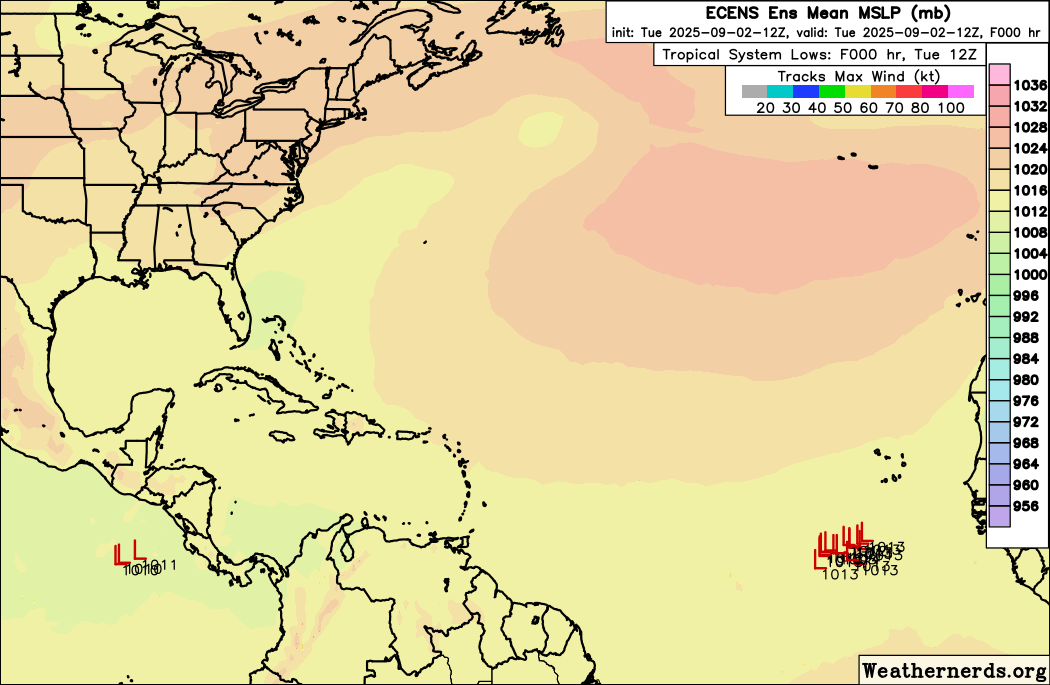
Re: Tropical Wave South of the Cabo Verde Islands (30/70)
As a modest TS, 12z ICON backs way off of its 0z solution and keeps it riding 15N at a westward clip.
1 likes

Re: Tropical Wave South of the Cabo Verde Islands (30/70)
12Z ICON is much weaker than and S of the 0Z run and has WSW motion to 15N, 49W at 168 well below a 600 dm H5 high at a steady state 1003 mb/TS.
1 likes
Personal Forecast Disclaimer:
The posts in this forum are NOT official forecasts and should not be used as such. They are just the opinion of the poster and may or may not be backed by sound meteorological data. They are NOT endorsed by any professional institution or storm2k.org. For official information, please refer to the NHC and NWS products.
The posts in this forum are NOT official forecasts and should not be used as such. They are just the opinion of the poster and may or may not be backed by sound meteorological data. They are NOT endorsed by any professional institution or storm2k.org. For official information, please refer to the NHC and NWS products.
Re: Tropical Wave South of the Cabo Verde Islands (30/70)
This system won't be zipping across the Atlantic quite as fast as Erin did. (snapshot vs erin thread here) at 120 hours erin was already north of the Caribbean, vs here where it's still well east of it.
4 likes
Re: Tropical Wave South of the Cabo Verde Islands (30/70)
12Z UKMET, after having it for the first run in a couple of days as a TD on the 0Z run (though it later weakened), is back to having the low too weak to be classified as a TC.
0 likes
Personal Forecast Disclaimer:
The posts in this forum are NOT official forecasts and should not be used as such. They are just the opinion of the poster and may or may not be backed by sound meteorological data. They are NOT endorsed by any professional institution or storm2k.org. For official information, please refer to the NHC and NWS products.
The posts in this forum are NOT official forecasts and should not be used as such. They are just the opinion of the poster and may or may not be backed by sound meteorological data. They are NOT endorsed by any professional institution or storm2k.org. For official information, please refer to the NHC and NWS products.
-
lsuhurricane
- Category 1
- Posts: 270
- Joined: Tue Aug 15, 2017 2:53 pm
Re: Tropical Wave South of the Cabo Verde Islands (30/70)
That is NOT an upper-level pattern favoring recurve! 12z GFS. Very strong high pressure.

0 likes
-
StormWeather

- Category 1
- Posts: 477
- Joined: Wed Jun 05, 2024 2:34 pm
Re: Tropical Wave South of the Cabo Verde Islands (30/70)
lsuhurricane wrote:That is NOT an upper-level pattern favoring recurve! 12z GFS. Very strong high pressure.
https://www.tropicaltidbits.com/analysis/models/gfs/2025090212/gfs_z500a_atl_32.png
I looked at the successive runs of the GFS from 12Z yesterday to the 12Z run of today (September 10th, 12Z timestamp) and it appears that the GFS has trended further south. Concerning to see. Let’s see if it holds or returns to a safe (as safe as it can be with the pattern) recurve.
1 likes
Just an average cyclone tracker
The posts in this forum are NOT official forecasts and should not be used as such. They are just the opinion of the poster and may or may not be backed by sound meteorological data. They are NOT endorsed by any professional institution or storm2k.org. For official information, please refer to the NHC and NWS products
The posts in this forum are NOT official forecasts and should not be used as such. They are just the opinion of the poster and may or may not be backed by sound meteorological data. They are NOT endorsed by any professional institution or storm2k.org. For official information, please refer to the NHC and NWS products

Re: Tropical Wave South of the Cabo Verde Islands (30/70)
12z GFS is further south and much stronger. Not enough to be a threat to the islands, but Bermuda may be in trouble.
0 likes
Igor 2010, Sandy 2012, Fay 2014, Gonzalo 2014, Joaquin 2015, Nicole 2016, Humberto 2019, Imelda 2025
I am only a tropical weather enthusiast. My predictions are not official and may or may not be backed by sound meteorological data. For official information, please refer to the NHC and NWS products.
I am only a tropical weather enthusiast. My predictions are not official and may or may not be backed by sound meteorological data. For official information, please refer to the NHC and NWS products.
-
TampaWxLurker
- Tropical Storm

- Posts: 196
- Joined: Thu Aug 01, 2024 8:20 am
Re: Tropical Wave South of the Cabo Verde Islands (30/70)
12z Canadian recurves east of the Caribbean, never gets west of 61W. This is left of the 0z, though, but I think the 12z runs are more concerning for Bermuda than before. Better for the Caribbean Islands.
0 likes
Re: Tropical Wave South of the Cabo Verde Islands (30/70)
Looks like Lorena in the EPAC will play a future role with this system. Her remnants seem to help form a cutoff low in the SE as potential future Gabrielle turns north. Important to watch since if Gabrielle trends far enough west and that low is strong enough it could pinwheel around it. Already happened on the 9/1 0z run of the GFS, albeit with a seperate feature.
3 likes
-
cycloneye

- Admin

- Posts: 149689
- Age: 69
- Joined: Thu Oct 10, 2002 10:54 am
- Location: San Juan, Puerto Rico
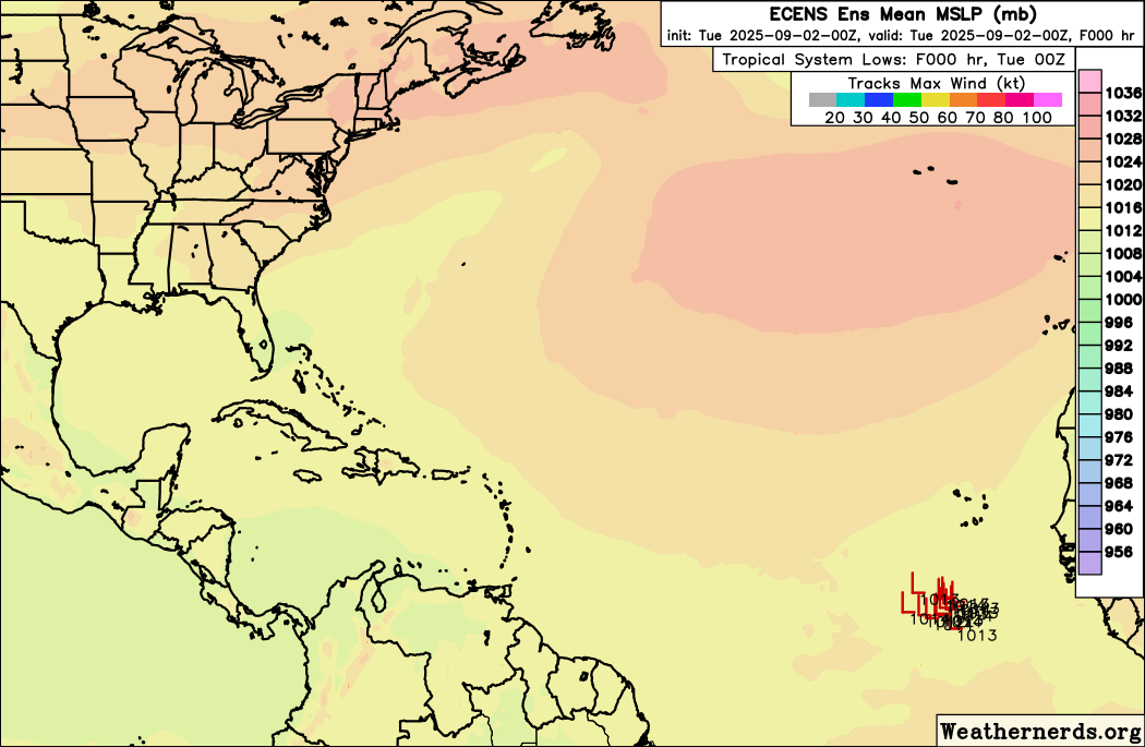
Re: Tropical Wave SW of the Cabo Verde Islands (30/70)
Tropical Weather Outlook
NWS National Hurricane Center Miami FL
Issued by the NWS Weather Prediction Center College Park MD
200 PM EDT Tue Sep 2 2025
For the North Atlantic...Caribbean Sea and the Gulf of America:
Eastern Tropical Atlantic:
A tropical wave is located over the far eastern tropical Atlantic
southwest of the Cabo Verde islands and continues to produce
disorganized showers and thunderstorms. Environmental conditions
remain conducive for gradual development of this system during
the next several days, and a tropical depression is likely to form
late this week or this weekend. This system is expected to
initially move slowly westward and then gradually accelerate
westward to west-northwestward at around 15 mph across the eastern
and central tropical Atlantic into early next week.
* Formation chance through 48 hours...low...30 percent.
* Formation chance through 7 days...high...70 percent.
$$
Forecaster Gallina

1 likes
Visit the Caribbean-Central America Weather Thread where you can find at first post web cams,radars
and observations from Caribbean basin members Click Here
and observations from Caribbean basin members Click Here
-
TomballEd
- Category 5

- Posts: 1317
- Age: 62
- Joined: Wed Aug 16, 2023 4:52 pm
- Location: Spring/Klein area, not Tomball
Re: Tropical Wave South of the Cabo Verde Islands (30/70)
lsuhurricane wrote:That is NOT an upper-level pattern favoring recurve! 12z GFS. Very strong high pressure.
https://i.ibb.co/gFSJSJ6k/Screenshot-2025-09-02-112524.png
An EC trough seems to be able to recurve it passing E of Bermuda. They'd have weather if model verified perfectly, but otherwise a fish sto
0 likes

Re: Tropical Wave SW of the Cabo Verde Islands (30/70)
12Z ECM following along with the idea of a ridge to the north at 5 days system centered near 16N.
Beyond 120 hours the ridge evolution and track don't need me to weigh in.

Beyond 120 hours the ridge evolution and track don't need me to weigh in.
0 likes
-
lsuhurricane
- Category 1
- Posts: 270
- Joined: Tue Aug 15, 2017 2:53 pm
Re: Tropical Wave SW of the Cabo Verde Islands (30/70)
Yeah, this Euro run gets closer to the Lesser Antilles than the 0z run before stair stepping NW.
1 likes
Re: Tropical Wave SW of the Cabo Verde Islands (30/70)
12z Euro gets very close to the islands, but not over it, but later goes right over Bermuda as a cat 3.
Euro over bermuda:

Euro over bermuda:
0 likes
Re: Tropical Wave SW of the Cabo Verde Islands (30/70)
lsuhurricane wrote:Yeah, this Euro run gets closer to the Lesser Antilles than the 0z run before stair stepping NW.
For the record but fwiw since it’s still well out in wild guessing land, the 12Z Euro directly hits Bermuda 9/14-5 as a MH as it moves NE.
**Mods, please delete this as someone else posted this just before me while I was typing this. Thanks.
0 likes
Personal Forecast Disclaimer:
The posts in this forum are NOT official forecasts and should not be used as such. They are just the opinion of the poster and may or may not be backed by sound meteorological data. They are NOT endorsed by any professional institution or storm2k.org. For official information, please refer to the NHC and NWS products.
The posts in this forum are NOT official forecasts and should not be used as such. They are just the opinion of the poster and may or may not be backed by sound meteorological data. They are NOT endorsed by any professional institution or storm2k.org. For official information, please refer to the NHC and NWS products.
-
MEANINGLESS_NUMBERS
- Category 2

- Posts: 503
- Joined: Mon Nov 02, 2020 1:43 pm
Re: Tropical Wave SW of the Cabo Verde Islands (30/70)
LarryWx wrote:lsuhurricane wrote:Yeah, this Euro run gets closer to the Lesser Antilles than the 0z run before stair stepping NW.
For the record but fwiw since it’s still well out in wild guessing land, the 12Z Euro directly hits Bermuda 9/14-5 as a MH as it moves NE.
**Mods, please delete this as someone else posted this just before me while I was typing this. Thanks.
It is also moving very slowly with TS winds over the island for 48 hours. Fabian was like that in '03 and people still talk about it. That was also the last time a storm caused a fatality on or around the island.
1 likes
Emily '87, Felix '95, Gert '99, Fabian '03, Humberto '19, Paulette '20, Teddy '20, Fiona '22, Lee '23, Ernesto '24, Humberto/Imelda '25
-
cycloneye
- Admin
- Posts: 149689
- Age: 69
- Joined: Thu Oct 10, 2002 10:54 am
- Location: San Juan, Puerto Rico
Re: Tropical Wave SW of the Cabo Verde Islands (30/70)
Elongated near 10N.

3 likes
Visit the Caribbean-Central America Weather Thread where you can find at first post web cams,radars
and observations from Caribbean basin members Click Here
and observations from Caribbean basin members Click Here
-
MEANINGLESS_NUMBERS
- Category 2
- Posts: 503
- Joined: Mon Nov 02, 2020 1:43 pm
Re: Tropical Wave SW of the Cabo Verde Islands (30/70)
Getting close though, isn't it. I expect more than 30% chance in the next 48 hours.
1 likes
Emily '87, Felix '95, Gert '99, Fabian '03, Humberto '19, Paulette '20, Teddy '20, Fiona '22, Lee '23, Ernesto '24, Humberto/Imelda '25
Re: Tropical Wave SW of the Cabo Verde Islands (30/70)
12z Euro ensembles shifted right overall, 8 members go over the islands, which is actually more than the 0z, but most members shifted further north than the 0z, middle of the road is generally pointed toward Bermuda.
All of the GFS ensembles stay north of the islands.
All of the GFS ensembles stay north of the islands.
Last edited by BobHarlem on Tue Sep 02, 2025 4:05 pm, edited 1 time in total.
0 likes
Who is online
Users browsing this forum: ouragans and 194 guests