El Nino wrote:You'll see : once in the Pacific, it will develop into a major hurricane ...
I'm not sure if your cousin will allow such a thing.
Moderator: S2k Moderators

El Nino wrote:You'll see : once in the Pacific, it will develop into a major hurricane ...
mgpetre wrote:I won't ask again, but is there such thing as the "Land Grip" effect?


HouTXmetro wrote:Looks like it's about to crash... pull up!!!!
Ed Mahmoud wrote:mgpetre wrote:I won't ask again, but is there such thing as the "Land Grip" effect?
Per Joe Bastardi, frictional slowing on one side of the circulation, when a system is nearly paralleling a coastline, will cause a temporary alteration to the track of a storm. He believes Charley moved inland further South than originally forecast, and Isidore's prolonged stay on the Yucatan, were partly attributed to that.


HouTXmetro wrote:Any possibility thephantom wave in the BOC could create a slight weakness allowing for a more northerly track?
wxman57 wrote:New models are being run. They take it inland in 12 hours to a death over the mountains of Central America then southern Mexico:
TROPICAL CYCLONE GUIDANCE MESSAGE
NWS TPC/NATIONAL HURRICANE CENTER MIAMI FL
0319 UTC SAT AUG 4 2007
DISCLAIMER...NUMERICAL MODELS ARE SUBJECT TO LARGE ERRORS.
PLEASE REFER TO NHC OFFICIAL FORECASTS FOR TROPICAL CYCLONE AND SUBTROPICAL CYCLONE INFORMATION.
ATLANTIC OBJECTIVE AIDS FOR
DISTURBANCE INVEST (AL992007) 20070804 0000 UTC
...00 HRS... ...12 HRS... ...24 HRS. .. ...36 HRS...
070804 0000 070804 1200 070805 0000 070805 1200
LAT LON LAT LON LAT LON LAT LON
BAMS 14.2N 80.3W 14.5N 83.7W 14.9N 87.2W 15.4N 90.6W
BAMD 14.2N 80.3W 14.9N 83.4W 15.5N 86.6W 16.0N 90.0W
BAMM 14.2N 80.3W 14.7N 84.0W 15.0N 87.4W 15.1N 91.0W
LBAR 14.2N 80.3W 15.0N 85.0W 16.1N 89.6W 17.3N 93.8W
SHIP 30KTS 33KTS 39KTS 46KTS
DSHP 30KTS 28KTS 28KTS 27KTS
...48 HRS... ...72 HRS... ...96 HRS. .. ..120 HRS...
070806 0000 070807 0000 070808 0000 070809 0000
LAT LON LAT LON LAT LON LAT LON
BAMS 15.8N 93.6W 16.5N 98.8W 17.5N 102.6W 18.7N 106.0W
BAMD 16.5N 93.4W 17.1N 99.4W 17.4N 104.2W 17.5N 108.4W
BAMM 15.3N 94.2W 15.1N 100.1W 15.0N 104.8W 14.9N 108.8W
LBAR 18.8N 97.5W 21.7N 102.0W 23.3N 104.1W .0N .0W
SHIP 53KTS 68KTS 79KTS 86KTS
DSHP 27KTS 27KTS 27KTS 33KTS
...INITIAL CONDITIONS...
LATCUR = 14.2N LONCUR = 80.3W DIRCUR = 275DEG SPDCUR = 27KT
LATM12 = 14.0N LONM12 = 74.7W DIRM12 = 273DEG SPDM12 = 27KT
LATM24 = 13.6N LONM24 = 69.3W
WNDCUR = 30KT RMAXWD = 60NM WNDM12 = 30KT
CENPRS = 1010MB OUTPRS = 1013MB OUTRAD = 125NM SDEPTH = M
RD34NE = 0NM RD34SE = 0NM RD34SW = 0NM RD34NW = 0NM


HouTXmetro wrote:Speaking of land interaction, what was the name of the Hurricane a few years back that amazingly danced around Jamaica?
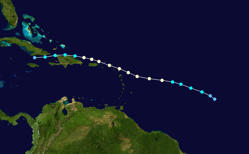
mgpetre wrote:Question: Why is this moving almost due West while all of the storms preceding it are heading almost due North or NNW? Is it because more of it's energy is lower in the atmosphere? I'm just trying to understand this whole steering thing a little better. Thanks in advance.
Aric Dunn wrote:
debbie is the best example i call it the tether ball effect
but yeah debbie got stuck on the mountains just sort of wrapped around like a tether ball
debbie was moving Wnw then all of a sudden w then wsw
so i guess anything is possible with 99l lol
Users browsing this forum: No registered users and 262 guests


