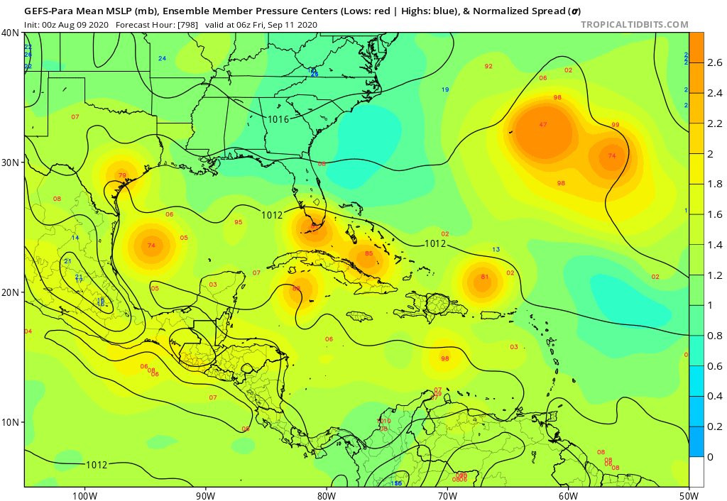
Is 16 days not enough? Levi now has the GFS Parallel run out to 35 days (840 hrs). So far, he's only run it for the 00Z August 9th model period. Interesting how the GFS is predicting below-normal pressures across most of the basin, with the Bermuda high over the Azores in September.
https://www.tropicaltidbits.com/analysis/models/?model=gfs-ens-para®ion=atl&pkg=mslpa&runtime=2020080900&fh=690
2020 Global Model Runs Discussion (Out thru day 16)
Moderator: S2k Moderators
Forum rules

The posts in this forum are NOT official forecasts and should not be used as such. They are just the opinion of the poster and may or may not be backed by sound meteorological data. They are NOT endorsed by any professional institution or STORM2K. For official information, please refer to products from the National Hurricane Center and National Weather Service.

Re: 2020 Global Model Runs Discussion (Out thru day 16)
tarheelprogrammer wrote:gatorcane wrote:The GFS continues to show hostile conditions across the Atlantic over the full 384 hours (Aug 26th), a lot of dry air and shear. Meanwhile over in the EPAC it shows 4 named storms and 1 major hurricane.
If by the end of the week there is nothing being shown on the models, it may be time to start questioning hyper activity in the Atlantic.
I'm not sure I trust the global models. If nothing is shown by them and nothing forms by the end of August, then maybe.
3 likes
Igor 2010, Sandy 2012, Fay 2014, Gonzalo 2014, Joaquin 2015, Nicole 2016, Humberto 2019, Imelda 2025
I am only a tropical weather enthusiast. My predictions are not official and may or may not be backed by sound meteorological data. For official information, please refer to the NHC and NWS products.
I am only a tropical weather enthusiast. My predictions are not official and may or may not be backed by sound meteorological data. For official information, please refer to the NHC and NWS products.
-
AxaltaRacing24
- Category 5

- Posts: 1774
- Age: 25
- Joined: Wed Jul 27, 2016 11:14 am
- Location: Jupiter, FL
Re: 2020 Global Model Runs Discussion (Out thru day 16)
tarheelprogrammer wrote:gatorcane wrote:The GFS continues to show hostile conditions across the Atlantic over the full 384 hours (Aug 26th), a lot of dry air and shear. Meanwhile over in the EPAC it shows 4 named storms and 1 major hurricane.
If by the end of the week there is nothing being shown on the models, it may be time to start questioning hyper activity in the Atlantic.
let's try to not make the same mistakes that we made on august 10th, 2017 with this.
conditions are more favorable than that season, and people still tried to cancel it in mid august.
despite what the models currently show, extremely favorable conditions will most likely arrive in the atlantic in mid/late august, and we are going to see storms.
5 likes
-
EquusStorm
- Category 5
- Posts: 1649
- Age: 35
- Joined: Thu Nov 07, 2013 1:04 pm
- Location: Jasper, AL
- Contact:
Re: 2020 Global Model Runs Discussion (Out thru day 16)
GFS literally said the same exact thing at the beginning of July though with numerous EPac hurricanes and was wrong in both basins, with just struggling slop (and phenomenally impressive Douglas) in the EPac and record-tying activity and two US hurricane landfalls in the Atlantic... EPac will probably steal the show this month indeed but relying strictly on the GFS this year has thus far been a lot of strike-outs. I truly hope it (and all the other globals) has a better handle on things now and is closer to what actually occurs because if it busts August too it might be back to the drawing board with it.
I'm honestly not even model watching much right now with how poorly everything did with Hanna and Gonzalo
I'm honestly not even model watching much right now with how poorly everything did with Hanna and Gonzalo
2 likes
Colors of lost purpose on the canvas of irrelevance
Not a meteorologist, in fact more of an idiot than anything. You should probably check with the NHC or a local NWS office for official information.
Not a meteorologist, in fact more of an idiot than anything. You should probably check with the NHC or a local NWS office for official information.
-
SFLcane

- S2K Supporter

- Posts: 10281
- Age: 48
- Joined: Sat Jun 05, 2010 1:44 pm
- Location: Lake Worth Florida
Re: 2020 Global Model Runs Discussion (Out thru day 16)
tarheelprogrammer wrote:gatorcane wrote:The GFS continues to show hostile conditions across the Atlantic over the full 384 hours (Aug 26th), a lot of dry air and shear. Meanwhile over in the EPAC it shows 4 named storms and 1 major hurricane.
If by the end of the week there is nothing being shown on the models, it may be time to start questioning hyper activity in the Atlantic.
Really should not see much in the Atlantic until after the MJO passage. Late August at the earliest
0 likes
-
AnnularCane

- S2K Supporter
- Posts: 2964
- Joined: Thu Jun 08, 2006 9:18 am
- Location: Wytheville, VA
Re: 2020 Global Model Runs Discussion (Out thru day 16)
NDG wrote:August 10, 2017 otowntiger wrote:Hammy wrote:Euro went back to showing absolutely nothing for the full run.
Might be on to something. I think it looks like August will be well below normal.Kingarabian wrote:Development is currently favored in the EPac by the models. So I would assume that will intermittently cease Atlantic activity until favorable conditions shift back towards the Atlantic.
viewtopic.php?f=31&t=118543&start=1160
There's an interesting post on that link, stating that the GFS was showing nothing through August 26 (2017). Isn't that around when Harvey made landfall?
5 likes
-
gatorcane

- S2K Supporter
- Posts: 23708
- Age: 48
- Joined: Sun Mar 13, 2005 3:54 pm
- Location: Boca Raton, FL
Re: 2020 Global Model Runs Discussion (Out thru day 16)
wxman57 wrote:Is 16 days not enough? Levi now has the GFS Parallel run out to 35 days (840 hrs). So far, he's only run it for the 00Z August 9th model period. Interesting how the GFS is predicting below-normal pressures across most of the basin, with the Bermuda high over the Azores in September.
https://www.tropicaltidbits.com/analysis/models/?model=gfs-ens-para®ion=atl&pkg=mslpa&runtime=2020080900&fh=690
Thanks for sharing. Should add for some good fodder in the indicators thread
0 likes
-
WeatherHoon
- Tropical Storm

- Posts: 131
- Joined: Sat Oct 01, 2016 6:12 am
Re: 2020 Global Model Runs Discussion (Out thru day 16)
AnnularCane wrote:NDG wrote:August 10, 2017otowntiger wrote:Might be on to something. I think it looks like August will be well below normal.Kingarabian wrote:Development is currently favored in the EPac by the models. So I would assume that will intermittently cease Atlantic activity until favorable conditions shift back towards the Atlantic.
viewtopic.php?f=31&t=118543&start=1160
There's an interesting post on that link, stating that the GFS was showing nothing through August 26 (2017). Isn't that around when Harvey made landfall?
Yes. The current talk in here is almost premonitory.
3 likes
-
WeatherEmperor
- S2K Supporter
- Posts: 4806
- Age: 42
- Joined: Thu Sep 04, 2003 2:54 pm
- Location: South Florida
Re: 2020 Global Model Runs Discussion (Out thru day 16)
I have a general question about global models...more specifically the GFS. The GFS has a 13km resolution. The Euro's is at 9km and the Ukmet's is at 10km. Why won't the National Weather Service just find a way to increase the GFS's resolution to 10km for example and do away with the high resolution hurricane models (Hmon and Hwrf)?? Why are they so hell bent on keeping the GFS the way it is and forcing the use of Hmon and Hwrf if the Euro and Ukmet are better performing??
Sent from my iPhone using Tapatalk
Sent from my iPhone using Tapatalk
0 likes
-
USTropics
- Professional-Met

- Posts: 2739
- Joined: Sun Aug 12, 2007 3:45 am
- Location: Florida State University
Re: 2020 Global Model Runs Discussion (Out thru day 16)
WeatherEmperor wrote:I have a general question about global models...more specifically the GFS. The GFS has a 13km resolution. The Euro's is at 9km and the Ukmet's is at 10km. Why won't the National Weather Service just find a way to increase the GFS's resolution to 10km for example and do away with the high resolution hurricane models (Hmon and Hwrf)?? Why are they so hell bent on keeping the GFS the way it is and forcing the use of Hmon and Hwrf if the Euro and Ukmet are better performing??
Sent from my iPhone using Tapatalk
HWRF/HMON are really intensity models, there resolutions are set to handle mesoscale processes. This is something NONE of the global models are capable of doing currently and requires ~4km resolution globally. Instead global models use approximation derived simulations on how individual thunderstorms behave, or often referred to as convective parameterization. The GFS upgrade in 2019 increased the resolution to 9km (after NWS increased processing power from 5.78 petaflops to 8.4 petaflops in 2018). There also were considerable resources provided for the Flow-following, finite-volume icosahedral model (or FIM). This was abandoned in 2016 however after it failed to show any substantial skill over the operational GFS model.
2 likes
Re: 2020 Global Model Runs Discussion (Out thru day 16)
tarheelprogrammer wrote:gatorcane wrote:The GFS continues to show hostile conditions across the Atlantic over the full 384 hours (Aug 26th), a lot of dry air and shear. Meanwhile over in the EPAC it shows 4 named storms and 1 major hurricane.
If by the end of the week there is nothing being shown on the models, it may be time to start questioning hyper activity in the Atlantic.
If tropical genesis were up to the models only, we'd still be on the A or B storm this year
4 likes
Re: 2020 Global Model Runs Discussion (Out thru day 16)
wxman57 wrote:Is 16 days not enough? Levi now has the GFS Parallel run out to 35 days (840 hrs). So far, he's only run it for the 00Z August 9th model period. Interesting how the GFS is predicting below-normal pressures across most of the basin, with the Bermuda high over the Azores in September.
https://www.tropicaltidbits.com/analysis/models/?model=gfs-ens-para®ion=atl&pkg=mslpa&runtime=2020080900&fh=690
Direct hurricane strike to Key West on day 34.
Buy or sell?
0 likes
-
AutoPenalti
- Category 5
- Posts: 4091
- Age: 29
- Joined: Mon Aug 17, 2015 4:16 pm
- Location: Ft. Lauderdale, Florida
Re: 2020 Global Model Runs Discussion (Out thru day 16)
If anything it’s showing some subtropical development at hr 804. 
0 likes
The posts in this forum are NOT official forecasts and should not be used as such. They are just the opinion of the poster and may or may not be backed by sound meteorological data. They are NOT endorsed by any professional institution or STORM2K. For official information, please refer to products from the NHC and NWS.
Model Runs Cheat Sheet:
GFS (5:30 AM/PM, 11:30 AM/PM)
HWRF, GFDL, UKMET, NAVGEM (6:30-8:00 AM/PM, 12:30-2:00 AM/PM)
ECMWF (1:45 AM/PM)
TCVN is a weighted averaged
-
lsuhurricane
- Category 1

- Posts: 270
- Joined: Tue Aug 15, 2017 2:53 pm
Re: 2020 Global Model Runs Discussion (Out thru day 16)
And just like that Euro Ensembles come to life just within the 240 hr mark. Plenty of AEW development rolling off the African Coast heading west. Additional BOC development beyond that timeframe as well.
6 likes
Re: 2020 Global Model Runs Discussion (Out thru day 16)
lsuhurricane wrote:And just like that Euro Ensembles come to life just within the 240 hr mark. Plenty of AEW development rolling off the African Coast heading west. Additional BOC development beyond that timeframe as well.
and that would match quite nicely with the standard 8-20 bell ring and expected favorable conditions heading into the atlantic. 8-20 to 8-25 is a good target range for activity.
0 likes
-
WeatherEmperor
- S2K Supporter
- Posts: 4806
- Age: 42
- Joined: Thu Sep 04, 2003 2:54 pm
- Location: South Florida
Re: 2020 Global Model Runs Discussion (Out thru day 16)
USTropics wrote:WeatherEmperor wrote:I have a general question about global models...more specifically the GFS. The GFS has a 13km resolution. The Euro's is at 9km and the Ukmet's is at 10km. Why won't the National Weather Service just find a way to increase the GFS's resolution to 10km for example and do away with the high resolution hurricane models (Hmon and Hwrf)?? Why are they so hell bent on keeping the GFS the way it is and forcing the use of Hmon and Hwrf if the Euro and Ukmet are better performing??
Sent from my iPhone using Tapatalk
HWRF/HMON are really intensity models, there resolutions are set to handle mesoscale processes. This is something NONE of the global models are capable of doing currently and requires ~4km resolution globally. Instead global models use approximation derived simulations on how individual thunderstorms behave, or often referred to as convective parameterization. The GFS upgrade in 2019 increased the resolution to 9km (after NWS increased processing power from 5.78 petaflops to 8.4 petaflops in 2018). There also were considerable resources provided for the Flow-following, finite-volume icosahedral model (or FIM). This was abandoned in 2016 however after it failed to show any substantial skill over the operational GFS model.
Thats a great explanation. Thanks very much
Sent from my iPhone using Tapatalk
0 likes
-
wxman57

- Moderator-Pro Met

- Posts: 23175
- Age: 68
- Joined: Sat Jun 21, 2003 8:06 pm
- Location: Houston, TX (southwest)
Re: 2020 Global Model Runs Discussion (Out thru day 16)
gatorcane wrote:wxman57 wrote:Is 16 days not enough? Levi now has the GFS Parallel run out to 35 days (840 hrs). So far, he's only run it for the 00Z August 9th model period. Interesting how the GFS is predicting below-normal pressures across most of the basin, with the Bermuda high over the Azores in September.
https://www.tropicaltidbits.com/analysis/models/?model=gfs-ens-para®ion=atl&pkg=mslpa&runtime=2020080900&fh=690
Thanks for sharing. Should add for some good fodder in the indicators thread
Maybe. Levi is only processing the data occasionally, and they're ensembles, so no specifics like forecasts of development.
0 likes

Re: 2020 Global Model Runs Discussion (Out thru day 16)
According to the 8/11 GFS maps on Dr. Ventrice's site, it looks like we're on the edge of Phase 5 and just about in Phase 6 of the MJO. I figured we might cross through the circle, but there was a chance we'd clip the corner of the 1/8th triangle. GFS on this run gets to Phase 8 by the 14th. We won't be able to see how the NCEP plots the GFS until tomorrow around noon, so whether it is adjusting to what the ECMWF, CMC and CFS were showing yet (getting to 1 or 2) or not remains to be seen.
Also the Week 2 forecast (8/19 - 8/25) has slightly adjusted to closer to Central America. It's still biased to the EPAC but less so than the last couple of days. Reiterating my post from last night, I'd like to see what it's doing by the end of the week.
http://mikeventrice.weebly.com/mjo.html
Also the Week 2 forecast (8/19 - 8/25) has slightly adjusted to closer to Central America. It's still biased to the EPAC but less so than the last couple of days. Reiterating my post from last night, I'd like to see what it's doing by the end of the week.
http://mikeventrice.weebly.com/mjo.html
0 likes
Re: 2020 Global Model Runs Discussion (Out thru day 16)
iCON shows about 4 storms/spins in the EPAC but doesn't get any of them particularly strong except possibly the one that heads for the CPAC. It's only out to Hour 135 right now, so that's almost 5 1/2 days (Saturday am).
https://www.tropicaltidbits.com/analysi ... 1100&fh=15
https://www.tropicaltidbits.com/analysi ... 1100&fh=15
0 likes
Who is online
Users browsing this forum: Majestic-12 [Bot] and 213 guests