https://twitter.com/DerekOrtt/status/1694031471122526547
2023 Global Model Runs Discussion (Out thru day 16)
Moderator: S2k Moderators
Forum rules

The posts in this forum are NOT official forecasts and should not be used as such. They are just the opinion of the poster and may or may not be backed by sound meteorological data. They are NOT endorsed by any professional institution or STORM2K. For official information, please refer to products from the National Hurricane Center and National Weather Service.
-
cycloneye

- Admin

- Posts: 149727
- Age: 69
- Joined: Thu Oct 10, 2002 10:54 am
- Location: San Juan, Puerto Rico
Re: 2023 Global Model Runs Discussion (Out thru day 16)
Wow, GFS for comedy only.
0 likes
Visit the Caribbean-Central America Weather Thread where you can find at first post web cams,radars
and observations from Caribbean basin members Click Here
and observations from Caribbean basin members Click Here
Re: 2023 Global Model Runs Discussion (Out thru day 16)
The GFS has been on both extremes. In some cases, it has had phantoms with 20+ in a row TCGs for something that never materialized. In other cases, it has missed TCG like with Harold.
1 likes
Personal Forecast Disclaimer:
The posts in this forum are NOT official forecasts and should not be used as such. They are just the opinion of the poster and may or may not be backed by sound meteorological data. They are NOT endorsed by any professional institution or storm2k.org. For official information, please refer to the NHC and NWS products.
The posts in this forum are NOT official forecasts and should not be used as such. They are just the opinion of the poster and may or may not be backed by sound meteorological data. They are NOT endorsed by any professional institution or storm2k.org. For official information, please refer to the NHC and NWS products.
-
ThunderForce

- Tropical Storm

- Posts: 208
- Age: 26
- Joined: Tue Sep 27, 2022 6:20 pm
- Location: Calhoun County, Florida
Re: 2023 Global Model Runs Discussion (Out thru day 16)
Although the GFS 12z operational run still shows pretty much nothing, there's a very noticeable uptick in the 12z GEFS ensembles compared to 06z.


0 likes
Please refer to the NWS, NHC, SPC or a professional meteorologist for information and decision making during storms.
-
SFLcane

- S2K Supporter

- Posts: 10281
- Age: 48
- Joined: Sat Jun 05, 2010 1:44 pm
- Location: Lake Worth Florida
Re: 2023 Global Model Runs Discussion (Out thru day 16)
Ok so wait this one just has me scratching me head how can this be possible lol or was it just luck? Either way wow. Luis feel free to move if not appropriate for this thread.
This was posted by one of my local mets here in West Palm Beach Florida back in March.
They just posted this on there facebook page.
South Texas is one area we highlighted as a potential landfall location... and today, Tropical Storm Harold made landfall there.
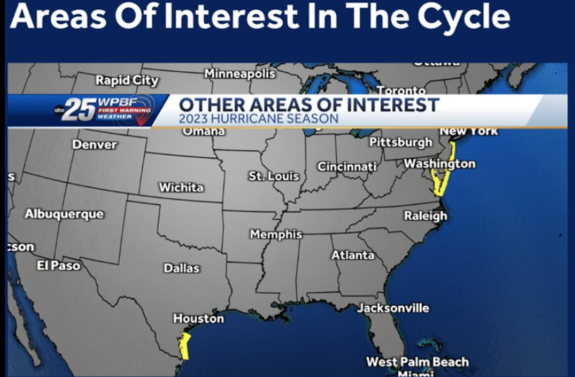
Look what they have for september? Better start my preps i guess
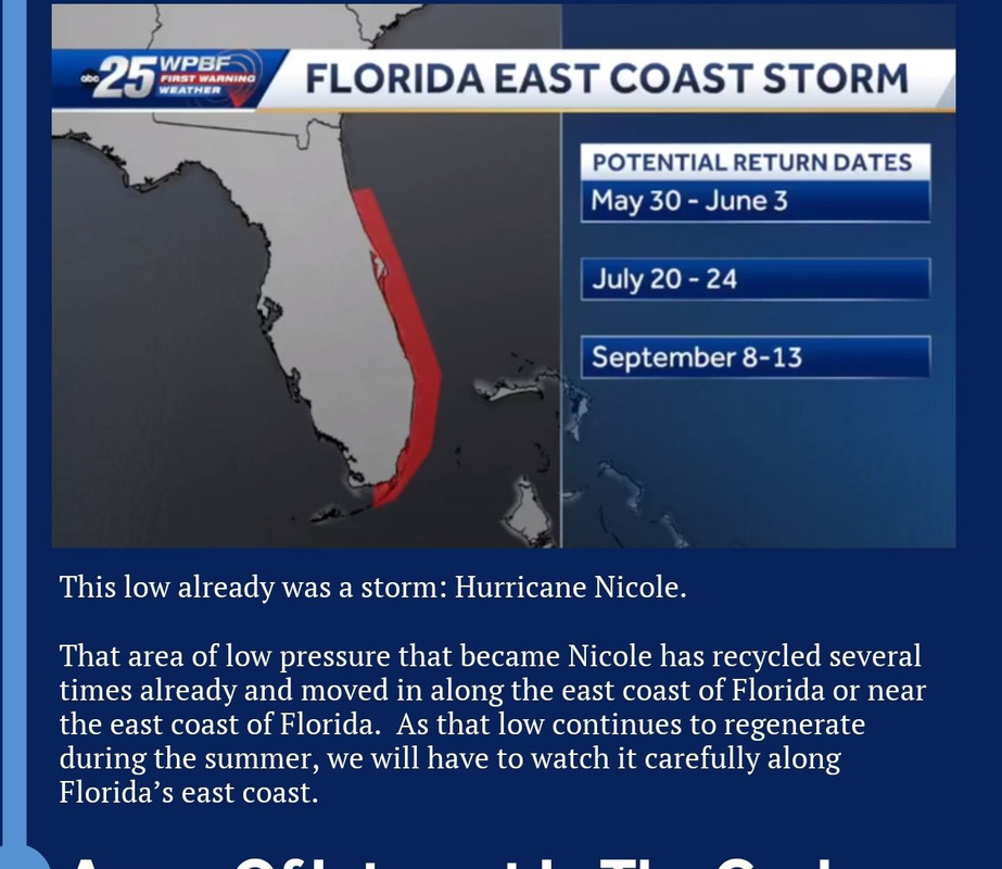
https://www.wpbf.com/article/hurricane- ... NOcb8Aoexk
This was posted by one of my local mets here in West Palm Beach Florida back in March.
They just posted this on there facebook page.
South Texas is one area we highlighted as a potential landfall location... and today, Tropical Storm Harold made landfall there.
Look what they have for september? Better start my preps i guess
https://www.wpbf.com/article/hurricane- ... NOcb8Aoexk
1 likes
Re: 2023 Global Model Runs Discussion (Out thru day 16)
SFLcane wrote:Ok so wait this one just has me scratching me head how can this be possible lol or was it just luck? Either way wow. Luis feel free to move if not appropriate for this thread.
This was posted by one of my local mets here in West Palm Beach Florida back in March.
They just posted this on there facebook page.
South Texas is one area we highlighted as a potential landfall location... and today, Tropical Storm Harold made landfall there.
https://i.postimg.cc/NGZyQKsv/hhhh.png
Look what they have for september? Better start my preps i guess
https://i.postimg.cc/hGG4LnD0/ghghghg.jpg
https://www.wpbf.com/article/hurricane- ... NOcb8Aoexk
That is the Lezak Recurring Cycle right? It is intriguing but I am still pretty skeptical of it.
0 likes
-
SFLcane
- S2K Supporter
- Posts: 10281
- Age: 48
- Joined: Sat Jun 05, 2010 1:44 pm
- Location: Lake Worth Florida
Re: 2023 Global Model Runs Discussion (Out thru day 16)
IcyTundra wrote:SFLcane wrote:Ok so wait this one just has me scratching me head how can this be possible lol or was it just luck? Either way wow. Luis feel free to move if not appropriate for this thread.
This was posted by one of my local mets here in West Palm Beach Florida back in March.
They just posted this on there facebook page.
South Texas is one area we highlighted as a potential landfall location... and today, Tropical Storm Harold made landfall there.
https://i.postimg.cc/NGZyQKsv/hhhh.png
Look what they have for september? Better start my preps i guess
https://i.postimg.cc/hGG4LnD0/ghghghg.jpg
https://www.wpbf.com/article/hurricane- ... NOcb8Aoexk
That is the Lezak Recurring Cycle right? It is intriguing but I am still pretty skeptical of it.
They might get west coast fl/panhandle for august.
0 likes
-
SFLcane
- S2K Supporter
- Posts: 10281
- Age: 48
- Joined: Sat Jun 05, 2010 1:44 pm
- Location: Lake Worth Florida
Re: 2023 Global Model Runs Discussion (Out thru day 16)
All in all i dont buy into any of it.
3 likes
-
jlauderdal
- S2K Supporter
- Posts: 7240
- Joined: Wed May 19, 2004 5:46 am
- Location: NE Fort Lauderdale
- Contact:
Re: 2023 Global Model Runs Discussion (Out thru day 16)
SFLcane wrote:jlauderdal wrote:N2FSU wrote:0z Euro ensembles jumping on a storm moving into the northern Gulf next week as well: https://uploads.tapatalk-cdn.com/20230822/31bad4422f4216156e726debe8294098.jpeg
https://uploads.tapatalk-cdn.com/20230822/67cbc4f7cba081887342d13941b4872e.jpeg
Sent from my iPhone using Tapatalk
The euro had a very intense panhandle system a couple of days ago, then lost it, and now it's back with model support, it looks like we have our first big player of the season. Meanwhile, we continue to dodge systems in SE Florida...harry to the west, frank to the se and now this gulf system to the west.
What are we dodging if nothing has formed yet?
If it's not in SE Florida and not coming here, we dodged it and have been for many many years.
0 likes
-
TomballEd
- Category 5

- Posts: 1322
- Age: 62
- Joined: Wed Aug 16, 2023 4:52 pm
- Location: Spring/Klein area, not Tomball
Re: 2023 Global Model Runs Discussion (Out thru day 16)
jlauderdal wrote:SFLcane wrote:jlauderdal wrote:The euro had a very intense panhandle system a couple of days ago, then lost it, and now it's back with model support, it looks like we have our first big player of the season. Meanwhile, we continue to dodge systems in SE Florida...harry to the west, frank to the se and now this gulf system to the west.
What are we dodging if nothing has formed yet?
If it's not in SE Florida and not coming here, we dodged it and have been for many many years.I start the generator once a month year-round, so far, so good.
The return frequency for big storms here is 25 or 30 years. I've taught probability, I realize 'due' isn't really a thing. But we got another 10 to 15 years. We're good this year, the death ridge that drove Harold straight W will continue doing that for another week, then the ridge retreats back to the W, we get on the backside of the trough, and N (offshore) winds protect us. Next year, maybe 10 years comes early. But SE Florida is due, even if due isn't a sound concept.
1 likes
-
jlauderdal
- S2K Supporter
- Posts: 7240
- Joined: Wed May 19, 2004 5:46 am
- Location: NE Fort Lauderdale
- Contact:
Re: 2023 Global Model Runs Discussion (Out thru day 16)
TomballEd wrote:jlauderdal wrote:SFLcane wrote:
What are we dodging if nothing has formed yet?
If it's not in SE Florida and not coming here, we dodged it and have been for many many years.
The return frequency for big storms here is 25 or 30 years. I've taught probability, I realize 'due' isn't really a thing. But we got another 10 to 15 years. We're good this year, the death ridge that drove Harold straight W will continue doing that for another week, then the ridge retreats back to the W, we get on the backside of the trough, and N (offshore) winds protect us. Next year, maybe 10 years comes early. But SE Florida is due, even if due isn't a sound concept.
I ilke your plan, not sure if mother nature will execute....October is prime time for Florida as you know.
3 likes
-
SFLcane
- S2K Supporter
- Posts: 10281
- Age: 48
- Joined: Sat Jun 05, 2010 1:44 pm
- Location: Lake Worth Florida
Re: 2023 Global Model Runs Discussion (Out thru day 16)
Still have faith for this season just want to see some model consistency instead of it lasting for 1 run.
3 likes
-
CFLHurricane

- Category 1

- Posts: 350
- Joined: Thu Mar 27, 2014 5:56 pm
- Location: Floriduh
Re: 2023 Global Model Runs Discussion (Out thru day 16)
SFLcane wrote:Still have faith for this season just want to see some model consistency instead of it lasting for 1 run.
Yup, this model pattern is a sigh of relief for many a Floridian as we head into peak season. However, I fear our fortunes may turn in October with gyres heading northward our way.
0 likes
I'm not a meteorologist, but I did stay at a motel 8.
Re: 2023 Global Model Runs Discussion (Out thru day 16)
TomballEd wrote:jlauderdal wrote:SFLcane wrote:
What are we dodging if nothing has formed yet?
If it's not in SE Florida and not coming here, we dodged it and have been for many many years.
The return frequency for big storms here is 25 or 30 years. I've taught probability, I realize 'due' isn't really a thing. But we got another 10 to 15 years. We're good this year, the death ridge that drove Harold straight W will continue doing that for another week, then the ridge retreats back to the W, we get on the backside of the trough, and N (offshore) winds protect us. Next year, maybe 10 years comes early. But SE Florida is due, even if due isn't a sound concept.
I don't think it works that way. The weather pattern is always fluid. And it's just a matter of right place, right time. Or wrong place, wrong time
3 likes
-
SouthFLTropics

- Category 5
- Posts: 4258
- Age: 50
- Joined: Thu Aug 14, 2003 8:04 am
- Location: Port St. Lucie, Florida
Re: 2023 Global Model Runs Discussion (Out thru day 16)
Surprised no one has posted the 00z CMC. Sends a 979mb storm right up Tampa Bay in 168 hours. Looks to develop from the EPac crossover.
Sent from my iPhone using Tapatalk
Sent from my iPhone using Tapatalk
4 likes
Fourth Generation Florida Native
Personal Storm History: David 79, Andrew 92, Erin 95, Floyd 99, Irene 99, Frances 04, Jeanne 04, Wilma 05, Matthew 16, Irma 17, Ian 22, Nicole 22, Milton 24
Personal Storm History: David 79, Andrew 92, Erin 95, Floyd 99, Irene 99, Frances 04, Jeanne 04, Wilma 05, Matthew 16, Irma 17, Ian 22, Nicole 22, Milton 24
-
SouthFLTropics
- Category 5
- Posts: 4258
- Age: 50
- Joined: Thu Aug 14, 2003 8:04 am
- Location: Port St. Lucie, Florida
Re: 2023 Global Model Runs Discussion (Out thru day 16)
SouthFLTropics wrote:Surprised no one has posted the 00z CMC. Sends a 979mb storm right up Tampa Bay in 168 hours. Looks to develop from the EPac crossover.
Sent from my iPhone using Tapatalk
00z Icon appears to have something crossing SW FL also, albeit weaker.
Sent from my iPhone using Tapatalk
1 likes
Fourth Generation Florida Native
Personal Storm History: David 79, Andrew 92, Erin 95, Floyd 99, Irene 99, Frances 04, Jeanne 04, Wilma 05, Matthew 16, Irma 17, Ian 22, Nicole 22, Milton 24
Personal Storm History: David 79, Andrew 92, Erin 95, Floyd 99, Irene 99, Frances 04, Jeanne 04, Wilma 05, Matthew 16, Irma 17, Ian 22, Nicole 22, Milton 24
Re: 2023 Global Model Runs Discussion (Out thru day 16)
SouthFLTropics wrote:Surprised no one has posted the 00z CMC. Sends a 979mb storm right up Tampa Bay in 168 hours. Looks to develop from the EPac crossover.
This is just 7 days out, 12z run had something near here too, just not anywhere near as organized. GFS does have something move over central america but it remains disorganized too. 12Z euro also had something around here in a week. I guess this will be the area to watch over the next few days for damn sure (besides Franklin and Bermuda) Models really depend on how/where this pops out at on the Atlantic side. West Caribbean here in the Canadian. GFS destroys it over Central America and never really recovers it, Euro is somewhere in between. (18z has it in over Belize)
I.e. watch this on Friday.

Last edited by BobHarlem on Tue Aug 22, 2023 11:39 pm, edited 4 times in total.
0 likes
-
SouthFLTropics
- Category 5
- Posts: 4258
- Age: 50
- Joined: Thu Aug 14, 2003 8:04 am
- Location: Port St. Lucie, Florida
Re: 2023 Global Model Runs Discussion (Out thru day 16)
On closer look there, it appears to hit south of Tampa Bay. More like Sarasota or Bradenton.
Sent from my iPhone using Tapatalk
Sent from my iPhone using Tapatalk
0 likes
Fourth Generation Florida Native
Personal Storm History: David 79, Andrew 92, Erin 95, Floyd 99, Irene 99, Frances 04, Jeanne 04, Wilma 05, Matthew 16, Irma 17, Ian 22, Nicole 22, Milton 24
Personal Storm History: David 79, Andrew 92, Erin 95, Floyd 99, Irene 99, Frances 04, Jeanne 04, Wilma 05, Matthew 16, Irma 17, Ian 22, Nicole 22, Milton 24

Re: 2023 Global Model Runs Discussion (Out thru day 16)
SouthFLTropics wrote:Surprised no one has posted the 00z CMC. Sends a 979mb storm right up Tampa Bay in 168 hours. Looks to develop from the EPac crossover.
I was walking one of my dogs and brushing my teeth. CMC in the house with the big dog and biggest hit so far this year. CMC has gotten much better but it’s still the crazy email forwarding uncle. So wait for support IMHO
1 likes
Re: 2023 Global Model Runs Discussion (Out thru day 16)
Steve wrote:SouthFLTropics wrote:Surprised no one has posted the 00z CMC. Sends a 979mb storm right up Tampa Bay in 168 hours. Looks to develop from the EPac crossover.
I was walking one of my dogs and brushing my teeth. CMC in the house with the big dog and biggest hit so far this year. CMC has gotten much better but it’s still the crazy email forwarding uncle. So wait for support IMHO
Looks more like around Venice maybe. That's about a 100mph storm. If the Gulf waters are still 90 degrees IMO that's going to be stronger than that! Looks small in size so surge wise just like Charley that could be a saver there. Otherwise if it's large like Ian that surge will go right up Charlotte Harbor on that track.
0 likes
Who is online
Users browsing this forum: South Texas Storms and 183 guests