2025 Global Model Runs Discussion (Out thru day 16)

This is the general tropical discussion area. Anyone can take their shot at predicting a storms path.

Moderator: S2k Moderators

Forum rules

The posts in this forum are NOT official forecasts and should not be used as such. They are just the opinion of the poster and may or may not be backed by sound meteorological data. They are NOT endorsed by any professional institution or STORM2K. For official information, please refer to products from the National Hurricane Center and National Weather Service.

Help Support Storm2K
Message
Author
LarryWx
S2K Supporter
S2K Supporter
Posts: 6747
Joined: Sun Sep 07, 2003 2:04 pm
Location: GA

Re: 2025 Global Model Runs Discussion (Out thru day 16)

#1201 Postby LarryWx » Sun Oct 05, 2025 11:14 pm

0Z UKMET has a TD in the E MDR for 1st time with it moving WNW at a brisk pace:

NEW TROPICAL CYCLONE FORECAST TO DEVELOP AFTER 132 HOURS
FORECAST POSITION AT T+132 : 9.8N 23.6W

LEAD CENTRAL MAXIMUM WIND
VERIFYING TIME TIME POSITION PRESSURE (MB) SPEED (KNOTS)
-------------- ---- -------- ------------- -------------
1200UTC 11.10.2025 132 9.8N 23.6W 1009 31
0000UTC 12.10.2025 144 10.5N 27.6W 1009 32
1200UTC 12.10.2025 156 10.7N 30.9W 1009 26
0000UTC 13.10.2025 168 11.8N 34.8W 1009 26
0 likes   
Personal Forecast Disclaimer:
The posts in this forum are NOT official forecasts and should not be used as such. They are just the opinion of the poster and may or may not be backed by sound meteorological data. They are NOT endorsed by any professional institution or storm2k.org. For official information, please refer to the NHC and NWS products.

caneman
Category 5
Category 5
Posts: 1473
Joined: Fri Sep 05, 2014 5:44 am
Location: Clearwater Beach, Fl

Re: 2025 Global Model Runs Discussion (Out thru day 16)

#1202 Postby caneman » Mon Oct 06, 2025 6:24 am


Did long range models drop the gulf system?
0 likes   

User avatar
SFLcane
S2K Supporter
S2K Supporter
Posts: 10223
Age: 47
Joined: Sat Jun 05, 2010 1:44 pm
Location: Lake Worth Florida

Re: 2025 Global Model Runs Discussion (Out thru day 16)

#1203 Postby SFLcane » Mon Oct 06, 2025 9:04 am

caneman wrote:


Did long range models drop the gulf system?


I would not say gulf system moreso caribbean and florida and out just based on climo. The signal has not been consistent just on and off for now. I would be surprised if something does not form it looks pretty favorable especially in about a week or two whether its slop or a major hurricane is anyones guess. Its certainly possible models will pick up on something in the CAG as the MJO moves in we will see.

Image
3 likes   

Fancy1002
Tropical Storm
Tropical Storm
Posts: 210
Joined: Sun Dec 25, 2022 3:47 pm

Re: 2025 Global Model Runs Discussion (Out thru day 16)

#1204 Postby Fancy1002 » Mon Oct 06, 2025 11:19 am

Why is no one talking about the apparent tropical storm riding up the East Coast on most models in the next few days?
1 likes   

User avatar
ConvergenceZone
Category 5
Category 5
Posts: 5238
Joined: Fri Jul 29, 2005 1:40 am
Location: Northern California

Re: 2025 Global Model Runs Discussion (Out thru day 16)

#1205 Postby ConvergenceZone » Mon Oct 06, 2025 11:40 am

Fancy1002 wrote:Why is no one talking about the apparent tropical storm riding up the East Coast on most models in the next few days?


I think people are just in Winter mode already and giving up on the tropics until next year. Plus the models have been very inconsistent this year so far.
3 likes   

User avatar
AnnularCane
S2K Supporter
S2K Supporter
Posts: 2934
Joined: Thu Jun 08, 2006 9:18 am
Location: Wytheville, VA

Re: 2025 Global Model Runs Discussion (Out thru day 16)

#1206 Postby AnnularCane » Mon Oct 06, 2025 11:59 am

Fancy1002 wrote:Why is no one talking about the apparent tropical storm riding up the East Coast on most models in the next few days?


I've seen some call it a nor'easter. Not sure how they tell the difference but I'm not going to argue at this point. :craz:
2 likes   
"But it never rained rain. It never snowed snow. And it never blew just wind. It rained things like soup and juice. It snowed mashed potatoes and green peas. And sometimes the wind blew in storms of hamburgers." -- Judi Barrett, Cloudy with a Chance of Meatballs

LarryWx
S2K Supporter
S2K Supporter
Posts: 6747
Joined: Sun Sep 07, 2003 2:04 pm
Location: GA

Re: 2025 Global Model Runs Discussion (Out thru day 16)

#1207 Postby LarryWx » Mon Oct 06, 2025 1:33 pm

AnnularCane wrote:
Fancy1002 wrote:Why is no one talking about the apparent tropical storm riding up the East Coast on most models in the next few days?


I've seen some call it a nor'easter. Not sure how they tell the difference but I'm not going to argue at this point. :craz:


It’s being called a cut-off hybrid nor’easter in all discussions I’ve seen. The reason for genesis isn’t tropical but rather it forms on a cold front/contrasting airmasses along with strong upper level energy (shortwave) diving SE into where the front is located. In contrast, tropical normally forms within a very warm and moist airmass (dewpoints of 75+ preferred) when there aren’t contrasting airmasses and they prefer an upper level high overhead. Though maybe not likely, I think it could transition into subtropical after an extratropical start. If so, it could eventually get a name (ST storm) despite not being purely tropical. But I could also see it never being called subtropical and this not getting named.

What do others think?
2 likes   
Personal Forecast Disclaimer:
The posts in this forum are NOT official forecasts and should not be used as such. They are just the opinion of the poster and may or may not be backed by sound meteorological data. They are NOT endorsed by any professional institution or storm2k.org. For official information, please refer to the NHC and NWS products.

LarryWx
S2K Supporter
S2K Supporter
Posts: 6747
Joined: Sun Sep 07, 2003 2:04 pm
Location: GA

Re: 2025 Global Model Runs Discussion (Out thru day 16)

#1208 Postby LarryWx » Mon Oct 06, 2025 2:17 pm

LarryWx wrote:0Z UKMET has a TD in the E MDR for 1st time with it moving WNW at a brisk pace:

NEW TROPICAL CYCLONE FORECAST TO DEVELOP AFTER 132 HOURS
FORECAST POSITION AT T+132 : 9.8N 23.6W

LEAD CENTRAL MAXIMUM WIND
VERIFYING TIME TIME POSITION PRESSURE (MB) SPEED (KNOTS)
-------------- ---- -------- ------------- -------------
1200UTC 11.10.2025 132 9.8N 23.6W 1009 31
0000UTC 12.10.2025 144 10.5N 27.6W 1009 32
1200UTC 12.10.2025 156 10.7N 30.9W 1009 26
0000UTC 13.10.2025 168 11.8N 34.8W 1009 26


For the 2nd run in a row, the UKMET (12Z) has a briskly moving TD in the E MDR moving WNW. I don’t currently think this is a big deal as it slowly weakens and there’s no support from other models in that location as the Icon and CMC are further E. And there’s no support from the Euro and GFS suites. But I like to post these for the record:

NEW TROPICAL CYCLONE FORECAST TO DEVELOP AFTER 108 HOURS
FORECAST POSITION AT T+108 : 8.4N 22.1W

LEAD CENTRAL MAXIMUM WIND
VERIFYING TIME TIME POSITION PRESSURE (MB) SPEED (KNOTS)
-------------- ---- -------- ------------- -------------
0000UTC 11.10.2025 108 8.4N 22.1W 1008 33
1200UTC 11.10.2025 120 8.6N 26.4W 1008 31
0000UTC 12.10.2025 132 9.3N 30.7W 1007 32
1200UTC 12.10.2025 144 10.1N 34.9W 1007 33
0000UTC 13.10.2025 156 11.4N 38.7W 1007 31
1200UTC 13.10.2025 168 12.6N 42.6W 1008 29
Last edited by LarryWx on Mon Oct 06, 2025 2:59 pm, edited 1 time in total.
0 likes   
Personal Forecast Disclaimer:
The posts in this forum are NOT official forecasts and should not be used as such. They are just the opinion of the poster and may or may not be backed by sound meteorological data. They are NOT endorsed by any professional institution or storm2k.org. For official information, please refer to the NHC and NWS products.

TomballEd
Category 5
Category 5
Posts: 1025
Age: 61
Joined: Wed Aug 16, 2023 4:52 pm
Location: Spring/Klein area, not Tomball

Re: 2025 Global Model Runs Discussion (Out thru day 16)

#1209 Postby TomballEd » Mon Oct 06, 2025 2:46 pm

GFS and Euro ensembles quite unenthusiastic about new Caribbean to BoC. Some high 1000s members, I suppose a TD isn't impossible.


More interested in a later SEUSA development with somewhat better support that could interact with 95L.

Image
1 likes   

TomballEd
Category 5
Category 5
Posts: 1025
Age: 61
Joined: Wed Aug 16, 2023 4:52 pm
Location: Spring/Klein area, not Tomball

Re: 2025 Global Model Runs Discussion (Out thru day 16)

#1210 Postby TomballEd » Mon Oct 06, 2025 5:24 pm

Op Euro sees sub-tropical development off the SEUSA.

Image
0 likes   

Fancy1002
Tropical Storm
Tropical Storm
Posts: 210
Joined: Sun Dec 25, 2022 3:47 pm

Re: 2025 Global Model Runs Discussion (Out thru day 16)

#1211 Postby Fancy1002 » Mon Oct 06, 2025 5:46 pm

TomballEd wrote:Op Euro sees sub-tropical development off the SEUSA.

https://i.imgur.com/gB0thGe.png

Different models have been showing that for days
0 likes   

TomballEd
Category 5
Category 5
Posts: 1025
Age: 61
Joined: Wed Aug 16, 2023 4:52 pm
Location: Spring/Klein area, not Tomball

Re: 2025 Global Model Runs Discussion (Out thru day 16)

#1212 Postby TomballEd » Mon Oct 06, 2025 5:59 pm

Fancy1002 wrote:
TomballEd wrote:Op Euro sees sub-tropical development off the SEUSA.

https://i.imgur.com/gB0thGe.png

Different models have been showing that for days


Maybe but other than my ensemble post about the pointless 10% lemon noting the SEUSA subtropical threat, and the post you responded to, nobody, on this page, has said anything. More posts people complaining about a boring season because there hasn't been a billion dollar disaster.
1 likes   

User avatar
DorkyMcDorkface
Category 4
Category 4
Posts: 951
Age: 27
Joined: Mon Sep 30, 2019 1:32 pm
Location: Mid-Atlantic

Re: 2025 Global Model Runs Discussion (Out thru day 16)

#1213 Postby DorkyMcDorkface » Mon Oct 06, 2025 8:32 pm

LarryWx wrote:
LarryWx wrote:0Z UKMET has a TD in the E MDR for 1st time with it moving WNW at a brisk pace:

NEW TROPICAL CYCLONE FORECAST TO DEVELOP AFTER 132 HOURS
FORECAST POSITION AT T+132 : 9.8N 23.6W

LEAD CENTRAL MAXIMUM WIND
VERIFYING TIME TIME POSITION PRESSURE (MB) SPEED (KNOTS)
-------------- ---- -------- ------------- -------------
1200UTC 11.10.2025 132 9.8N 23.6W 1009 31
0000UTC 12.10.2025 144 10.5N 27.6W 1009 32
1200UTC 12.10.2025 156 10.7N 30.9W 1009 26
0000UTC 13.10.2025 168 11.8N 34.8W 1009 26[


For the 2nd run in a row, the UKMET (12Z) has a briskly moving TD in the E MDR moving WNW.
I don’t currently think this is a big deal as it slowly weakens and there’s no support from other
models in that location as the Icon and CMC are further E. And there’s no support from the
Euro and GFS suites. But I like to post these for the record:

NEW TROPICAL CYCLONE FORECAST TO DEVELOP AFTER 108 HOURS
FORECAST POSITION AT T+108 : 8.4N 22.1W

LEAD CENTRAL MAXIMUM WIND
VERIFYING TIME TIME POSITION PRESSURE (MB) SPEED (KNOTS)
-------------- ---- -------- ------------- -------------
0000UTC 11.10.2025 108 8.4N 22.1W 1008 33
1200UTC 11.10.2025 120 8.6N 26.4W 1008 31
0000UTC 12.10.2025 132 9.3N 30.7W 1007 32
1200UTC 12.10.2025 144 10.1N 34.9W 1007 33
0000UTC 13.10.2025 156 11.4N 38.7W 1007 31
1200UTC 13.10.2025 168 12.6N 42.6W 1008 29


This is also on the CMC and ICON, and has EPS support. Nothing on the GFS yet though - we'll see if it eventually hops on board.
Image
Image
Image
1 likes   
Please note the thougths expressed by this account are solely those of the user and are from a hobbyist perspective. For more comprehensive analysis, consult an actual professional meteorologist or meteorology agency.


Floyd 1999 | Isabel 2003 | Hanna 2008 | Irene 2011 | Sandy 2012 | Isaias 2020

User avatar
Teban54
Category 5
Category 5
Posts: 3521
Joined: Sat May 19, 2018 1:19 pm

Re: 2025 Global Model Runs Discussion (Out thru day 16)

#1214 Postby Teban54 » Mon Oct 06, 2025 9:00 pm

DorkyMcDorkface wrote:
LarryWx wrote:
LarryWx wrote:0Z UKMET has a TD in the E MDR for 1st time with it moving WNW at a brisk pace:

NEW TROPICAL CYCLONE FORECAST TO DEVELOP AFTER 132 HOURS
FORECAST POSITION AT T+132 : 9.8N 23.6W

LEAD CENTRAL MAXIMUM WIND
VERIFYING TIME TIME POSITION PRESSURE (MB) SPEED (KNOTS)
-------------- ---- -------- ------------- -------------
1200UTC 11.10.2025 132 9.8N 23.6W 1009 31
0000UTC 12.10.2025 144 10.5N 27.6W 1009 32
1200UTC 12.10.2025 156 10.7N 30.9W 1009 26
0000UTC 13.10.2025 168 11.8N 34.8W 1009 26[


For the 2nd run in a row, the UKMET (12Z) has a briskly moving TD in the E MDR moving WNW.
I don’t currently think this is a big deal as it slowly weakens and there’s no support from other
models in that location as the Icon and CMC are further E. And there’s no support from the
Euro and GFS suites. But I like to post these for the record:

NEW TROPICAL CYCLONE FORECAST TO DEVELOP AFTER 108 HOURS
FORECAST POSITION AT T+108 : 8.4N 22.1W

LEAD CENTRAL MAXIMUM WIND
VERIFYING TIME TIME POSITION PRESSURE (MB) SPEED (KNOTS)
-------------- ---- -------- ------------- -------------
0000UTC 11.10.2025 108 8.4N 22.1W 1008 33
1200UTC 11.10.2025 120 8.6N 26.4W 1008 31
0000UTC 12.10.2025 132 9.3N 30.7W 1007 32
1200UTC 12.10.2025 144 10.1N 34.9W 1007 33
0000UTC 13.10.2025 156 11.4N 38.7W 1007 31
1200UTC 13.10.2025 168 12.6N 42.6W 1008 29

This is also on the CMC and ICON, and has EPS support. Nothing on the GFS yet though - we'll see if it eventually hops on board.
https://i.imgur.com/dEuaJ7B.gif
https://i.imgur.com/TFFyXow.gif
https://i.imgur.com/k6ISQ5k.png

If this happens, more storms would have formed in the MDR in October than in August. :lol:
3 likes   

User avatar
Teban54
Category 5
Category 5
Posts: 3521
Joined: Sat May 19, 2018 1:19 pm

Re: 2025 Global Model Runs Discussion (Out thru day 16)

#1215 Postby Teban54 » Tue Oct 07, 2025 9:16 am

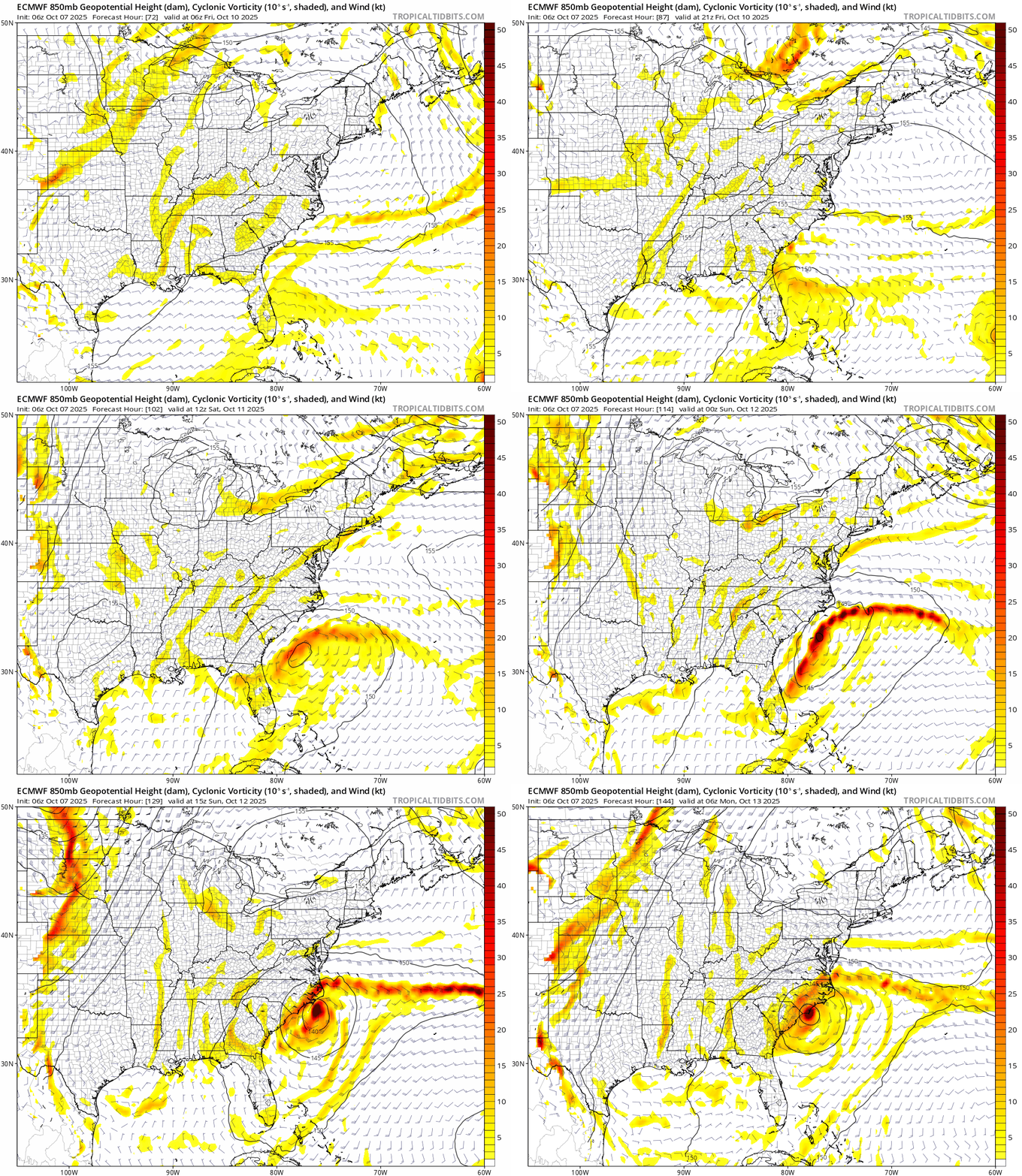
6z ECMWF continues the trend of a system just offshore the Carolinas that the model started a day ago (or even earlier). May be frontal on this run, but the 0z run shows clean separation into a tropical or subtropical storm.

This is also on other models, but generally not as strong or notable as a distinct identity. I also wonder if Euro's insistence on keeping Jerry weak played a part in it.

Image
2 likes   

User avatar
Teban54
Category 5
Category 5
Posts: 3521
Joined: Sat May 19, 2018 1:19 pm

Re: 2025 Global Model Runs Discussion (Out thru day 16)

#1216 Postby Teban54 » Tue Oct 07, 2025 10:52 am

Interesting note on Google Deep Mind in Jerry's first advisory:

The NHC track forecast is a little faster than the model consensus through 72 hours and in best agreement with HCCA and the Google Deep Mind ensemble mean, which have been performing quite well so far this year.
0 likes   

LarryWx
S2K Supporter
S2K Supporter
Posts: 6747
Joined: Sun Sep 07, 2003 2:04 pm
Location: GA

Re: 2025 Global Model Runs Discussion (Out thru day 16)

#1217 Postby LarryWx » Tue Oct 07, 2025 12:47 pm

LarryWx wrote:
LarryWx wrote:0Z UKMET has a TD in the E MDR for 1st time with it moving WNW at a brisk pace:

NEW TROPICAL CYCLONE FORECAST TO DEVELOP AFTER 132 HOURS
FORECAST POSITION AT T+132 : 9.8N 23.6W

LEAD CENTRAL MAXIMUM WIND
VERIFYING TIME TIME POSITION PRESSURE (MB) SPEED (KNOTS)
-------------- ---- -------- ------------- -------------
1200UTC 11.10.2025 132 9.8N 23.6W 1009 31
0000UTC 12.10.2025 144 10.5N 27.6W 1009 32
1200UTC 12.10.2025 156 10.7N 30.9W 1009 26
0000UTC 13.10.2025 168 11.8N 34.8W 1009 26


For the 2nd run in a row, the UKMET (12Z) has a briskly moving TD in the E MDR moving WNW. I don’t currently think this is a big deal as it slowly weakens and there’s no support from other models in that location as the Icon and CMC are further E. And there’s no support from the Euro and GFS suites. But I like to post these for the record:

NEW TROPICAL CYCLONE FORECAST TO DEVELOP AFTER 108 HOURS
FORECAST POSITION AT T+108 : 8.4N 22.1W

LEAD CENTRAL MAXIMUM WIND
VERIFYING TIME TIME POSITION PRESSURE (MB) SPEED (KNOTS)
-------------- ---- -------- ------------- -------------
0000UTC 11.10.2025 108 8.4N 22.1W 1008 33
1200UTC 11.10.2025 120 8.6N 26.4W 1008 31
0000UTC 12.10.2025 132 9.3N 30.7W 1007 32
1200UTC 12.10.2025 144 10.1N 34.9W 1007 33
0000UTC 13.10.2025 156 11.4N 38.7W 1007 31
1200UTC 13.10.2025 168 12.6N 42.6W 1008 29


After both runs of 10/6 having it and then dropping it at 0Z 10/7, 12Z 10/7 UK has it back:

NEW TROPICAL CYCLONE FORECAST TO DEVELOP AFTER 72 HOURS
FORECAST POSITION AT T+ 72 : 8.4N 16.4W

LEAD CENTRAL MAXIMUM WIND
VERIFYING TIME TIME POSITION PRESSURE (MB) SPEED (KNOTS)
-------------- ---- -------- ------------- -------------
1200UTC 10.10.2025 72 8.4N 16.4W 1009 39
0000UTC 11.10.2025 84 9.0N 21.1W 1008 35
1200UTC 11.10.2025 96 9.4N 25.1W 1007 34
0000UTC 12.10.2025 108 10.7N 29.3W 1006 40
1200UTC 12.10.2025 120 11.7N 33.3W 1008 35
0000UTC 13.10.2025 132 13.0N 36.8W 1008 35
1200UTC 13.10.2025 144 13.6N 40.1W 1009 34
0000UTC 14.10.2025 156 14.6N 42.9W 1009 30
1200UTC 14.10.2025 168 15.7N 45.7W 1010 27
0 likes   
Personal Forecast Disclaimer:
The posts in this forum are NOT official forecasts and should not be used as such. They are just the opinion of the poster and may or may not be backed by sound meteorological data. They are NOT endorsed by any professional institution or storm2k.org. For official information, please refer to the NHC and NWS products.

Fancy1002
Tropical Storm
Tropical Storm
Posts: 210
Joined: Sun Dec 25, 2022 3:47 pm

Re: 2025 Global Model Runs Discussion (Out thru day 16)

#1218 Postby Fancy1002 » Tue Oct 07, 2025 12:52 pm

Let me get this straight, if Jerry is weak and pathetic, then the south east coast needs to worry about Karen calling the manager, while if Jerry defies his name, then the northeast has to deal with her nonsense instead.
2 likes   

Fancy1002
Tropical Storm
Tropical Storm
Posts: 210
Joined: Sun Dec 25, 2022 3:47 pm

Re: 2025 Global Model Runs Discussion (Out thru day 16)

#1219 Postby Fancy1002 » Tue Oct 07, 2025 12:57 pm

I hope the one over the Yucatán doesn’t form, just so that my previous joke doesn’t age badly almost immediately.
1 likes   

User avatar
SFLcane
S2K Supporter
S2K Supporter
Posts: 10223
Age: 47
Joined: Sat Jun 05, 2010 1:44 pm
Location: Lake Worth Florida

Re: 2025 Global Model Runs Discussion (Out thru day 16)

#1220 Postby SFLcane » Tue Oct 07, 2025 1:38 pm

Whatever CAG signal there was very much down trended lots going on in the bahamas will help keep what ever tries to get going strung out it seems.
1 likes   


Return to “Talkin' Tropics”

Who is online

Users browsing this forum: Zonacane and 111 guests