
Massive meso vort over Chicago yesterday and an associated Deracho.
Over 100 mph winds recorded in Iowa.
Front is moving to the coast and will stall out over the weekend along the GoM Shore and Eastern Seaboard.
All globals showing a spin up from Friday thru Sunday.
Can be anywhere from FL Panhandle to the Outer Banks.
Stay tuned.
2020 Global Model Runs Discussion (Out thru day 16)
Moderator: S2k Moderators
Forum rules

The posts in this forum are NOT official forecasts and should not be used as such. They are just the opinion of the poster and may or may not be backed by sound meteorological data. They are NOT endorsed by any professional institution or STORM2K. For official information, please refer to products from the National Hurricane Center and National Weather Service.
Re: 2020 Global Model Runs Discussion (Out thru day 16)
00Z GFS showing the vort spread out from the FL Pandhandle to Chesapeake Bay on Sunday.
Splits it with something possibly developing in the GoM earlier next week.


Splits it with something possibly developing in the GoM earlier next week.
0 likes

Re: 2020 Global Model Runs Discussion (Out thru day 16)
There have been some interesting solutions in the most recent model runs.
For the last several days, the GFS has shown a subtropical TC developing in the north central Atlantic early next week, but in the 6z run, it has it meander for so long that it bombs out to 961 mbar in the long range. The Euro also shows signs of this developing. The GFS also has a weak TC in the western Atlantic, in agreement with the model runs USTropics posted in the 2020 Indicators thread.
The 0z CMC has a very strong AEW move off the coast of Africa in ~174 hours. While the CMC doesn’t fully develop it, the wave has very strong rotation, so if this holds up it could easily be something to watch. It also shows 95L restrengthening in 9-10 days once it receives into the west central Atlantic.
The NAVGEM has a TS form in the far SW Caribbean in 5-6 days. However, I think this might be a phantom caused by the vorticity associated with the 0/40 AOI (which the model also develops at the same time).
2 likes
Irene '11 Sandy '12 Hermine '16 5/15/2018 Derecho Fay '20 Isaias '20 Elsa '21 Henri '21 Ida '21
I am only a meteorology enthusiast who knows a decent amount about tropical cyclones. Look to the professional mets, the NHC, or your local weather office for the best information.
I am only a meteorology enthusiast who knows a decent amount about tropical cyclones. Look to the professional mets, the NHC, or your local weather office for the best information.

Re: 2020 Global Model Runs Discussion (Out thru day 16)
North GoM early next week could be a good setup.
Possible TC development from a PV streamer.
Convection forecast to fire along a dryline / shear-gradient combination.
Massive CAPE in the area.
Possible TC development from a PV streamer.
Convection forecast to fire along a dryline / shear-gradient combination.
Massive CAPE in the area.
0 likes

Re: 2020 Global Model Runs Discussion (Out thru day 16)
CrazyC83 wrote:Something tells me the lack of aviation flights is absolutely killing us with tropical forecasting this season. The global models have bombed just about every storm this year, while the HMON and HWRF have generally done the best. With 95L, no model even tries to develop it even though conditions look fairly decent.
Oh wow this is interesting. What does aviation have to do with the global models?
0 likes
Robbielyn McCrary
I know just about enough to sound like I know what I'm talking about sometimes. But for your safety please follow the nhc for truly professional forecasting.
I know just about enough to sound like I know what I'm talking about sometimes. But for your safety please follow the nhc for truly professional forecasting.
-
toad strangler

- S2K Supporter

- Posts: 4546
- Joined: Sun Jul 28, 2013 3:09 pm
- Location: Earth
- Contact:
Re: 2020 Global Model Runs Discussion (Out thru day 16)
robbielyn wrote:CrazyC83 wrote:Something tells me the lack of aviation flights is absolutely killing us with tropical forecasting this season. The global models have bombed just about every storm this year, while the HMON and HWRF have generally done the best. With 95L, no model even tries to develop it even though conditions look fairly decent.
Oh wow this is interesting. What does aviation have to do with the global models?
Ben Noll on twitter the other day scoffed at this question.
2 likes
My Weather Station
https://www.wunderground.com/dashboard/pws/KFLPORTS603
https://www.wunderground.com/dashboard/pws/KFLPORTS603
-
HurricaneEnzo

- Category 2

- Posts: 744
- Joined: Wed Mar 14, 2018 12:18 pm
- Location: Newport, NC (Hurricane Alley)
Re: 2020 Global Model Runs Discussion (Out thru day 16)
robbielyn wrote:CrazyC83 wrote:Something tells me the lack of aviation flights is absolutely killing us with tropical forecasting this season. The global models have bombed just about every storm this year, while the HMON and HWRF have generally done the best. With 95L, no model even tries to develop it even though conditions look fairly decent.
Oh wow this is interesting. What does aviation have to do with the global models?
Flight data from commercial flights worldwide is incorporated into the models. It gives the models a huge number of atmospheric data points from various levels. Commerical flights have been reduced by probably half (maybe more) since the pandemic. The models are missing a lot of data they are use to having thus causing inconsistency.
5 likes
Bertha 96' - Fran 96' - Bonnie 98' - Dennis 99' - Floyd 99' - Isabel 03' - Alex 04' - Ophelia 05' - Irene 11' - Arthur 14' - Matthew 16' - Florence 18' - Dorian 19' - Isaias 20' (countless other tropical storms and Hurricane swipes)
I am not a Professional Met just an enthusiast. Get your weather forecasts from the Pros!
I am not a Professional Met just an enthusiast. Get your weather forecasts from the Pros!
Re: 2020 Global Model Runs Discussion (Out thru day 16)
HurricaneEnzo wrote:robbielyn wrote:CrazyC83 wrote:Something tells me the lack of aviation flights is absolutely killing us with tropical forecasting this season. The global models have bombed just about every storm this year, while the HMON and HWRF have generally done the best. With 95L, no model even tries to develop it even though conditions look fairly decent.
Oh wow this is interesting. What does aviation have to do with the global models?
Flight data from commercial flights worldwide is incorporated into the models. It gives the models a huge number of atmospheric data points from various levels. Commerical flights have been reduced by probably half (maybe more) since the pandemic. The models are missing a lot of data they are use to having thus causing inconsistency.
Thank you for explaining the correlation between the two.
2 likes
Robbielyn McCrary
I know just about enough to sound like I know what I'm talking about sometimes. But for your safety please follow the nhc for truly professional forecasting.
I know just about enough to sound like I know what I'm talking about sometimes. But for your safety please follow the nhc for truly professional forecasting.
-
Hurricaneman

- Category 5

- Posts: 7404
- Age: 45
- Joined: Tue Aug 31, 2004 3:24 pm
- Location: central florida
Re: 2020 Global Model Runs Discussion (Out thru day 16)
toad strangler wrote:robbielyn wrote:CrazyC83 wrote:Something tells me the lack of aviation flights is absolutely killing us with tropical forecasting this season. The global models have bombed just about every storm this year, while the HMON and HWRF have generally done the best. With 95L, no model even tries to develop it even though conditions look fairly decent.
Oh wow this is interesting. What does aviation have to do with the global models?
Ben Noll on twitter the other day scoffed at this question.
I’m thinking this is one of the few times he could be wrong
1 likes
-
gatorcane

- S2K Supporter
- Posts: 23708
- Age: 48
- Joined: Sun Mar 13, 2005 3:54 pm
- Location: Boca Raton, FL
Re: 2020 Global Model Runs Discussion (Out thru day 16)
Aug 20th “ring the bell” date looks pretty rough across the Atlantic for tropical development if the GFS is correct:
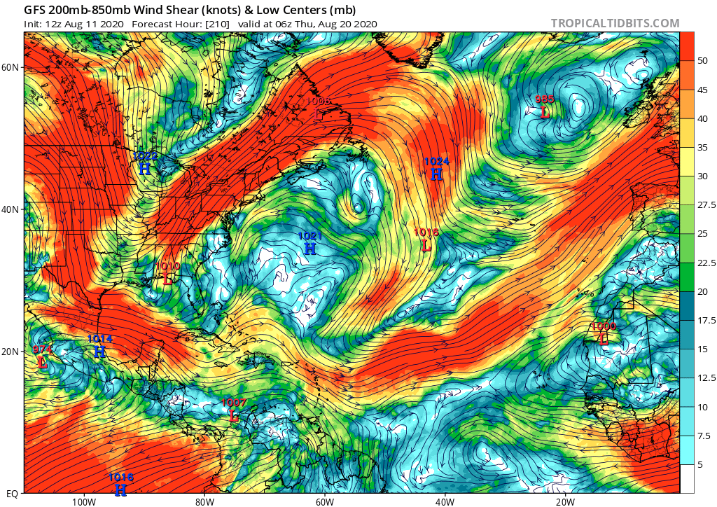
P.S. Things were more interesting before the model upgrades where we could at least talk about some phantoms. Now it seems the models may have the opposite issue
P.S. Things were more interesting before the model upgrades where we could at least talk about some phantoms. Now it seems the models may have the opposite issue
3 likes
-
Ritzcraker
- S2K Supporter
- Posts: 61
- Joined: Sun Oct 07, 2018 2:14 am
Re: 2020 Global Model Runs Discussion (Out thru day 16)
gatorcane wrote:Aug 20th “ring the bell” date looks pretty rough across the Atlantic for tropical development if the GFS is correct:
https://i.postimg.cc/vHxzzTQR/gfs-shear-atl-36.png
P.S. Things were more interesting before the model upgrades where we could at least talk about some phantoms. Now it seems the models may have the opposite issue
Curious why I keep seeing this same shear graphic every 3 days. If we don’t trust GFS for TC genesis past the 5 day mark why on earth do we trust its shear projection? On top of all of that the models have been HORRIBLE with TC genesis this year. 95L was supposed to go “poof” according to the models a few days ago. Now they show it getting farther NW. When will we learn?
11 likes
This post is NOT AN OFFICIAL FORECAST and should not be used as such. It is just the opinion of the poster and may or may not be backed by sound meteorological data. It is NOT endorsed by any professional institution including storm2k.org. For Official Information please refer to the NHC and NWS products.
-
AutoPenalti
- Category 5
- Posts: 4091
- Age: 29
- Joined: Mon Aug 17, 2015 4:16 pm
- Location: Ft. Lauderdale, Florida
Re: 2020 Global Model Runs Discussion (Out thru day 16)
Ritzcraker wrote:gatorcane wrote:Aug 20th “ring the bell” date looks pretty rough across the Atlantic for tropical development if the GFS is correct:
https://i.postimg.cc/vHxzzTQR/gfs-shear-atl-36.png
P.S. Things were more interesting before the model upgrades where we could at least talk about some phantoms. Now it seems the models may have the opposite issue
Curious why I keep seeing this same shear graphic every 3 days. If we don’t trust GFS for TC genesis past the 5 day mark why on earth do we trust its shear projection? On top of all of that the models have been HORRIBLE with TC genesis this year. 95L was supposed to go “poof” according to the models a few days ago. Now they show it getting farther NW. When will we learn?
GFS shear forecast has verified to a certain extent, but still shouldn’t be treated as gospel.
3 likes
The posts in this forum are NOT official forecasts and should not be used as such. They are just the opinion of the poster and may or may not be backed by sound meteorological data. They are NOT endorsed by any professional institution or STORM2K. For official information, please refer to products from the NHC and NWS.
Model Runs Cheat Sheet:
GFS (5:30 AM/PM, 11:30 AM/PM)
HWRF, GFDL, UKMET, NAVGEM (6:30-8:00 AM/PM, 12:30-2:00 AM/PM)
ECMWF (1:45 AM/PM)
TCVN is a weighted averaged
-
Ivanhater

- Storm2k Moderator

- Posts: 11222
- Age: 39
- Joined: Fri Jul 01, 2005 8:25 am
- Location: Pensacola
Re: 2020 Global Model Runs Discussion (Out thru day 16)
Call me crazy but I am still seeing signs of possible activity in the western Caribbean. The GFS starts to move the east pac activity bumping against the coast and the Atlantic waves slowing and "piling up" in the western Caribbean near the end of August
2 likes
Michael
-
gatorcane
- S2K Supporter
- Posts: 23708
- Age: 48
- Joined: Sun Mar 13, 2005 3:54 pm
- Location: Boca Raton, FL
Re: 2020 Global Model Runs Discussion (Out thru day 16)
Ivanhater wrote:Call me crazy but I am still seeing signs of possible activity in the western Caribbean. The GFS starts to move the east pac activity bumping against the coast and the Atlantic waves slowing and "piling up" in the western Caribbean near the end of August
Yes it does seem like little by little the GFS is trying to move the EPAC activity more east. Maybe soon we may see it try to spin up something in the Western Caribbean or BoC.
2 likes
-
ScottNAtlanta

- Category 5
- Posts: 2535
- Joined: Sat May 25, 2013 3:11 pm
- Location: Atlanta, GA
Re: 2020 Global Model Runs Discussion (Out thru day 16)
gatorcane wrote:Ivanhater wrote:Call me crazy but I am still seeing signs of possible activity in the western Caribbean. The GFS starts to move the east pac activity bumping against the coast and the Atlantic waves slowing and "piling up" in the western Caribbean near the end of August
Yes it does seem like little by little the GFS is trying to move the EPAC activity more east. Maybe soon we may see it try to spin up something in the Western Caribbean or BoC.
That would make sense since the MJO is moving that direction on most of the modeling.
0 likes
The posts in this forum are NOT official forecast and should not be used as such. They are just the opinion of the poster and may or may not be backed by sound meteorological data. They are NOT endorsed by any professional institution or storm2k.org. For official information, please refer to the NHC and NWS products.
-
gatorcane
- S2K Supporter
- Posts: 23708
- Age: 48
- Joined: Sun Mar 13, 2005 3:54 pm
- Location: Boca Raton, FL
Re: 2020 Global Model Runs Discussion (Out thru day 16)
ScottNAtlanta wrote:gatorcane wrote:Ivanhater wrote:Call me crazy but I am still seeing signs of possible activity in the western Caribbean. The GFS starts to move the east pac activity bumping against the coast and the Atlantic waves slowing and "piling up" in the western Caribbean near the end of August
Yes it does seem like little by little the GFS is trying to move the EPAC activity more east. Maybe soon we may see it try to spin up something in the Western Caribbean or BoC.
That would make sense since the MJO is moving that direction on most of the modeling.
18Z GFS has something in the long-range there
0 likes
-
Ivanhater
- Storm2k Moderator
- Posts: 11222
- Age: 39
- Joined: Fri Jul 01, 2005 8:25 am
- Location: Pensacola
Re: 2020 Global Model Runs Discussion (Out thru day 16)
Yep, I highly suspect we get something in the NW Caribbean and Gulf at the end of August. I mentioned the other day models were sniffing out a CAG event and the slowing of waves piling up
I'm sure it will drop and come back on models many times but end of August I think we have something there.
Also, next week there may be some mischief in the northern gulf. For a few runs, the gfs has shown a low and deep feed of moisture streaming up along the northern gulf coast

Sent from my SM-G955U using Tapatalk
I'm sure it will drop and come back on models many times but end of August I think we have something there.
Also, next week there may be some mischief in the northern gulf. For a few runs, the gfs has shown a low and deep feed of moisture streaming up along the northern gulf coast
Sent from my SM-G955U using Tapatalk
1 likes
Michael
-
Hurricaneman
- Category 5
- Posts: 7404
- Age: 45
- Joined: Tue Aug 31, 2004 3:24 pm
- Location: central florida
Re: 2020 Global Model Runs Discussion (Out thru day 16)
The GFS is finally picking up on something in the long range, expect some stuff to be picked up in its 10 day maps soon
0 likes
-
TheStormExpert
Re: 2020 Global Model Runs Discussion (Out thru day 16)
gatorcane wrote:Aug 20th “ring the bell” date looks pretty rough across the Atlantic for tropical development if the GFS is correct:
https://i.postimg.cc/vHxzzTQR/gfs-shear-atl-36.png
P.S. Things were more interesting before the model upgrades where we could at least talk about some phantoms. Now it seems the models may have the opposite issue
I'll take the phantom storms at this point. The global models have been pure garbage this year so I wouldn't put too much stock into a shear forecast nine days out. Hopefully conditions improve otherwise the forecasts for a "Extremely Active Season" could be in jeopardy.
0 likes
Who is online
Users browsing this forum: No registered users and 268 guests