2021 Indicators: SST's / SAL / MSLP / Shear / Steering / Instability / Sat Images

This is the general tropical discussion area. Anyone can take their shot at predicting a storms path.

Moderator: S2k Moderators

Forum rules

The posts in this forum are NOT official forecasts and should not be used as such. They are just the opinion of the poster and may or may not be backed by sound meteorological data. They are NOT endorsed by any professional institution or STORM2K. For official information, please refer to products from the National Hurricane Center and National Weather Service.

Help Support Storm2K
Message
Author
User avatar
NotSparta
Professional-Met
Professional-Met
Posts: 1668
Age: 23
Joined: Fri Aug 18, 2017 8:24 am
Location: Naples, FL
Contact:

Re: 2021 Indicators: SST's / SAL / MSLP / Shear / Steering / Instability / Sat Images

#1221 Postby NotSparta » Wed Jul 14, 2021 9:13 am

jconsor wrote:
AlphaToOmega wrote:


That is still a rising cell over the East Pacific even during hyperactive years. 2020 was the only year without -VP anomalies in the East Pacific.


No, the rising cell over the E Pacific is in the active (slightly above normal) year composite. The hyperactive years have a *sinking* cell over the eastern Pacific.


We haven't really had a sinking cell in the East Pacific for a while, ever since the 90s when it used to be a standing wave over the Americas. It's existed in some form pretty much every year except 2010 and 2020
0 likes   
This post was probably an opinion of mine, and in no way is official. Please refer to http://www.hurricanes.gov for official tropical analysis and advisories.

My website, with lots of tropical wx graphics, including satellite and recon: http://cyclonicwx.com

Shell Mound
Category 5
Category 5
Posts: 2434
Age: 32
Joined: Thu Sep 07, 2017 3:39 pm
Location: St. Petersburg, FL → Scandinavia

Re: 2021 Indicators: SST's / SAL / MSLP / Shear / Steering / Instability / Sat Images

#1222 Postby Shell Mound » Wed Jul 14, 2021 9:16 am

So we have a trend toward -ENSO (weak Niña) coupled with the Atlantic Niño + ASW, yet with the MDR remaining coolish come ASO. An interesting combination:

 https://twitter.com/BenNollWeather/status/1415055949903982594


Personally, I think this translates into numerous high-amplitude AEWs exiting at a low latitude and crashing into South America while failing to consolidate.
0 likes   
CVW / MiamiensisWx / Shell Mound
The posts in this forum are NOT official forecasts and should not be used as such. They are just the opinion of the poster and may or may not be backed by sound meteorological data. They are NOT endorsed by any professional institution or STORM2K. For official information, please refer to products from the NHC and NWS.

AlphaToOmega
Category 5
Category 5
Posts: 1448
Joined: Sat Jun 26, 2021 10:51 am
Location: Somewhere in Massachusetts

Re: 2021 Indicators: SST's / SAL / MSLP / Shear / Steering / Instability / Sat Images

#1223 Postby AlphaToOmega » Wed Jul 14, 2021 9:17 am

Shell Mound wrote:So we have a trend toward -ENSO (weak Niña) coupled with the Atlantic Niño + ASW, yet with the MDR remaining coolish come ASO. An interesting combination:

https://twitter.com/BenNollWeather/status/1415055949903982594


The strong ASW should make the MDR significantly above-average come ASO. I think the models have a hard time dealing with the Atlantic Equatorial Mode.
2 likes   

Shell Mound
Category 5
Category 5
Posts: 2434
Age: 32
Joined: Thu Sep 07, 2017 3:39 pm
Location: St. Petersburg, FL → Scandinavia

Re: 2021 Indicators: SST's / SAL / MSLP / Shear / Steering / Instability / Sat Images

#1224 Postby Shell Mound » Wed Jul 14, 2021 9:20 am

AlphaToOmega wrote:
Shell Mound wrote:So we have a trend toward -ENSO (weak Niña) coupled with the Atlantic Niño + ASW, yet with the MDR remaining coolish come ASO. An interesting combination:

https://twitter.com/BenNollWeather/status/1415055949903982594


The strong ASW should make the MDR significantly above-average come ASO. I think the models have a hard time dealing with the Atlantic Equatorial Mode.

The ASW has been strong over the past several months, yet the MDR has barely budged in terms of its SST. As I mentioned previously, the suppressed ITCZ, coupled with the Atlantic Niño, emergent -ENSO, and active African monsoon, will likely lead to large waves exiting West Africa at a low latitude and, owing to their high amplitude and proximity to the equator, fail to develop much vorticity or organisation before crashing into South America or getting torn apart by the accelerating trades over the southeastern Caribbean Sea. Without the +AMM/+AMO stability and associated shear via the TUTT will act to suppress TCG, along with the waves’ being too large to organise before striking the northeastern tip of South America. Currently models strongly concur on the MDR being cool and thus the ITCZ being strongly suppressed come ASO.
0 likes   
CVW / MiamiensisWx / Shell Mound
The posts in this forum are NOT official forecasts and should not be used as such. They are just the opinion of the poster and may or may not be backed by sound meteorological data. They are NOT endorsed by any professional institution or STORM2K. For official information, please refer to products from the NHC and NWS.

User avatar
cycloneye
Admin
Admin
Posts: 145296
Age: 68
Joined: Thu Oct 10, 2002 10:54 am
Location: San Juan, Puerto Rico

Re: 2021 Indicators: SST's / SAL / MSLP / Shear / Steering / Instability / Sat Images

#1225 Postby cycloneye » Wed Jul 14, 2021 9:27 am

Shell Mound So you no longer favor your S2K poll numbers of 17/11/6?

viewtopic.php?f=25&t=121766
0 likes   
Visit the Caribbean-Central America Weather Thread where you can find at first post web cams,radars
and observations from Caribbean basin members Click Here

Shell Mound
Category 5
Category 5
Posts: 2434
Age: 32
Joined: Thu Sep 07, 2017 3:39 pm
Location: St. Petersburg, FL → Scandinavia

Re: 2021 Indicators: SST's / SAL / MSLP / Shear / Steering / Instability / Sat Images

#1226 Postby Shell Mound » Wed Jul 14, 2021 9:28 am

cycloneye wrote:Shell Mound So you no longer favor your S2K poll numbers of 17/11/6?

You are correct, but please do not alter those numbers, as they are “finalised.” I have since altered my expectations since finalisation.
0 likes   
CVW / MiamiensisWx / Shell Mound
The posts in this forum are NOT official forecasts and should not be used as such. They are just the opinion of the poster and may or may not be backed by sound meteorological data. They are NOT endorsed by any professional institution or STORM2K. For official information, please refer to products from the NHC and NWS.

User avatar
cycloneye
Admin
Admin
Posts: 145296
Age: 68
Joined: Thu Oct 10, 2002 10:54 am
Location: San Juan, Puerto Rico

Re: 2021 Indicators: SST's / SAL / MSLP / Shear / Steering / Instability / Sat Images

#1227 Postby cycloneye » Wed Jul 14, 2021 9:30 am

Shell Mound wrote:
cycloneye wrote:Shell Mound So you no longer favor your S2K poll numbers of 17/11/6?

You are correct, but please do not alter those numbers, as they are “finalised.” I have since altered my expectations since finalisation.


I never edit anything after the poll is closed in all the years of polling. That is for the S2K archives.
1 likes   
Visit the Caribbean-Central America Weather Thread where you can find at first post web cams,radars
and observations from Caribbean basin members Click Here

User avatar
ElectricStorm
Category 5
Category 5
Posts: 5044
Age: 24
Joined: Tue Aug 13, 2019 11:23 pm
Location: Skiatook, OK / Norman, OK

Re: 2021 Indicators: SST's / SAL / MSLP / Shear / Steering / Instability / Sat Images

#1228 Postby ElectricStorm » Wed Jul 14, 2021 9:32 am

SSTs will probably warm before peak season like they do pretty much every single year. I personally don't really see much that suggests anything other than a very active season...
5 likes   
B.S Meteorology, University of Oklahoma '25

Please refer to the NHC, NWS, or SPC for official information.

User avatar
NotSparta
Professional-Met
Professional-Met
Posts: 1668
Age: 23
Joined: Fri Aug 18, 2017 8:24 am
Location: Naples, FL
Contact:

Re: 2021 Indicators: SST's / SAL / MSLP / Shear / Steering / Instability / Sat Images

#1229 Postby NotSparta » Wed Jul 14, 2021 9:32 am

Shell Mound wrote:
AlphaToOmega wrote:
Shell Mound wrote:So we have a trend toward -ENSO (weak Niña) coupled with the Atlantic Niño + ASW, yet with the MDR remaining coolish come ASO. An interesting combination:

https://twitter.com/BenNollWeather/status/1415055949903982594


The strong ASW should make the MDR significantly above-average come ASO. I think the models have a hard time dealing with the Atlantic Equatorial Mode.

The ASW has been strong over the past several months, yet the MDR has barely budged in terms of its SST. As I mentioned previously, the suppressed ITCZ, coupled with the Atlantic Niño, emergent -ENSO, and active African monsoon, will likely lead to large waves exiting West Africa at a low latitude and, owing to their high amplitude and proximity to the equator, fail to develop much vorticity or organisation before crashing into South America or getting torn apart by the accelerating trades over the southeastern Caribbean Sea. Without the +AMM/+AMO stability and associated shear via the TUTT will act to suppress TCG, along with the waves’ being too large to organise before striking the northeastern tip of South America. Currently models strongly concur on the MDR being cool and thus the ITCZ being strongly suppressed come ASO.


I would think the Atlantic Niño would help those waves spin up similarly to Elsa. It's one reason these features actually enhance TC activity. Given the current ITCZ activity, unless we see waves quickly gain latitude for some reason stability probably won't be an issue, and I've seen very little signal for a strong TUTT (actually more for a weak one, which also makes sense given it was able to entirely lift out of the Caribbean a few weeks ago) aside from the CFS which has had issues propagating the MJO and typically turns Africa into a mass sink. Low latitude could still be an issue for these waves but I can't see stability or shear being any more of a problem than usual
8 likes   
This post was probably an opinion of mine, and in no way is official. Please refer to http://www.hurricanes.gov for official tropical analysis and advisories.

My website, with lots of tropical wx graphics, including satellite and recon: http://cyclonicwx.com

User avatar
SFLcane
S2K Supporter
S2K Supporter
Posts: 10163
Age: 47
Joined: Sat Jun 05, 2010 1:44 pm
Location: Lake Worth Florida

Re: 2021 Indicators: SST's / SAL / MSLP / Shear / Steering / Instability / Sat Images

#1230 Postby SFLcane » Wed Jul 14, 2021 9:34 am

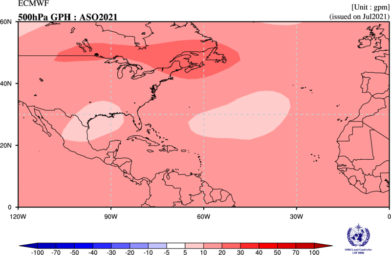
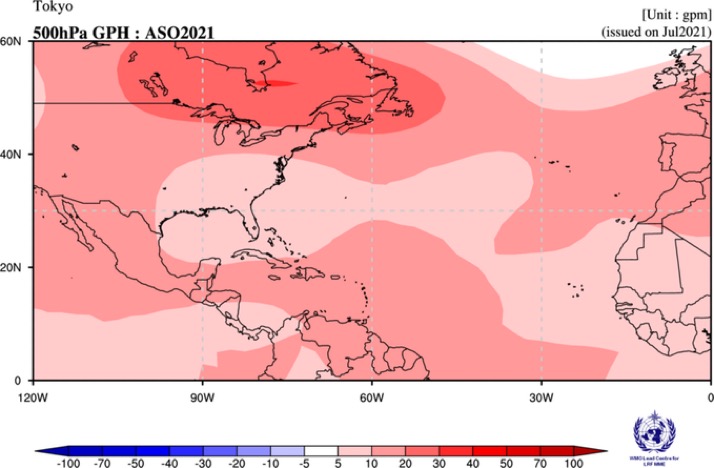
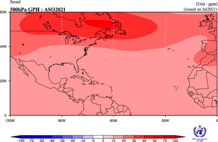
Just to put in perspective why I am so worried about potential impacts to Florida. Taking another look at z500 forecast for this season. Like the Cánsips the JMA (Tokyo) and ECMWF are similar and Korea showing High latitude ridging. Thanks to Yaakov for the site.

Buckle up! No fish food this season

Image

Image

Image
5 likes   

User avatar
NotSparta
Professional-Met
Professional-Met
Posts: 1668
Age: 23
Joined: Fri Aug 18, 2017 8:24 am
Location: Naples, FL
Contact:

Re: 2021 Indicators: SST's / SAL / MSLP / Shear / Steering / Instability / Sat Images

#1231 Postby NotSparta » Wed Jul 14, 2021 9:38 am

Weather Dude wrote:SSTs will probably warm before peak season like they do pretty much every single year. I personally don't really see much that suggests anything other than a very active season...


This is a good point, in the past decade or so and especially since 2015, there have been many -AMMs that have developed in spring or the beginning of summer just for it to recover and get less negative or flip positive by fall, when the values typically maximize as of late. Sort of like the opposite of the 1960s where consistent strong wintertime -NAOs would create strong +AMM events in springtime, for them to usually fade or even flip negative by fall
Last edited by NotSparta on Wed Jul 14, 2021 9:38 am, edited 1 time in total.
1 likes   
This post was probably an opinion of mine, and in no way is official. Please refer to http://www.hurricanes.gov for official tropical analysis and advisories.

My website, with lots of tropical wx graphics, including satellite and recon: http://cyclonicwx.com

Shell Mound
Category 5
Category 5
Posts: 2434
Age: 32
Joined: Thu Sep 07, 2017 3:39 pm
Location: St. Petersburg, FL → Scandinavia

Re: 2021 Indicators: SST's / SAL / MSLP / Shear / Steering / Instability / Sat Images

#1232 Postby Shell Mound » Wed Jul 14, 2021 9:38 am

NotSparta wrote:
Shell Mound wrote:
AlphaToOmega wrote:
The strong ASW should make the MDR significantly above-average come ASO. I think the models have a hard time dealing with the Atlantic Equatorial Mode.

The ASW has been strong over the past several months, yet the MDR has barely budged in terms of its SST. As I mentioned previously, the suppressed ITCZ, coupled with the Atlantic Niño, emergent -ENSO, and active African monsoon, will likely lead to large waves exiting West Africa at a low latitude and, owing to their high amplitude and proximity to the equator, fail to develop much vorticity or organisation before crashing into South America or getting torn apart by the accelerating trades over the southeastern Caribbean Sea. Without the +AMM/+AMO stability and associated shear via the TUTT will act to suppress TCG, along with the waves’ being too large to organise before striking the northeastern tip of South America. Currently models strongly concur on the MDR being cool and thus the ITCZ being strongly suppressed come ASO.
I've seen very little signal for a strong TUTT

The EPS suggests a strongly +NAO during ASO, hence a northward displacement of the STR, implying more of a weakness or TUTT underneath (SFLcane’s images).
1 likes   
CVW / MiamiensisWx / Shell Mound
The posts in this forum are NOT official forecasts and should not be used as such. They are just the opinion of the poster and may or may not be backed by sound meteorological data. They are NOT endorsed by any professional institution or STORM2K. For official information, please refer to products from the NHC and NWS.

User avatar
SFLcane
S2K Supporter
S2K Supporter
Posts: 10163
Age: 47
Joined: Sat Jun 05, 2010 1:44 pm
Location: Lake Worth Florida

Re: 2021 Indicators: SST's / SAL / MSLP / Shear / Steering / Instability / Sat Images

#1233 Postby SFLcane » Wed Jul 14, 2021 9:41 am

0 likes   

User avatar
SFLcane
S2K Supporter
S2K Supporter
Posts: 10163
Age: 47
Joined: Sat Jun 05, 2010 1:44 pm
Location: Lake Worth Florida

Re: 2021 Indicators: SST's / SAL / MSLP / Shear / Steering / Instability / Sat Images

#1234 Postby SFLcane » Wed Jul 14, 2021 9:41 am

Shell Mound wrote:
NotSparta wrote:
Shell Mound wrote:The ASW has been strong over the past several months, yet the MDR has barely budged in terms of its SST. As I mentioned previously, the suppressed ITCZ, coupled with the Atlantic Niño, emergent -ENSO, and active African monsoon, will likely lead to large waves exiting West Africa at a low latitude and, owing to their high amplitude and proximity to the equator, fail to develop much vorticity or organisation before crashing into South America or getting torn apart by the accelerating trades over the southeastern Caribbean Sea. Without the +AMM/+AMO stability and associated shear via the TUTT will act to suppress TCG, along with the waves’ being too large to organise before striking the northeastern tip of South America. Currently models strongly concur on the MDR being cool and thus the ITCZ being strongly suppressed come ASO.
I've seen very little signal for a strong TUTT

The EPS suggests a strongly +NAO during ASO, hence a northward displacement of the STR, implying more of a weakness or TUTT underneath (SFLcane’s images).


Please give this up. :roll:
6 likes   

User avatar
cycloneye
Admin
Admin
Posts: 145296
Age: 68
Joined: Thu Oct 10, 2002 10:54 am
Location: San Juan, Puerto Rico

Re: 2021 Indicators: SST's / SAL / MSLP / Shear / Steering / Instability / Sat Images

#1235 Postby cycloneye » Wed Jul 14, 2021 9:43 am


Those words long-lived. Yikes.
0 likes   
Visit the Caribbean-Central America Weather Thread where you can find at first post web cams,radars
and observations from Caribbean basin members Click Here

Shell Mound
Category 5
Category 5
Posts: 2434
Age: 32
Joined: Thu Sep 07, 2017 3:39 pm
Location: St. Petersburg, FL → Scandinavia

Re: 2021 Indicators: SST's / SAL / MSLP / Shear / Steering / Instability / Sat Images

#1236 Postby Shell Mound » Wed Jul 14, 2021 9:44 am

Last edited by Shell Mound on Wed Jul 14, 2021 9:53 am, edited 1 time in total.
0 likes   
CVW / MiamiensisWx / Shell Mound
The posts in this forum are NOT official forecasts and should not be used as such. They are just the opinion of the poster and may or may not be backed by sound meteorological data. They are NOT endorsed by any professional institution or STORM2K. For official information, please refer to products from the NHC and NWS.

User avatar
NotSparta
Professional-Met
Professional-Met
Posts: 1668
Age: 23
Joined: Fri Aug 18, 2017 8:24 am
Location: Naples, FL
Contact:

Re: 2021 Indicators: SST's / SAL / MSLP / Shear / Steering / Instability / Sat Images

#1237 Postby NotSparta » Wed Jul 14, 2021 9:46 am

Shell Mound wrote:
NotSparta wrote:
Shell Mound wrote:The ASW has been strong over the past several months, yet the MDR has barely budged in terms of its SST. As I mentioned previously, the suppressed ITCZ, coupled with the Atlantic Niño, emergent -ENSO, and active African monsoon, will likely lead to large waves exiting West Africa at a low latitude and, owing to their high amplitude and proximity to the equator, fail to develop much vorticity or organisation before crashing into South America or getting torn apart by the accelerating trades over the southeastern Caribbean Sea. Without the +AMM/+AMO stability and associated shear via the TUTT will act to suppress TCG, along with the waves’ being too large to organise before striking the northeastern tip of South America. Currently models strongly concur on the MDR being cool and thus the ITCZ being strongly suppressed come ASO.
I've seen very little signal for a strong TUTT

The EPS suggests a strongly +NAO during ASO, hence a northward displacement of the STR, implying more of a weakness or TUTT underneath (SFLcane’s images).


Oh yeah I could certainly see that. Just haven't seen a lot of shear forecasts lately that look like a classic TUTT. The most recent IMME run actually had a lot of westerly shear in the MDR but the TUTT was nowhere to be seen, it seemed to be caused by an overactive ITCZ
1 likes   
This post was probably an opinion of mine, and in no way is official. Please refer to http://www.hurricanes.gov for official tropical analysis and advisories.

My website, with lots of tropical wx graphics, including satellite and recon: http://cyclonicwx.com

Shell Mound
Category 5
Category 5
Posts: 2434
Age: 32
Joined: Thu Sep 07, 2017 3:39 pm
Location: St. Petersburg, FL → Scandinavia

Re: 2021 Indicators: SST's / SAL / MSLP / Shear / Steering / Instability / Sat Images

#1238 Postby Shell Mound » Wed Jul 14, 2021 9:48 am

NotSparta wrote:
Shell Mound wrote:
NotSparta wrote:I've seen very little signal for a strong TUTT

The EPS suggests a strongly +NAO during ASO, hence a northward displacement of the STR, implying more of a weakness or TUTT underneath (SFLcane’s images).


Oh yeah I could certainly see that. Just haven't seen a lot of shear forecasts lately that look like a classic TUTT. The most recent IMME run actually had a lot of westerly shear in the MDR but the TUTT was nowhere to be seen, it seemed to be caused by an overactive ITCZ

If the NAO is strongly positive during the same timeframe, then the coolish MDR + any EPAC convection + TUTT + ITCZ-related VWS could really kill the CV season.

Additionally, such a strongly +NAO, by imparting a TUTT-related weakness beneath the displaced STR, could allow storms that develop to head OTS earlier.
0 likes   
CVW / MiamiensisWx / Shell Mound
The posts in this forum are NOT official forecasts and should not be used as such. They are just the opinion of the poster and may or may not be backed by sound meteorological data. They are NOT endorsed by any professional institution or STORM2K. For official information, please refer to products from the NHC and NWS.

User avatar
NotSparta
Professional-Met
Professional-Met
Posts: 1668
Age: 23
Joined: Fri Aug 18, 2017 8:24 am
Location: Naples, FL
Contact:

Re: 2021 Indicators: SST's / SAL / MSLP / Shear / Steering / Instability / Sat Images

#1239 Postby NotSparta » Wed Jul 14, 2021 9:51 am

Shell Mound wrote:
NotSparta wrote:
Shell Mound wrote:The EPS suggests a strongly +NAO during ASO, hence a northward displacement of the STR, implying more of a weakness or TUTT underneath (SFLcane’s images).


Oh yeah I could certainly see that. Just haven't seen a lot of shear forecasts lately that look like a classic TUTT. The most recent IMME run actually had a lot of westerly shear in the MDR but the TUTT was nowhere to be seen, it seemed to be caused by an overactive ITCZ

If the NAO is strongly positive during the same timeframe, then the coolish MDR + any EPAC convection + TUTT + ITCZ-related VWS could really kill the CV season.


EPAC convection looks suppressed, and you can't have the TUTT and an active ITCZ shearing the tropics at the same time. If the ITCZ is that strong, all the upper level heat release and -VP generation will severely stunt the TUTT
6 likes   
This post was probably an opinion of mine, and in no way is official. Please refer to http://www.hurricanes.gov for official tropical analysis and advisories.

My website, with lots of tropical wx graphics, including satellite and recon: http://cyclonicwx.com

Shell Mound
Category 5
Category 5
Posts: 2434
Age: 32
Joined: Thu Sep 07, 2017 3:39 pm
Location: St. Petersburg, FL → Scandinavia

Re: 2021 Indicators: SST's / SAL / MSLP / Shear / Steering / Instability / Sat Images

#1240 Postby Shell Mound » Wed Jul 14, 2021 9:55 am

NotSparta wrote:
Shell Mound wrote:
NotSparta wrote:
Oh yeah I could certainly see that. Just haven't seen a lot of shear forecasts lately that look like a classic TUTT. The most recent IMME run actually had a lot of westerly shear in the MDR but the TUTT was nowhere to be seen, it seemed to be caused by an overactive ITCZ

If the NAO is strongly positive during the same timeframe, then the coolish MDR + any EPAC convection + TUTT + ITCZ-related VWS could really kill the CV season.


EPAC convection looks suppressed, and you can't have the TUTT and an active ITCZ shearing the tropics at the same time. If the ITCZ is that strong, all the upper level heat release and -VP generation will severely stunt the TUTT

Do you think the active ITCZ could partly offset the coolish MDR (implied stability) and thus still produce some large storms, à la Frances, Ivan, or Irma?

 https://twitter.com/DerekOrtt/status/1415076770743832581


0 likes   
CVW / MiamiensisWx / Shell Mound
The posts in this forum are NOT official forecasts and should not be used as such. They are just the opinion of the poster and may or may not be backed by sound meteorological data. They are NOT endorsed by any professional institution or STORM2K. For official information, please refer to products from the NHC and NWS.


Return to “Talkin' Tropics”

Who is online

Users browsing this forum: Kingarabian and 41 guests