ENSO Updates (2007 thru 2023)

This is the general tropical discussion area. Anyone can take their shot at predicting a storms path.

Moderator: S2k Moderators

Forum rules

The posts in this forum are NOT official forecasts and should not be used as such. They are just the opinion of the poster and may or may not be backed by sound meteorological data. They are NOT endorsed by any professional institution or STORM2K. For official information, please refer to products from the National Hurricane Center and National Weather Service.

Help Support Storm2K
Message
Author
User avatar
Kingarabian
S2K Supporter
S2K Supporter
Posts: 15461
Joined: Sat Aug 08, 2009 3:06 am
Location: Honolulu, Hawaii

Re: ENSO Updates

#12381 Postby Kingarabian » Sun Mar 27, 2022 2:35 pm

DorkyMcDorkface wrote:
Kingarabian wrote:
DorkyMcDorkface wrote:Definitely not 2017, although you could argue it was somewhat of a negative factor in 2012 since that was a warm-neutral year. MDR activity was generally weak as a result despite the high NS count.

2017 was the prime example of a surface El Nino.

http://i.imgur.com/m1QsrRK.gif
http://i.imgur.com/e7KpZGC.gif

Yeah I meant to say it didn't limit 2017, my bad, it does appear as if I was saying 2017 didn't have a coastal Niño at one point. It definitely did as you said:
https://i.ibb.co/XbcSLfc/oisst-anom-1d-globe-2017031700.png

Oops I edited my post to late lol.
0 likes   
RIP Kobe Bryant

User avatar
Yellow Evan
Professional-Met
Professional-Met
Posts: 15960
Age: 25
Joined: Fri Jul 15, 2011 12:48 pm
Location: Henderson, Nevada/Honolulu, HI
Contact:

Re: ENSO Updates

#12382 Postby Yellow Evan » Sun Mar 27, 2022 3:27 pm

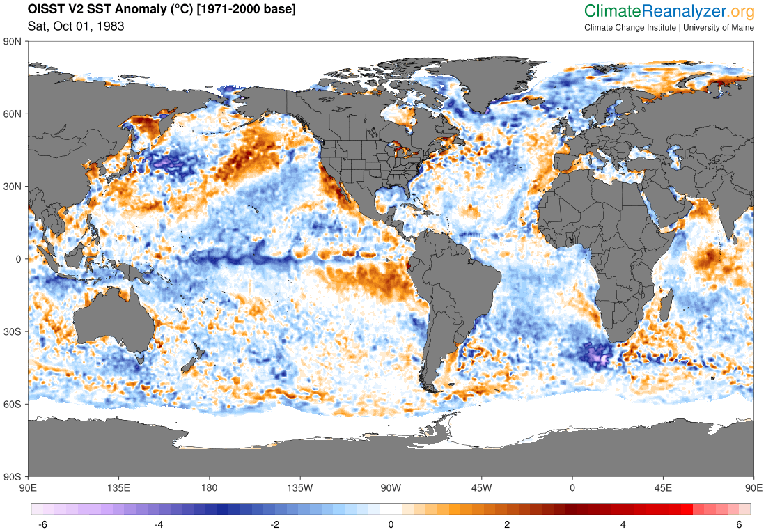
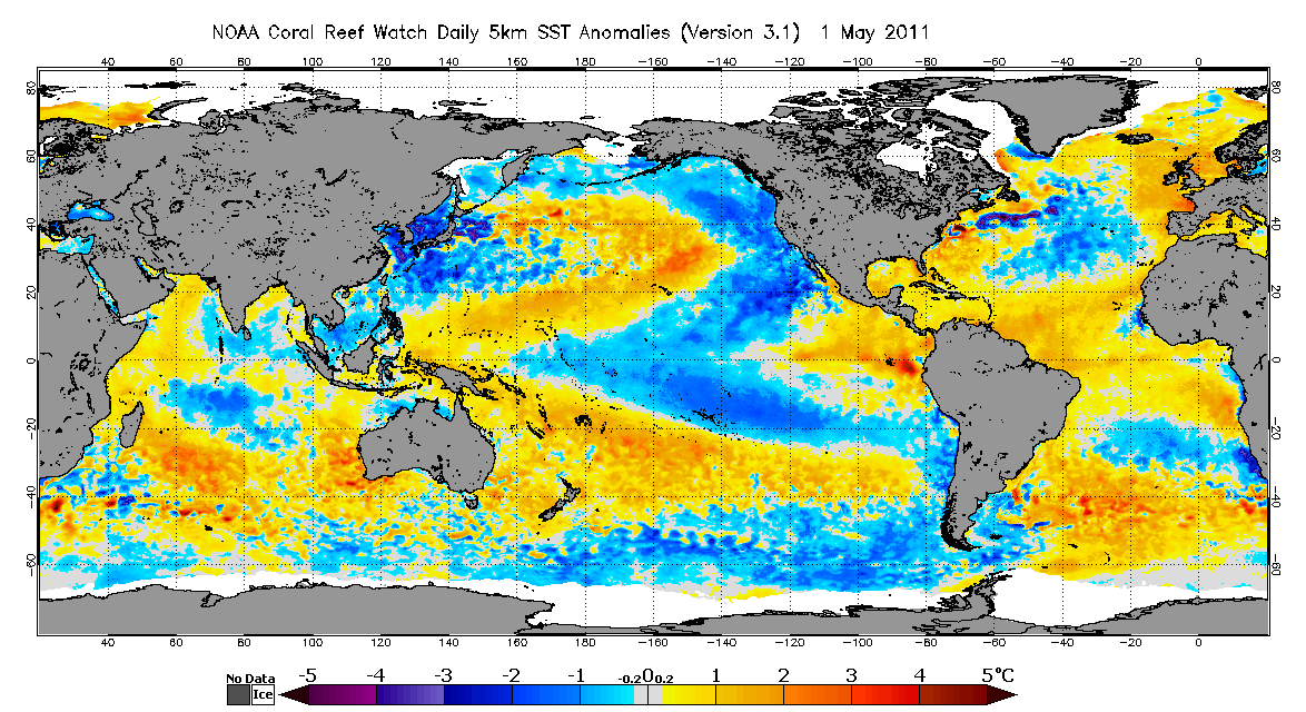
It’s plausible that a costal Nino might have an affect on TC activity in some instances via higher shear in the Carriben due to rising motion over 1+2. Below are years where the EPAC overpreformed and the ATL underperformed relative to the AMO and 3.4 ENSO region and had warm waters off South America.

Image

Image

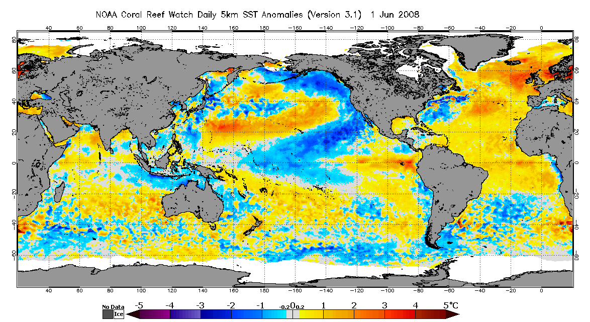
Yet you also have years like 2008 which preformed as you’d expect out of a 2nd year Nina.

Image

In the short term most important effects will probably be local ie less nutrient waters offshore Peru and Ecuador due to less upwelling which hurts the fishing industry.
5 likes   

User avatar
Kingarabian
S2K Supporter
S2K Supporter
Posts: 15461
Joined: Sat Aug 08, 2009 3:06 am
Location: Honolulu, Hawaii

Re: ENSO Updates

#12383 Postby Kingarabian » Mon Mar 28, 2022 11:32 am

-5C and -6C on the latest subsurface update. Buoys still don't show anything more than -2C but that's likely due to a sensor issue. Once some of these anomalies expand further east, the buoys should adjust.
3 likes   
RIP Kobe Bryant

User avatar
cycloneye
Admin
Admin
Posts: 139596
Age: 67
Joined: Thu Oct 10, 2002 10:54 am
Location: San Juan, Puerto Rico

Re: ENSO Updates

#12384 Postby cycloneye » Tue Mar 29, 2022 6:09 pm

0 likes   
Visit the Caribbean-Central America Weather Thread where you can find at first post web cams,radars
and observations from Caribbean basin members Click Here

User avatar
DorkyMcDorkface
Category 2
Category 2
Posts: 743
Age: 26
Joined: Mon Sep 30, 2019 1:32 pm
Location: Mid-Atlantic

Re: ENSO Updates

#12385 Postby DorkyMcDorkface » Tue Mar 29, 2022 6:36 pm


That's just the remnant warm pool surfacing which resembles a "coastal Niño" somewhat. Overall subsurface is very much in Niña mode, just CP-based for now. If +NPMM persists don't be surprised to see if shift back east however, especially if subsequent trade bursts produce another upwelling KW.
Image
Image
7 likes   
Floyd 1999 | Isabel 2003 | Hanna 2008 | Irene 2011 | Sandy 2012 | Isaias 2020

User avatar
Kingarabian
S2K Supporter
S2K Supporter
Posts: 15461
Joined: Sat Aug 08, 2009 3:06 am
Location: Honolulu, Hawaii

Re: ENSO Updates

#12386 Postby Kingarabian » Thu Mar 31, 2022 1:36 pm

GFS showing a strong WWB(10-12Ms) near 150E but that's because its modeling a much stronger CCKW compared to the Euro and CFS.
0 likes   
RIP Kobe Bryant

User avatar
Category5Kaiju
Category 5
Category 5
Posts: 3438
Age: 22
Joined: Thu Dec 24, 2020 12:45 pm
Location: Seattle

Re: ENSO Updates

#12387 Postby Category5Kaiju » Fri Apr 01, 2022 7:44 am

It looks like wxman57 has an interesting take on this situation, that a warm neutral or El Nino could possibly happen and that the models are underestimating the Pacific anomalies.
0 likes   
Unless explicitly stated, all information covered in my posts is based on my opinions and observations. Please refer to a professional meteorologist or an accredited weather research agency otherwise, especially if serious decisions must be made in the event of a potentially life-threatening tropical storm or hurricane.

User avatar
Yellow Evan
Professional-Met
Professional-Met
Posts: 15960
Age: 25
Joined: Fri Jul 15, 2011 12:48 pm
Location: Henderson, Nevada/Honolulu, HI
Contact:

Re: ENSO Updates

#12388 Postby Yellow Evan » Fri Apr 01, 2022 8:59 am

Category5Kaiju wrote:It looks like wxman57 has an interesting take on this situation, that a warm neutral or El Nino could possibly happen and that the models are underestimating the Pacific anomalies.


I’ve yet to see that happen even once in my 12 years following ENSO. Don’t see a reason for that to happen here when the main westerly anomalies are not even going to be particularly centered in the 3.4 region.
1 likes   

User avatar
cycloneye
Admin
Admin
Posts: 139596
Age: 67
Joined: Thu Oct 10, 2002 10:54 am
Location: San Juan, Puerto Rico

Re: ENSO Updates

#12389 Postby cycloneye » Fri Apr 01, 2022 10:29 am

Category5Kaiju wrote:It looks like wxman57 has an interesting take on this situation, that a warm neutral or El Nino could possibly happen and that the models are underestimating the Pacific anomalies.


That was a great joke of April fools day. :D
5 likes   
Visit the Caribbean-Central America Weather Thread where you can find at first post web cams,radars
and observations from Caribbean basin members Click Here

User avatar
Category5Kaiju
Category 5
Category 5
Posts: 3438
Age: 22
Joined: Thu Dec 24, 2020 12:45 pm
Location: Seattle

Re: ENSO Updates

#12390 Postby Category5Kaiju » Fri Apr 01, 2022 11:20 am

cycloneye wrote:
Category5Kaiju wrote:It looks like wxman57 has an interesting take on this situation, that a warm neutral or El Nino could possibly happen and that the models are underestimating the Pacific anomalies.


That was a great joke of April fools day. :D


Yeah, gotta admit, that was well-executed. It seemed so legitimate, particularly coming from wxman57 lol
3 likes   
Unless explicitly stated, all information covered in my posts is based on my opinions and observations. Please refer to a professional meteorologist or an accredited weather research agency otherwise, especially if serious decisions must be made in the event of a potentially life-threatening tropical storm or hurricane.

User avatar
Kingarabian
S2K Supporter
S2K Supporter
Posts: 15461
Joined: Sat Aug 08, 2009 3:06 am
Location: Honolulu, Hawaii

Re: ENSO Updates

#12391 Postby Kingarabian » Fri Apr 01, 2022 3:20 pm

Models backing off on a strong WWB over the EPAC that would've bolstered a coastal Nino heading into the summer.
1 likes   
RIP Kobe Bryant

User avatar
Kingarabian
S2K Supporter
S2K Supporter
Posts: 15461
Joined: Sat Aug 08, 2009 3:06 am
Location: Honolulu, Hawaii

Re: ENSO Updates

#12392 Postby Kingarabian » Mon Apr 04, 2022 1:54 pm

CPC update has Nino 1+2 at -1.0C today. Similar to OISST. CDAS and CRW seem to be over doing the warming at Nino 1+2.
0 likes   
RIP Kobe Bryant

User avatar
cycloneye
Admin
Admin
Posts: 139596
Age: 67
Joined: Thu Oct 10, 2002 10:54 am
Location: San Juan, Puerto Rico

Re: ENSO Updates

#12393 Postby cycloneye » Mon Apr 04, 2022 5:27 pm

0 likes   
Visit the Caribbean-Central America Weather Thread where you can find at first post web cams,radars
and observations from Caribbean basin members Click Here

User avatar
cycloneye
Admin
Admin
Posts: 139596
Age: 67
Joined: Thu Oct 10, 2002 10:54 am
Location: San Juan, Puerto Rico

Re: ENSO Updates

#12394 Postby cycloneye » Tue Apr 05, 2022 7:48 am

0 likes   
Visit the Caribbean-Central America Weather Thread where you can find at first post web cams,radars
and observations from Caribbean basin members Click Here

User avatar
Category5Kaiju
Category 5
Category 5
Posts: 3438
Age: 22
Joined: Thu Dec 24, 2020 12:45 pm
Location: Seattle

Re: ENSO Updates

#12395 Postby Category5Kaiju » Tue Apr 05, 2022 8:03 am


Looks like the MDR may warm up in April with that forecasted wall of westerlies?
0 likes   
Unless explicitly stated, all information covered in my posts is based on my opinions and observations. Please refer to a professional meteorologist or an accredited weather research agency otherwise, especially if serious decisions must be made in the event of a potentially life-threatening tropical storm or hurricane.

User avatar
Yellow Evan
Professional-Met
Professional-Met
Posts: 15960
Age: 25
Joined: Fri Jul 15, 2011 12:48 pm
Location: Henderson, Nevada/Honolulu, HI
Contact:

Re: ENSO Updates

#12396 Postby Yellow Evan » Tue Apr 05, 2022 10:54 am

Category5Kaiju wrote:


Looks like the MDR may warm up in April with that forecasted wall of westerlies?


Too far south.
4 likes   

User avatar
DorkyMcDorkface
Category 2
Category 2
Posts: 743
Age: 26
Joined: Mon Sep 30, 2019 1:32 pm
Location: Mid-Atlantic

Re: ENSO Updates

#12397 Postby DorkyMcDorkface » Tue Apr 05, 2022 11:58 am

Category5Kaiju wrote:


Looks like the MDR may warm up in April with that forecasted wall of westerlies?

This is for the equatorial regions.
0 likes   
Floyd 1999 | Isabel 2003 | Hanna 2008 | Irene 2011 | Sandy 2012 | Isaias 2020

User avatar
cycloneye
Admin
Admin
Posts: 139596
Age: 67
Joined: Thu Oct 10, 2002 10:54 am
Location: San Juan, Puerto Rico

Re: ENSO Updates

#12398 Postby cycloneye » Fri Apr 08, 2022 9:08 am

0 likes   
Visit the Caribbean-Central America Weather Thread where you can find at first post web cams,radars
and observations from Caribbean basin members Click Here

User avatar
Kingarabian
S2K Supporter
S2K Supporter
Posts: 15461
Joined: Sat Aug 08, 2009 3:06 am
Location: Honolulu, Hawaii

Re: ENSO Updates

#12399 Postby Kingarabian » Fri Apr 08, 2022 2:04 pm

:uarrow:

That WPAC WWB is way too west for any meaningful ENSO implications regardless of TC activity. Last year we had a stronger WWB event near 140E-150E and it was still too far west.
4 likes   
RIP Kobe Bryant

User avatar
cycloneye
Admin
Admin
Posts: 139596
Age: 67
Joined: Thu Oct 10, 2002 10:54 am
Location: San Juan, Puerto Rico

Re: ENSO: Breaking News: CPC April update=La Niña-51% - Neutral-45% - El Niño 7% for ASO

#12400 Postby cycloneye » Thu Apr 14, 2022 9:13 am

The April CPC update increases La Niña for ASO up to 51% and that is up from 45% on the March update. It has Neutral at 45% and that is the same and decrease4 el niño to 7%.

EL NIÑO/SOUTHERN OSCILLATION (ENSO)
DIAGNOSTIC DISCUSSION
issued by
CLIMATE PREDICTION CENTER/NCEP/NWS
and the International Research Institute for Climate and Society
14 April 2022

ENSO Alert System Status: La Niña Advisory


Synopsis: La Niña is favored to continue through the Northern Hemisphere summer (59% chance during June-August 2022), with a 50-55% chance through the fall.

During March 2022, La Niña continued with below-average sea surface temperatures (SSTs) across the central and eastern equatorial Pacific Ocean [Fig. 1]. In the past week, all of the Niño index regions were between -0.7°C and -1.1°C [Fig. 2]. Subsurface temperatures anomalies (averaged between 180°-100°W and 0-300m depth) decreased and were negative the entire month [Fig. 3] due to the expansion of below-average temperatures from the surface to 200 meters depth in the east-central equatorial Pacific Ocean [Fig. 4]. For the monthly average, low-level easterly wind anomalies prevailed across the western and central Pacific, and upper-level westerly wind anomalies remained over the east-central Pacific. Suppressed convection remained significant around the Date Line and was enhanced over the Philippines and Southeast Asia [Fig. 5]. Overall, the coupled ocean-atmosphere system reflected the continuation of La Niña.

The most recent IRI/CPC plume average for the Niño-3.4 SST index forecasts a transition to ENSO-neutral during the Northern Hemisphere summer [Fig. 6]. This month, the forecaster consensus predicts Niño-3.4 index values to weaken into the summer but remain below the threshold of La Niña (Niño-3.4 values equal to or less than -0.5°C). The change in the consensus forecast to slightly favoring the continuation of La Nina is primarily based on recent model runs from the North American Multi-Model Ensemble (NMME) and the persistence of atmosphere-ocean coupling, which remains fairly strong for this time of year. While La Niña is slightly favored through the fall, there is still a considerable amount of uncertainty, given the combined 45-50% chance for ENSO-neutral or El Niño from July-September onwards. In summary, La Niña is favored to continue through the Northern Hemisphere summer (59% chance during June-August 2022), with a 50-55% chance through the fall; click CPC/IRI consensus forecast for the chances in each 3-month period).


https://www.cpc.ncep.noaa.gov/products/ ... disc.shtml

Image
4 likes   
Visit the Caribbean-Central America Weather Thread where you can find at first post web cams,radars
and observations from Caribbean basin members Click Here


Return to “Talkin' Tropics”

Who is online

Users browsing this forum: BigB0882, cainjamin, cheezyWXguy, Cpv17, duilaslol, Google [Bot], idaknowman, jgh, MetroMike, ScottNAtlanta, skyline385, TheAustinMan, Wampadawg and 86 guests