2020 Global Model Runs Discussion (Out thru day 16)
Moderator: S2k Moderators
Forum rules

The posts in this forum are NOT official forecasts and should not be used as such. They are just the opinion of the poster and may or may not be backed by sound meteorological data. They are NOT endorsed by any professional institution or STORM2K. For official information, please refer to products from the National Hurricane Center and National Weather Service.
-
StruThiO

- Category 3

- Posts: 821
- Age: 26
- Joined: Fri Sep 15, 2017 5:51 am
- Location: Currently Portland, OR. Raised in Jax, FL.
Re: 2020 Global Model Runs Discussion (Out thru day 16)
Anyone basing a prediction on the lid coming off later than August 20-25 on the GFS should stop making predictions and find a hobby better suited for them, like perhaps coloring.
4 likes
-
TheProfessor

- Professional-Met

- Posts: 3506
- Age: 29
- Joined: Tue Dec 03, 2013 10:56 am
- Location: Wichita, Kansas
Re: 2020 Global Model Runs Discussion (Out thru day 16)
All I have to say is that if anything gets trapped underneath that ridge that the GFS, Euro, and CMC are showing 7-10 days from now then lookout.  With the way the ridge is oriented and the weakness over the central Gulf states, that's a very bad steering flow towards the U.S mainland.
6 likes
An alumnus of The Ohio State University.
Your local National Weather Service office is your best source for weather information.
Your local National Weather Service office is your best source for weather information.
-
SFLcane

- S2K Supporter

- Posts: 10281
- Age: 48
- Joined: Sat Jun 05, 2010 1:44 pm
- Location: Lake Worth Florida
Re: 2020 Global Model Runs Discussion (Out thru day 16)
TheProfessor wrote:All I have to say is that if anything gets trapped underneath that ridge that the GFS, Euro, and CMC are showing 7-10 days from now then lookout.
Yes, I mentioned this a few days ago one trof doesn’t make a pattern. It’s been a very worrisome steering for a few weeks now could mean big problems in the heart of the season.
1 likes

Re: 2020 Global Model Runs Discussion (Out thru day 16)
12z GFS is still as quiet as a mouse. It won’t show a TC unless it’s force-fed one. However, the last several runs have shown a strong AEW going into the Caribbean next week, which could be something to watch.
0 likes
Irene '11 Sandy '12 Hermine '16 5/15/2018 Derecho Fay '20 Isaias '20 Elsa '21 Henri '21 Ida '21
I am only a meteorology enthusiast who knows a decent amount about tropical cyclones. Look to the professional mets, the NHC, or your local weather office for the best information.
I am only a meteorology enthusiast who knows a decent amount about tropical cyclones. Look to the professional mets, the NHC, or your local weather office for the best information.
-
Ivanhater

- Storm2k Moderator

- Posts: 11222
- Age: 39
- Joined: Fri Jul 01, 2005 8:25 am
- Location: Pensacola
Re: 2020 Global Model Runs Discussion (Out thru day 16)
12z Gfs has a 1001mb low in the NW Caribbean. I still think it is out to lunch hanging too much activity in the epac but it is trying.
As I've said, the NW Caribbean is the area to watch the last week of August
Sent from my SM-G955U using Tapatalk
As I've said, the NW Caribbean is the area to watch the last week of August
Sent from my SM-G955U using Tapatalk
2 likes
Michael
-
AutoPenalti
- Category 5

- Posts: 4091
- Age: 29
- Joined: Mon Aug 17, 2015 4:16 pm
- Location: Ft. Lauderdale, Florida
Re: 2020 Global Model Runs Discussion (Out thru day 16)
gatorcane wrote:Hurricaneman wrote:The GFS is saying there’s an El Niño out there with its output, as they say garbage in garbage out, the Euro ensembles are showing an uptick between the 20th and 25th so the Euro seems to have the correct pattern With a more La Niña like one as opposed to the new joke called the GFS
I would say the model accurately predicted the uptick in EPAC activity well in advance in the long-range and so far has been forecasting the shear reasonably well out through the mid to long range across the Atlantic MDR. It was a little off with Josephine but let’s face it the storm is weak and sheared anyway so nothing to be concerned with.
I think the GFS has really struggled with some of its genesis forecasts. That being said, it’s still resolving its intensities.
0 likes
The posts in this forum are NOT official forecasts and should not be used as such. They are just the opinion of the poster and may or may not be backed by sound meteorological data. They are NOT endorsed by any professional institution or STORM2K. For official information, please refer to products from the NHC and NWS.
Model Runs Cheat Sheet:
GFS (5:30 AM/PM, 11:30 AM/PM)
HWRF, GFDL, UKMET, NAVGEM (6:30-8:00 AM/PM, 12:30-2:00 AM/PM)
ECMWF (1:45 AM/PM)
TCVN is a weighted averaged
-
CyclonicFury

- Category 5
- Posts: 2038
- Age: 27
- Joined: Sun Jul 02, 2017 12:32 pm
- Location: NC
- Contact:
Re: 2020 Global Model Runs Discussion (Out thru day 16)
AutoPenalti wrote:gatorcane wrote:Hurricaneman wrote:The GFS is saying there’s an El Niño out there with its output, as they say garbage in garbage out, the Euro ensembles are showing an uptick between the 20th and 25th so the Euro seems to have the correct pattern With a more La Niña like one as opposed to the new joke called the GFS
I would say the model accurately predicted the uptick in EPAC activity well in advance in the long-range and so far has been forecasting the shear reasonably well out through the mid to long range across the Atlantic MDR. It was a little off with Josephine but let’s face it the storm is weak and sheared anyway so nothing to be concerned with.
I think the GFS has really struggled with some of its genesis forecasts. That being said, it’s still resolving its intensities.
In recent years, GFS has seemingly been unable to detect long-range MDR development. It never picked up on the wave that spawned Isaias until it exited Africa. It almost never develops strong MDR ghost storms anymore. Instead, it'll spin up bogus CAG-like hurricanes in the NW Caribbean and GoM at times of year when climatology does not favor them.
5 likes
NCSU B.S. in Meteorology Class of 2021. Tropical weather blogger at http://www.cyclonicfury.com. My forecasts and thoughts are NOT official, for official forecasts please consult the National Hurricane Center.
-
gatorcane

- S2K Supporter
- Posts: 23708
- Age: 48
- Joined: Sun Mar 13, 2005 3:54 pm
- Location: Boca Raton, FL
Re: 2020 Global Model Runs Discussion (Out thru day 16)
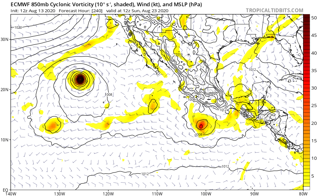
The ECMWF is keeping development over in the EPAC for the next 10 days, how the 12Z run ends:
1 likes
-
SFLcane
- S2K Supporter
- Posts: 10281
- Age: 48
- Joined: Sat Jun 05, 2010 1:44 pm
- Location: Lake Worth Florida
Re: 2020 Global Model Runs Discussion (Out thru day 16)
gatorcane wrote:The ECMWF is keeping development over in the EPAC for the next 10 days, how the 12Z run ends:
https://i.postimg.cc/Kv1xrzVC/ecmwf-uv850-vort-epac-11.png
Why wouldn’t it the MJO is right over the eastern pacific. Development is not expected across the Atl basin till months end.
1 likes
-
EquusStorm
- Category 5
- Posts: 1649
- Age: 35
- Joined: Thu Nov 07, 2013 1:04 pm
- Location: Jasper, AL
- Contact:
Re: 2020 Global Model Runs Discussion (Out thru day 16)
A 'little' off with Josephine, off with Isaias until it actually formed, very off with Hanna, completely off with Gonzalo... yeah not an ideal track record with AEW development at all I'd say
Little better with EPac systems, but again, they've all turned out to be nothingburgers except maybe the big boi coming next week. Maybe that one will challenge Douglas but IF it winds up as brief and weak as all the others I think it's time to assume it's overdoing the EPac development in a year where the base state is just not that favorable there
Little better with EPac systems, but again, they've all turned out to be nothingburgers except maybe the big boi coming next week. Maybe that one will challenge Douglas but IF it winds up as brief and weak as all the others I think it's time to assume it's overdoing the EPac development in a year where the base state is just not that favorable there
Last edited by EquusStorm on Thu Aug 13, 2020 2:20 pm, edited 1 time in total.
1 likes
Colors of lost purpose on the canvas of irrelevance
Not a meteorologist, in fact more of an idiot than anything. You should probably check with the NHC or a local NWS office for official information.
Not a meteorologist, in fact more of an idiot than anything. You should probably check with the NHC or a local NWS office for official information.
Re: 2020 Global Model Runs Discussion (Out thru day 16)
gatorcane wrote:The ECMWF is keeping development over in the EPAC for the next 10 days, how the 12Z run ends:
https://i.postimg.cc/Kv1xrzVC/ecmwf-uv850-vort-epac-11.png
It’s showing a vigorous tropical wave emerging off the coast of Africa on Tuesday. While this run doesn’t do anything with it, it’s probably something that warrants attention as we near August 20th.
2 likes
Irene '11 Sandy '12 Hermine '16 5/15/2018 Derecho Fay '20 Isaias '20 Elsa '21 Henri '21 Ida '21
I am only a meteorology enthusiast who knows a decent amount about tropical cyclones. Look to the professional mets, the NHC, or your local weather office for the best information.
I am only a meteorology enthusiast who knows a decent amount about tropical cyclones. Look to the professional mets, the NHC, or your local weather office for the best information.
-
captainbarbossa19

- Professional-Met
- Posts: 1094
- Age: 27
- Joined: Wed Aug 21, 2019 11:09 pm
- Location: Beaumont, TX
Re: 2020 Global Model Runs Discussion (Out thru day 16)
aspen wrote:gatorcane wrote:The ECMWF is keeping development over in the EPAC for the next 10 days, how the 12Z run ends:
https://i.postimg.cc/Kv1xrzVC/ecmwf-uv850-vort-epac-11.png
It’s showing a vigorous tropical wave emerging off the coast of Africa on Tuesday. While this run doesn’t do anything with it, it’s probably something that warrants attention as we near August 20th.
While it's at the end of the run, the Euro actually has two areas of interest east of the Lesser Antilles. This forecast will likely change and I suspect we will need to pay more attention soon since the start of the average peak season is a week away now.

0 likes
Re: 2020 Global Model Runs Discussion (Out thru day 16)
18z GFS has the Caribbean wave I mentioned earlier at the Lesser Antilles on August 24th. It tracks through the Greater Antilles and passes offshore of the US East Coast, eventually developing into a moderate tropical storm by the end of the run.
TL;DR, looks like the GFS is starting to like the idea of late August AEW development.
TL;DR, looks like the GFS is starting to like the idea of late August AEW development.
0 likes
Irene '11 Sandy '12 Hermine '16 5/15/2018 Derecho Fay '20 Isaias '20 Elsa '21 Henri '21 Ida '21
I am only a meteorology enthusiast who knows a decent amount about tropical cyclones. Look to the professional mets, the NHC, or your local weather office for the best information.
I am only a meteorology enthusiast who knows a decent amount about tropical cyclones. Look to the professional mets, the NHC, or your local weather office for the best information.
Re: 2020 Global Model Runs Discussion (Out thru day 16)
12 CMC develops a tiny TC in the MDR by August 22nd/23rd.
0 likes
Irene '11 Sandy '12 Hermine '16 5/15/2018 Derecho Fay '20 Isaias '20 Elsa '21 Henri '21 Ida '21
I am only a meteorology enthusiast who knows a decent amount about tropical cyclones. Look to the professional mets, the NHC, or your local weather office for the best information.
I am only a meteorology enthusiast who knows a decent amount about tropical cyclones. Look to the professional mets, the NHC, or your local weather office for the best information.
-
eastcoastFL

- Category 5
- Posts: 3996
- Age: 44
- Joined: Thu Apr 12, 2007 12:29 pm
- Location: Palm City, FL
Re: 2020 Global Model Runs Discussion (Out thru day 16)
CyclonicFury wrote:AutoPenalti wrote:gatorcane wrote:
I would say the model accurately predicted the uptick in EPAC activity well in advance in the long-range and so far has been forecasting the shear reasonably well out through the mid to long range across the Atlantic MDR. It was a little off with Josephine but let’s face it the storm is weak and sheared anyway so nothing to be concerned with.
I think the GFS has really struggled with some of its genesis forecasts. That being said, it’s still resolving its intensities.
In recent years, GFS has seemingly been unable to detect long-range MDR development. It never picked up on the wave that spawned Isaias until it exited Africa. It almost never develops strong MDR ghost storms anymore. Instead, it'll spin up bogus CAG-like hurricanes in the NW Caribbean and GoM at times of year when climatology does not favor them.
Is climatology even considered in models?
0 likes
Personal Forecast Disclaimer:
The posts in this forum are NOT official forecast and should not be used as such. They are just the opinion of the poster and may or may not be backed by sound meteorological data. They are NOT endorsed by any professional institution or storm2k.org. For official information, please refer to the NHC and NWS products.
The posts in this forum are NOT official forecast and should not be used as such. They are just the opinion of the poster and may or may not be backed by sound meteorological data. They are NOT endorsed by any professional institution or storm2k.org. For official information, please refer to the NHC and NWS products.
-
eastcoastFL
- Category 5
- Posts: 3996
- Age: 44
- Joined: Thu Apr 12, 2007 12:29 pm
- Location: Palm City, FL
Re: 2020 Global Model Runs Discussion (Out thru day 16)
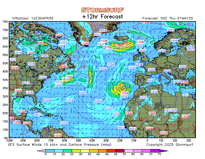
Has anyone else noticed the massive hurricane looking low that the models form in the extreme North Atlantic and then slams into Europe 6 days from now?!
It looks like it hits England around next Thursday as a 984mb storm and it’s pretty big in size
http://www.stormsurfing.com/stormuser2/ ... p_12hr.png
It looks like it hits England around next Thursday as a 984mb storm and it’s pretty big in size
http://www.stormsurfing.com/stormuser2/ ... p_12hr.png
1 likes
Personal Forecast Disclaimer:
The posts in this forum are NOT official forecast and should not be used as such. They are just the opinion of the poster and may or may not be backed by sound meteorological data. They are NOT endorsed by any professional institution or storm2k.org. For official information, please refer to the NHC and NWS products.
The posts in this forum are NOT official forecast and should not be used as such. They are just the opinion of the poster and may or may not be backed by sound meteorological data. They are NOT endorsed by any professional institution or storm2k.org. For official information, please refer to the NHC and NWS products.
-
Extratropical94

- Professional-Met
- Posts: 3545
- Age: 31
- Joined: Wed Oct 20, 2010 6:36 am
- Location: Hamburg, Germany
- Contact:
Re: 2020 Global Model Runs Discussion (Out thru day 16)
eastcoastFL wrote:Has anyone else noticed the massive hurricane looking low that the models form in the extreme North Atlantic and then slams into Europe 6 days from now?!
It looks like it hits England around next Thursday as a 984mb storm and it’s pretty big in size
http://www.stormsurfing.com/stormuser2/ ... p_12hr.png
It also absorbs 96L before that. GFS brings it down to 968 shortly before hitting Ireland, but weakens it into the 980s while crossing Great Britain. The lowest recorded pressure in the UK in August is 967.7 mb btw. Not too shabby for the summer months, could bring hurricane-force gusts to W Ireland, depending on the track.
Hopefully we'll see some cooler temps in C Europe from this system. We hit our 8th consecutive 30C day here in Hamburg yesterday which, believe it or not, is a new record. And yes, I hear you Southerners laughing.
4 likes
54° 11' 59'' N, 9° 9' 20'' E
Boomer Sooner!
Go Broncos! Go Cards!
Clinching counties, one at a time: https://mob-rule.com/user-gifs/USA/xtrp94.gif
- Daniel
Boomer Sooner!
Go Broncos! Go Cards!
Clinching counties, one at a time: https://mob-rule.com/user-gifs/USA/xtrp94.gif
- Daniel
Re: 2020 Global Model Runs Discussion (Out thru day 16)
6z GFS is less enthusiastic about EPac development after the 40/80 major, and still shows the AEW that is at the Lesser Antilles on the 22nd/23rd develop several days later. This time, it takes it into the Gulf.
3 likes
Irene '11 Sandy '12 Hermine '16 5/15/2018 Derecho Fay '20 Isaias '20 Elsa '21 Henri '21 Ida '21
I am only a meteorology enthusiast who knows a decent amount about tropical cyclones. Look to the professional mets, the NHC, or your local weather office for the best information.
I am only a meteorology enthusiast who knows a decent amount about tropical cyclones. Look to the professional mets, the NHC, or your local weather office for the best information.
-
Hurricaneman

- Category 5
- Posts: 7404
- Age: 45
- Joined: Tue Aug 31, 2004 3:24 pm
- Location: central florida
Re: 2020 Global Model Runs Discussion (Out thru day 16)
aspen wrote:6z GFS is less enthusiastic about EPac development after the 40/80 major, and still shows the AEW that is at the Lesser Antilles on the 22nd/23rd develop several days later. This time, it takes it into the Gulf.
Not just that, it has 2 waves in the MDR develop at the end of the run, the GFS is starting to sniff out the true conditions in the Atlantic
3 likes
-
SFLcane
- S2K Supporter
- Posts: 10281
- Age: 48
- Joined: Sat Jun 05, 2010 1:44 pm
- Location: Lake Worth Florida
Re: 2020 Global Model Runs Discussion (Out thru day 16)
Active look of the african coast on the EPS.


4 likes
Who is online
Users browsing this forum: Google [Bot], Google Adsense [Bot], HurricaneFan, JtSmarts and 193 guests