

2021 Global Model Runs Discussion (Out thru day 16)
Moderator: S2k Moderators
Forum rules

The posts in this forum are NOT official forecasts and should not be used as such. They are just the opinion of the poster and may or may not be backed by sound meteorological data. They are NOT endorsed by any professional institution or STORM2K. For official information, please refer to products from the National Hurricane Center and National Weather Service.
Re: 2021 Global Model Runs Discussion (Out thru day 16)
I know these models are way out there, but an uneasy feeling being south of Houston and seeing GFS have you in the crosshairs run after run
0 likes
Harvey,Hanna,Beta,Texas Winter storm2021,Nicholas,Beryl

-
Clearcloudz

- Category 2

- Posts: 540
- Joined: Sun Jun 10, 2018 1:46 pm
- Location: Rosenberg TX


-
Clearcloudz
- Category 2
- Posts: 540
- Joined: Sun Jun 10, 2018 1:46 pm
- Location: Rosenberg TX

Re: 2021 Global Model Runs Discussion (Out thru day 16)
Don't like how the 12Z GFS has very weak steering causing a lot of rain to fall. Luckily the heaviest totals are just off shore but that setup could end very badly if the track is a little different allowing the heaviest rain to fall inland.
0 likes
Re: 2021 Global Model Runs Discussion (Out thru day 16)
Per the 12Z GFS and CMC, that strong AEW over Africa that especially the Euro but also the ICON have been developing on 9/11 just offshore never recurves but instead stays weak and moves WSW in the E Atlantic. You can actually trace the vorticity/precip associated with it on the 12Z GFS then move W all of the way to the Lesser Antilles on 9/17 followed by it moving WNW into the Caribbean but staying very weak.
1 likes
Personal Forecast Disclaimer:
The posts in this forum are NOT official forecasts and should not be used as such. They are just the opinion of the poster and may or may not be backed by sound meteorological data. They are NOT endorsed by any professional institution or storm2k.org. For official information, please refer to the NHC and NWS products.
The posts in this forum are NOT official forecasts and should not be used as such. They are just the opinion of the poster and may or may not be backed by sound meteorological data. They are NOT endorsed by any professional institution or storm2k.org. For official information, please refer to the NHC and NWS products.
-
Clearcloudz
- Category 2
- Posts: 540
- Joined: Sun Jun 10, 2018 1:46 pm
- Location: Rosenberg TX

-
Spacecoast

- Category 2
- Posts: 773
- Joined: Thu Aug 31, 2017 2:03 pm
Re: 2021 Global Model Runs Discussion (Out thru day 16)
LarryWx wrote:Per the 12Z GFS and CMC, that strong AEW over Africa that especially the Euro but also the ICON have been developing on 9/11 just offshore never recurves but instead stays weak and moves WSW in the E Atlantic. You can actually trace the vorticity/precip associated with it on the 12Z GFS then move W all of the way to the Lesser Antilles on 9/17 followed by it moving WNW into the Caribbean but staying very weak.
Edit: I see what you mean. Yes,very weak.
There seems to be some dry air following it.

0 likes
Re: 2021 Global Model Runs Discussion (Out thru day 16)
LarryWx wrote:Per the 12Z GFS and CMC, that strong AEW over Africa that especially the Euro but also the ICON have been developing on 9/11 just offshore never recurves but instead stays weak and moves WSW in the E Atlantic. You can actually trace the vorticity/precip associated with it on the 12Z GFS then move W all of the way to the Lesser Antilles on 9/17 followed by it moving WNW into the Caribbean but staying very weak.
And just like that, the 12Z Euro doesn't recurve it. Instead it starts out like it will recurve, but then it turns back W, then WSW, and then SW while weakening. Also, it comes off about 12 hours earlier than the prior run and closer to the timing of the GFS/CMC though still slower than those. These run to run changes and model differences show me that it is still too early to make a definitive call on what this AEW moving off ~9/11 will or won't do. After all, it is still ~6 days away from the coast and a lot can change before then.
Old Euro run (0Z) is along the African coast moving back inland to the NE:

New Euro run (12) is 400 miles to the WSW about to turn SW and weaken:

0 likes
Personal Forecast Disclaimer:
The posts in this forum are NOT official forecasts and should not be used as such. They are just the opinion of the poster and may or may not be backed by sound meteorological data. They are NOT endorsed by any professional institution or storm2k.org. For official information, please refer to the NHC and NWS products.
The posts in this forum are NOT official forecasts and should not be used as such. They are just the opinion of the poster and may or may not be backed by sound meteorological data. They are NOT endorsed by any professional institution or storm2k.org. For official information, please refer to the NHC and NWS products.
-
gatorcane

- S2K Supporter

- Posts: 23708
- Age: 48
- Joined: Sun Mar 13, 2005 3:54 pm
- Location: Boca Raton, FL
Re: 2021 Global Model Runs Discussion (Out thru day 16)
Today’s 12Z Euro ensemble tracks looking very quiet next 10 days for MDR development and impacts to US / islands:
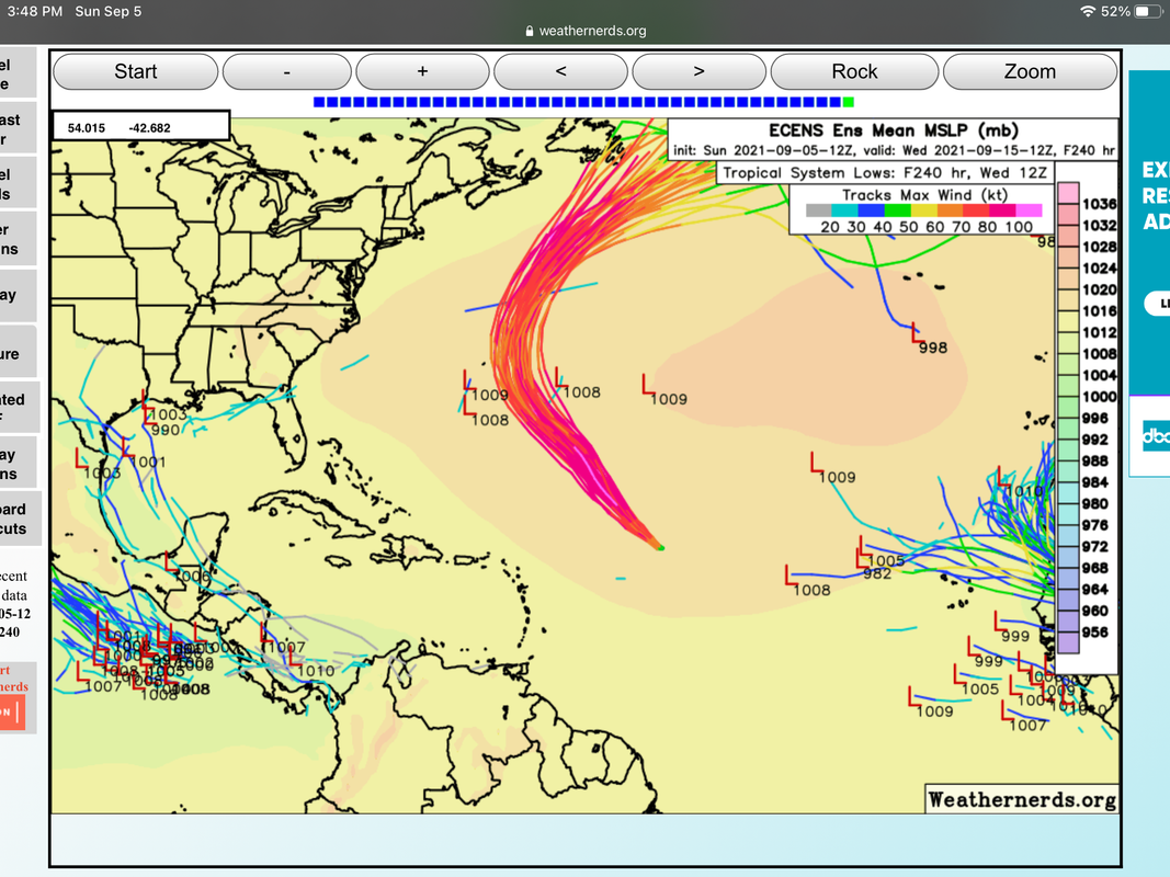
3 likes
Re: 2021 Global Model Runs Discussion (Out thru day 16)
LarryWx wrote:0Z EPS is still very active in the MDR late in the run/something to watch for late Sept:
https://i.imgur.com/fCFhdUC.png
12Z EPS for same time is not nearly as active in the MDR as the 0Z run:

0 likes
Personal Forecast Disclaimer:
The posts in this forum are NOT official forecasts and should not be used as such. They are just the opinion of the poster and may or may not be backed by sound meteorological data. They are NOT endorsed by any professional institution or storm2k.org. For official information, please refer to the NHC and NWS products.
The posts in this forum are NOT official forecasts and should not be used as such. They are just the opinion of the poster and may or may not be backed by sound meteorological data. They are NOT endorsed by any professional institution or storm2k.org. For official information, please refer to the NHC and NWS products.
Re: 2021 Global Model Runs Discussion (Out thru day 16)
gatorcane wrote:Today’s 12Z Euro ensemble tracks looking very quiet next 10 days for MDR development and impacts to US / islands:
https://i.postimg.cc/pVDjmtdK/D2-FFB1-B1-93-BB-4204-9-E1-C-F6535-CB69-C00.png
Indeed, but watch that far eastern MDR AEW, which is due to hit the water ~9/11. With it: still being 6 days out, progged to be quite energetic well inland over Africa by model consensus (probably even now in the middle of Africa), run to run volatility on handling it, model differences, and La Ninaish ENSO, this one's future is far from a done deal. Note that even on the map you showed that there a few members further south which don't recurve and instead move WSW. Although the 12Z run map you showed has many that still recurve sharply, there are more that don't on the 12Z run vs the 0Z run and the mean is much further SW on the 12Z run vs the 0Z run. So, we need to watch to see whether or not that is the start of a new trend on the EPS. Per jconsor, we need to be wary about how the Euro suite handles strong AEWs over W Africa as they tend to make them too strong and thus recurve them too soon in this kind of setup. Backing this up is history: whereas even the 12Z EPS still has quite a few members coming off Africa at 18N+ and sharply recurving as a TS, records back to 1851 don't even have the first one as having done that. Not even one!
Last edited by LarryWx on Sun Sep 05, 2021 4:46 pm, edited 4 times in total.
3 likes
Personal Forecast Disclaimer:
The posts in this forum are NOT official forecasts and should not be used as such. They are just the opinion of the poster and may or may not be backed by sound meteorological data. They are NOT endorsed by any professional institution or storm2k.org. For official information, please refer to the NHC and NWS products.
The posts in this forum are NOT official forecasts and should not be used as such. They are just the opinion of the poster and may or may not be backed by sound meteorological data. They are NOT endorsed by any professional institution or storm2k.org. For official information, please refer to the NHC and NWS products.
-
Category5Kaiju

- Category 5

- Posts: 4336
- Joined: Thu Dec 24, 2020 12:45 pm
- Location: Seattle during the summer, Phoenix during the winter
Re: 2021 Global Model Runs Discussion (Out thru day 16)
For the models that don’t show much in the Atlantic anytime soon, do the same models show more activity in the EPAC, or do they show a quiet EPAC as well?
0 likes
Unless explicitly stated, all information in my posts is based on my own opinions and observations. Tropical storms and hurricanes can be extremely dangerous. Refer to an accredited weather research agency or meteorologist if you need to make serious decisions regarding an approaching storm.
Re: 2021 Global Model Runs Discussion (Out thru day 16)
LarryWx wrote:Per the 12Z GFS and CMC, that strong AEW over Africa that especially the Euro but also the ICON have been developing on 9/11 just offshore never recurves but instead stays weak and moves WSW in the E Atlantic. You can actually trace the vorticity/precip associated with it on the 12Z GFS then move W all of the way to the Lesser Antilles on 9/17 followed by it moving WNW into the Caribbean but staying very weak.
The 18Z GFS is very similar to the 12Z GFS with this AEW emerging from Africa 9/11. By following it closely, once can see that this hour 360 map's convection over the S portion of the FL peninsula down to NC Cuba on 9/20 is actually related to this AEW after a 9 day journey from the African coast:

0 likes
Personal Forecast Disclaimer:
The posts in this forum are NOT official forecasts and should not be used as such. They are just the opinion of the poster and may or may not be backed by sound meteorological data. They are NOT endorsed by any professional institution or storm2k.org. For official information, please refer to the NHC and NWS products.
The posts in this forum are NOT official forecasts and should not be used as such. They are just the opinion of the poster and may or may not be backed by sound meteorological data. They are NOT endorsed by any professional institution or storm2k.org. For official information, please refer to the NHC and NWS products.
Re: 2021 Global Model Runs Discussion (Out thru day 16)
The Euro and GFS both develop Invest 96E but after that that they don't show much perhaps a weak TS but that is about it.Category5Kaiju wrote:For the models that don’t show much in the Atlantic anytime soon, do the same models show more activity in the EPAC, or do they show a quiet EPAC as well?
0 likes
-
Clearcloudz
- Category 2
- Posts: 540
- Joined: Sun Jun 10, 2018 1:46 pm
- Location: Rosenberg TX

-
Category5Kaiju
- Category 5
- Posts: 4336
- Joined: Thu Dec 24, 2020 12:45 pm
- Location: Seattle during the summer, Phoenix during the winter
Re: 2021 Global Model Runs Discussion (Out thru day 16)
IcyTundra wrote:The Euro and GFS both develop Invest 96E but after that that they don't show much perhaps a weak TS but that is about it.Category5Kaiju wrote:For the models that don’t show much in the Atlantic anytime soon, do the same models show more activity in the EPAC, or do they show a quiet EPAC as well?
Yeah, this is what's really suspicious to me; how could both basins be relatively inactive in the month of September? I cannot recall a recent year where September featured meager activity in both basins (and this is regardless of ENSO state as no matter if we're in an El Nino or La Nina, one of the basins should be expected to be active during peak season while the other isn't as much). I personally think the models are missing something, because I cannot wrap my head around why all of a sudden the Atlantic (which is at an impressive 12/5/3 already with nearly 60 ACE) would just falter in September, during a La Nina year of all things too.
7 likes
Unless explicitly stated, all information in my posts is based on my own opinions and observations. Tropical storms and hurricanes can be extremely dangerous. Refer to an accredited weather research agency or meteorologist if you need to make serious decisions regarding an approaching storm.

Re: 2021 Global Model Runs Discussion (Out thru day 16)
Clearcloudz wrote:IcyTundra wrote:00Z GFS can never quite get the potential W Carribean storm going weak TS into TX would be a rain maker.
https://i.imgur.com/we4aEIB.gif
I don't believe this scenario more runs to come but as we move into a phase 3 MJO a strong system is coming somewhere along the gulf coast.
Word. Phase 3 looks to last a little longer than the models were showing last week. All bets are always off in 3.
1 likes
Re: 2021 Global Model Runs Discussion (Out thru day 16)
Category5Kaiju wrote:IcyTundra wrote:The Euro and GFS both develop Invest 96E but after that that they don't show much perhaps a weak TS but that is about it.Category5Kaiju wrote:For the models that don’t show much in the Atlantic anytime soon, do the same models show more activity in the EPAC, or do they show a quiet EPAC as well?
Yeah, this is what's really suspicious to me; how could both basins be relatively inactive in the month of September? I cannot recall a recent year where September featured meager activity in both basins (and this is regardless of ENSO state as no matter if we're in an El Nino or La Nina, one of the basins should be expected to be active during peak season while the other isn't as much). I personally think the models are missing something, because I cannot wrap my head around why all of a sudden the Atlantic (which is at an impressive 12/5/3 already with nearly 60 ACE) would just falter in September, during a La Nina year of all things too.
The global models are almost certainly going to be wrong. I can see a bit of lull like the models are showing but I doubt it will be for nearly the entire month like the GFS and Euro want us to believe. Climatology and a likely transistion to La Nina will be more than enough to prove the models wrong.
0 likes
Re: 2021 Global Model Runs Discussion (Out thru day 16)
00Z GFS

The setup in the Carribean for next week kind of reminds me of Ida when it was in the Carribean. The big thing to watch is going to be whether or not it can spin up further north than the GFS has been indicating in today's runs.
The setup in the Carribean for next week kind of reminds me of Ida when it was in the Carribean. The big thing to watch is going to be whether or not it can spin up further north than the GFS has been indicating in today's runs.
2 likes
Who is online
Users browsing this forum: No registered users and 124 guests