2021 Global Model Runs Discussion (Out thru day 16)
Moderator: S2k Moderators
Forum rules
The posts in this forum are NOT official forecasts and should not be used as such. They are just the opinion of the poster and may or may not be backed by sound meteorological data. They are NOT endorsed by any professional institution or STORM2K. For official information, please refer to products from the National Hurricane Center and National Weather Service.
- Hurricaneman
- Category 5

- Posts: 7404
- Age: 45
- Joined: Tue Aug 31, 2004 3:24 pm
- Location: central florida
Re: 2021 Global Model Runs Discussion (Out thru day 16)
The 0zGFS also has a system come off Africa in 5 or so days and become a tropical cyclone near the CV islands but dissipates it as it nears the lesser Antilles, I really feel that this area will be one to watch long term
2 likes
Re: 2021 Global Model Runs Discussion (Out thru day 16)
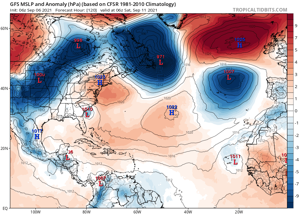
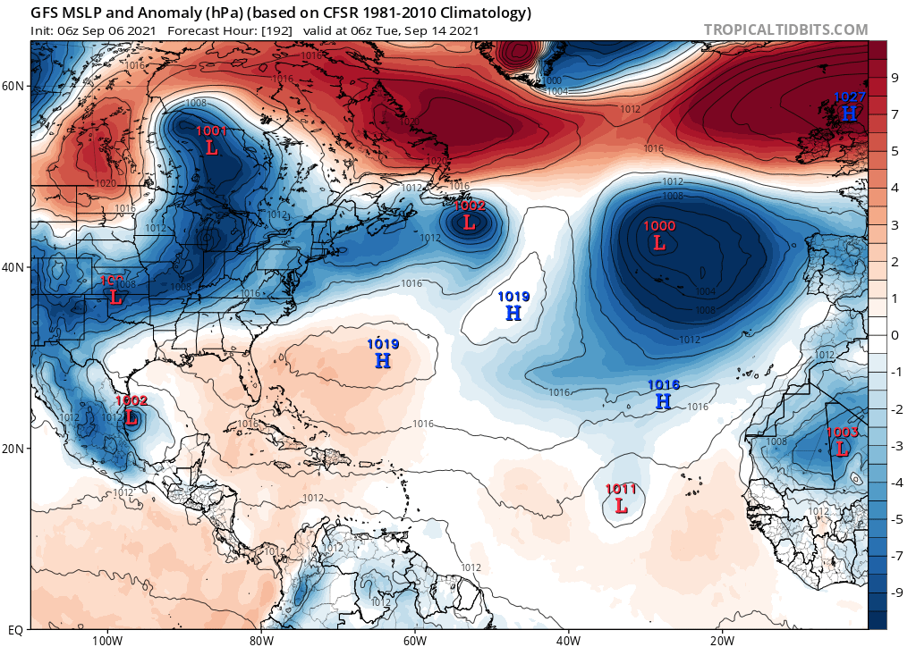
Posting the entire 00Z GFS run because of how ridiculous it is. No way it happens like this but I just want to document it because of how crazy it is.


0 likes
Re: 2021 Global Model Runs Discussion (Out thru day 16)
Hurricaneman wrote:The 0zGFS also has a system come off Africa in 5 or so days and become a tropical cyclone near the CV islands but dissipates it as it nears the lesser Antilles, I really feel that this area will be one to watch long term
This shows up in the animation in the post above as a semi-organized batch of convection coming from the right side at hour 252 and then moving WNW into the NE Caribbean and over the Greater Antilles. This is the same strong AEW currently over central Africa that the models have for many days been having move off 9/10-11 and becoming a TC almost immediately on a number of Euro and Icon runs. This is the strongest I can recall on the GFS. Even though it weakens, it is now the 3rd GFS run in a row with a trackable AEW getting into the Caribbean 9/17 and is the most energetic it has been when getting there (strong wave). This once again gets to Cuba/FL Straits/S FL late on 9/20 and tells me once again that this could conceivably threaten the Caribbean ~9/17-20 followed by the CONUS starting ~9/20.
Climo says that a scenario like this isn’t at all far-fetched for an AEW moving off ~9/10, especially in La Niña.
1 likes
Personal Forecast Disclaimer:
The posts in this forum are NOT official forecasts and should not be used as such. They are just the opinion of the poster and may or may not be backed by sound meteorological data. They are NOT endorsed by any professional institution or storm2k.org. For official information, please refer to the NHC and NWS products.
The posts in this forum are NOT official forecasts and should not be used as such. They are just the opinion of the poster and may or may not be backed by sound meteorological data. They are NOT endorsed by any professional institution or storm2k.org. For official information, please refer to the NHC and NWS products.
- Category5Kaiju
- Category 5

- Posts: 4336
- Joined: Thu Dec 24, 2020 12:45 pm
- Location: Seattle during the summer, Phoenix during the winter
Re: 2021 Global Model Runs Discussion (Out thru day 16)
So at least the GFS is beginning to show decent signs of life through this month; to be honest, this is not surprising at all imho, it was just a matter of time before the GFS realized that we are not in an El Niño and we have a potent WAM in place. Between 91L (even in the Central Atlantic), the potential Gulf storm next week, and the waves in the MDR that could go on to develop further west, I am still firmly clinging to the idea that we are going to see at least 4-5 NSs before this month comes to a close.
1 likes
Unless explicitly stated, all information in my posts is based on my own opinions and observations. Tropical storms and hurricanes can be extremely dangerous. Refer to an accredited weather research agency or meteorologist if you need to make serious decisions regarding an approaching storm.
-
AlphaToOmega
- Category 5

- Posts: 1448
- Joined: Sat Jun 26, 2021 10:51 am
- Location: Somewhere in Massachusetts
Re: 2021 Global Model Runs Discussion (Out thru day 16)
GFS showing two storms before September 15 (Mindy and Nicholas)


1 likes
- Clearcloudz
- Category 2

- Posts: 540
- Joined: Sun Jun 10, 2018 1:46 pm
- Location: Rosenberg TX
Re: 2021 Global Model Runs Discussion (Out thru day 16)
Crickets on the ECENS ensemble members regarding this disturbance coming from the Caribbean while the GEFS enemble members have stuff forming 42 hours from now.
GEFS 42 hours from now

ECENS 42 hours from now

GEFS ensemble run

GEFS 42 hours from now

ECENS 42 hours from now

GEFS ensemble run

1 likes
- SFLcane
- S2K Supporter

- Posts: 10281
- Age: 48
- Joined: Sat Jun 05, 2010 1:44 pm
- Location: Lake Worth Florida
Re: 2021 Global Model Runs Discussion (Out thru day 16)
Maybe it’s me but I was expecting more activity in the long guidance considering we’re nearing peak Climo. I guess we’ll see
0 likes
- SFLcane
- S2K Supporter

- Posts: 10281
- Age: 48
- Joined: Sat Jun 05, 2010 1:44 pm
- Location: Lake Worth Florida
Re: 2021 Global Model Runs Discussion (Out thru day 16)
Gfs is trying…actually has the wave the euro quickly recurves moving SW. A TS over Africa is BS as the euro shows


4 likes
- SFLcane
- S2K Supporter

- Posts: 10281
- Age: 48
- Joined: Sat Jun 05, 2010 1:44 pm
- Location: Lake Worth Florida
Re: 2021 Global Model Runs Discussion (Out thru day 16)
It will be interesting to see if it actually dips SW.


4 likes
Re: 2021 Global Model Runs Discussion (Out thru day 16)
The GFS and Cdn models have been pretty consistent on showing something coming for the Mexico/Texas coastline.
I would be interested in what the groups thoughts are?
I would be interested in what the groups thoughts are?
1 likes
Harvey,Hanna,Beta,Texas Winter storm2021,Nicholas,Beryl
- Clearcloudz
- Category 2

- Posts: 540
- Joined: Sun Jun 10, 2018 1:46 pm
- Location: Rosenberg TX
Re: 2021 Global Model Runs Discussion (Out thru day 16)
The 6Z GFS/GEFS and EPS are continuing the idea that the AEW moving offshore Africa 9/10 (GFS) or 9/11 (Euro) (is the same AEW) may very well eventually be something to contend with. The 6Z GFS is the 4th run in a row that gets it near FL ~9/20. Also, this run suggests there may be another active wave a few days behind it. Also, note the strong E US ridge being suggested for around that period, something fairly common late Sep into early Oct in La Niña.
3 likes
Personal Forecast Disclaimer:
The posts in this forum are NOT official forecasts and should not be used as such. They are just the opinion of the poster and may or may not be backed by sound meteorological data. They are NOT endorsed by any professional institution or storm2k.org. For official information, please refer to the NHC and NWS products.
The posts in this forum are NOT official forecasts and should not be used as such. They are just the opinion of the poster and may or may not be backed by sound meteorological data. They are NOT endorsed by any professional institution or storm2k.org. For official information, please refer to the NHC and NWS products.
Re: 2021 Global Model Runs Discussion (Out thru day 16)
Looks like the ensemble is slowly coming to life. I was already quite baffled the last few days just how little activity GFS and the euro showed considering we're at peak season with above average SSTs, generally conductive conditions and considering that the season so far has already been very active. Still not a lot of activity, but it could be a prelude for the rest of September, we'll have to wait and see. Also it looks like a few of the African wave members make the infamous SW dip near the end of the run.
1 likes
- Clearcloudz
- Category 2

- Posts: 540
- Joined: Sun Jun 10, 2018 1:46 pm
- Location: Rosenberg TX
Re: 2021 Global Model Runs Discussion (Out thru day 16)
kevin wrote:
Looks like the ensemble is slowly coming to life. I was already quite baffled the last few days just how little activity GFS and the euro showed considering we're at peak season with above average SSTs, generally conductive conditions and considering that the season so far has already been very active. Still not a lot of activity, but it could be a prelude for the rest of September, we'll have to wait and see. Also it looks like a few of the African wave members make the infamous SW dip near the end of the run.
GEFS has been by far a go to model when it comes to tropical genesis. Euro tends to be more conservative but eventually catches up to the other models.
0 likes
Re: 2021 Global Model Runs Discussion (Out thru day 16)
Clearcloudz wrote:kevin wrote:
Looks like the ensemble is slowly coming to life. I was already quite baffled the last few days just how little activity GFS and the euro showed considering we're at peak season with above average SSTs, generally conductive conditions and considering that the season so far has already been very active. Still not a lot of activity, but it could be a prelude for the rest of September, we'll have to wait and see. Also it looks like a few of the African wave members make the infamous SW dip near the end of the run.
GEFS has been by far a go to model when it comes to tropical genesis. Euro tends to be more conservative but eventually catches up to the other models.
Agreed. Then when it catches up it can do a decent job with track.
0 likes
Re: 2021 Global Model Runs Discussion (Out thru day 16)
Here we go regarding that same AEW moving off Africa ~9/11:
1. ICON has it stronger and further out than earlier runs as it moves west at the end of the run. It is already pretty far north at 20N, which would suggest a good chance at an early recurve, but keep in mind that the models are jumping around as they try to figure out how strong this AEW will be and where it will track as evidenced by lots of run to run changes

2. UKMET finally has it as it just moved to within its 144 hour range. This track, too, would mean a likely early recurve but note that this has it a TS right off Africa and a near H within 24 hours, both of which could be too strong:
NEW TROPICAL CYCLONE FORECAST TO DEVELOP AFTER 120 HOURS
FORECAST POSITION AT T+120 : 15.6N 15.7W
LEAD CENTRAL MAXIMUM WIND
VERIFYING TIME TIME POSITION PRESSURE (MB) SPEED (KNOTS)
-------------- ---- -------- ------------- -------------
1200UTC 11.09.2021 120 15.6N 15.7W 998 39
0000UTC 12.09.2021 132 17.3N 18.7W 992 50
1200UTC 12.09.2021 144 18.9N 20.6W 983 57
1. ICON has it stronger and further out than earlier runs as it moves west at the end of the run. It is already pretty far north at 20N, which would suggest a good chance at an early recurve, but keep in mind that the models are jumping around as they try to figure out how strong this AEW will be and where it will track as evidenced by lots of run to run changes

2. UKMET finally has it as it just moved to within its 144 hour range. This track, too, would mean a likely early recurve but note that this has it a TS right off Africa and a near H within 24 hours, both of which could be too strong:
NEW TROPICAL CYCLONE FORECAST TO DEVELOP AFTER 120 HOURS
FORECAST POSITION AT T+120 : 15.6N 15.7W
LEAD CENTRAL MAXIMUM WIND
VERIFYING TIME TIME POSITION PRESSURE (MB) SPEED (KNOTS)
-------------- ---- -------- ------------- -------------
1200UTC 11.09.2021 120 15.6N 15.7W 998 39
0000UTC 12.09.2021 132 17.3N 18.7W 992 50
1200UTC 12.09.2021 144 18.9N 20.6W 983 57
3 likes
Personal Forecast Disclaimer:
The posts in this forum are NOT official forecasts and should not be used as such. They are just the opinion of the poster and may or may not be backed by sound meteorological data. They are NOT endorsed by any professional institution or storm2k.org. For official information, please refer to the NHC and NWS products.
The posts in this forum are NOT official forecasts and should not be used as such. They are just the opinion of the poster and may or may not be backed by sound meteorological data. They are NOT endorsed by any professional institution or storm2k.org. For official information, please refer to the NHC and NWS products.
- cheezyWXguy
- Category 5

- Posts: 6282
- Joined: Mon Feb 13, 2006 12:29 am
- Location: Dallas, TX
Re: 2021 Global Model Runs Discussion (Out thru day 16)
12z gfs pushes the BOC system onshore just as it is beginning to strengthen. Track and strength are going to depend on 2 factors: 1) how far north or south does the initial area of vorticity consolidate before moving into the Yucatán and 2) how fast does the trough move in that would lift this north?
5 likes
- SFLcane
- S2K Supporter

- Posts: 10281
- Age: 48
- Joined: Sat Jun 05, 2010 1:44 pm
- Location: Lake Worth Florida
Re: 2021 Global Model Runs Discussion (Out thru day 16)
3 potential systems on the Canadian.


3 likes
Who is online
Users browsing this forum: No registered users and 100 guests


