2020 Indicators: SST's / SAL / MSLP / Steering / Shear / Instability / Sat Images

This is the general tropical discussion area. Anyone can take their shot at predicting a storms path.

Moderator: S2k Moderators

Forum rules

The posts in this forum are NOT official forecasts and should not be used as such. They are just the opinion of the poster and may or may not be backed by sound meteorological data. They are NOT endorsed by any professional institution or STORM2K. For official information, please refer to products from the National Hurricane Center and National Weather Service.

Help Support Storm2K
Message
Author
Nuno
Category 2
Category 2
Posts: 597
Joined: Fri Aug 30, 2019 8:35 am
Location: Coral Gables, FL

Re: 2020 Indicators: SST's / SAL / MSLP / Steering / Shear / Instability / Sat Images

#1341 Postby Nuno » Sun Jul 05, 2020 3:08 pm

Shell Mound wrote:So to be sure that 2020 will be hyperactive, in addition to the next few formations in the subtropics, we need at least one or two MDR formations before July ends.


Why? Not having a go, but this seems entirely arbitrary. Why not one or two in the Gulf or BoC? Or in the subtropics? Is this because you figure MDR storms would accumulate more ACE than the usual locations where July storms would form?
1 likes   
Andrew (1992), Irene (1999), Frances (2004), Katrina (2005), Wilma (2005), Fay (2008), Irma (2017), Eta (2020), Ian (2022)

User avatar
aspen
Category 5
Category 5
Posts: 8818
Joined: Sat Oct 12, 2019 7:10 pm
Location: Connecticut, USA

Re: 2020 Indicators: SST's / SAL / MSLP / Steering / Shear / Instability / Sat Images

#1342 Postby aspen » Sun Jul 05, 2020 3:24 pm

MoliNuno wrote:
Shell Mound wrote:So to be sure that 2020 will be hyperactive, in addition to the next few formations in the subtropics, we need at least one or two MDR formations before July ends.


Why? Not having a go, but this seems entirely arbitrary. Why not one or two in the Gulf or BoC? Or in the subtropics? Is this because you figure MDR storms would accumulate more ACE than the usual locations where July storms would form?

It doesn’t have to be in the MDR, but there is a bit of a correlation between the presence of AEW-based July systems and an above-average Atlantic hurricane season. Seasons with a July system formed from a tropical wave tend to be more active than those with a system formed from other methods.
3 likes   
Irene '11 Sandy '12 Hermine '16 5/15/2018 Derecho Fay '20 Isaias '20 Elsa '21 Henri '21 Ida '21

I am only a meteorology enthusiast who knows a decent amount about tropical cyclones. Look to the professional mets, the NHC, or your local weather office for the best information.

BYG Jacob

Re: 2020 Indicators: SST's / SAL / MSLP / Steering / Shear / Instability / Sat Images

#1343 Postby BYG Jacob » Sun Jul 05, 2020 3:33 pm

I would just like to point out it is currently July 5th.
10 likes   

MarioProtVI
Category 4
Category 4
Posts: 935
Age: 24
Joined: Sun Sep 29, 2019 7:33 pm
Location: New Jersey

Re: 2020 Indicators: SST's / SAL / MSLP / Steering / Shear / Instability / Sat Images

#1344 Postby MarioProtVI » Sun Jul 05, 2020 8:14 pm

Given the rate at which the Atlantic has been spitting out weak, short lived storms within the past week or so I am currently questioning if 2020 will be as hyperactive as initially predicted. One reason why I believe this is when looking at the current SSTA setup, there is a large warm blob right next to Africa which is considerably warmer then the MDR, along with cool anomalies both north and to the south of it. I am starting to think that if this persists, this may offset the otherwise favorable conditions in the MDR and actually suppress activity even if the MDR is a bit above average. 2013 had that warm blob that close too and look what happened. Even if this does not come to fruition, 2020 may end up with a hurricane minority similar to 2011 and 2019, with totals probably more close to say 19-7-4 which is a bit sick.
Image
3 likes   

User avatar
toad strangler
S2K Supporter
S2K Supporter
Posts: 4543
Joined: Sun Jul 28, 2013 3:09 pm
Location: Earth
Contact:

Re: 2020 Indicators: SST's / SAL / MSLP / Steering / Shear / Instability / Sat Images

#1345 Postby toad strangler » Sun Jul 05, 2020 8:18 pm

MarioProtVI wrote:Given the rate at which the Atlantic has been spitting out weak, short lived storms within the past week or so I am currently questioning if 2020 will be as hyperactive as initially predicted. One reason why I believe this is when looking at the current SSTA setup, there is a large warm blob right next to Africa which is considerably warmer then the MDR, along with cool anomalies both north and to the south of it. I am starting to think that if this persists, this may offset the otherwise favorable conditions in the MDR and actually suppress activity even if the MDR is a bit above average. 2013 had that warm blob that close too and look what happened. Even if this does not come to fruition, 2020 may end up with a hurricane minority similar to 2011 and 2019, with totals probably more close to say 19-7-4 which is a bit sick.
https://coralreefwatch.noaa.gov/data/5km/v3.1/image/daily/ssta/gif/2020/coraltemp5km_ssta_20200704_large.gif


Early season storms have no bearing on 8/15 forward.
10 likes   

zhukm29
Category 1
Category 1
Posts: 279
Joined: Tue Aug 28, 2018 2:37 pm

Re: 2020 Indicators: SST's / SAL / MSLP / Steering / Shear / Instability / Sat Images

#1346 Postby zhukm29 » Sun Jul 05, 2020 8:27 pm

MarioProtVI wrote:Given the rate at which the Atlantic has been spitting out weak, short lived storms within the past week or so I am currently questioning if 2020 will be as hyperactive as initially predicted. One reason why I believe this is when looking at the current SSTA setup, there is a large warm blob right next to Africa which is considerably warmer then the MDR, along with cool anomalies both north and to the south of it. I am starting to think that if this persists, this may offset the otherwise favorable conditions in the MDR and actually suppress activity even if the MDR is a bit above average. 2013 had that warm blob that close too and look what happened. Even if this does not come to fruition, 2020 may end up with a hurricane minority similar to 2011 and 2019, with totals probably more close to say 19-7-4 which is a bit sick.
https://coralreefwatch.noaa.gov/data/5km/v3.1/image/daily/ssta/gif/2020/coraltemp5km_ssta_20200704_large.gif


You may be right, but the difference between 2020 and most other years is the fact that it has been spitting out storms this early in general, especially since July just started! Also, even if 2013 had the same warm blob, the blob wasn't the reason why 2013 was so inactive; 2013 had an anomalous weakening of the the Atlantic thermohaline circulation, as well as high wind shear and atmospheric stability across the entire basin. 2013 was an extremely rare event, and all the indicators are pointing to an active season so far.

Also, storms being weak now doesn't provide any information about the rest of the season; they're weak because it's currently July 5. I remember a lot of people were comparing 2017 with 2013 when the first five storms had the lowest ACE on record, and we ended up getting hit with the costliest season on record. It's important to stay vigilant, especially given 2020's track record so far...

That being said, I wouldn't be sad if this year ended up being like 2013, since the world has enough to deal with already. But right now it seems like an unrealistic dream. :)
12 likes   

CYCLONE MIKE
Category 5
Category 5
Posts: 2183
Joined: Tue Aug 31, 2004 6:04 pm
Location: Gonzales, LA

Re: 2020 Indicators: SST's / SAL / MSLP / Steering / Shear / Instability / Sat Images

#1347 Postby CYCLONE MIKE » Sun Jul 05, 2020 8:58 pm

toad strangler wrote:
MarioProtVI wrote:Given the rate at which the Atlantic has been spitting out weak, short lived storms within the past week or so I am currently questioning if 2020 will be as hyperactive as initially predicted. One reason why I believe this is when looking at the current SSTA setup, there is a large warm blob right next to Africa which is considerably warmer then the MDR, along with cool anomalies both north and to the south of it. I am starting to think that if this persists, this may offset the otherwise favorable conditions in the MDR and actually suppress activity even if the MDR is a bit above average. 2013 had that warm blob that close too and look what happened. Even if this does not come to fruition, 2020 may end up with a hurricane minority similar to 2011 and 2019, with totals probably more close to say 19-7-4 which is a bit sick.
https://coralreefwatch.noaa.gov/data/5km/v3.1/image/daily/ssta/gif/2020/coraltemp5km_ssta_20200704_large.gif


Early season storms have no bearing on 8/15 forward.


Also the total number so far has no bearing that things will get busier when august comes around. They might, they might not. Might just continue with the way things have been with weak short lived storms the remainder of the season. No one knows. So just because someone might want to change their thinking because of the way things have gone so far doesn’t make them wrong.
1 likes   

User avatar
toad strangler
S2K Supporter
S2K Supporter
Posts: 4543
Joined: Sun Jul 28, 2013 3:09 pm
Location: Earth
Contact:

Re: 2020 Indicators: SST's / SAL / MSLP / Steering / Shear / Instability / Sat Images

#1348 Postby toad strangler » Sun Jul 05, 2020 9:28 pm

CYCLONE MIKE wrote:
toad strangler wrote:
MarioProtVI wrote:Given the rate at which the Atlantic has been spitting out weak, short lived storms within the past week or so I am currently questioning if 2020 will be as hyperactive as initially predicted. One reason why I believe this is when looking at the current SSTA setup, there is a large warm blob right next to Africa which is considerably warmer then the MDR, along with cool anomalies both north and to the south of it. I am starting to think that if this persists, this may offset the otherwise favorable conditions in the MDR and actually suppress activity even if the MDR is a bit above average. 2013 had that warm blob that close too and look what happened. Even if this does not come to fruition, 2020 may end up with a hurricane minority similar to 2011 and 2019, with totals probably more close to say 19-7-4 which is a bit sick.
https://coralreefwatch.noaa.gov/data/5km/v3.1/image/daily/ssta/gif/2020/coraltemp5km_ssta_20200704_large.gif


Early season storms have no bearing on 8/15 forward.


Also the total number so far has no bearing that things will get busier when august comes around. They might, they might not. Might just continue with the way things have been with weak short lived storms the remainder of the season. No one knows. So just because someone might want to change their thinking because of the way things have gone so far doesn’t make them wrong.


Cool. You do you. I'll do me and It is my opinion that changing thinking based on early activity is fubar given many available multiple indicators. We'll see.
2 likes   

AutoPenalti
Category 5
Category 5
Posts: 4030
Age: 29
Joined: Mon Aug 17, 2015 4:16 pm
Location: Ft. Lauderdale, Florida

Re: 2020 Indicators: SST's / SAL / MSLP / Steering / Shear / Instability / Sat Images

#1349 Postby AutoPenalti » Sun Jul 05, 2020 9:41 pm

Did anyone here predict Irma, Maria, Jose, and Katia before July? No.

2020 is still ongoing and predicting that this will be another 2013 is a huge task.
2 likes   
The posts in this forum are NOT official forecasts and should not be used as such. They are just the opinion of the poster and may or may not be backed by sound meteorological data. They are NOT endorsed by any professional institution or STORM2K. For official information, please refer to products from the NHC and NWS.


Model Runs Cheat Sheet:
GFS (5:30 AM/PM, 11:30 AM/PM)
HWRF, GFDL, UKMET, NAVGEM (6:30-8:00 AM/PM, 12:30-2:00 AM/PM)
ECMWF (1:45 AM/PM)

TCVN
is a weighted averaged

User avatar
Hammy
Category 5
Category 5
Posts: 5849
Age: 42
Joined: Fri May 25, 2012 5:25 pm
Contact:

Re: 2020 Indicators: SST's / SAL / MSLP / Steering / Shear / Instability / Sat Images

#1350 Postby Hammy » Sun Jul 05, 2020 9:45 pm

It's kind of interesting that people are dismissing the season because we've had a lot of weak storms when the discussion would be different had only Arthur and Cristobal formed by this point--all these relatively weaker storms (which are all over-performing I might add) continue to prove that the background conditions are much more favorable than the last few years--at the very least the last two--and that the models are having difficulty foreseeing development more than a day or two out.
12 likes   
The above post is not official and should not be used as such. It is the opinion of the poster and may or may not be backed by sound meteorological data. It is not endorsed by any professional institution or storm2k.org. For official information, please refer to the NHC and NWS products.

MarioProtVI
Category 4
Category 4
Posts: 935
Age: 24
Joined: Sun Sep 29, 2019 7:33 pm
Location: New Jersey

Re: 2020 Indicators: SST's / SAL / MSLP / Steering / Shear / Instability / Sat Images

#1351 Postby MarioProtVI » Sun Jul 05, 2020 9:55 pm

CYCLONE MIKE wrote:
toad strangler wrote:
MarioProtVI wrote:Given the rate at which the Atlantic has been spitting out weak, short lived storms within the past week or so I am currently questioning if 2020 will be as hyperactive as initially predicted. One reason why I believe this is when looking at the current SSTA setup, there is a large warm blob right next to Africa which is considerably warmer then the MDR, along with cool anomalies both north and to the south of it. I am starting to think that if this persists, this may offset the otherwise favorable conditions in the MDR and actually suppress activity even if the MDR is a bit above average. 2013 had that warm blob that close too and look what happened. Even if this does not come to fruition, 2020 may end up with a hurricane minority similar to 2011 and 2019, with totals probably more close to say 19-7-4 which is a bit sick.
https://coralreefwatch.noaa.gov/data/5km/v3.1/image/daily/ssta/gif/2020/coraltemp5km_ssta_20200704_large.gif


Early season storms have no bearing on 8/15 forward.


Also the total number so far has no bearing that things will get busier when august comes around. They might, they might not. Might just continue with the way things have been with weak short lived storms the remainder of the season. No one knows. So just because someone might want to change their thinking because of the way things have gone so far doesn’t make them wrong.

Exactly, and even if we have an activity uptick at peak it’s looking more likely 2020 could have a hurricane deficit/minority if the Atlantic keeps spitting out weak short lived storms.
1 likes   

User avatar
toad strangler
S2K Supporter
S2K Supporter
Posts: 4543
Joined: Sun Jul 28, 2013 3:09 pm
Location: Earth
Contact:

Re: 2020 Indicators: SST's / SAL / MSLP / Steering / Shear / Instability / Sat Images

#1352 Postby toad strangler » Sun Jul 05, 2020 9:56 pm

MarioProtVI wrote:
CYCLONE MIKE wrote:
toad strangler wrote:

Early season storms have no bearing on 8/15 forward.


Also the total number so far has no bearing that things will get busier when august comes around. They might, they might not. Might just continue with the way things have been with weak short lived storms the remainder of the season. No one knows. So just because someone might want to change their thinking because of the way things have gone so far doesn’t make them wrong.

Exactly, and even if we have an activity uptick at peak it’s looking more likely 2020 could have a hurricane deficit/minority if the Atlantic keeps spitting out weak short lived storms.


:lol:
7 likes   

User avatar
toad strangler
S2K Supporter
S2K Supporter
Posts: 4543
Joined: Sun Jul 28, 2013 3:09 pm
Location: Earth
Contact:

Re: 2020 Indicators: SST's / SAL / MSLP / Steering / Shear / Instability / Sat Images

#1353 Postby toad strangler » Sun Jul 05, 2020 9:57 pm

Hammy wrote:It's kind of interesting that people are dismissing the season because we've had a lot of weak storms when the discussion would be different had only Arthur and Cristobal formed by this point--all these relatively weaker storms (which are all over-performing I might add) continue to prove that the background conditions are much more favorable than the last few years--at the very least the last two--and that the models are having difficulty foreseeing development more than a day or two out.


I'm taking names :wink:
0 likes   

User avatar
Hammy
Category 5
Category 5
Posts: 5849
Age: 42
Joined: Fri May 25, 2012 5:25 pm
Contact:

Re: 2020 Indicators: SST's / SAL / MSLP / Steering / Shear / Instability / Sat Images

#1354 Postby Hammy » Sun Jul 05, 2020 10:01 pm

MarioProtVI wrote:Given the rate at which the Atlantic has been spitting out weak, short lived storms within the past week or so I am currently questioning if 2020 will be as hyperactive as initially predicted. One reason why I believe this is when looking at the current SSTA setup, there is a large warm blob right next to Africa which is considerably warmer then the MDR, along with cool anomalies both north and to the south of it. I am starting to think that if this persists, this may offset the otherwise favorable conditions in the MDR and actually suppress activity even if the MDR is a bit above average. 2013 had that warm blob that close too and look what happened. Even if this does not come to fruition, 2020 may end up with a hurricane minority similar to 2011 and 2019, with totals probably more close to say 19-7-4 which is a bit sick.
https://coralreefwatch.noaa.gov/data/5km/v3.1/image/daily/ssta/gif/2020/coraltemp5km_ssta_20200704_large.gif


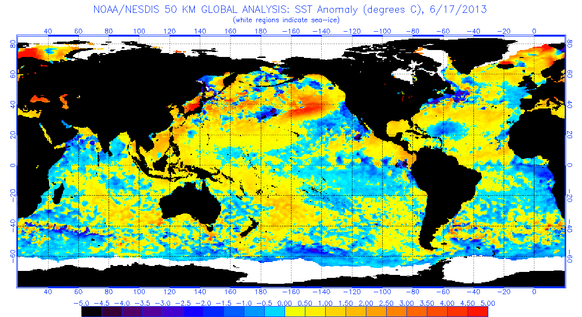
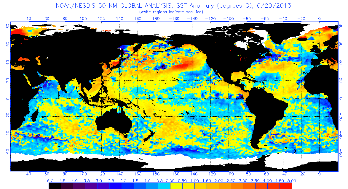
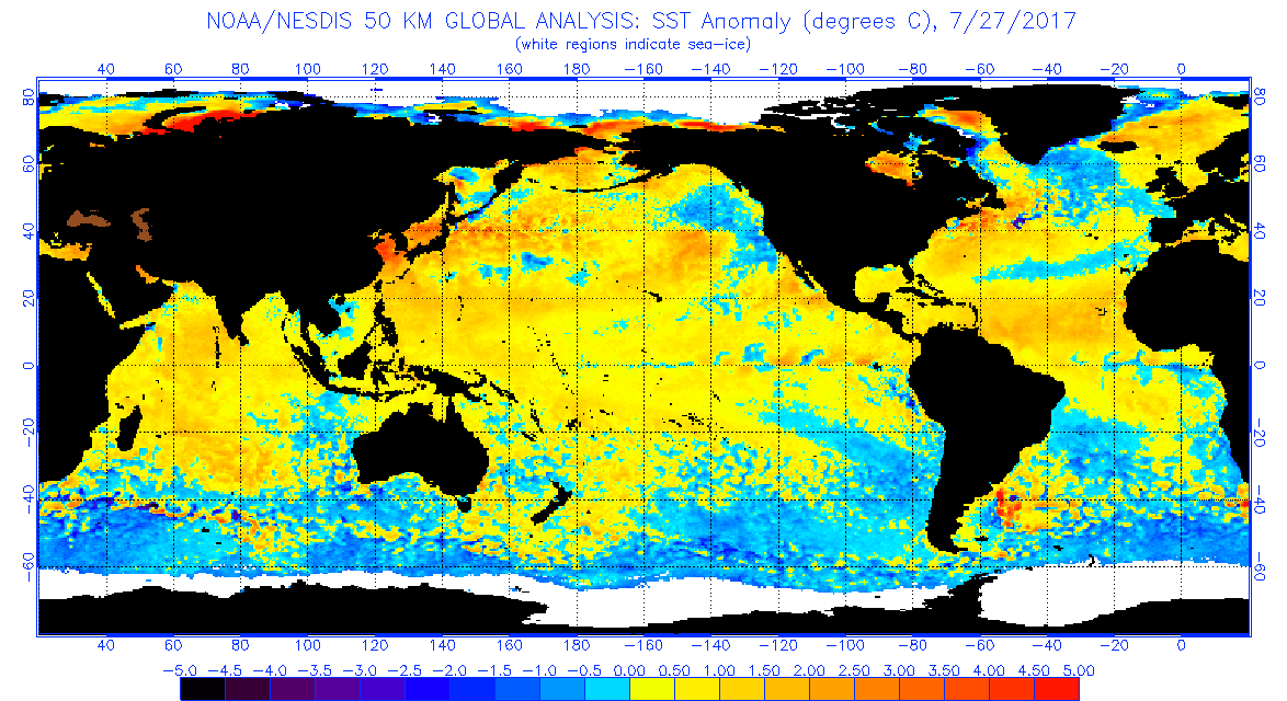
2013 was the result of a weakening of the thermohaline circulation and should not be used as a comparison--that was an extreme anomaly and has MUCH cooler and wetter conditions along the southeast and midwest from the same setup, which kept the atmospheric conditions in spring (which is not the case this year. SST pattern even showed the Gulf Stream having little to no signature off the east coast and large areas of cold water upwelling that don't fit any real pattern.

Image
Image

The current pattern, by contrast, is fairly similar to August 2017.

Image
Image
3 likes   
The above post is not official and should not be used as such. It is the opinion of the poster and may or may not be backed by sound meteorological data. It is not endorsed by any professional institution or storm2k.org. For official information, please refer to the NHC and NWS products.

User avatar
Ubuntwo
Category 5
Category 5
Posts: 1406
Age: 31
Joined: Thu Oct 05, 2017 10:41 pm

Re: 2020 Indicators: SST's / SAL / MSLP / Steering / Shear / Instability / Sat Images

#1355 Postby Ubuntwo » Sun Jul 05, 2020 10:15 pm

Just put this together. SSTA comparison, 2020 vs 2017 vs 2005 vs 2004. Same methodology and everything. (one day off cause I didn't know the July 5th data wasn't yet available. Won't make a difference.)
Image
7 likes   
Kendall -> SLO -> PBC

Memorable Storms: Katrina (for its Florida landfall...) Wilma Matthew Irma

HurricaneFrances04
Category 2
Category 2
Posts: 597
Joined: Mon Jun 25, 2012 8:09 am
Location: Fort Lauderdale, Florida

Re: 2020 Indicators: SST's / SAL / MSLP / Steering / Shear / Instability / Sat Images

#1356 Postby HurricaneFrances04 » Sun Jul 05, 2020 10:18 pm

Was always under the impression that warm anomalies between EQ and 20N with cool anomalies to the north was a favorable set up in the MDR.
2 likes   

User avatar
Ubuntwo
Category 5
Category 5
Posts: 1406
Age: 31
Joined: Thu Oct 05, 2017 10:41 pm

Re: 2020 Indicators: SST's / SAL / MSLP / Steering / Shear / Instability / Sat Images

#1357 Postby Ubuntwo » Sun Jul 05, 2020 10:20 pm

HurricaneFrances04 wrote:Was always under the impression that warm anomalies between EQ and 20N with cool anomalies to the north was a favorable set up in the MDR.

Yeah, look at the chart above for comparison to hyperactive years. SST profile is closest to 2017, though the MDR is a bit warmer. Or 2005 with a cooler MDR your choice.
0 likes   
Kendall -> SLO -> PBC

Memorable Storms: Katrina (for its Florida landfall...) Wilma Matthew Irma

Shell Mound
Category 5
Category 5
Posts: 2434
Age: 32
Joined: Thu Sep 07, 2017 3:39 pm
Location: St. Petersburg, FL → Scandinavia

Re: 2020 Indicators: SST's / SAL / MSLP / Steering / Shear / Instability / Sat Images

#1358 Postby Shell Mound » Sun Jul 05, 2020 10:21 pm

HurricaneFrances04 wrote:Was always under the impression that warm anomalies between EQ and 20N with cool anomalies to the north was a favorable set up in the MDR.

I think MarioProtVI was alluding to the subtropical warm pool near the Northeastern United States, which tends to induce sinking air farther south.
1 likes   
CVW / MiamiensisWx / Shell Mound
The posts in this forum are NOT official forecasts and should not be used as such. They are just the opinion of the poster and may or may not be backed by sound meteorological data. They are NOT endorsed by any professional institution or STORM2K. For official information, please refer to products from the NHC and NWS.

User avatar
Ubuntwo
Category 5
Category 5
Posts: 1406
Age: 31
Joined: Thu Oct 05, 2017 10:41 pm

Re: 2020 Indicators: SST's / SAL / MSLP / Steering / Shear / Instability / Sat Images

#1359 Postby Ubuntwo » Sun Jul 05, 2020 10:34 pm

Shell Mound wrote:
HurricaneFrances04 wrote:Was always under the impression that warm anomalies between EQ and 20N with cool anomalies to the north was a favorable set up in the MDR.

I think MarioProtVI was alluding to the subtropical warm pool near the Northeastern United States, which tends to induce sinking air farther south.

There's a region of cool anomalies (-.5 to -1.5) between the MDR and the warm pool though. Might reduce the impact of such an effect.
0 likes   
Kendall -> SLO -> PBC

Memorable Storms: Katrina (for its Florida landfall...) Wilma Matthew Irma

Shell Mound
Category 5
Category 5
Posts: 2434
Age: 32
Joined: Thu Sep 07, 2017 3:39 pm
Location: St. Petersburg, FL → Scandinavia

Re: 2020 Indicators: SST's / SAL / MSLP / Steering / Shear / Instability / Sat Images

#1360 Postby Shell Mound » Sun Jul 05, 2020 11:06 pm

Ubuntwo wrote:
Shell Mound wrote:
HurricaneFrances04 wrote:Was always under the impression that warm anomalies between EQ and 20N with cool anomalies to the north was a favorable set up in the MDR.

I think MarioProtVI was alluding to the subtropical warm pool near the Northeastern United States, which tends to induce sinking air farther south.

There's a region of cool anomalies (-.5 to -1.5) between the MDR and the warm pool though. Might reduce the impact of such an effect.

Not if the subtropical warm pool I mentioned is at least as warm as or warmer than the MDR/Caribbean, thereby inducing sinking air to the south.
0 likes   
CVW / MiamiensisWx / Shell Mound
The posts in this forum are NOT official forecasts and should not be used as such. They are just the opinion of the poster and may or may not be backed by sound meteorological data. They are NOT endorsed by any professional institution or STORM2K. For official information, please refer to products from the NHC and NWS.


Return to “Talkin' Tropics”

Who is online

Users browsing this forum: NotSparta, USTropics and 63 guests