https://twitter.com/AndyHazelton/status/1416125380797284353
2021 Indicators: SST's / SAL / MSLP / Shear / Steering / Instability / Sat Images
Moderator: S2k Moderators
Forum rules

The posts in this forum are NOT official forecasts and should not be used as such. They are just the opinion of the poster and may or may not be backed by sound meteorological data. They are NOT endorsed by any professional institution or STORM2K. For official information, please refer to products from the National Hurricane Center and National Weather Service.
-
Category5Kaiju

- Category 5

- Posts: 4334
- Joined: Thu Dec 24, 2020 12:45 pm
- Location: Seattle and Phoenix
Re: 2021 Indicators: SST's / SAL / MSLP / Shear / Steering / Instability / Sat Images
4 likes
Unless explicitly stated, all info in my posts is based on my own opinions and observations. Tropical storms and hurricanes can be extremely dangerous. Refer to an accredited weather research agency or meteorologist if you need to make serious decisions regarding an approaching storm.
-
Shell Mound
- Category 5
- Posts: 2432
- Age: 33
- Joined: Thu Sep 07, 2017 3:39 pm
- Location: St. Petersburg, FL → Scandinavia
Re: 2021 Indicators: SST's / SAL / MSLP / Shear / Steering / Instability / Sat Images
wxman57 wrote:According to the Klotzbach-Gray method of calculating AMO, last month was at -1.17C, which is the coolest reading since June of 2015 with -2.37C. During 3 of the past 4 hurricane seasons, the AMO switched to warm cycle at peak season.
https://tropical.colostate.edu/archive.html#amo
http://wxman57.com/images/AMOJuly2021.png
If I recall correctly, you have mentioned that you and Dr. Phil Klotzbach believe the +AMO may have flipped negative in 2013. Is it possible for the long-term AMO to have entered a cool phase, yet coincide with three of the past four seasons turning positive by ASO? Do you also think that the AMO will turn positive in time for the peak of the 2021 Atlantic hurricane season? In any event, I appreciate the fact that you are always very realistic in your outlook(s) and take into account competing factors, as indeed your occupation demands.
2 likes
CVW / MiamiensisWx / Shell Mound
The posts in this forum are NOT official forecasts and should not be used as such. They are just the opinion of the poster and may or may not be backed by sound meteorological data. They are NOT endorsed by any professional institution or STORM2K. For official information, please refer to products from the NHC and NWS.
-
AlphaToOmega
- Category 5
- Posts: 1448
- Joined: Sat Jun 26, 2021 10:51 am
- Location: Somewhere in Massachusetts
Re: 2021 Indicators: SST's / SAL / MSLP / Shear / Steering / Instability / Sat Images
Shell Mound wrote:wxman57 wrote:According to the Klotzbach-Gray method of calculating AMO, last month was at -1.17C, which is the coolest reading since June of 2015 with -2.37C. During 3 of the past 4 hurricane seasons, the AMO switched to warm cycle at peak season.
https://tropical.colostate.edu/archive.html#amo
http://wxman57.com/images/AMOJuly2021.png
If I recall correctly, you have mentioned that you and Dr. Phil Klotzbach believe the +AMO may have flipped negative in 2013. Is it possible for the long-term AMO to have entered a cool phase, yet coincide with three of the past four seasons turning positive by ASO? Do you also think that the AMO will turn positive in time for the peak of the 2021 Atlantic hurricane season? In any event, I appreciate the fact that you are always very realistic in your outlook(s) and take into account competing factors, as indeed your occupation demands.
If the AMO is negative, then the WAM is doing a really good job hiding it. Look at last year: 7 major hurricanes. No season during the last -AMO phase had nearly that many major hurricanes.
9 likes
-
USTropics
- Professional-Met

- Posts: 2739
- Joined: Sun Aug 12, 2007 3:45 am
- Location: Florida State University
Re: 2021 Indicators: SST's / SAL / MSLP / Shear / Steering / Instability / Sat Images
There was a super interesting journal article published a few months ago by Michael Mann and other researchers that basically stated the AMO is actually not an internal oscillation or cycle of the climate system. Instead, the cooling and warming phases of the Atlantic are forced by external forces related to anthropogenic greenhouse gases and sulfate aerosols, such as volcanic activity and human driven factors. If you don't know who Michael Mann is, he is actually the researcher that initially coined the phrase Atlantic Multidecadal Oscillation some 30 years ago. This is an excerpt from the article:
Full article - https://science.sciencemag.org/content/371/6533/1014
"Some hurricane scientists have claimed that the increase in Atlantic hurricanes in recent decades is due to the uptick of an internal AMO cycle. Our latest study appears to be the final nail in the coffin of that theory. What has in the past been attributed to an internal AMO oscillation is instead the result of external drivers, including human forcing during the industrial era and natural volcanic forcing during the pre-industrial era."
Full article - https://science.sciencemag.org/content/371/6533/1014
4 likes

Re: 2021 Indicators: SST's / SAL / MSLP / Shear / Steering / Instability / Sat Images
USTropics wrote:There was a super interesting journal article published a few months ago by Michael Mann and other researchers that basically stated the AMO is actually not an internal oscillation or cycle of the climate system. Instead, the cooling and warming phases of the Atlantic are forced by external forces related to anthropogenic greenhouse gases and sulfate aerosols, such as volcanic activity and human driven factors. If you don't know who Michael Mann is, he is actually the researcher that initially coined the phrase Atlantic Multidecadal Oscillation some 30 years ago. This is an excerpt from the article:"Some hurricane scientists have claimed that the increase in Atlantic hurricanes in recent decades is due to the uptick of an internal AMO cycle. Our latest study appears to be the final nail in the coffin of that theory. What has in the past been attributed to an internal AMO oscillation is instead the result of external drivers, including human forcing during the industrial era and natural volcanic forcing during the pre-industrial era."
Full article - https://science.sciencemag.org/content/371/6533/1014
I remember that article, and if I remember correctly, plenty of people here were rather skeptical of such a switch in stance from the guy who brought up the idea of AMO in the first place.
4 likes
Irene '11 Sandy '12 Hermine '16 5/15/2018 Derecho Fay '20 Isaias '20 Elsa '21 Henri '21 Ida '21
I am only a meteorology enthusiast who knows a decent amount about tropical cyclones. Look to the professional mets, the NHC, or your local weather office for the best information.
I am only a meteorology enthusiast who knows a decent amount about tropical cyclones. Look to the professional mets, the NHC, or your local weather office for the best information.
-
Category5Kaiju
- Category 5
- Posts: 4334
- Joined: Thu Dec 24, 2020 12:45 pm
- Location: Seattle and Phoenix
Re: 2021 Indicators: SST's / SAL / MSLP / Shear / Steering / Instability / Sat Images
aspen wrote:USTropics wrote:There was a super interesting journal article published a few months ago by Michael Mann and other researchers that basically stated the AMO is actually not an internal oscillation or cycle of the climate system. Instead, the cooling and warming phases of the Atlantic are forced by external forces related to anthropogenic greenhouse gases and sulfate aerosols, such as volcanic activity and human driven factors. If you don't know who Michael Mann is, he is actually the researcher that initially coined the phrase Atlantic Multidecadal Oscillation some 30 years ago. This is an excerpt from the article:"Some hurricane scientists have claimed that the increase in Atlantic hurricanes in recent decades is due to the uptick of an internal AMO cycle. Our latest study appears to be the final nail in the coffin of that theory. What has in the past been attributed to an internal AMO oscillation is instead the result of external drivers, including human forcing during the industrial era and natural volcanic forcing during the pre-industrial era."
Full article - https://science.sciencemag.org/content/371/6533/1014
I remember that article, and if I remember correctly, plenty of people here were rather skeptical of such a switch in stance from the guy who brought up the idea of AMO in the first place.
There's a thread in Storm2k, "When will the multi-decade active era that began in 1995 end," and I've been reading through that thread a lot. It really looks like there are many mixed opinions on this entire AMO thing. However, if there is one thing that's certain, it is that if the supposed flip in 2013 truly meant the end of the +AMO, then how the past stretches of very active seasons (with this year a likely candidate as well) even occurred is really confusing imho. Perhaps this interesting "flip to +AMO during the summer months" recent trend has actually been worsening and enhancing activity in specific ways we have yet to learn about?
3 likes
Unless explicitly stated, all info in my posts is based on my own opinions and observations. Tropical storms and hurricanes can be extremely dangerous. Refer to an accredited weather research agency or meteorologist if you need to make serious decisions regarding an approaching storm.
-
AlphaToOmega
- Category 5
- Posts: 1448
- Joined: Sat Jun 26, 2021 10:51 am
- Location: Somewhere in Massachusetts
Re: 2021 Indicators: SST's / SAL / MSLP / Shear / Steering / Instability / Sat Images
Category5Kaiju wrote:aspen wrote:USTropics wrote:There was a super interesting journal article published a few months ago by Michael Mann and other researchers that basically stated the AMO is actually not an internal oscillation or cycle of the climate system. Instead, the cooling and warming phases of the Atlantic are forced by external forces related to anthropogenic greenhouse gases and sulfate aerosols, such as volcanic activity and human driven factors. If you don't know who Michael Mann is, he is actually the researcher that initially coined the phrase Atlantic Multidecadal Oscillation some 30 years ago. This is an excerpt from the article:
Full article - https://science.sciencemag.org/content/371/6533/1014
I remember that article, and if I remember correctly, plenty of people here were rather skeptical of such a switch in stance from the guy who brought up the idea of AMO in the first place.
There's a thread in Storm2k, "When will the multi-decade active era that began in 1995 end," and I've been reading through that thread a lot. It really looks like there are many mixed opinions on this entire AMO thing. However, if there is one thing that's certain, it is that if the supposed flip in 2013 truly meant the end of the +AMO, then how the past stretches of very active seasons (with this year a likely candidate as well) even occurred is really confusing imho. Perhaps this interesting "flip to +AMO during the summer months" recent trend has actually been worsening and enhancing activity in specific ways we have yet to learn about?
If the AMO really flips to positive during summer months, that is certainly caused by the strong West African Monsoon. It is also interesting to note that there has not been a post-season storm since 2013. In the 2000s, there were many post-season storms (Olga (2001), Odette (2003), Peter (2003), Otto (2004), Epsilon (2005), Zeta (2005), and Olga (2007)). That might also be a sign that +AMO has ended if it has. If +AMO has not ended, something else might be causing the lack of post-season storms.
3 likes
-
Category5Kaiju
- Category 5
- Posts: 4334
- Joined: Thu Dec 24, 2020 12:45 pm
- Location: Seattle and Phoenix
Re: 2021 Indicators: SST's / SAL / MSLP / Shear / Steering / Instability / Sat Images
AlphaToOmega wrote:Category5Kaiju wrote:aspen wrote:I remember that article, and if I remember correctly, plenty of people here were rather skeptical of such a switch in stance from the guy who brought up the idea of AMO in the first place.
There's a thread in Storm2k, "When will the multi-decade active era that began in 1995 end," and I've been reading through that thread a lot. It really looks like there are many mixed opinions on this entire AMO thing. However, if there is one thing that's certain, it is that if the supposed flip in 2013 truly meant the end of the +AMO, then how the past stretches of very active seasons (with this year a likely candidate as well) even occurred is really confusing imho. Perhaps this interesting "flip to +AMO during the summer months" recent trend has actually been worsening and enhancing activity in specific ways we have yet to learn about?
If the AMO really flips to positive during summer months, that is certainly caused by the strong West African Monsoon. It is also interesting to note that there has not been a post-season storm since 2013. In the 2000s, there were many post-season storms (Olga (2001), Odette (2003), Peter (2003), Otto (2004), Epsilon (2005), Zeta (2005), and Olga (2007)). That might also be a sign that +AMO has ended if it has. If +AMO has not ended, something else might be causing the lack of post-season storms.
And whatever is going on, we have had a 7 year streak with pre-season storms. Almost seems like there has been a reversal in the time of year off-season storms occur.
0 likes
Unless explicitly stated, all info in my posts is based on my own opinions and observations. Tropical storms and hurricanes can be extremely dangerous. Refer to an accredited weather research agency or meteorologist if you need to make serious decisions regarding an approaching storm.
-
Shell Mound
- Category 5
- Posts: 2432
- Age: 33
- Joined: Thu Sep 07, 2017 3:39 pm
- Location: St. Petersburg, FL → Scandinavia
Re: 2021 Indicators: SST's / SAL / MSLP / Shear / Steering / Instability / Sat Images
Keep in mind that many compact hurricanes in the subtropics are likely underrated, even today. So seasonal ACE during the last -AMO is likely much higher than is officially listed in HURDAT. For example, many years early in the satellite era, primarily from 1979–1994, likely featured a number of storms that were more intense than officially listed, a number of which have been mentioned in other threads on intense hurricanes, e.g., Helene and Joan (1988). Based on visible and infrared satellite imagery, 1980’s Ivan definitely appears to have been a major hurricane, albeit a very small one, in the subtropics, similarly to 2012’s Michael. So a number of years in the most recent -AMO likely featured seasonal ACE that was on par with the past several seasons.
1 likes
CVW / MiamiensisWx / Shell Mound
The posts in this forum are NOT official forecasts and should not be used as such. They are just the opinion of the poster and may or may not be backed by sound meteorological data. They are NOT endorsed by any professional institution or STORM2K. For official information, please refer to products from the NHC and NWS.
-
toad strangler

- S2K Supporter

- Posts: 4546
- Joined: Sun Jul 28, 2013 3:09 pm
- Location: Earth
- Contact:
Re: 2021 Indicators: SST's / SAL / MSLP / Shear / Steering / Instability / Sat Images
Last edited by toad strangler on Sat Jul 17, 2021 11:13 am, edited 2 times in total.
4 likes
My Weather Station
https://www.wunderground.com/dashboard/pws/KFLPORTS603
https://www.wunderground.com/dashboard/pws/KFLPORTS603
-
Category5Kaiju
- Category 5
- Posts: 4334
- Joined: Thu Dec 24, 2020 12:45 pm
- Location: Seattle and Phoenix
Re: 2021 Indicators: SST's / SAL / MSLP / Shear / Steering / Instability / Sat Images
https://abcnews.go.com/US/puerto-ricans-fear-blackouts-hurricane-season/story?id=78579976
So whatever happens this season and with some model predictions calling for that Eastern Canadian Ridge that would theoretically push many storms westward and increase land impact risk in mind, here's one interesting but concerning news story that was recently published. Even 4 years after Maria, Puerto Rico is still rebuilding, but even more worrisome is that their electrical grid is unstable and has recently experienced significant blackouts, with not much faith in LUMA Energy's ability to keep up with maintaining its well-being. I really hope no major impacts happen there in particular during this season; one could only imagine what another strong landfalling storm, let alone a major hurricane, would do to that beautiful island.
So whatever happens this season and with some model predictions calling for that Eastern Canadian Ridge that would theoretically push many storms westward and increase land impact risk in mind, here's one interesting but concerning news story that was recently published. Even 4 years after Maria, Puerto Rico is still rebuilding, but even more worrisome is that their electrical grid is unstable and has recently experienced significant blackouts, with not much faith in LUMA Energy's ability to keep up with maintaining its well-being. I really hope no major impacts happen there in particular during this season; one could only imagine what another strong landfalling storm, let alone a major hurricane, would do to that beautiful island.
1 likes
Unless explicitly stated, all info in my posts is based on my own opinions and observations. Tropical storms and hurricanes can be extremely dangerous. Refer to an accredited weather research agency or meteorologist if you need to make serious decisions regarding an approaching storm.
-
Yellow Evan

- Professional-Met
- Posts: 16240
- Age: 27
- Joined: Fri Jul 15, 2011 12:48 pm
- Location: Henderson, Nevada/Honolulu, HI
- Contact:
Re: 2021 Indicators: SST's / SAL / MSLP / Shear / Steering / Instability / Sat Images
It is plausible that the summer WAM is causing the summer reversals of AMO and preventing us from a true -AMO phase. Whether this is a sign of a true -AMO pattern down the line or a replacement of a true -AMO phase altogether are up for debate.
4 likes
-
cycloneye

- Admin

- Posts: 149505
- Age: 69
- Joined: Thu Oct 10, 2002 10:54 am
- Location: San Juan, Puerto Rico
Re: 2021 Indicators: SST's / SAL / MSLP / Shear / Steering / Instability / Sat Images
Category5Kaiju wrote:https://abcnews.go.com/US/puerto-ricans-fear-blackouts-hurricane-season/story?id=78579976
So whatever happens this season and with some model predictions calling for that Eastern Canadian Ridge that would theoretically push many storms westward and increase land impact risk in mind, here's one interesting but concerning news story that was recently published. Even 4 years after Maria, Puerto Rico is still rebuilding, but even more worrisome is that their electrical grid is unstable and has recently experienced significant blackouts, with not much faith in LUMA Energy's ability to keep up with maintaining its well-being. I really hope no major impacts happen there in particular during this season; one could only imagine what another strong landfalling storm, let alone a major hurricane, would do to that beautiful island.
Yeah, I am very worried about that here.
0 likes
Visit the Caribbean-Central America Weather Thread where you can find at first post web cams,radars
and observations from Caribbean basin members Click Here
and observations from Caribbean basin members Click Here

Re: 2021 Indicators: SST's / SAL / MSLP / Shear / Steering / Instability / Sat Images
I believe CDAS daily SSTs charts have a cooler bias over the MDR when dust is present over it, looking at the two images they both match pretty good in all areas except over the MDR.


6 likes
-
AxaltaRacing24
- Category 5
- Posts: 1774
- Age: 25
- Joined: Wed Jul 27, 2016 11:14 am
- Location: Jupiter, FL
Re: 2021 Indicators: SST's / SAL / MSLP / Shear / Steering / Instability / Sat Images
NDG wrote:I believe CDAS daily SSTs charts have a cooler bias over the MDR when dust is present over it, looking at the two images they both match pretty good in all areas except over the MDR.
https://i.imgur.com/rIfm2zU.png
https://i.imgur.com/XnETZPA.png
Yeah, the MDR will be just fine when peak season arrives. You can already see the pattern becoming more favorable.
0 likes
-
AlphaToOmega
- Category 5
- Posts: 1448
- Joined: Sat Jun 26, 2021 10:51 am
- Location: Somewhere in Massachusetts
Re: 2021 Indicators: SST's / SAL / MSLP / Shear / Steering / Instability / Sat Images
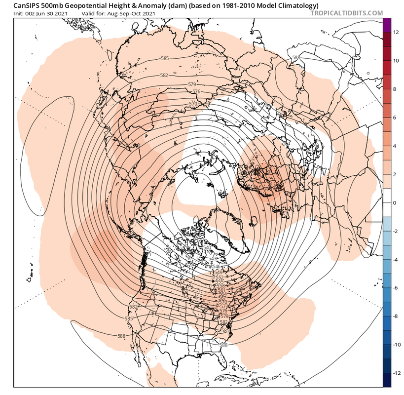
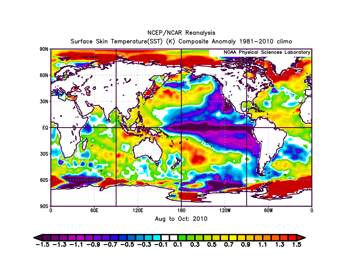
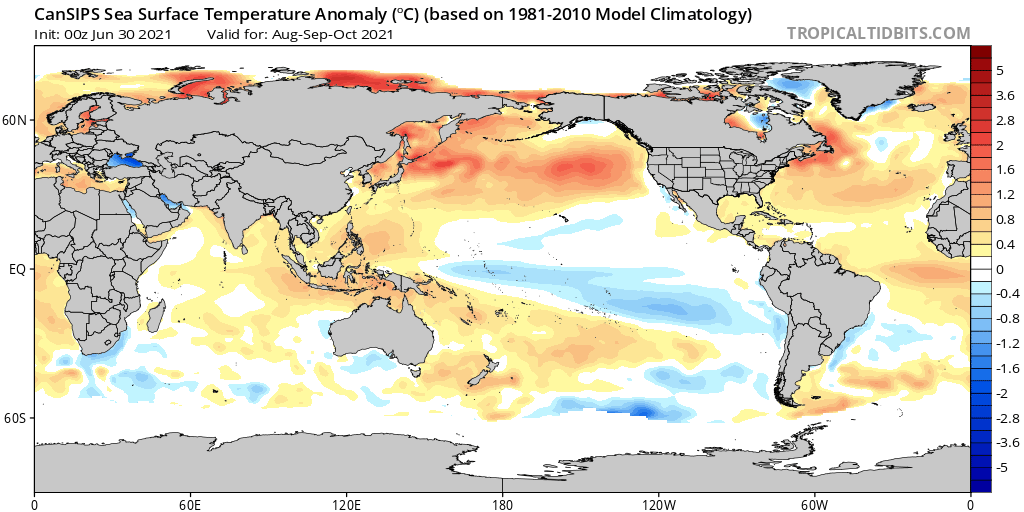
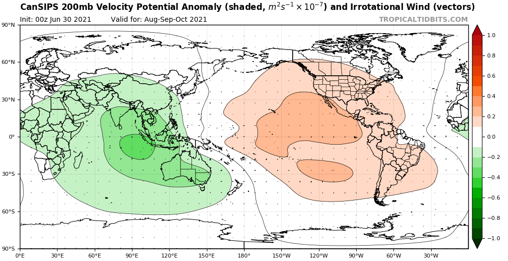
Here is what can be expected for the 2021 Atlantic Hurricane Season based on climate models:
Based on what is listed here, the best analogs for 2021 are 2020, 2010, and 2004. 2020, 2010, and 2004 had +TNA and a strong WAM; 2020 and 2010 had La Niña; 2010 and 2004 had Atlantic Niño; 2020 had -VP over EPAC; 2010 had -PDO; and 2004 had a strong SE Canada Ridge. 2020 is the best analog for 2021 in terms of VP anomalies; 2010 is the best analog for 2021 in terms of SST anomalies; 2004 is the best analog for 2021 in terms of height anomalies.
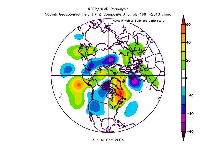
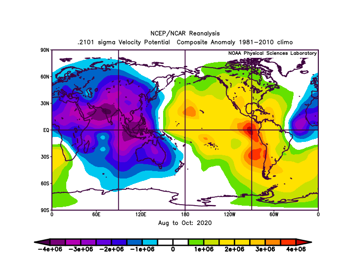
2010 had anomalously dry air in the Atlantic. Assuming that does not happen in 2021, there could be just as many storms as there were in 2020 that form in conditions even more favorable than those last year. In a typical year, 50% of the storms make it to hurricane status, and 25% of the storms make it to major hurricane status. Last year, 46.6% of the storms made it to hurricane status, and 23.3% of the storms made it to major hurricane status. In 2010, 63.15% of the storms made it to hurricane status, and 26.31% of the storms made it to major hurricane status. If the 2010 ratios are kept, that could mean a season with 30 storms, 19 hurricanes, and 8 major hurricanes.
People who live in the Southern United States or the Antilles should be very prepared this hurricane season. Hurricanes Charley, Frances, and Jeanne brought major impacts to Florida. Hurricane Gaston made landfall in the Carolinas as hurricane, and it caused hundreds of millions in damages. Hurricane Ivan brought devastating impacts to the Gulf Coast. These storms also wrecked the Bahamas and the Antilles. Should this forecast come true, it would mean even more impacts for those who live in areas affected by the 2004 Atlantic Hurricane Season.
Takeaways:
- +TNA

- Strong WAM
- -VP over EPAC
- La Niña
- -PDO
- Atlantic Niño
- Strong SE Canada Ridge (W)
Based on what is listed here, the best analogs for 2021 are 2020, 2010, and 2004. 2020, 2010, and 2004 had +TNA and a strong WAM; 2020 and 2010 had La Niña; 2010 and 2004 had Atlantic Niño; 2020 had -VP over EPAC; 2010 had -PDO; and 2004 had a strong SE Canada Ridge. 2020 is the best analog for 2021 in terms of VP anomalies; 2010 is the best analog for 2021 in terms of SST anomalies; 2004 is the best analog for 2021 in terms of height anomalies.
2010 had anomalously dry air in the Atlantic. Assuming that does not happen in 2021, there could be just as many storms as there were in 2020 that form in conditions even more favorable than those last year. In a typical year, 50% of the storms make it to hurricane status, and 25% of the storms make it to major hurricane status. Last year, 46.6% of the storms made it to hurricane status, and 23.3% of the storms made it to major hurricane status. In 2010, 63.15% of the storms made it to hurricane status, and 26.31% of the storms made it to major hurricane status. If the 2010 ratios are kept, that could mean a season with 30 storms, 19 hurricanes, and 8 major hurricanes.
People who live in the Southern United States or the Antilles should be very prepared this hurricane season. Hurricanes Charley, Frances, and Jeanne brought major impacts to Florida. Hurricane Gaston made landfall in the Carolinas as hurricane, and it caused hundreds of millions in damages. Hurricane Ivan brought devastating impacts to the Gulf Coast. These storms also wrecked the Bahamas and the Antilles. Should this forecast come true, it would mean even more impacts for those who live in areas affected by the 2004 Atlantic Hurricane Season.
Takeaways:
- The 2021 Atlantic Hurricane Season is likely to be very active, and there is a significant possibility it might match the previous hurricane season in terms of activity.
- This hurricane season will most likely affect the Southern United States, the Bahamas, and the Antilles.
Last edited by AlphaToOmega on Sat Jul 17, 2021 2:01 pm, edited 2 times in total.
7 likes
-
Category5Kaiju
- Category 5
- Posts: 4334
- Joined: Thu Dec 24, 2020 12:45 pm
- Location: Seattle and Phoenix
Re: 2021 Indicators: SST's / SAL / MSLP / Shear / Steering / Instability / Sat Images
I would be interested to see if this season (assuming it indeed becomes very active) ends up as being a "burst" type of season (kind of like 2004, 2010, or 2017) with the most intense and dangerous activity concentrated in a month or two's span of time or if it ends up more as a "slow-burn" type of season (kind of like 1995, 2005, or 2020) with the most intense and dangerous activity spread out over three months or more.
6 likes
Unless explicitly stated, all info in my posts is based on my own opinions and observations. Tropical storms and hurricanes can be extremely dangerous. Refer to an accredited weather research agency or meteorologist if you need to make serious decisions regarding an approaching storm.
-
AlphaToOmega
- Category 5
- Posts: 1448
- Joined: Sat Jun 26, 2021 10:51 am
- Location: Somewhere in Massachusetts
Re: 2021 Indicators: SST's / SAL / MSLP / Shear / Steering / Instability / Sat Images
Category5Kaiju wrote:I would be interested to see if this season (assuming it indeed becomes very active) ends up as being a "burst" type of season (kind of like 2004, 2010, or 2017) with the most intense and dangerous activity concentrated in a month or two's span of time or if it ends up more as a "slow-burn" type of season (kind of like 1995, 2005, or 2020) with the most intense and dangerous activity spread out over three months or more.
2021 will likely be a "slow burn" season. The VP anomalies almost exactly match those in 2020. The only reason 2010 was not a "slow burn" season was because of the massive amount of dry air. If that were not there, there might have been major hurricanes in October and even November of that year.
1 likes
-
USTropics
- Professional-Met
- Posts: 2739
- Joined: Sun Aug 12, 2007 3:45 am
- Location: Florida State University
Re: 2021 Indicators: SST's / SAL / MSLP / Shear / Steering / Instability / Sat Images
NDG wrote:I believe CDAS daily SSTs charts have a cooler bias over the MDR when dust is present over it, looking at the two images they both match pretty good in all areas except over the MDR.
https://i.imgur.com/rIfm2zU.png
https://i.imgur.com/XnETZPA.png
That is correct. To be more specific, CDAS relies more on satellite derived data input compared to NOAA's Coral Reef Watch products or OISST products. CDAS uses the following satellite spectrums for color:
- 6.925, 10.65 GHz Brightness Temperature (V/H Polarization)
- 23.8, 36.5 GHz Brightness Temperature (H Polarization)
The CDAS documentation states that when data is contaminated by convection/SAL outbreaks (i.e., color spectrum becomes opaque), a formula is implemented that essentially counts the number of pixels within 6 GHz or 10 GHz spatial resolution. We can see from CIMSS SAL products, this has caused an issue with the CDAS data input:

5 likes

Re: 2021 Indicators: SST's / SAL / MSLP / Shear / Steering / Instability / Sat Images
Yellow Evan wrote:It is plausible that the summer WAM is causing the summer reversals of AMO and preventing us from a true -AMO phase. Whether this is a sign of a true -AMO pattern down the line or a replacement of a true -AMO phase altogether are up for debate.
If the WAM (or other factors like climate change) are masking us actually now being in a -AMO, it's quite scary what we might see in 15 years when the +AMO phase returns.
1 likes
Who is online
Users browsing this forum: MarioProtVI, Ulf and 270 guests