2023 Global Model Runs Discussion (Out thru day 16)
Moderator: S2k Moderators
Forum rules
The posts in this forum are NOT official forecasts and should not be used as such. They are just the opinion of the poster and may or may not be backed by sound meteorological data. They are NOT endorsed by any professional institution or STORM2K. For official information, please refer to products from the National Hurricane Center and National Weather Service.
- Iceresistance
- Category 5

- Posts: 9607
- Age: 22
- Joined: Sat Oct 10, 2020 9:45 am
- Location: Tecumseh, OK/Norman, OK
Re: 2023 Global Model Runs Discussion (Out thru day 16)
Idalia looks to be a factor on the future outcome of these TWs from Africa.
That 960mb run from the Euro is very unusual and concerning.
That 960mb run from the Euro is very unusual and concerning.
2 likes
Bill 2015 & Beta 2020
Winter 2020-2021
All observations are in Tecumseh, OK unless otherwise noted.
Winter posts are focused mainly for Oklahoma & Texas.
Take any of my forecasts with a grain of salt, refer to the NWS, SPC, and NHC for official information
Never say Never with weather! Because ANYTHING is possible!
Winter 2020-2021

All observations are in Tecumseh, OK unless otherwise noted.
Winter posts are focused mainly for Oklahoma & Texas.
Take any of my forecasts with a grain of salt, refer to the NWS, SPC, and NHC for official information
Never say Never with weather! Because ANYTHING is possible!
- weeniepatrol
- Category 5

- Posts: 1345
- Joined: Sat Aug 22, 2020 5:30 pm
- Location: WA State
Re: 2023 Global Model Runs Discussion (Out thru day 16)
jlauderdal wrote:SFLcane wrote:https://i.postimg.cc/GhPT5zrt/jjjjjnnn.gif
Looks like peak hurricane season...when do the fish posts start on this one?
AutoPenalti wrote:EPS looks fishy.
Certified S2k moment
8 likes
- Hypercane_Kyle
- Category 5

- Posts: 3465
- Joined: Sat Mar 07, 2015 7:58 pm
- Location: Cape Canaveral, FL
Re: 2023 Global Model Runs Discussion (Out thru day 16)
This storm's track looks like it'll be heavily dependent on whatever future Idalia has. If Idalia's still hanging around by Bermuda, the window for recurvature is greater.
0 likes
My posts are my own personal opinion, defer to the National Hurricane Center (NHC) and other NOAA products for decision making during hurricane season.
-
AutoPenalti
- Category 5

- Posts: 4091
- Age: 29
- Joined: Mon Aug 17, 2015 4:16 pm
- Location: Ft. Lauderdale, Florida
Re: 2023 Global Model Runs Discussion (Out thru day 16)
weeniepatrol wrote:jlauderdal wrote:SFLcane wrote:https://i.postimg.cc/GhPT5zrt/jjjjjnnn.gif
Looks like peak hurricane season...when do the fish posts start on this one?AutoPenalti wrote:EPS looks fishy.
Certified S2k moment
I had too
1 likes
The posts in this forum are NOT official forecasts and should not be used as such. They are just the opinion of the poster and may or may not be backed by sound meteorological data. They are NOT endorsed by any professional institution or STORM2K. For official information, please refer to products from the NHC and NWS.
Model Runs Cheat Sheet:
GFS (5:30 AM/PM, 11:30 AM/PM)
HWRF, GFDL, UKMET, NAVGEM (6:30-8:00 AM/PM, 12:30-2:00 AM/PM)
ECMWF (1:45 AM/PM)
TCVN is a weighted averaged
Re: 2023 Global Model Runs Discussion (Out thru day 16)
Iceresistance wrote:Idalia looks to be a factor on the future outcome of these TWs from Africa.
That 960mb run from the Euro is very unusual and concerning.
So either we want idalia possibly coming back this way, or the new, more powerful system.
0 likes
Re: 2023 Global Model Runs Discussion (Out thru day 16)
Ianswfl wrote:Iceresistance wrote:Idalia looks to be a factor on the future outcome of these TWs from Africa.
That 960mb run from the Euro is very unusual and concerning.
So either we want idalia possibly coming back this way, or the new, more powerful system.
We need something in Texas. Florida has had enough rain. Currently in a D3 extreme drought here.
1 likes
Re: 2023 Global Model Runs Discussion (Out thru day 16)
Ianswfl wrote:Iceresistance wrote:Idalia looks to be a factor on the future outcome of these TWs from Africa.
That 960mb run from the Euro is very unusual and concerning.
So either we want idalia possibly coming back this way, or the new, more powerful system.
Idk why you want another storm to come to SWFL after what Ian did last year.
3 likes
Re: 2023 Global Model Runs Discussion (Out thru day 16)
AutoPenalti wrote:EPS looks fishy.
yup, that weakness isn't going anywhere, looks up and out for now....
0 likes
Re: 2023 Global Model Runs Discussion (Out thru day 16)
Maybe we should wait until something actually develops until we declare a “fish” storm. Lesser Antilles and PR might be threatened by this wave.
13 likes
-
emeraldislenc
- Category 2

- Posts: 602
- Joined: Fri Aug 24, 2012 4:49 pm
- Location: Emerald Isle NC
Re: 2023 Global Model Runs Discussion (Out thru day 16)
I agree nothing has formed some are already say fish!
2 likes
-
Stratton23
- Category 5

- Posts: 3575
- Joined: Fri Jul 21, 2023 10:59 pm
- Location: Katy, Tx
Re: 2023 Global Model Runs Discussion (Out thru day 16)
Declaring a fish storm before something has even developed yet is extremely ignorant, lets wait and see if something develops first
7 likes
- Category5Kaiju
- Category 5

- Posts: 4346
- Joined: Thu Dec 24, 2020 12:45 pm
- Location: Seattle during the summer, Phoenix during the winter
Re: 2023 Global Model Runs Discussion (Out thru day 16)
Stratton23 wrote:Declaring a fish storm before something has even developed yet is extremely ignorant, lets wait and see if something develops first
Ever since Irma and Florence, I typically refrain myself from declaring "fish" until the storm actually forms and we get a better idea on steering patterns.
One thing we do know; considering Idalia is expected to take this weird SE dive after exiting the Eastern Seaboard, the ridging (at least in the near future) may not be that wimpy.
6 likes
Unless explicitly stated, all information in my posts is based on my own opinions and observations. Tropical storms and hurricanes can be extremely dangerous. Refer to an accredited weather research agency or meteorologist if you need to make serious decisions regarding an approaching storm.
- Blown Away
- S2K Supporter

- Posts: 10253
- Joined: Wed May 26, 2004 6:17 am
Re: 2023 Global Model Runs Discussion (Out thru day 16)
Stratton23 wrote:Declaring a fish storm before something has even developed yet is extremely ignorant, lets wait and see if something develops first
Models continue showing TW’s coming off Africa pretty high @15 degrees and many of those will recurve OTS with Bermuda being a potential target.
0 likes
Hurricane Eye Experience: David 79, Irene 99, Frances 04, Jeanne 04, Wilma 05… Hurricane Brush Experience: Andrew 92, Erin 95, Floyd 99, Matthew 16, Irma 17, Ian 22, Nicole 22…
Re: 2023 Global Model Runs Discussion (Out thru day 16)
Blown Away wrote:Stratton23 wrote:Declaring a fish storm before something has even developed yet is extremely ignorant, lets wait and see if something develops first
Models continue showing TW’s coming off Africa pretty high @15 degrees and many of those will recurve OTS with Bermuda being a potential target.
The TW coming off of Africa on Saturday will be a pretty low latitude might have a decent chance of making it to the islands.
9 likes
Re: 2023 Global Model Runs Discussion (Out thru day 16)
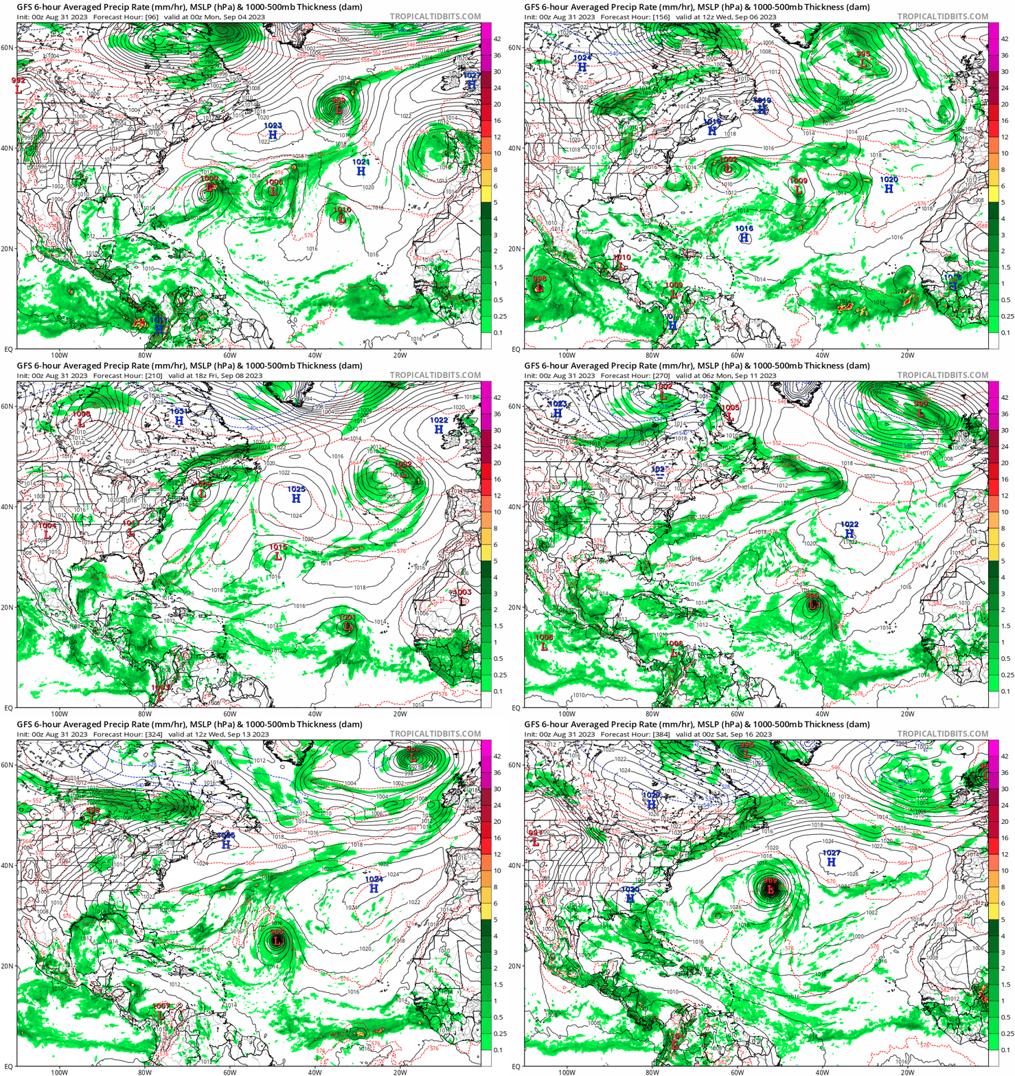
0z GFS now on board


0 likes
TC naming lists: retirements and intensity
Most aggressive Advisory #1's in North Atlantic (cr. kevin for starting the list)
Most aggressive Advisory #1's in North Atlantic (cr. kevin for starting the list)
Re: 2023 Global Model Runs Discussion (Out thru day 16)
Teban54 wrote:0z GFS now on board
https://i.postimg.cc/N0gzqz8F/gfs-mslp-pcpn-atl-fh96-384.gif
I think that might be the 2nd wave that the 12Z Euro has developing. Looks like the GFS doesn’t do anything with the 1st wave but I could be wrong.
1 likes
Re: 2023 Global Model Runs Discussion (Out thru day 16)
whatever forms looks to recurve safely out to sea.....
0 likes
Re: 2023 Global Model Runs Discussion (Out thru day 16)
Eure ensembles members some have shifted pretty far south compared to 12z. A lot of strong members too.
0 likes
- Iceresistance
- Category 5

- Posts: 9607
- Age: 22
- Joined: Sat Oct 10, 2020 9:45 am
- Location: Tecumseh, OK/Norman, OK
Re: 2023 Global Model Runs Discussion (Out thru day 16)
0 likes
Bill 2015 & Beta 2020
Winter 2020-2021
All observations are in Tecumseh, OK unless otherwise noted.
Winter posts are focused mainly for Oklahoma & Texas.
Take any of my forecasts with a grain of salt, refer to the NWS, SPC, and NHC for official information
Never say Never with weather! Because ANYTHING is possible!
Winter 2020-2021

All observations are in Tecumseh, OK unless otherwise noted.
Winter posts are focused mainly for Oklahoma & Texas.
Take any of my forecasts with a grain of salt, refer to the NWS, SPC, and NHC for official information
Never say Never with weather! Because ANYTHING is possible!
Who is online
Users browsing this forum: Hurricane2022, ljmac75 and 139 guests


