Honeyko wrote:Mecklenburg wrote:(Re: Allison)...but not as a TS, but a TD... after all, it was only tropical for a very short as most of the time it was subtropical...

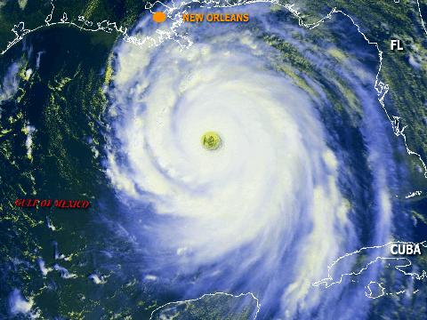
Allison was a thoroughly tropical (not subtropical) warm-core
system over land for mostof that trip across the US of A. Friction may have kept her surface winds down to squat, but she remained organized upstairs. (Storms over flat terrain will do that in August; all they need is one good feeder still half hanging in the ocean, and they keep chuggin' along.)
Care to check your facts?
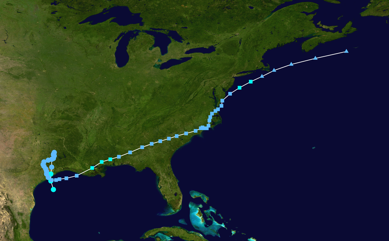
05 / 1200 27.5 95.0 1007 40 tropical storm
05 / 1800 28.5 95.3 1002 50 "
06 / 0000 29.3 95.3 1003 45 "
06 / 0600 30.1 95.2 1006 30 tropical depression
06 / 1200 31.0 95.2 1005 20 "
06 / 1800 31.5 95.0 1005 20 "
07 / 0000 31.6 95.0 1005 20 "
07 / 0600 31.8 94.9 1006 20 "
07 / 1200 31.4 94.9 1006 20 "
07 / 1800 31.1 95.0 1007 15 "
08 / 0000 30.9 95.6 1002 15 "
08 / 0600 30.7 96.1 1004 20 "
08 / 1200 30.4 96.2 1007 20 "
08 / 1800 30.2 96.1 1007 20 "
09 / 0000 29.9 95.9 1007 20 "
09 / 0600 29.6 95.8 1007 20 "
09 / 1200 29.3 95.8 1007 20 "
09 / 1800 28.9 95.6 1008 20 "
10 / 0000 28.6 95.2 1008 20 subtropical depression
10 / 0600 28.6 94.7 1007 25 "
10 / 1200 28.7 94.3 1006 25 "
10 / 1800 28.8 93.5 1006 30 "
11 / 0000 29.1 92.3 1005 30 subtropical depression (New center)
11 / 0600 30.0 90.5 1003 35 subtropical storm
11 / 1200 30.7 89.4 1000 40 "
11 / 1800 31.0 88.4 1002 35 "
12 / 0000 31.3 87.4 1004 25 subtropical depression
12 / 0600 31.8 86.1 1005 20 "
12 / 1200 32.4 84.7 1006 20 "
12 / 1800 32.8 83.6 1006 20 "
13 / 0000 33.1 82.6 1006 20 "
13 / 0600 33.4 81.6 1004 25 "
13 / 1200 33.7 80.7 1005 25 "
13 / 1800 34.0 79.6 1006 25 "
14 / 0000 34.3 78.5 1006 25 "
14 / 0600 34.6 77.9 1006 25 "
14 / 1200 34.7 77.7 1007 25 "
14 / 1800 34.6 77.6 1008 25 "
15 / 0000 34.6 77.2 1008 25 "
15 / 0600 34.9 77.0 1008 25 "
15 / 1200 35.5 76.9 1008 25 "
15 / 1800 35.9 76.8 1009 25 "
16 / 0000 36.3 76.6 1007 25 "
16 / 0600 36.6 76.2 1007 25 "
16 / 1200 36.8 75.9 1007 25 "
16 / 1800 37.2 75.5 1006 25 "
17 / 0000 37.8 75.4 1006 25 "
17 / 0600 38.6 74.5 1005 30 "
17 / 1200 39.3 73.4 1004 40 subtropical storm
17 / 1800 40.0 72.1 1005 35 "
18 / 0000 40.6 70.8 1006 30 extratropical low
18 / 0600 41.3 69.4 1008 30 "
18 / 1200 42.0 67.4 1009 30 "
18 / 1800 42.7 64.6 1011 25 "
19 / 0000 43.5 61.0 1012 20 "
19 / 0600 dissipated