MJO

This is the general tropical discussion area. Anyone can take their shot at predicting a storms path.

Moderator: S2k Moderators

Forum rules

The posts in this forum are NOT official forecasts and should not be used as such. They are just the opinion of the poster and may or may not be backed by sound meteorological data. They are NOT endorsed by any professional institution or STORM2K. For official information, please refer to products from the National Hurricane Center and National Weather Service.

Help Support Storm2K
Message
Author
User avatar
wxwatcher91
Category 5
Category 5
Posts: 1606
Joined: Wed Jul 06, 2005 2:43 pm
Location: Keene, NH
Contact:

#141 Postby wxwatcher91 » Wed Aug 10, 2005 8:40 pm

Tampa Bay Hurricane wrote:Ladies and Gentlemen, Boys and Girls...hop on board the Active train and get rrready for a wild ride!!


I dont doubt that this statement is correct... however just to note that this statement has been made about 20 times in the past month by various people and we have gotten nothing... lets hope this time the statement is correct... I support you 100% Tampa Bay Hurricane :D
0 likes   

User avatar
boca
Category 5
Category 5
Posts: 6367
Age: 60
Joined: Mon Dec 15, 2003 8:49 am
Location: Boca Raton,FL

#142 Postby boca » Wed Aug 10, 2005 11:06 pm

Tampa Bay Hurricane I guess your a Bush Gardens rollercoaster type of person I like that wild ride phrase.
0 likes   

User avatar
Tampa Bay Hurricane
Category 5
Category 5
Posts: 5597
Age: 37
Joined: Fri Jul 22, 2005 7:54 pm
Location: St. Petersburg, FL

#143 Postby Tampa Bay Hurricane » Thu Aug 11, 2005 7:25 pm

Watch but hope none hit land so nobody gets hurt...

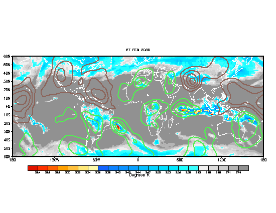
MJO is getting more favorable BTW it's gonna get REEAAALLL CRAZY!!!

Epitome of chronic insanity will be the Atlantic

MJO very Favorable over Cape Verde Waves
Image


YEEEE HAWWW!!!
0 likes   

User avatar
TampaFl
S2K Supporter
S2K Supporter
Posts: 1904
Age: 67
Joined: Thu Sep 04, 2003 11:23 am
Location: Tampa, FL

#144 Postby TampaFl » Sun Aug 14, 2005 4:59 am

Current status of MJO

BUMP

Robert 8-)
0 likes   

Scorpion

#145 Postby Scorpion » Sun Aug 14, 2005 7:42 am

Apparently the MJO doesn't really matter as TD 10 is almost dead anyways.
0 likes   

Jim Hughes
Category 3
Category 3
Posts: 825
Joined: Sun Jul 24, 2005 1:52 pm
Location: Martinsburg West Virginia

#146 Postby Jim Hughes » Sun Aug 14, 2005 8:13 am

Scorpion wrote:Apparently the MJO doesn't really matter as TD 10 is almost dead anyways.


It is just one or many. Like I mentioned in a thread about a week ago or more. MJO was the catch phrase of the month. Maybe people should start considering what other variables are effecting the season.


Jim
0 likes   

User avatar
AussieMark
Category 5
Category 5
Posts: 5858
Joined: Tue Sep 02, 2003 6:36 pm
Location: near Sydney, Australia

#147 Postby AussieMark » Sun Aug 14, 2005 8:29 am

0 likes   

User avatar
cycloneye
Admin
Admin
Posts: 145276
Age: 68
Joined: Thu Oct 10, 2002 10:54 am
Location: San Juan, Puerto Rico

#148 Postby cycloneye » Sun Aug 14, 2005 8:32 am


Dry MJO,Negative NAO.
0 likes   
Visit the Caribbean-Central America Weather Thread where you can find at first post web cams,radars
and observations from Caribbean basin members Click Here

LarryWx
S2K Supporter
S2K Supporter
Posts: 6300
Joined: Sun Sep 07, 2003 2:04 pm
Location: GA

#149 Postby LarryWx » Sun Aug 14, 2005 8:36 am

I recall the MJO NOT being a reliable indicator at all last year.
Of course, last year not being reliable could have been an "outlier" of sorts. Nevertheless, in my opinion, it is unproven statistically. I'd love to see a hard statistical study on MJO. I'm betting that one of the problems is that classifying wet or dry is subjective/inexact, sort of like the qualifications for a negative NAO.
Last edited by LarryWx on Sun Aug 14, 2005 9:12 am, edited 1 time in total.
0 likes   
Personal Forecast Disclaimer:
The posts in this forum are NOT official forecasts and should not be used as such. They are just the opinion of the poster and may or may not be backed by sound meteorological data. They are NOT endorsed by any professional institution or storm2k.org. For official information, please refer to the NHC and NWS products.

Jim Hughes
Category 3
Category 3
Posts: 825
Joined: Sun Jul 24, 2005 1:52 pm
Location: Martinsburg West Virginia

#150 Postby Jim Hughes » Sun Aug 14, 2005 9:10 am

cycloneye wrote:


Dry MJO,Negative NAO.


I couldn't argue with your line of reasoning. Now what caused these unfavorable changes ?

I posted a research paper a while ago dealing with the influence of the solar wind electric field modulation of the NAO. By Boberg and Lundstedt.

All tropical systems this year have reacted to space weather changes but everyone seems to be avoiding this possible influence.

I started a post in the Talkin Tropics Forum, of a make believe horse race , regarding a match race between 2004 & 2005 and it gets 300 plus views within two hours but over in the Global Forum my posts get 20-30 views in three days time.

Where's the logic for me posting an extensive in depth correlation analysis over there? It's a waste of my time...In the mean time this forum loses a great opportunity to learn about an important factor in climate-atmospheric dynamics.


Jim
0 likes   

User avatar
cycloneye
Admin
Admin
Posts: 145276
Age: 68
Joined: Thu Oct 10, 2002 10:54 am
Location: San Juan, Puerto Rico

#151 Postby cycloneye » Mon Aug 15, 2005 12:30 pm

Image

Still the Atlantic is not very favorable as the wet MJO has not completly invaded the basin.It is a matter of time when the favorable MJO will be completly in the Atlantic.
0 likes   
Visit the Caribbean-Central America Weather Thread where you can find at first post web cams,radars
and observations from Caribbean basin members Click Here

Frank2
Category 5
Category 5
Posts: 4061
Joined: Mon Jul 25, 2005 12:47 pm

#152 Postby Frank2 » Mon Aug 15, 2005 1:04 pm

Some interesting comments here - I agree that the tropics are much more complicated than just one or even two positive or negative factors, though at this time, the factors against development are still winning (not counting Irene).

Frank
0 likes   

User avatar
johngaltfla
Category 5
Category 5
Posts: 2069
Joined: Sun Jul 10, 2005 9:17 pm
Location: Sarasota County, FL
Contact:

#153 Postby johngaltfla » Mon Aug 15, 2005 7:02 pm

cycloneye wrote:Image

Still the Atlantic is not very favorable as the wet MJO has not completly invaded the basin.It is a matter of time when the favorable MJO will be completly in the Atlantic.


Ugh. 7-10 days I'll bet.

Right for a month of fun, games and no sleep.

I just don't want to go through a night of my neighbors crap that they didn't batten down bouncing off my house ever again. I can see where this is heading. Perfect water temps, excellent MJO coverage, and a parade of systems hitting 85-90 degree water for a month solid. Just my speculation, but I don't think it's too far from reality. :eek:
0 likes   

User avatar
TampaFl
S2K Supporter
S2K Supporter
Posts: 1904
Age: 67
Joined: Thu Sep 04, 2003 11:23 am
Location: Tampa, FL

#154 Postby TampaFl » Wed Aug 17, 2005 8:25 am

Current status of MJO. Look out, the tropics are ready to get very active over the next couple of weeks.

BUMP

Robert 8-)
0 likes   

User avatar
weatherwoman
Category 1
Category 1
Posts: 364
Joined: Sun Sep 05, 2004 9:09 pm
Location: Newport North Carolina
Contact:

#155 Postby weatherwoman » Wed Aug 17, 2005 10:04 am

good day to everyone
0 likes   

User avatar
wxmann_91
Category 5
Category 5
Posts: 8013
Age: 34
Joined: Fri Jul 15, 2005 2:49 pm
Location: Southern California
Contact:

#156 Postby wxmann_91 » Wed Aug 17, 2005 10:48 am

Well, with all the dry air around, it is good to assume that even if the wet MJO gets here we will have to wait a week for the wetness to completely douse Sal. And it is also interesting to see the thickness of the wet MJO, looks like once the eastern edge gets to the CV islands the western edge is already to the North American continent, and the dry MJO won't be far behind. So it probably won't be as active as everybody thinks. Just an observation here.
0 likes   

User avatar
johngaltfla
Category 5
Category 5
Posts: 2069
Joined: Sun Jul 10, 2005 9:17 pm
Location: Sarasota County, FL
Contact:

#157 Postby johngaltfla » Wed Aug 17, 2005 6:00 pm

I think we're about to see the beginning of the wild season...that map today is disturbing a it fills out over the Atlantic..
0 likes   

User avatar
TampaFl
S2K Supporter
S2K Supporter
Posts: 1904
Age: 67
Joined: Thu Sep 04, 2003 11:23 am
Location: Tampa, FL

#158 Postby TampaFl » Thu Aug 18, 2005 3:48 am

BUMP
0 likes   

User avatar
cycloneye
Admin
Admin
Posts: 145276
Age: 68
Joined: Thu Oct 10, 2002 10:54 am
Location: San Juan, Puerto Rico

#159 Postby cycloneye » Thu Aug 18, 2005 10:56 am

More and more the Atlantic is turning more favorable as the wet phase of MJO arrives at the basin.But it is a slow proccess that goes on with this so it may not be entirely favorable as of yet.But in the next few weeks when the peak of the season arrives especially the second week of september it will be favorable for cyclogeneris.However other factors may cancel this MJO favorable such as an unexpected weak el nino,NAO staying negative and SOI tanking.Let's watch all of these factors and see if they will coincide with MJO being favorable making the rest of the season very active or on the contrary the rest of the season will be under what the experts (Dr Gray,NOAA and Tropical Storm Risk) predicted in their August outlooks.
0 likes   
Visit the Caribbean-Central America Weather Thread where you can find at first post web cams,radars
and observations from Caribbean basin members Click Here

User avatar
TampaFl
S2K Supporter
S2K Supporter
Posts: 1904
Age: 67
Joined: Thu Sep 04, 2003 11:23 am
Location: Tampa, FL

#160 Postby TampaFl » Fri Aug 19, 2005 9:20 am

Bump
0 likes   


Return to “Talkin' Tropics”

Who is online

Users browsing this forum: No registered users and 40 guests