2020 Global Model Runs Discussion (Out thru day 16)
Moderator: S2k Moderators
Forum rules

The posts in this forum are NOT official forecasts and should not be used as such. They are just the opinion of the poster and may or may not be backed by sound meteorological data. They are NOT endorsed by any professional institution or STORM2K. For official information, please refer to products from the National Hurricane Center and National Weather Service.

Re: 2020 Global Model Runs Discussion (Out thru day 16)
The 00z Euro has a strong wave in the Gulf at day 10.
0 likes

Re: 2020 Global Model Runs Discussion (Out thru day 16)

It's here
7 likes
Kendall -> SLO -> PBC
Memorable Storms: Katrina (for its Florida landfall...) Wilma Matthew Irma
Memorable Storms: Katrina (for its Florida landfall...) Wilma Matthew Irma
-
DorkyMcDorkface

- Category 5

- Posts: 1042
- Age: 28
- Joined: Mon Sep 30, 2019 1:32 pm
- Location: Mid-Atlantic
Re: 2020 Global Model Runs Discussion (Out thru day 16)


10 likes
Please note the thoughts expressed by this account are solely those of the user and are from a hobbyist perspective. For more comprehensive analysis, consult an actual professional meteorologist or meteorological agency.
Floyd 1999 | Isabel 2003 | Hanna 2008 | Irene 2011 | Sandy 2012 | Isaias 2020
-
crownweather

- S2K Supporter

- Posts: 602
- Age: 51
- Joined: Sat Aug 12, 2006 9:21 am
- Location: Sturbridge, Massachusetts
- Contact:
Re: 2020 Global Model Runs Discussion (Out thru day 16)
0 likes
Rob Lightbown
Crown Weather Services
https://crownweather.com
Crown Weather Services
https://crownweather.com
Re: 2020 Global Model Runs Discussion (Out thru day 16)
Man, that takes a cane right over my house here in southeast Texas.
0 likes
-
Kingarabian

- S2K Supporter
- Posts: 16379
- Joined: Sat Aug 08, 2009 3:06 am
- Location: Honolulu, Hawaii
Re: 2020 Global Model Runs Discussion (Out thru day 16)
Operational Euro takes has a track over land.

can easily change
can easily change
0 likes
RIP Kobe Bryant

Re: 2020 Global Model Runs Discussion (Out thru day 16)
The wave currently at 45W is the one that will possibly spin up in the Carib and enter the GoM next Sunday.
Some low latitude convection currently firing there.
Looks like it is trying to break away from the ITCZ.
Some low latitude convection currently firing there.
Looks like it is trying to break away from the ITCZ.
2 likes

Re: 2020 Global Model Runs Discussion (Out thru day 16)
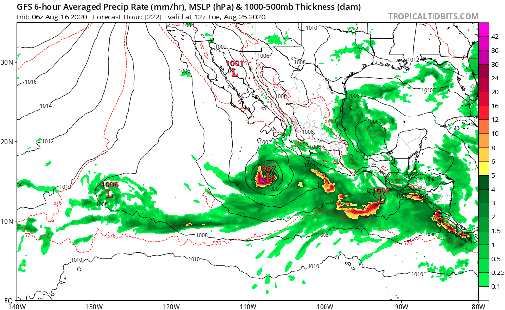
GFS 06z - not much there. It’s got a little spin up right off the Yucatán. But that’s it.
https://www.tropicaltidbits.com/analysi ... 81606&fh=6
https://www.tropicaltidbits.com/analysi ... 81606&fh=6
0 likes
-
gatorcane

- S2K Supporter
- Posts: 23708
- Age: 48
- Joined: Sun Mar 13, 2005 3:54 pm
- Location: Boca Raton, FL
Re: 2020 Global Model Runs Discussion (Out thru day 16)
Steve wrote:GFS 06z - not much there. It’s got a little spin up right off the Yucatán. But that’s it.
https://www.tropicaltidbits.com/analysi ... 81606&fh=6
That’s because it continues keeping the EPAC active with the monsoon trough over the region and into Central America. As some of mentioned it is likely wrong with the MJO but timeframe on these storms is coming in.
3 likes

Re: 2020 Global Model Runs Discussion (Out thru day 16)
The trend by the Euro ensembles, not good.

9 likes
Re: 2020 Global Model Runs Discussion (Out thru day 16)
That’s right. It has continuously backed away from more potent EPAC storms. And it has gradually adjusted its 2 week MJO forecast and is closer to aligning with reality. But it has overall not been very good with recognition (localized and large scale) and therefore hasn’t been particularly useful in recognizing upcoming threats before even some of the JV models.
2 likes
Re: 2020 Global Model Runs Discussion (Out thru day 16)
Don't look for any OTS storms that form during the next 4-10 days with a strong Bermuda ridge developing as forecasted by the ensemble models.


2 likes
-
1900hurricane

- Category 5
- Posts: 6063
- Age: 34
- Joined: Fri Feb 06, 2015 12:04 pm
- Location: Houston, TX
- Contact:
Re: 2020 Global Model Runs Discussion (Out thru day 16)
As guidance continues to get a better grasp on Madden-Julian, I am fully expecting the uptick in impactful solutions to continue.
4 likes
Contract Meteorologist. TAMU & MSST. Fiercely authentic, one of a kind. We are all given free will, so choose a life meant to be lived. We are the Masters of our own Stories.
Opinions expressed are mine alone.
Follow me on Twitter at @1900hurricane : Read blogs at https://1900hurricane.wordpress.com/
Opinions expressed are mine alone.
Follow me on Twitter at @1900hurricane : Read blogs at https://1900hurricane.wordpress.com/

Re: 2020 Global Model Runs Discussion (Out thru day 16)
I wake up, look at this thread, and find that the ensembles have gone nuclear with a ton of members showing at least a Cat 1-2 near the Greater Antilles and/or heading into the Gulf within the next 10 days, and the second AEW has also been marked by the NHC. The big burst in activity we’ve been anticipating is almost here.
3 likes
Irene '11 Sandy '12 Hermine '16 5/15/2018 Derecho Fay '20 Isaias '20 Elsa '21 Henri '21 Ida '21
I am only a meteorology enthusiast who knows a decent amount about tropical cyclones. Look to the professional mets, the NHC, or your local weather office for the best information.
I am only a meteorology enthusiast who knows a decent amount about tropical cyclones. Look to the professional mets, the NHC, or your local weather office for the best information.
-
northjaxpro

- S2K Supporter
- Posts: 8900
- Joined: Mon Sep 27, 2010 11:21 am
- Location: Jacksonville, FL
Re: 2020 Global Model Runs Discussion (Out thru day 16)
aspen wrote:I wake up, look at this thread, and find that the ensembles have gone nuclear with a ton of members showing at least a Cat 1-2 near the Greater Antilles and/or heading into the Gulf within the next 10 days, and the second AEW has also been marked by the NHC. The big burst in activity we’ve been anticipating is almost here.
Yes, it is only beginning. We haven't seen nothing yet.
0 likes
NEVER, EVER SAY NEVER in the tropics and weather in general, and most importantly, with life itself!!
________________________________________________________________________________________
Fay 2008 Beryl 2012 Debby 2012 Colin 2016 Hermine 2016 Julia 2016 Matthew 2016 Irma 2017 Dorian 2019
________________________________________________________________________________________
Fay 2008 Beryl 2012 Debby 2012 Colin 2016 Hermine 2016 Julia 2016 Matthew 2016 Irma 2017 Dorian 2019
-
ScottNAtlanta

- Category 5
- Posts: 2535
- Joined: Sat May 25, 2013 3:11 pm
- Location: Atlanta, GA
Re: 2020 Global Model Runs Discussion (Out thru day 16)
Most of the better MJO models have pretty high amplitude Phase 1 moving to 2. The Euro is faster to Phase 2 so that might be why it is seeing more activity
1 likes
The posts in this forum are NOT official forecast and should not be used as such. They are just the opinion of the poster and may or may not be backed by sound meteorological data. They are NOT endorsed by any professional institution or storm2k.org. For official information, please refer to the NHC and NWS products.
-
SFLcane

- S2K Supporter
- Posts: 10281
- Age: 48
- Joined: Sat Jun 05, 2010 1:44 pm
- Location: Lake Worth Florida
-
SFLcane
- S2K Supporter
- Posts: 10281
- Age: 48
- Joined: Sat Jun 05, 2010 1:44 pm
- Location: Lake Worth Florida
Re: 2020 Global Model Runs Discussion (Out thru day 16)
NDG wrote:Don't look for any OTS storms that form during the next 4-10 days with a strong Bermuda ridge developing as forecasted by the ensemble models.
https://i.imgur.com/hddj34v.gif
https://i.imgur.com/sRxxvIT.gif
https://i.imgur.com/cXRkbpu.gif
But, but, but I thought there was going to be a huge trof?
4 likes
-
StormPyrate
- Category 1

- Posts: 286
- Joined: Sun May 27, 2018 8:41 pm
- Location: Clearwater, FL
Re: 2020 Global Model Runs Discussion (Out thru day 16)
That is a cool product, where do you find that?
0 likes
St Petersburg Florida
-
AutoPenalti
- Category 5
- Posts: 4091
- Age: 29
- Joined: Mon Aug 17, 2015 4:16 pm
- Location: Ft. Lauderdale, Florida
Re: 2020 Global Model Runs Discussion (Out thru day 16)
So I guess we can throw the GFS solutions out the window. 
3 likes
The posts in this forum are NOT official forecasts and should not be used as such. They are just the opinion of the poster and may or may not be backed by sound meteorological data. They are NOT endorsed by any professional institution or STORM2K. For official information, please refer to products from the NHC and NWS.
Model Runs Cheat Sheet:
GFS (5:30 AM/PM, 11:30 AM/PM)
HWRF, GFDL, UKMET, NAVGEM (6:30-8:00 AM/PM, 12:30-2:00 AM/PM)
ECMWF (1:45 AM/PM)
TCVN is a weighted averaged
Who is online
Users browsing this forum: Iceresistance, pepecool20, Yellow Evan and 217 guests