https://twitter.com/JackSillin/status/1281561448548900865
https://twitter.com/bsbarret/status/1281570699421851649
https://twitter.com/AndyHazelton/status/1281585912540016640
https://twitter.com/PaulRoundy1/status/1281593284268380162
https://twitter.com/PaulRoundy1/status/1281593533682589698
2020 Indicators: SST's / SAL / MSLP / Steering / Shear / Instability / Sat Images
Moderator: S2k Moderators
Forum rules

The posts in this forum are NOT official forecasts and should not be used as such. They are just the opinion of the poster and may or may not be backed by sound meteorological data. They are NOT endorsed by any professional institution or STORM2K. For official information, please refer to products from the National Hurricane Center and National Weather Service.
-
Shell Mound
- Category 5

- Posts: 2432
- Age: 33
- Joined: Thu Sep 07, 2017 3:39 pm
- Location: St. Petersburg, FL → Scandinavia
Re: 2020 Indicators: SST's / SAL / MSLP / Steering / Shear / Instability / Sat Images
1 likes
CVW / MiamiensisWx / Shell Mound
The posts in this forum are NOT official forecasts and should not be used as such. They are just the opinion of the poster and may or may not be backed by sound meteorological data. They are NOT endorsed by any professional institution or STORM2K. For official information, please refer to products from the NHC and NWS.
-
Shell Mound
- Category 5
- Posts: 2432
- Age: 33
- Joined: Thu Sep 07, 2017 3:39 pm
- Location: St. Petersburg, FL → Scandinavia
Re: 2020 Indicators: SST's / SAL / MSLP / Steering / Shear / Instability / Sat Images
Shell Mound wrote:Shell Mound wrote:AutoPenalti wrote:That's a lot of shear for August... what MDR system is going to survive that trek?
What’s even more surprising is that no one is really mentioning it, much less probing for causes. The shear even shows at 200 mb over the western MDR:
https://www.tropicaltidbits.com/analysis/models/cfs-mon/2020070900/cfs-mon_01_u200a_atl_1.png
https://www.tropicaltidbits.com/analysis/models/cfs-mon/2020070900/cfs-mon_01_ashear_atl_1.png
https://www.tropicaltidbits.com/analysis/models/cfs-mon/2020070900/cfs-mon_01_ashear_epac_1.png
Also, that strong subtropical jet extending from the eastern North Pacific all the way over the Atlantic seems more like an El Niño-type setup. Strange!
Does anyone have an explanation for this? Also:
https://twitter.com/AndyHazelton/status/1281319374612242447
https://twitter.com/AndyHazelton/status/1281328570606981121
https://twitter.com/ToddKimberlain/status/1281310639328239616
https://twitter.com/antmasiello/status/1280990512846196736
https://twitter.com/antmasiello/status/1281008286842654720
Do any meteorological specialists care to enumerate the possible reasons as to why the CFSv2 shows such a strong STJ/TUTT over the tropical Atlantic in August?
0 likes
CVW / MiamiensisWx / Shell Mound
The posts in this forum are NOT official forecasts and should not be used as such. They are just the opinion of the poster and may or may not be backed by sound meteorological data. They are NOT endorsed by any professional institution or STORM2K. For official information, please refer to products from the NHC and NWS.
-
gatorcane

- S2K Supporter

- Posts: 23708
- Age: 48
- Joined: Sun Mar 13, 2005 3:54 pm
- Location: Boca Raton, FL
Re: 2020 Indicators: SST's / SAL / MSLP / Steering / Shear / Instability / Sat Images
Dry and dusty over the MDR over the next 10 days at least. Crickets on the GFS. Still doesn’t look like the MDR will be popping anytime soon.
Last edited by gatorcane on Fri Jul 10, 2020 3:07 pm, edited 1 time in total.
1 likes


Re: 2020 Indicators: SST's / SAL / MSLP / Steering / Shear / Instability / Sat Images
Shell Mound wrote:Shell Mound wrote:Shell Mound wrote:What’s even more surprising is that no one is really mentioning it, much less probing for causes. The shear even shows at 200 mb over the western MDR:
https://www.tropicaltidbits.com/analysis/models/cfs-mon/2020070900/cfs-mon_01_u200a_atl_1.png
https://www.tropicaltidbits.com/analysis/models/cfs-mon/2020070900/cfs-mon_01_ashear_atl_1.png
https://www.tropicaltidbits.com/analysis/models/cfs-mon/2020070900/cfs-mon_01_ashear_epac_1.png
Also, that strong subtropical jet extending from the eastern North Pacific all the way over the Atlantic seems more like an El Niño-type setup. Strange!
Does anyone have an explanation for this? Also:
https://twitter.com/AndyHazelton/status/1281319374612242447
https://twitter.com/AndyHazelton/status/1281328570606981121
https://twitter.com/ToddKimberlain/status/1281310639328239616
https://twitter.com/antmasiello/status/1280990512846196736
https://twitter.com/antmasiello/status/1281008286842654720
Do any meteorological specialists care to enumerate the possible reasons as to why the CFSv2 shows such a strong STJ/TUTT over the tropical Atlantic in August?
Siker wrote:CFS has been overly progressive with the African Standing Wave. Eric Webb posted an analysis yesterday (not on Twitter I don't think) demonstrating that its forecast from several weeks ago, which shifted upward motion away from Africa by mid-July, busted badly. The CFS shows downward motion focused over Africa in August, a reversal of the current pattern that's largely been in place since May. It's certainly possible that subseasonal favorability shifts away from Africa during August, but given the persistence of the ASW and recent failures of the CFS I wouldn't count on it.
4 likes
Re: 2020 Indicators: SST's / SAL / MSLP / Steering / Shear / Instability / Sat Images
gatorcane wrote:Dry and dusty over the MDR over the next 10 days at least. Crickets on the GFS. Still doesn’t look like the MDR will be popping anytime soon.
You're right and that's despite repeated indications that things will be popping. It's always just 10-14 short days away. The key to being satisfied with July in the tropics is the same just about every year: low expectations. It's almost always fool's gold. That's why July 05 was so special. This season will still likely end up on the active side of normal. We don't need anything in July in order to jam at peak season (as has been demonstrated repeatedly in recent years). We could easily have another month of relative quiet...that would be perfectly normal. Meanwhile...we have extremely warm shelf water surrounding many areas like FL, the Bahamas and Cuba...setting the stage for dangerous close in development and increasing the probability of strengthening storms as they near land...should that warmth persist and should something threaten those regions. Even just some cooler/cloudy/rainy weather could help diffuse that bomb. thank goodness we have some time for that to transpire...hopefully..
2 likes
-
Kingarabian

- S2K Supporter
- Posts: 16360
- Joined: Sat Aug 08, 2009 3:06 am
- Location: Honolulu, Hawaii
Re: 2020 Indicators: SST's / SAL / MSLP / Steering / Shear / Instability / Sat Images
I'm not going to rule out the potential for more systems in July, but I think the season really gets going starting the first week of August. The latest VP200 anomaly forecast from the EPS mean continues to show little to no large scale sinking motion over the entire Atlantic by August1.
9 likes
RIP Kobe Bryant
-
USTropics
- Professional-Met

- Posts: 2738
- Joined: Sun Aug 12, 2007 3:45 am
- Location: Florida State University
Re: 2020 Indicators: SST's / SAL / MSLP / Steering / Shear / Instability / Sat Images
There are vigorous AEWs coming off Africa, the ITCZ is just not in a position--nor is the MDR favorable this time of year in pretty much any season, including 2005--to allow for genesis in the Atlantic currently. The western branch and the extension into the Atlantic has dipped noticeably south in the past 10 days:

Recent surface analysis also shows the ITCZ is currently still passing through South America/Central America:

That was the main difference in 2005, the western branch of the ITCZ in the Atlantic was anomalously north in July to allow the full wave axis to develop in the Caribbean. This is more of a typical July climo look, where we have impressive waves the past 10 days:


But they stay attached to the ITCZ, which carries the wave axis into parts of SA, into Central America, and then eventually into the Eastern Pacific (where we have seen recent development of these AEWs, and likely will with the next 2 waves). Unless something changes with the vigorous AEW train, climo will eventually lift the ITCZ north, and the full wave axis will traverse through the Caribbean/Bahamas.
Recent surface analysis also shows the ITCZ is currently still passing through South America/Central America:
That was the main difference in 2005, the western branch of the ITCZ in the Atlantic was anomalously north in July to allow the full wave axis to develop in the Caribbean. This is more of a typical July climo look, where we have impressive waves the past 10 days:
But they stay attached to the ITCZ, which carries the wave axis into parts of SA, into Central America, and then eventually into the Eastern Pacific (where we have seen recent development of these AEWs, and likely will with the next 2 waves). Unless something changes with the vigorous AEW train, climo will eventually lift the ITCZ north, and the full wave axis will traverse through the Caribbean/Bahamas.
Last edited by USTropics on Fri Jul 10, 2020 4:16 pm, edited 2 times in total.
9 likes
-
Hurricaneman

- Category 5
- Posts: 7404
- Age: 45
- Joined: Tue Aug 31, 2004 3:24 pm
- Location: central florida
Re: 2020 Indicators: SST's / SAL / MSLP / Steering / Shear / Instability / Sat Images
gatorcane wrote:Dry and dusty over the MDR over the next 10 days at least. Crickets on the GFS. Still doesn’t look like the MDR will be popping anytime soon.
Actually the Gfs has been showing some possibilities for strong waves and possible weak lows in the MDR around the 23rd and after but it Is the GFS after all and Is known for false positives aka phantoms
0 likes
-
USTropics
- Professional-Met
- Posts: 2738
- Joined: Sun Aug 12, 2007 3:45 am
- Location: Florida State University
Re: 2020 Indicators: SST's / SAL / MSLP / Steering / Shear / Instability / Sat Images
The ITCZ dropping south in the past 10 days is likely a response to the recent burst of trade winds in combination with the SAL outbreak that dropped SST temps by ~0.5C (lessening of the pressure gradient = ITCZ dropping south). Models are persistent on a prolonged state of lax trade winds:

This should allow for further warming in the MDR/NATL, which will increase the pressure gradient = lift the ITCZ north in the next 2-3 weeks. Given the recent MJO forecast, there is strong confidence this will verify:

This should allow for further warming in the MDR/NATL, which will increase the pressure gradient = lift the ITCZ north in the next 2-3 weeks. Given the recent MJO forecast, there is strong confidence this will verify:
7 likes
-
MarioProtVI
- Category 5
- Posts: 1034
- Age: 24
- Joined: Sun Sep 29, 2019 7:33 pm
- Location: New Jersey
Re: 2020 Indicators: SST's / SAL / MSLP / Steering / Shear / Instability / Sat Images
Kingarabian wrote:I'm not going to rule out the potential for more systems in July, but I think the season really gets going starting the first week of August. The latest VP200 anomaly forecast from the EPS mean continues to show little to no large scale sinking motion over the entire Atlantic by August1.
Active seasons tend to have their first hurricane around this time so that seems reasonable.
0 likes
-
CyclonicFury

- Category 5
- Posts: 2033
- Age: 27
- Joined: Sun Jul 02, 2017 12:32 pm
- Location: NC
- Contact:
Re: 2020 Indicators: SST's / SAL / MSLP / Steering / Shear / Instability / Sat Images
USTropics wrote:There are vigorous AEWs coming off Africa, the ITCZ is just not in a position--nor is the MDR favorable this time of year in pretty much any season, including 2005--to allow for genesis in the Atlantic currently. The western branch and the extension into the Atlantic has dipped noticeably south in the past 10 days:
https://i.imgur.com/WP5mdmF.jpg
Recent surface analysis also shows the ITCZ is currently still passing through South America/Central America:
https://i.imgur.com/LGHJjYh.gif
That was the main difference in 2005, the western branch of the ITCZ in the Atlantic was anomalously north in July to allow the full wave axis to develop in the Caribbean. This is more of a typical July climo look, where we have impressive waves the past 10 days:
https://i.imgur.com/T9uGwla.gif
https://i.imgur.com/Zb4P4A0.gif
https://i.imgur.com/VfdSgcZ.gif
But they stay attached to the ITCZ, which carries the wave axis into parts of SA, into Central America, and then eventually into the Eastern Pacific (where we have seen recent development of these AEWs, and likely will with the next 2 waves). Unless something changes with the vigorous AEW train, climo will eventually lift the ITCZ north, and the full wave axis will traverse through the Caribbean/Bahamas.
One major difference between 2017 and 2020 is the ITF location. The western branch of the African ITF was much more north than normal in 2017. This is likely a reason why 2020 has not had MDR activity yet, unlike 2017. However, July 2017 had stronger than normal shear in the Caribbean (in contrast with most hyperactive seasons), likely as a result of an active EPAC. That is why TD 4 and Don quickly dissipated and never got strong. The farther south ITF position may suggest a more active August than the past two years, in addition to the warm SSTs and more favorable background state.

13 likes
NCSU B.S. in Meteorology Class of 2021. Tropical weather blogger at http://www.cyclonicfury.com. My forecasts and thoughts are NOT official, for official forecasts please consult the National Hurricane Center.
-
USTropics
- Professional-Met
- Posts: 2738
- Joined: Sun Aug 12, 2007 3:45 am
- Location: Florida State University
Re: 2020 Indicators: SST's / SAL / MSLP / Steering / Shear / Instability / Sat Images
CyclonicFury wrote:USTropics wrote:There are vigorous AEWs coming off Africa, the ITCZ is just not in a position--nor is the MDR favorable this time of year in pretty much any season, including 2005--to allow for genesis in the Atlantic currently. The western branch and the extension into the Atlantic has dipped noticeably south in the past 10 days:
https://i.imgur.com/WP5mdmF.jpg
Recent surface analysis also shows the ITCZ is currently still passing through South America/Central America:
https://i.imgur.com/LGHJjYh.gif
That was the main difference in 2005, the western branch of the ITCZ in the Atlantic was anomalously north in July to allow the full wave axis to develop in the Caribbean. This is more of a typical July climo look, where we have impressive waves the past 10 days:
https://i.imgur.com/T9uGwla.gif
https://i.imgur.com/Zb4P4A0.gif
https://i.imgur.com/VfdSgcZ.gif
But they stay attached to the ITCZ, which carries the wave axis into parts of SA, into Central America, and then eventually into the Eastern Pacific (where we have seen recent development of these AEWs, and likely will with the next 2 waves). Unless something changes with the vigorous AEW train, climo will eventually lift the ITCZ north, and the full wave axis will traverse through the Caribbean/Bahamas.
One major difference between 2017 and 2020 is the ITF location. The western branch of the African ITF was much more north than normal in 2017. This is likely a reason why 2020 has not had MDR activity yet, unlike 2017. However, July 2017 had stronger than normal shear in the Caribbean (in contrast with most hyperactive seasons), likely as a result of an active EPAC. That is why TD 4 and Don quickly dissipated and never got strong. The farther south ITF position may suggest a more active August than the past two years, in addition to the warm SSTs and more favorable background state.
https://i.imgur.com/lTseSV0_d.jpg?maxwidth=640&shape=thumb&fidelity=medium
Exactly why 2017 had a quick start, good analysis. Would be curious to see what 2010 or 2005 were.
3 likes
-
CyclonicFury
- Category 5
- Posts: 2033
- Age: 27
- Joined: Sun Jul 02, 2017 12:32 pm
- Location: NC
- Contact:
Re: 2020 Indicators: SST's / SAL / MSLP / Steering / Shear / Instability / Sat Images
I actually think a south displaced ITCZ may not be detrimental to the Atlantic. Waves would exit Africa farther south than the last two years (but would still be very strong due to the very wet Sahel), which would result in them moving into warmer SSTs and have a better chance of staying south of the SAL. The last two Augusts (especially 2018) had a relatively cool MDR but far north ITF, leading to waves exiting Africa into cooler, drier conditions. If this current pattern continues into August, we may have to watch out for potential "low riders" that could enter the Caribbean.
11 likes
NCSU B.S. in Meteorology Class of 2021. Tropical weather blogger at http://www.cyclonicfury.com. My forecasts and thoughts are NOT official, for official forecasts please consult the National Hurricane Center.

Re: 2020 Indicators: SST's / SAL / MSLP / Steering / Shear / Instability / Sat Images
CyclonicFury wrote:I actually think a south displaced ITCZ may not be detrimental to the Atlantic. Waves would exit Africa farther south than the last two years (but would still be very strong due to the very wet Sahel), which would result in them moving into warmer SSTs and have a better chance of staying south of the SAL. The last two Augusts (especially 2018) had a relatively cool MDR but far north ITF, leading to waves exiting Africa into cooler, drier conditions. If this current pattern continues into August, we may have to watch out for potential "low riders" that could enter the Caribbean.
Potential for low-riding AEWs going into August, likelihood of significant AEW activity coming soon, well above-average OHC in the Caribbean with lower shear...this smells like a setup for an August Caribbean monster like Dean ‘07 or Allen ‘80. Depending on how much the ITCZ lifts by the time the wave train really kicks off with a favorable MDR towards the end of the month, we could see a low-rider like Dean, or something further north that hits the massive OHC pocket with a track similar to Allen.
2 likes
Irene '11 Sandy '12 Hermine '16 5/15/2018 Derecho Fay '20 Isaias '20 Elsa '21 Henri '21 Ida '21
I am only a meteorology enthusiast who knows a decent amount about tropical cyclones. Look to the professional mets, the NHC, or your local weather office for the best information.
I am only a meteorology enthusiast who knows a decent amount about tropical cyclones. Look to the professional mets, the NHC, or your local weather office for the best information.
-
USTropics
- Professional-Met
- Posts: 2738
- Joined: Sun Aug 12, 2007 3:45 am
- Location: Florida State University
Re: 2020 Indicators: SST's / SAL / MSLP / Steering / Shear / Instability / Sat Images
CyclonicFury wrote:I actually think a south displaced ITCZ may not be detrimental to the Atlantic. Waves would exit Africa farther south than the last two years (but would still be very strong due to the very wet Sahel), which would result in them moving into warmer SSTs and have a better chance of staying south of the SAL. The last two Augusts (especially 2018) had a relatively cool MDR but far north ITF, leading to waves exiting Africa into cooler, drier conditions. If this current pattern continues into August, we may have to watch out for potential "low riders" that could enter the Caribbean.
The main issue is getting a LLC to develop within the wave axis and detach from the ITCZ. It's not impossible, but when you get these amplitude disturbances, the higher in latitude the more ability they have to use the Coriolis effect and adequately detach from the ITCZ flow. Of course if the ITCZ flows into the Caribbean, not a timing issue (more of a conditions issue). Right now it's a timing issue and conditions issue.
7 likes
-
Shell Mound
- Category 5
- Posts: 2432
- Age: 33
- Joined: Thu Sep 07, 2017 3:39 pm
- Location: St. Petersburg, FL → Scandinavia
Re: 2020 Indicators: SST's / SAL / MSLP / Steering / Shear / Instability / Sat Images
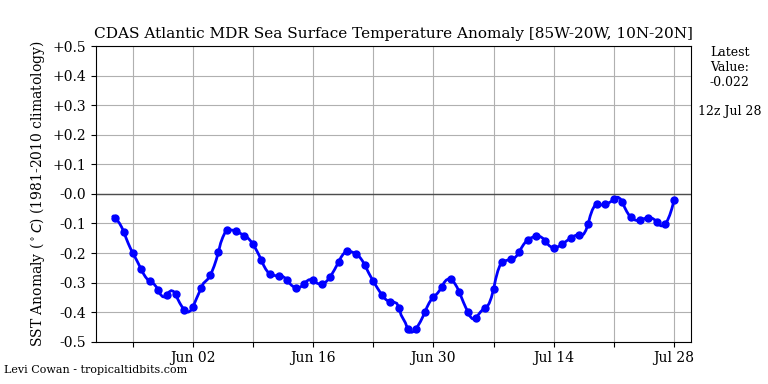
The recent onset of low-level westerlies over the MDR doesn’t seem to be affecting SSTs thus far. Latest values are actually dropping sharply...
On the other hand:
https://twitter.com/webberweather/status/1281731085773176832
https://twitter.com/RoneyJD/status/1281732142599409669
https://twitter.com/MaxLittle92/status/1281772324153368576
Of course, if nothing is able to develop in the MDR during this time frame, there won’t be any storms to take advantage of the steering current.
1 likes
CVW / MiamiensisWx / Shell Mound
The posts in this forum are NOT official forecasts and should not be used as such. They are just the opinion of the poster and may or may not be backed by sound meteorological data. They are NOT endorsed by any professional institution or STORM2K. For official information, please refer to products from the NHC and NWS.
-
Kingarabian
- S2K Supporter
- Posts: 16360
- Joined: Sat Aug 08, 2009 3:06 am
- Location: Honolulu, Hawaii
Re: 2020 Indicators: SST's / SAL / MSLP / Steering / Shear / Instability / Sat Images
Is there a reason why the EPS control is cited more on Twitter recently? Before it was the EPS mean. What's changed?
2 likes
RIP Kobe Bryant
-
JetFuel_SE

- Category 1

- Posts: 287
- Age: 26
- Joined: Thu Apr 30, 2020 3:57 pm
Re: 2020 Indicators: SST's / SAL / MSLP / Steering / Shear / Instability / Sat Images
Shell Mound wrote:https://www.tropicaltidbits.com/analysis/ocean/mdrssta.png
The recent onset of low-level westerlies over the MDR doesn’t seem to be affecting SSTs thus far. Latest values are actually dropping sharply...
On the other hand:
https://twitter.com/webberweather/status/1281731085773176832
https://twitter.com/RoneyJD/status/1281732142599409669
https://twitter.com/MaxLittle92/status/1281772324153368576
Of course, if nothing is able to develop in the MDR during this time frame, there won’t be any storms to take advantage of the steering current.
I wouldn't suggest using CDAS for the MDR, as it has a pretty significant cold bias.
1 likes

Re: 2020 Indicators: SST's / SAL / MSLP / Steering / Shear / Instability / Sat Images
Nothing but dust across the MDR this morning, models show it may start settling down some next week, maybe.

0 likes
-
gatorcane
- S2K Supporter
- Posts: 23708
- Age: 48
- Joined: Sun Mar 13, 2005 3:54 pm
- Location: Boca Raton, FL
Re: 2020 Indicators: SST's / SAL / MSLP / Steering / Shear / Instability / Sat Images
The SAL will eventually subside and the hurricanes will come but the early indicators to me continue to suggest a weaker Bermuda High than seen in 2016-2017 allowing storms to potentially recurve well east of the US and potentially the islands. In years past July featured strong ridging especially 2016-2017. All bets are off though for Western Caribbean or storms that form in the Gulf.
0 likes
Who is online
Users browsing this forum: TeamPlayersBlue and 55 guests