2021 Indicators: SST's / SAL / MSLP / Shear / Steering / Instability / Sat Images
Moderator: S2k Moderators
Forum rules

The posts in this forum are NOT official forecasts and should not be used as such. They are just the opinion of the poster and may or may not be backed by sound meteorological data. They are NOT endorsed by any professional institution or STORM2K. For official information, please refer to products from the National Hurricane Center and National Weather Service.
-
SFLcane

- S2K Supporter

- Posts: 10281
- Age: 48
- Joined: Sat Jun 05, 2010 1:44 pm
- Location: Lake Worth Florida
Re: 2021 Indicators: SST's / SAL / MSLP / Shear / Steering / Instability / Sat Images
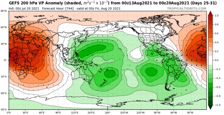
Looking at long-range GEFS this morning and it actually has a very hostile environment into late August now.
0 likes
-
AlphaToOmega
- Category 5

- Posts: 1448
- Joined: Sat Jun 26, 2021 10:51 am
- Location: Somewhere in Massachusetts
Re: 2021 Indicators: SST's / SAL / MSLP / Shear / Steering / Instability / Sat Images
SFLcane wrote:Looking at long-range GEFS this morning and it actually has a very hostile environment into late August now.
https://i.postimg.cc/zXXBbYnx/7-CDE62-C6-AFE8-4-BB0-814-D-42976-F174-B1-B.jpg
I would not trust it. The GFS always wants to kill the WAM.
2 likes
-
SFLcane
- S2K Supporter
- Posts: 10281
- Age: 48
- Joined: Sat Jun 05, 2010 1:44 pm
- Location: Lake Worth Florida
Re: 2021 Indicators: SST's / SAL / MSLP / Shear / Steering / Instability / Sat Images
AlphaToOmega wrote:SFLcane wrote:Looking at long-range GEFS this morning and it actually has a very hostile environment into late August now.
https://i.postimg.cc/zXXBbYnx/7-CDE62-C6-AFE8-4-BB0-814-D-42976-F174-B1-B.jpg
I would not trust it. The GFS always wants to kill the WAM.
Let's give it a week and see because yeah I think it could be a bias.
0 likes
-
cycloneye

- Admin

- Posts: 149504
- Age: 69
- Joined: Thu Oct 10, 2002 10:54 am
- Location: San Juan, Puerto Rico
Re: 2021 Indicators: SST's / SAL / MSLP / Shear / Steering / Instability / Sat Images
It all depends on what happens in WPAC.
https://twitter.com/webberweather/status/1417834562852466689
https://twitter.com/pppapin/status/1417837669887856647
https://twitter.com/webberweather/status/1417834562852466689
https://twitter.com/pppapin/status/1417837669887856647
0 likes
Visit the Caribbean-Central America Weather Thread where you can find at first post web cams,radars
and observations from Caribbean basin members Click Here
and observations from Caribbean basin members Click Here
-
SFLcane
- S2K Supporter
- Posts: 10281
- Age: 48
- Joined: Sat Jun 05, 2010 1:44 pm
- Location: Lake Worth Florida
Re: 2021 Indicators: SST's / SAL / MSLP / Shear / Steering / Instability / Sat Images
cycloneye wrote:It all depends on what happens in WPAC.
https://twitter.com/webberweather/status/1417834562852466689
Luis, nothing abnormal there in any given season activity doesn’t pick up till mid August. If the EPS weeklies are correct it’s a go about after August 15-20 which conditions become quite favorable.
3 likes
-
AutoPenalti
- Category 5
- Posts: 4091
- Age: 29
- Joined: Mon Aug 17, 2015 4:16 pm
- Location: Ft. Lauderdale, Florida
Re: 2021 Indicators: SST's / SAL / MSLP / Shear / Steering / Instability / Sat Images
SFLcane wrote:Looking at long-range GEFS this morning and it actually has a very hostile environment into late August now.
https://i.postimg.cc/zXXBbYnx/7-CDE62-C6-AFE8-4-BB0-814-D-42976-F174-B1-B.jpg
Not the first time the GEFS pushes back the VP time frame.
0 likes
The posts in this forum are NOT official forecasts and should not be used as such. They are just the opinion of the poster and may or may not be backed by sound meteorological data. They are NOT endorsed by any professional institution or STORM2K. For official information, please refer to products from the NHC and NWS.
Model Runs Cheat Sheet:
GFS (5:30 AM/PM, 11:30 AM/PM)
HWRF, GFDL, UKMET, NAVGEM (6:30-8:00 AM/PM, 12:30-2:00 AM/PM)
ECMWF (1:45 AM/PM)
TCVN is a weighted averaged
-
Stormybajan

- Category 1

- Posts: 453
- Joined: Thu May 20, 2021 3:21 pm
- Location: Windward Islands
Re: 2021 Indicators: SST's / SAL / MSLP / Shear / Steering / Instability / Sat Images
SFLcane wrote:Looking at long-range GEFS this morning and it actually has a very hostile environment into late August now.
https://i.postimg.cc/zXXBbYnx/7-CDE62-C6-AFE8-4-BB0-814-D-42976-F174-B1-B.jpg
Hmmm i'll comeback to this August 1st, if its still showing this pattern then I guess we are looking at another back loaded season. Since 2012 only 2017 seemed to have a decently active early-ish August which is interesting
1 likes
Sad West Indies and Manchester United fan ⚽️

Re: 2021 Indicators: SST's / SAL / MSLP / Shear / Steering / Instability / Sat Images
SFLcane wrote:Looking at long-range GEFS this morning and it actually has a very hostile environment into late August now.
https://i.postimg.cc/zXXBbYnx/7-CDE62-C6-AFE8-4-BB0-814-D-42976-F174-B1-B.jpg
That looks like the opposite of what you would see in a cool ENSO year like what 2021 will be. It also doesn’t make sense when looking at what the activity in the EPac and Atlantic has shown: mostly struggling storms in the EPac, and a very good AEW train and early MDR activity in the Atlantic. That, and it’s also in the very long range and subject to change.
Some models are going to bust really badly by peak season. I’m inclined to believe the ones with abnormally unfavorable conditions that don’t match up with what else has been seen and modeled, but it’s still early and it’s entirely possible the favorable forecasts bust instead.
5 likes
Irene '11 Sandy '12 Hermine '16 5/15/2018 Derecho Fay '20 Isaias '20 Elsa '21 Henri '21 Ida '21
I am only a meteorology enthusiast who knows a decent amount about tropical cyclones. Look to the professional mets, the NHC, or your local weather office for the best information.
I am only a meteorology enthusiast who knows a decent amount about tropical cyclones. Look to the professional mets, the NHC, or your local weather office for the best information.
-
Category5Kaiju

- Category 5
- Posts: 4334
- Joined: Thu Dec 24, 2020 12:45 pm
- Location: Seattle and Phoenix
Re: 2021 Indicators: SST's / SAL / MSLP / Shear / Steering / Instability / Sat Images
I mean when was the last recent season to feature a very active early August? In recent years major hurricanes did not occur until mid to late August
1 likes
Unless explicitly stated, all info in my posts is based on my own opinions and observations. Tropical storms and hurricanes can be extremely dangerous. Refer to an accredited weather research agency or meteorologist if you need to make serious decisions regarding an approaching storm.
-
Deshaunrob17
- Tropical Storm

- Posts: 211
- Joined: Tue Aug 18, 2020 7:49 am
Re: 2021 Indicators: SST's / SAL / MSLP / Shear / Steering / Instability / Sat Images
Let's see if the GEFS is right. Last month many were doubting the CFS with the breakdown of the African standing have in July. While it's prediction was a little too robust, it was closer to reality. If the GEFS is right, I'm sure it's not going to be for long since we're heading into a La Nina like pattern
1 likes
Re: 2021 Indicators: SST's / SAL / MSLP / Shear / Steering / Instability / Sat Images
Category5Kaiju wrote:I mean when was the last recent season to feature a very active early August? In recent years major hurricanes did not occur until mid to late August
2012 had a record-tying number of named storms in August, including several hurricanes like Ernesto and Isaac, but none became majors.
2016 had Hurricane Earl in early August, then a bit of a break until TS Fiona and C3 Gaston starting mid-month. This year didn’t have a continuous active phase, as most of September was filled with struggling storms between C1 Hermine at the start and C4 Matthew at the end (no that’s not a typo).
2017 saw C1 Franklin (essential Earl 2.0) in early August, then C2 (almost C3) Gert in mid August, which began the record-breaking streak of continuous named storm days until Maria and Lee dissipated at the end of September. Therefore, we can say that 2017 began its peak phase of activity in mid August.
2018 had a very lackluster August, with two weak subtropical systems — one of which choked on wildfire smoke and died — and didn’t get going until the formation of Florence on August 31st. The start of 2018’s active phase was two weeks later than 2017’s.
2019 had a month-long break between Barry the Abomination and TS Chantal, with Dorian forming the next day on August 24th. Therefore, we can say that 2019’s active phase also started later than 2017, between August 20-25th.
2020 had C1 Isaias from July make it into August and reach peak intensity during the first week of the month, so it’s technically both a July and August hurricane. It then took a break and didn’t have any storms until around August 15th, then the active phase truly began the following week when Laura and Marco formed, a little later than 2017.
All of the seasons in the most recent active streak either had an early August hurricane followed by a break until mid-late August, or had a backloaded month. 2010 and 2011 also didn’t really get going until late August, with 2011 not being able to generate a hurricane until Irene. Therefore, if 2021 also takes a while to really get going…we shouldn’t be surprised.
4 likes
Irene '11 Sandy '12 Hermine '16 5/15/2018 Derecho Fay '20 Isaias '20 Elsa '21 Henri '21 Ida '21
I am only a meteorology enthusiast who knows a decent amount about tropical cyclones. Look to the professional mets, the NHC, or your local weather office for the best information.
I am only a meteorology enthusiast who knows a decent amount about tropical cyclones. Look to the professional mets, the NHC, or your local weather office for the best information.
-
Category5Kaiju
- Category 5
- Posts: 4334
- Joined: Thu Dec 24, 2020 12:45 pm
- Location: Seattle and Phoenix
Re: 2021 Indicators: SST's / SAL / MSLP / Shear / Steering / Instability / Sat Images
Deshaunrob17 wrote:Let's see if the GEFS is right. Last month many were doubting the CFS with the breakdown of the African standing have in July. While it's prediction was a little too robust, it was closer to reality. If the GEFS is right, I'm sure it's not going to be for long since we're heading into a La Nina like pattern
Yeah whatever happens we know this:
1. There's an Atlantic Nino and the ITCZ is pretty south and robust
2. The chances of entering another La Nina is very high
3. We already had an MDR hurricane
Sure those are only 3 signs out of many variables off course, but I still firmly believe that this season will ultimately be quite active and that I simply cannot fathom a 2013 failure as some on social media are once again discussing with these model battles.
0 likes
Unless explicitly stated, all info in my posts is based on my own opinions and observations. Tropical storms and hurricanes can be extremely dangerous. Refer to an accredited weather research agency or meteorologist if you need to make serious decisions regarding an approaching storm.
-
Deshaunrob17
- Tropical Storm
- Posts: 211
- Joined: Tue Aug 18, 2020 7:49 am
Re: 2021 Indicators: SST's / SAL / MSLP / Shear / Steering / Instability / Sat Images
aspen wrote:Category5Kaiju wrote:I mean when was the last recent season to feature a very active early August? In recent years major hurricanes did not occur until mid to late August
2012 had a record-tying number of named storms in August, including several hurricanes like Ernesto and Isaac, but none became majors.
2016 had Hurricane Earl in early August, then a bit of a break until TS Fiona and C3 Gaston starting mid-month. This year didn’t have a continuous active phase, as most of September was filled with struggling storms between C1 Hermine at the start and C4 Matthew at the end (no that’s not a typo).
2017 saw C1 Franklin (essential Earl 2.0) in early August, then C2 (almost C3) Gert in mid August, which began the record-breaking streak of continuous named storm days until Maria and Lee dissipated at the end of September. Therefore, we can say that 2017 began its peak phase of activity in mid August.
2018 had a very lackluster August, with two weak subtropical systems — one of which choked on wildfire smoke and died — and didn’t get going until the formation of Florence on August 31st. The start of 2018’s active phase was two weeks later than 2017’s.
2019 had a month-long break between Barry the Abomination and TS Chantal, with Dorian forming the next day on August 24th. Therefore, we can say that 2019’s active phase also started later than 2017, between August 20-25th.
2020 had C1 Isaias from July make it into August and reach peak intensity during the first week of the month, so it’s technically both a July and August hurricane. It then took a break and didn’t have any storms until around August 15th, then the active phase truly began the following week when Laura and Marco formed, a little later than 2017.
All of the seasons in the most recent active streak either had an early August hurricane followed by a break until mid-late August, or had a backloaded month. 2010 and 2011 also didn’t really get going until late August, with 2011 not being able to generate a hurricane until Irene. Therefore, if 2021 also takes a while to really get going…we shouldn’t be surprised.
Gert (2017) was probably a Cat3 at some point in time in my opinion
1 likes
-
Shell Mound
- Category 5
- Posts: 2432
- Age: 33
- Joined: Thu Sep 07, 2017 3:39 pm
- Location: St. Petersburg, FL → Scandinavia
Re: 2021 Indicators: SST's / SAL / MSLP / Shear / Steering / Instability / Sat Images
Stormybajan wrote:SFLcane wrote:Looking at long-range GEFS this morning and it actually has a very hostile environment into late August now.
https://i.postimg.cc/zXXBbYnx/7-CDE62-C6-AFE8-4-BB0-814-D-42976-F174-B1-B.jpg
Hmmm i'll comeback to this August 1st, if its still showing this pattern then I guess we are looking at another back loaded season. Since 2012 only 2017 seemed to have a decently active early-ish August which is interesting
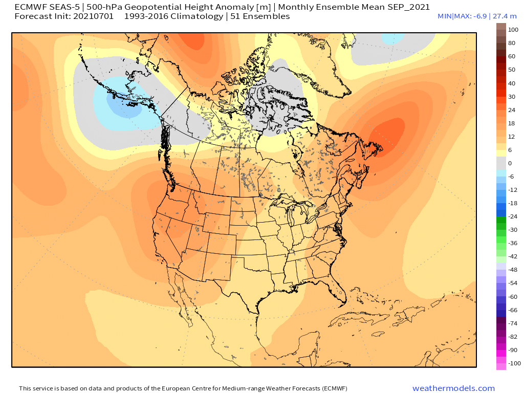


If the 2021 Atlantic hurricane season were to be delayed, for the most part, until the last week of August, then the EPS’s H5 composite for September is startlingly similar to that of the years that featured at least one hurricane impact on Long Island, NY, during the month of September. These years include the infamous seasons of 1938, 1944, 1960, and 1985. When blended with the years 1945 and 1949 as well, the composite becomes even more similar to the EPS’s H5 forecast for September. One interesting difference between the two subsets is that 1945 and 1949 featured a stronger +PNA signature than the years that featured a hurricane impact on Long Island, suggesting a PDO closer to positive rather than negative territory, and the EPS’s forecast suggests more of a neutral PDO/PNA, in line with recent trends indicating a rise in the PDO over the past month or so. This kind of setup would suggest the potential for a CV-type long-tracker that impacts much of the U.S. East Coast from South FL northward to the Carolinas and New England, similar to Donna (1960).
1 likes
CVW / MiamiensisWx / Shell Mound
The posts in this forum are NOT official forecasts and should not be used as such. They are just the opinion of the poster and may or may not be backed by sound meteorological data. They are NOT endorsed by any professional institution or STORM2K. For official information, please refer to products from the NHC and NWS.
-
cycloneye
- Admin
- Posts: 149504
- Age: 69
- Joined: Thu Oct 10, 2002 10:54 am
- Location: San Juan, Puerto Rico
Re: 2021 Indicators: SST's / SAL / MSLP / Shear / Steering / Instability / Sat Images
MJO is going to move according to the new GEFS to get closer to ECMWF. With La Niña developing, what GEFS had to keep the MJO stationary was not physically correct.

5 likes
Visit the Caribbean-Central America Weather Thread where you can find at first post web cams,radars
and observations from Caribbean basin members Click Here
and observations from Caribbean basin members Click Here
-
Category5Kaiju
- Category 5
- Posts: 4334
- Joined: Thu Dec 24, 2020 12:45 pm
- Location: Seattle and Phoenix
Re: 2021 Indicators: SST's / SAL / MSLP / Shear / Steering / Instability / Sat Images
cycloneye wrote:MJO is going to move according to the new GEFS to get closer to ECMWF. With La Niña developing, what GEFS had to keep the MJO stationary was not physically correct.
https://i.imgur.com/8jsb5Uc.gif
Yeah I mean if we were in a warm neutral or El Nino year or perhaps dead neutral then what GEFS had would have been more credible, but we have a very solid and real chance at returning to a La Nina state (weak Nina even perhaps) later this season. I simply cannot see, with that in mind, why the Atlantic would not be favored come mid-August and the rest of the year, it just goes against convention.
3 likes
Unless explicitly stated, all info in my posts is based on my own opinions and observations. Tropical storms and hurricanes can be extremely dangerous. Refer to an accredited weather research agency or meteorologist if you need to make serious decisions regarding an approaching storm.
-
SFLcane
- S2K Supporter
- Posts: 10281
- Age: 48
- Joined: Sat Jun 05, 2010 1:44 pm
- Location: Lake Worth Florida
Re: 2021 Indicators: SST's / SAL / MSLP / Shear / Steering / Instability / Sat Images
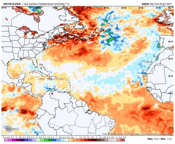
I for one think the GEFS is biased. Speaking of the Mdr we are coming along give it a few weeks.
5 likes
-
AlphaToOmega
- Category 5
- Posts: 1448
- Joined: Sat Jun 26, 2021 10:51 am
- Location: Somewhere in Massachusetts
Re: 2021 Indicators: SST's / SAL / MSLP / Shear / Steering / Instability / Sat Images
Shell Mound wrote:Stormybajan wrote:SFLcane wrote:Looking at long-range GEFS this morning and it actually has a very hostile environment into late August now.
https://i.postimg.cc/zXXBbYnx/7-CDE62-C6-AFE8-4-BB0-814-D-42976-F174-B1-B.jpg
Hmmm i'll comeback to this August 1st, if its still showing this pattern then I guess we are looking at another back loaded season. Since 2012 only 2017 seemed to have a decently active early-ish August which is interesting
https://i.postimg.cc/g0mn1hLM/EC51003-B-BA3-B-48-AB-933-C-1343-E10-E7-CDE.png
https://i.ibb.co/jvrbBbv/LIhurrimpact-2.png
https://i.ibb.co/tQXKZ6J/LIFLhurrcomp-1.png
https://i.ibb.co/51MdKPL/Ska-rmavbild-2021-07-21-kl-16-28-46.png
If the 2021 Atlantic hurricane season were to be delayed, for the most part, until the last week of August, then the EPS’s H5 composite for September is startlingly similar to that of the years that featured at least one hurricane impact on Long Island, NY, during the month of September. These years include the infamous seasons of 1938, 1944, 1960, and 1985. When blended with the years 1945 and 1949 as well, the composite becomes even more similar to the EPS’s H5 forecast for September. One interesting difference between the two subsets is that 1945 and 1949 featured a stronger +PNA signature than the years that featured a hurricane impact on Long Island, suggesting a PDO closer to positive rather than negative territory, and the EPS’s forecast suggests more of a neutral PDO/PNA, in line with recent trends indicating a rise in the PDO over the past month or so. This kind of setup would suggest the potential for a CV-type long-tracker that impacts much of the U.S. East Coast from South FL northward to the Carolinas and New England, similar to Donna (1960).
What are you using for the storm tracks?
0 likes
-
Shell Mound
- Category 5
- Posts: 2432
- Age: 33
- Joined: Thu Sep 07, 2017 3:39 pm
- Location: St. Petersburg, FL → Scandinavia
Re: 2021 Indicators: SST's / SAL / MSLP / Shear / Steering / Instability / Sat Images
AlphaToOmega wrote:Shell Mound wrote:Stormybajan wrote:
Hmmm i'll comeback to this August 1st, if its still showing this pattern then I guess we are looking at another back loaded season. Since 2012 only 2017 seemed to have a decently active early-ish August which is interesting
https://i.postimg.cc/g0mn1hLM/EC51003-B-BA3-B-48-AB-933-C-1343-E10-E7-CDE.png
https://i.ibb.co/jvrbBbv/LIhurrimpact-2.png
https://i.ibb.co/tQXKZ6J/LIFLhurrcomp-1.png
https://i.ibb.co/51MdKPL/Ska-rmavbild-2021-07-21-kl-16-28-46.png
If the 2021 Atlantic hurricane season were to be delayed, for the most part, until the last week of August, then the EPS’s H5 composite for September is startlingly similar to that of the years that featured at least one hurricane impact on Long Island, NY, during the month of September. These years include the infamous seasons of 1938, 1944, 1960, and 1985. When blended with the years 1945 and 1949 as well, the composite becomes even more similar to the EPS’s H5 forecast for September. One interesting difference between the two subsets is that 1945 and 1949 featured a stronger +PNA signature than the years that featured a hurricane impact on Long Island, suggesting a PDO closer to positive rather than negative territory, and the EPS’s forecast suggests more of a neutral PDO/PNA, in line with recent trends indicating a rise in the PDO over the past month or so. This kind of setup would suggest the potential for a CV-type long-tracker that impacts much of the U.S. East Coast from South FL northward to the Carolinas and New England, similar to Donna (1960).
What are you using for the storm tracks?
https://coast.noaa.gov/hurricanes/
As an aside, why are you using 2004 and 2017 as analogs for 2021 in some of your previous posts? Do you have any evidence? Those are extreme years.
0 likes
CVW / MiamiensisWx / Shell Mound
The posts in this forum are NOT official forecasts and should not be used as such. They are just the opinion of the poster and may or may not be backed by sound meteorological data. They are NOT endorsed by any professional institution or STORM2K. For official information, please refer to products from the NHC and NWS.
-
Shell Mound
- Category 5
- Posts: 2432
- Age: 33
- Joined: Thu Sep 07, 2017 3:39 pm
- Location: St. Petersburg, FL → Scandinavia
Re: 2021 Indicators: SST's / SAL / MSLP / Shear / Steering / Instability / Sat Images
SFLcane wrote:I for one think the GEFS is biased. Speaking of the Mdr we are coming along give it a few weeks.
https://i.postimg.cc/vmT3vwTY/EE641453-BE09-49-E2-98-A1-BEE4-CF63-FA67.jpg
That looks like a classic -AMM/-AMO. It barely seems to have changed over the past few months. Models have consistently shown too much warming.
0 likes
CVW / MiamiensisWx / Shell Mound
The posts in this forum are NOT official forecasts and should not be used as such. They are just the opinion of the poster and may or may not be backed by sound meteorological data. They are NOT endorsed by any professional institution or STORM2K. For official information, please refer to products from the NHC and NWS.
Who is online
Users browsing this forum: AnnularCane, cycloneye, Google Adsense [Bot], hurricanes1234 and 205 guests