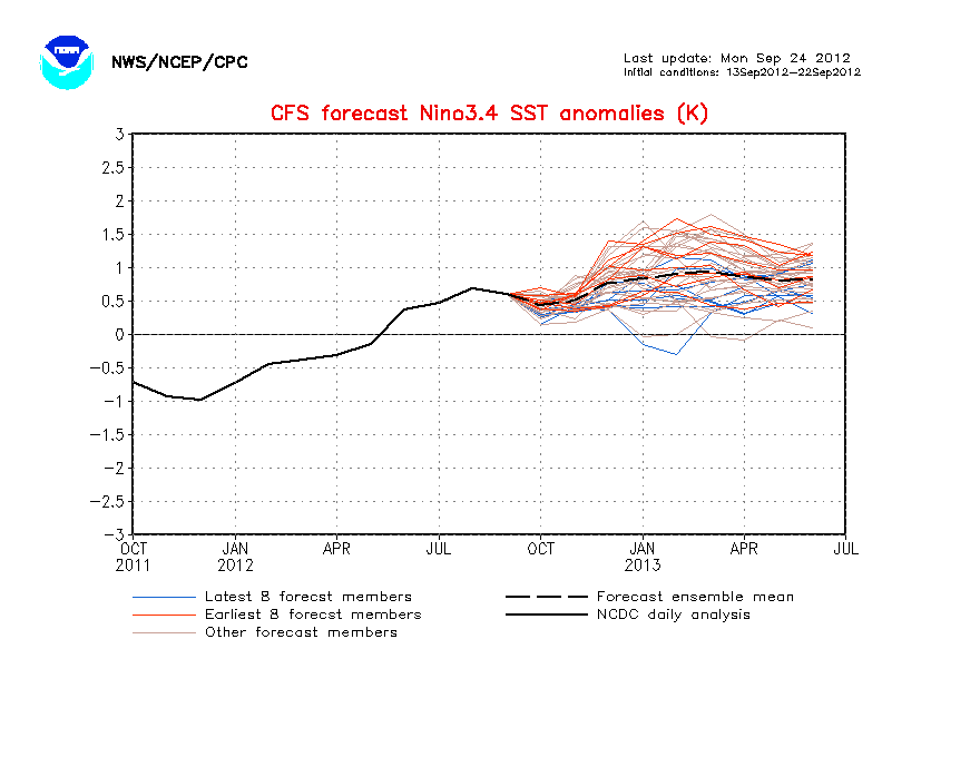
ENSO Updates (2007 thru 2023)

This is the general tropical discussion area. Anyone can take their shot at predicting a storms path.

Moderator: S2k Moderators

Forum rules

The posts in this forum are NOT official forecasts and should not be used as such. They are just the opinion of the poster and may or may not be backed by sound meteorological data. They are NOT endorsed by any professional institution or STORM2K. For official information, please refer to products from the National Hurricane Center and National Weather Service.

Help Support Storm2K
Message
Author
User avatar
cycloneye
Admin
Admin
Posts: 145296
Age: 68
Joined: Thu Oct 10, 2002 10:54 am
Location: San Juan, Puerto Rico

Re: ENSO=CPC 7/12/10 update=Nino 3.4 down to -0.8C

#1501 Postby cycloneye » Mon Jul 12, 2010 9:49 am

Climate Prediction Center 7/12/10 Weekly Update

La Nina continues to expand and deepen. The only question pending is how strong La Nina will be in the next few months.

Last Week Numbers

Niño 4= -0.2ºC
Niño 3.4= -0.6ºC
Niño 3= -0.7ºC
Niño1+2= -0.9ºC


This Week Numbers

Niño 4= -0.4ºC
Niño 3.4= -0.8ºC
Niño 3= -1.0ºC
Niño1+2= -1.3ºC


http://www.cpc.ncep.noaa.gov/products/a ... ts-web.pdf

Image
0 likes   
Visit the Caribbean-Central America Weather Thread where you can find at first post web cams,radars
and observations from Caribbean basin members Click Here

User avatar
cycloneye
Admin
Admin
Posts: 145296
Age: 68
Joined: Thu Oct 10, 2002 10:54 am
Location: San Juan, Puerto Rico

Re: ENSO=CPC 7/12/10 update=Nino 3.4 down to -0.8C

#1502 Postby cycloneye » Mon Jul 12, 2010 1:23 pm

Dip,Dip,Dip....... Wow, the CFS (NCEP) model continues going down more and more as the days pass,today almost at -2.0C that means strong La Nina.

http://www.cpc.ncep.noaa.gov/products/a ... cast.shtml

Image
0 likes   
Visit the Caribbean-Central America Weather Thread where you can find at first post web cams,radars
and observations from Caribbean basin members Click Here

lonelymike
S2K Supporter
S2K Supporter
Posts: 634
Joined: Sat Jul 26, 2008 10:12 am
Location: walton county fla

Re: ENSO=CPC 7/12/10 update=Nino 3.4 down to -0.8C

#1503 Postby lonelymike » Mon Jul 12, 2010 4:15 pm

I borrowed this from Ed Dunham's blog over at CFHC. Thought it was an interesting take:

“About a month ago I did a little research from a slightly different angle. Since ENSO conditions are only available from 1950, I decided to check El Nino Region 3.4 anomalies against all of the very active seasons since 1950. I defined an active season as 14 named storms or more (there have been 10 of these) and ENSO neutral conditions as anything from +0.5C to -0.5C. I used the average sea surface temperature anomaly for the three month period of May, June and July (figuring that a three month lag was reasonable between Pacific ENSO conditions and Atlantic activity). The results coincide nicely with the findings of Ostro & Lyons.

1953...14 storms...+0.4 anomaly
1969...17 storms...+0.4 anomaly
1990...14 storms...+0.3 anomaly
1995...19 storms...+0.1 anomaly
1998...14 storms...+0.1 anomaly
2000...14 storms...-0.6 anomaly (weakening La Nina)
2001...15 storms...+0.1 anomaly
2003...15 storms.....0.0 anomaly
2004...15 storms...+0.4 anomaly
2005...28 storms...+0.3 anomaly”

Since that 2007 post, we can add 2007 and 2008 to the list (and they both continued the association of an ENSO neutral SST anomaly in May/June/July with high-activity seasons). Note that it does not mean that ENSO neutral conditions in M/J/J will always yield a high-activity season – it just means that previous high-activity seasons (since 1950) almost always occurred when ENSO neutral conditions (-0.5C to +0.5C) were observed at the beginning of the season.

2007…15 storms…-0.1 anomaly
2008…16 storms…-0.4 anomaly

A few months ago, the April/May/June ENSO SST anomaly was forecast to be 0.0C, but it came in at +0.3C. The May/June/July forecast was -0.5C but so far it looks like it will end up closer to -0.2C. The implication is that the upcoming La Nina event was overforecasted, i.e., too soon and too strong.

There is no previous season since 1950 that matches the current season SST anomaly to date, and the SST anomaly outlook for the remainder of the current season. 1998 is about the closest season for an SST trend except that is started with a stronger El Nino and ended with a strong La Nina. The storm totals in 1998 were 14/10/3. 1970 somewhat matches the expected SST outlook for the remainder of this season and the storm totals in 1970 were 10/5/2, but 1970 did not start with a robust El Nino.
ED
0 likes   


GO SEMINOLES
HURRICANELONNY
Category 5
Category 5
Posts: 1383
Joined: Wed May 07, 2003 6:48 am
Location: HOLLYWOOD.FL

Re: ENSO=CPC 7/12/10 update=Nino 3.4 down to -0.8C

#1504 Postby HURRICANELONNY » Mon Jul 12, 2010 5:54 pm

That sounds about right to me. That is some good stuff that Ed researched. I think the NHC jumped the gun this year. No neutral this season. All La Nina. It seems to me it coincides more with 98. Not 2005. My guess is 15 storms. Not including Alex. I guess that means 16. :roll:
0 likes   
hurricanelonny

User avatar
cycloneye
Admin
Admin
Posts: 145296
Age: 68
Joined: Thu Oct 10, 2002 10:54 am
Location: San Juan, Puerto Rico

Re: ENSO=CPC 7/12/10 update=Nino 3.4 down to -0.8C

#1505 Postby cycloneye » Mon Jul 12, 2010 6:03 pm

HURRICANELONNY wrote:That sounds about right to me. That is some good stuff that Ed researched. I think the NHC jumped the gun this year. No neutral this season. All La Nina. It seems to me it coincides more with 98. Not 2005. My guess is 15 storms. Not including Alex. I guess that means 16. :roll:


From May 27 NOAA outlook.

http://www.cpc.noaa.gov/products/outloo ... cane.shtml

This outlook reflects an expected set of conditions that is very conducive to increased Atlantic hurricane activity. This expectation is based on the prediction of three climate factors, all of which are conducive historically to increased tropical cyclone activity. These climate factors are: 1) the tropical multi-decadal signal, which has contributed to the high-activity era in the Atlantic basin that began in 1995, 2) exceptionally warm sea surface temperatures in the tropical Atlantic Ocean and Caribbean Sea (called the Main Development Region), and 3) either ENSO-neutral or La Niña conditions in the tropical Pacific, with La Niña becoming increasingly likely. In addition, dynamical models forecasts of the number and strength of tropical cyclones also predict a very active season.
0 likes   
Visit the Caribbean-Central America Weather Thread where you can find at first post web cams,radars
and observations from Caribbean basin members Click Here

User avatar
KWT
Category 5
Category 5
Posts: 31415
Joined: Tue Aug 17, 2004 11:02 am
Location: UK!!!

#1506 Postby KWT » Mon Jul 12, 2010 6:35 pm

La Nina more or less at a similar stage to what we had in 1998 at the moment, we can therefore see whether an idea I've had about struggling to go above 15NS actually comes off as we should reach moderate for ASO from the looks of things.

Indeed 1998 matches the whole broad pattern quite well at the moment.
0 likes   
Personal Forecast Disclaimer:
The posts in this forum are NOT official forecast and should not be used as such. They are just the opinion of the poster and may or may not be backed by sound meteorological data. They are NOT endorsed by any professional institution or storm2k.org. For official information, please refer to the NHC and NWS products

HURRICANELONNY
Category 5
Category 5
Posts: 1383
Joined: Wed May 07, 2003 6:48 am
Location: HOLLYWOOD.FL

Re: ENSO=CPC 7/12/10 update=Nino 3.4 down to -0.8C

#1507 Postby HURRICANELONNY » Mon Jul 12, 2010 8:17 pm

I think it will be above normal this year. I just don't see 18+ names. Most sites never predicted 2005. Maybe they're just covering there ass. In case it happens again. I don't think all the variables that were in place in 05 are here this year. All I'm talking about is #'s. If I get wiped out by a major and that was the only landfall. It was a bad year. :eek:
0 likes   
hurricanelonny

User avatar
cycloneye
Admin
Admin
Posts: 145296
Age: 68
Joined: Thu Oct 10, 2002 10:54 am
Location: San Juan, Puerto Rico

Re: ENSO=CPC 7/12/10 update=Nino 3.4 down to -0.8C

#1508 Postby cycloneye » Tue Jul 13, 2010 3:46 pm

The Aussies are almost on the same page as Climate Prediction Center on nino 3.4 data.

Image
0 likes   
Visit the Caribbean-Central America Weather Thread where you can find at first post web cams,radars
and observations from Caribbean basin members Click Here

User avatar
KWT
Category 5
Category 5
Posts: 31415
Joined: Tue Aug 17, 2004 11:02 am
Location: UK!!!

Re: ENSO=CPC 7/12/10 update=Nino 3.4 down to -0.8C

#1509 Postby KWT » Tue Jul 13, 2010 4:00 pm

HURRICANELONNY wrote:I think it will be above normal this year. I just don't see 18+ names. Most sites never predicted 2005. Maybe they're just covering there ass. In case it happens again. I don't think all the variables that were in place in 05 are here this year. All I'm talking about is #'s. If I get wiped out by a major and that was the only landfall. It was a bad year. :eek:


Yeah I'm starting to think the same, thats not to say we won't have a huge season just probably not quite as high as most seasons...a moderate La nina in the summer never usually go above 14NS in terms of numbers because the surpressed starts.
0 likes   
Personal Forecast Disclaimer:
The posts in this forum are NOT official forecast and should not be used as such. They are just the opinion of the poster and may or may not be backed by sound meteorological data. They are NOT endorsed by any professional institution or storm2k.org. For official information, please refer to the NHC and NWS products

User avatar
srainhoutx
S2K Supporter
S2K Supporter
Posts: 6919
Age: 67
Joined: Sun Jan 14, 2007 11:34 am
Location: Haywood County, NC
Contact:

Re: ENSO Updates

#1510 Postby srainhoutx » Wed Jul 14, 2010 9:33 am

Image
0 likes   
Carla/Alicia/Jerry(In The Eye)/Michelle/Charley/Ivan/Dennis/Katrina/Rita/Wilma/Ike/Harvey

Member: National Weather Association
Wx Infinity Forums
http://wxinfinity.com/index.php

Facebook.com/WeatherInfinity
Twitter @WeatherInfinity

User avatar
cycloneye
Admin
Admin
Posts: 145296
Age: 68
Joined: Thu Oct 10, 2002 10:54 am
Location: San Juan, Puerto Rico

Re: ENSO Updates

#1511 Postby cycloneye » Thu Jul 15, 2010 11:39 am

From Climate Prediction Center long range seasonal outlook:

http://www.cpc.ncep.noaa.gov/products/p ... xus05.html

DEVELOPING LA NINA CONDITIONS FAVOR ABOVE MEDIAN PRECIPITATION AMOUNTS FOR THE
GULF AND SOUTHERN ATLANTIC COASTS IN ASO 2010, CONSISTENT WITH THE NOAA
FORECAST OF AN ACTIVE ATLANTIC TROPICAL STORM SEASON AND DECADAL PRECIPITATION
TRENDS. THE CHANCES OF ABOVE MEDIAN PRECIPITATION AMOUNTS ARE ALSO ENHANCED
OVER PARTS OF THE CENTRAL AND NORTHERN PLAINS, MAINLY DUE TO DECADAL TRENDS BUT
ALSO CONSISTENT WITH THE DEVELOPING LA NINA. IN LOCATIONS WHERE THE
LIKELIHOODS OF SEASONAL MEAN TEMPERATURES AND SEASONAL PRECIPITATION AMOUNTS
ARE SIMILAR TO THE CLIMATOLOGICAL PROBABILITIES, EQUAL CHANCES OF BELOW, NEAR,
AND ABOVE AVERAGE TEMPERATURE AND PRECIPITATION ARE INDICATED.
0 likes   
Visit the Caribbean-Central America Weather Thread where you can find at first post web cams,radars
and observations from Caribbean basin members Click Here

User avatar
cycloneye
Admin
Admin
Posts: 145296
Age: 68
Joined: Thu Oct 10, 2002 10:54 am
Location: San Juan, Puerto Rico

Re: ENSO Updates

#1512 Postby cycloneye » Thu Jul 15, 2010 1:21 pm

Dr Jeff Masters discussion about La Nina.

Posted by: JeffMasters, 1:16 PM GMT on July 15, 2010

The equatorial Eastern Pacific Ocean continues to cool, and we have now crossed the threshold into La Niña conditions. Sea surface temperatures (SSTs) over the tropical Eastern Pacific in the area 5°N - 5°S, 120°W - 170°W, also called the "Niña 3.4 region", fell to 0.8°C below average by July 12, according to NOAA.. The Australian Bureau of Meteorology put this number at 0.7°C below average (as of July 11.) Since La Niña conditions are defined as occurring when this number reaches 0.5°C below average, we are well into the territory of a weak La Niña event. La Niña conditions must be present for several months before this will be officially classified as a La Niña event, but it is highly likely that a full-fledged La Niña event lasting at least eight months has arrived. We started out the year with a strong El Niño, so it may seem surprising that we have transitioned La Niña so quickly, However, historically, about 35 - 40% of El Niño events are followed by a La Niña within the same year. Given current trends, I expect the current La Niña to cross the threshold needed to be defined as "moderate" strength--temperatures at least 1.0°C below average in the equatorial Eastern Pacific--by September.

The implications

It is well-known that both the number and intensity of hurricanes in the Atlantic tend to increase during La Niña events. However, as I discussed in a post last month, since 1995, neutral years (when neither an El Niño or La Niña are present) have had Atlantic hurricane activity equal to La Niña years. The last time we had a strong El Niño event followed by a La Niña event in the same year, in 1998, we had a Atlantic hurricane season 40% above average in activity, with 14 named storms, 10 hurricanes, and 3 intense hurricanes. The season was relatively late-starting, with only one named storm occurring before August 20. I'm thinking this year's season may be similar, though four or more intense hurricanes are a good bet due to the record warm SSTs.

Both El Niño and La Niña events have major impacts on regional and global weather patterns. For the remainder of July and August, we can expect La Niña to bring cloudier and wetter than average conditions to the Caribbean, but weather patterns over North America should not see much impact (Figure 2.) Globally, La Niña conditions tend to cause a net cooling of surface temperatures. Thus, while the past twelve month period has been the warmest globally since record keeping began in 1880, it is unlikely that the calendar year of 2010 will set the record for warmest year ever.
0 likes   
Visit the Caribbean-Central America Weather Thread where you can find at first post web cams,radars
and observations from Caribbean basin members Click Here

User avatar
cycloneye
Admin
Admin
Posts: 145296
Age: 68
Joined: Thu Oct 10, 2002 10:54 am
Location: San Juan, Puerto Rico

Re: ENSO Updates

#1513 Postby cycloneye » Thu Jul 15, 2010 10:52 pm

cycloneye wrote:One more signal that La Nina is here,is the SOI index that continues strongly in positive territory. The holdout for declaring ENSO officially in La Nina status is Climate Prediction Center, but as I posted last week, they said in the last bulletin La Nina will be declared by late July or in August. The pending question is how strong this La Nina will be,but some ENSO models are very bullish on a moderate to strong La Nina.

Daily SOI Values

http://www.longpaddock.qld.gov.au/seaso ... /index.php

Daily 30 day SOI Text

http://www.bom.gov.au/climate/enso/soi.txt


Image


After the above post four days ago when the 30 day SOI index was around +7, it has continued to go up, now at +11.9.This means that La Nina is getting stronger and as a few ENSO model are forecasting, we may see a Moderate to Strong La Nina by September.
0 likes   
Visit the Caribbean-Central America Weather Thread where you can find at first post web cams,radars
and observations from Caribbean basin members Click Here

User avatar
cycloneye
Admin
Admin
Posts: 145296
Age: 68
Joined: Thu Oct 10, 2002 10:54 am
Location: San Juan, Puerto Rico

Re: ENSO=IRI ENSO Models July Update=Weak La Nina is present

#1514 Postby cycloneye » Fri Jul 16, 2010 1:18 pm

Here is the July update by all the ENSO models and as you can see,almost all are below Neutral status.Below is the July graphic and discussion by IRI.

http://iri.columbia.edu/climate/ENSO/cu ... pdate.html

Image

Summary
Following the dissipation of the 2009/10 El Niño in early May 2010, a brief period of ENSO-neutral conditions was observed until mid-June, when weak La Niña conditions emerged. For the July-September season currently in progress, there is an approximately 80% probability for continuing La Niña conditions, and a 20% probability for returning neutral ENSO conditions. Probabilities for La Niña conditions continue at approximately 80% through the remainder of 2010.

General Discussion

By mid-July, the NINO3.4 SST anomaly index decreased to values indicative of weak La Niña levels (roughly three-quarters of a degree C below average). Zonal wind anomalies in the equatorial Pacific have featured slightly stronger than average easterlies, and subsurface heat content became well below average by mid-May as the El Niño rapidly ended, soon to be replaced by the current weak but strengthening La Niño conditions.

Out of a large set of dynamical and statistical prediction models, 82% indicate maintenance of La Niña conditions during the upcoming July-August-September season, while 18% indicate a return to ENSO-neutral conditions. Overall, based on model predictions and current observations of the ocean surface and subsurface, for the coming August-October season and throughout the remainder of 2010 the probability for La Niña conditions is estimated at near 80%, and for ENSO-neutral conditions approximately 20%. Probabilities for a return to El Niño conditions are negligible through early 2011.
0 likes   
Visit the Caribbean-Central America Weather Thread where you can find at first post web cams,radars
and observations from Caribbean basin members Click Here

User avatar
cycloneye
Admin
Admin
Posts: 145296
Age: 68
Joined: Thu Oct 10, 2002 10:54 am
Location: San Juan, Puerto Rico

Re: ENSO UPDATES

#1515 Postby cycloneye » Mon Jul 19, 2010 9:59 am

Climate Prediction Center Weekly Update

Nino 3.4 continues to go down,now to -1.0C.meaning,La Nina is in firm control and continues to get stronger.The question continues to be,how strong it will be by the peak of the season in ASO?

Last Week Numbers

Niño 4= -0.4ºC
Niño 3.4= -0.8ºC
Niño 3= -1.0ºC
Niño1+2= -1.3ºC


This Week Numbers

Niño 4= -0.4ºC
Niño 3.4= -1.0ºC
Niño 3= -1.0ºC
Niño1+2= -1.8ºC


http://www.cpc.ncep.noaa.gov/products/a ... ts-web.pdf

Image
0 likes   
Visit the Caribbean-Central America Weather Thread where you can find at first post web cams,radars
and observations from Caribbean basin members Click Here

User avatar
KWT
Category 5
Category 5
Posts: 31415
Joined: Tue Aug 17, 2004 11:02 am
Location: UK!!!

#1516 Postby KWT » Mon Jul 19, 2010 11:55 am

Looking like its going to be a solid moderate, which probably explains partly why the first the first few months of the season may have been so slow...
0 likes   
Personal Forecast Disclaimer:
The posts in this forum are NOT official forecast and should not be used as such. They are just the opinion of the poster and may or may not be backed by sound meteorological data. They are NOT endorsed by any professional institution or storm2k.org. For official information, please refer to the NHC and NWS products

StormClouds63
Category 2
Category 2
Posts: 583
Age: 62
Joined: Tue May 13, 2008 11:56 am
Location: Southwest Louisiana

Re: ENSO=CPC 7/19/10 Weekly Update=Nino 3.4 down to -1.0C

#1517 Postby StormClouds63 » Mon Jul 19, 2010 12:11 pm

KWT:

Does a moderate to strong LaNina mean a busier season for September and October, but less so for July and August?
0 likes   

User avatar
KWT
Category 5
Category 5
Posts: 31415
Joined: Tue Aug 17, 2004 11:02 am
Location: UK!!!

#1518 Postby KWT » Mon Jul 19, 2010 12:13 pm

Usually that is the case, though in recent times often there isn't a lot of difference between the two other then the neutral seasons tend to get going a little sharper.
0 likes   
Personal Forecast Disclaimer:
The posts in this forum are NOT official forecast and should not be used as such. They are just the opinion of the poster and may or may not be backed by sound meteorological data. They are NOT endorsed by any professional institution or storm2k.org. For official information, please refer to the NHC and NWS products

User avatar
cycloneye
Admin
Admin
Posts: 145296
Age: 68
Joined: Thu Oct 10, 2002 10:54 am
Location: San Juan, Puerto Rico

Re: ENSO UPDATES

#1519 Postby cycloneye » Fri Jul 23, 2010 7:53 pm

The SOI is going to the roof now as La Nina is getting stronger. Brunota, the 90 day SOI also going up fast,tonight at +8.24.

Image

http://www.longpaddock.qld.gov.au/seaso ... soivalues/
0 likes   
Visit the Caribbean-Central America Weather Thread where you can find at first post web cams,radars
and observations from Caribbean basin members Click Here

User avatar
abajan
S2K Supporter
S2K Supporter
Posts: 4230
Joined: Sun Sep 07, 2003 5:10 am
Location: Barbados

Re:

#1520 Postby abajan » Sat Jul 24, 2010 4:20 am

KWT wrote:Looking like its going to be a solid moderate, which probably explains partly why the first the first few months of the season may have been so slow...
But activity for this season has been normal (even above normal) thus far: A Cat2 hurricane, a TD and a TS.
0 likes   


Return to “Talkin' Tropics”

Who is online

Users browsing this forum: Kingarabian and 43 guests