SFLcane wrote:
Weaker ridge? Na.. That is actually a very dangerous look for the Florida peninsula if that were to pan out.
I’m thinking more the Carolinas into the Northeast U.S. are at highest risk in my opinion.
Moderator: S2k Moderators

SFLcane wrote:
Weaker ridge? Na.. That is actually a very dangerous look for the Florida peninsula if that were to pan out.


TheStormExpert wrote:SFLcane wrote:
Weaker ridge? Na.. That is actually a very dangerous look for the Florida peninsula if that were to pan out.
I’m thinking more the Carolinas into the Northeast U.S. are at highest risk in my opinion.

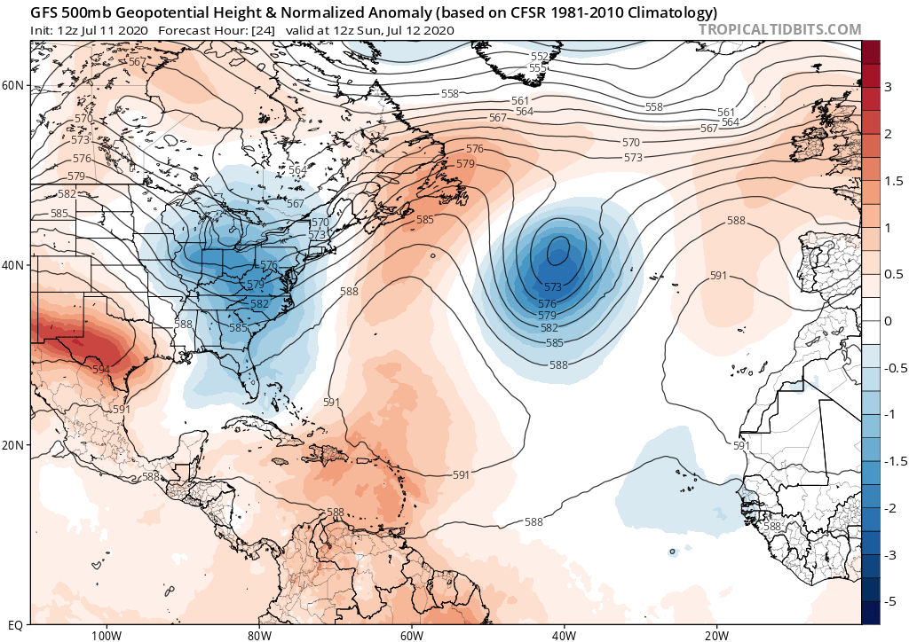
gatorcane wrote:In 2016 and 2017 as well as 2015 most of the daily storms over South Florida were pinned along the west coast each day in June and July which lasted weeks on end with temporary steering flow changes here and there because of a strong Bermuda High anchored over the SW Atlantic, not so much last year or this year so far. In 2016 and 2017, that pattern was suggesting (really telegraphing) something could roll in from the east and in both years something did (Matthew and Irma). Even 2015 something did but the El Nino saved us (Hermine). This year again, things are stagnant with weak steering. It is more of a typical pattern with just seabreeze-driven convection and SW to NE steering over the peninsula as well. Of course the pattern can and will change. Something from the south (Caribbean) is entirely possible.
We have seen a lot of this so far this spring and summer with the Bermuda High displaced well to the east and lower heights over the east coast of the US and Western Atlantic:
https://i.postimg.cc/FzpH2bTc/gfs-z500a-Norm-atl-5.png


gatorcane wrote:In 2016 and 2017 as well as 2015 most of the daily storms over South Florida were pinned along the west coast each day in June and July which lasted weeks on end with temporary steering flow changes here and there because of a strong Bermuda High anchored over the SW Atlantic, not so much last year or this year so far. In 2016 and 2017, that pattern was suggesting (really telegraphing) something could roll in from the east and in both years something did (Matthew and Irma). Even 2015 something did but the El Nino saved us (Hermine). This year again, things are stagnant with weak steering. It is more of a typical pattern with just seabreeze-driven convection and SW to NE steering over the peninsula as well. Of course the pattern can and will change. Something from the south (Caribbean) is entirely possible.
We have seen a lot of this so far this spring and summer with the Bermuda High displaced well to the east and lower heights over the east coast of the US and Western Atlantic:
[postimg.cc/FzpH2bTc/gfs-z500a-Norm-atl-5.png[/img]
NDG wrote:gatorcane wrote:In 2016 and 2017 as well as 2015 most of the daily storms over South Florida were pinned along the west coast each day in June and July which lasted weeks on end with temporary steering flow changes here and there because of a strong Bermuda High anchored over the SW Atlantic, not so much last year or this year so far. In 2016 and 2017, that pattern was suggesting (really telegraphing) something could roll in from the east and in both years something did (Matthew and Irma). Even 2015 something did but the El Nino saved us (Hermine). This year again, things are stagnant with weak steering. It is more of a typical pattern with just seabreeze-driven convection and SW to NE steering over the peninsula as well. Of course the pattern can and will change. Something from the south (Caribbean) is entirely possible.
We have seen a lot of this so far this spring and summer with the Bermuda High displaced well to the east and lower heights over the east coast of the US and Western Atlantic:
https://i.postimg.cc/FzpH2bTc/gfs-z500a-Norm-atl-5.png
A lot of the experts see strong ridging developing across the NE US and SE Canada during the heart of the hurricane season.
If you really look back, 2017's Bermuda ridge was not that strong because 2 of the 3 major hurricanes that came across the eastern Caribbean tracked north of Hispaniola with 2 of them never threatening the US. Harvey tracked into TX because it remained weak through the Caribbean. When the Bermuda ridge is as its strongest the storms go south of FL into the GOM, MX or C.A.
2004 had a troughiness pattern across the eastern US but by the heart of the hurricane season ridging in SE Canada and NE US took over thus why FL had so many landfalls.
2008 also had a similar shift in the pattern by the heart of the hurricane season.
Despite the near neutral to negative NAO index since June 1st ridging across the northern Atlantic has been strong.
https://i.imgur.com/2SV2B93.gif
On the flip side there is 2010's -NAO pattern that developed during the heart of the hurricane season. During June, July & Aug the eastern US had strong ridging with, but by September troughiness developed across the eastern US and western Atlantic, they all recurved OTS.
https://i.imgur.com/Qno3A6B.gif
https://i.imgur.com/F5EIUad.gif


USTropics wrote:One aspect of forecasting that's extremely difficult to predict, even 10 days in advance, are steering currents. The skill forecast at seasonal levels is exponentially lower in skill, and for good reasons – it's trivial to say anything beyond "this area has slightly increased chance of seeing activity" this far in advance. Not only do we have the variability of seasonal changes (see 2004, 2010), but there is no adequate way to forecast mesoscale features that impact steering currents (see Dorian, Matthew). Dorian is a perfect example--24 hours faster, that mesoscale feature that developed over the Midwest doesn’t develop in time, and Dorian likely landfalls (and stalls) in Florida. 24 hours slower, and Dorian doesn’t devastate the Bahamas.
What we can do is look at current patterns, forecasted patterns, and surmise a general pattern of where storms may track (e.g. quick recurves, subtropics, Caribbean, or western Atlantic). We also must take into account where these storms are likely to form and strengthen. For instance, 23 of the 28 storms that formed in 2005 actually reached their highest intensity peaks in the subtropics/northern Atlantic. All but one of the landfalling hurricanes – Cindy, Dennis, Emily, Katrina, Rita, Wilma, Stan, Beta – had delayed formation until reaching the Caribbean or Bahamas (Emily formed in the MDR, but really struggled until it reached the Caribbean).
All storms that reached hurricane strength in 2005
https://i.imgur.com/AKQz1EB.png
So essentially, we must identify pockets where steering currents favor westward tracks and potential AEWs that could form during these pockets (which is low-skill 10+ days). I’m not so worried about systems forming in the MDR (while long trackers can make landfall, it’s rare). It’s the waves that don’t immediately form and find a (so far) favorable western Atlantic that has me most concerned.


CyclonicFury wrote:It appears we are heading in to our usual late July/early August lull that separates the early season from peak season. The Atlantic could go 2-4 weeks without a tropical cyclone, but considering July only averages one named storm or so that wouldn't be surprising.
The MDR isn't ready yet. The past two years it didn't get going until the last week of August for the most part. It could be a bit sooner this year considering the more favorable base state, warmer MDR, and less north displaced west African ITF.
There have been many hyperactive seasons without a hurricane in July, I knew a lot were bullish on one forming on the poll but I was not. We'll see if something pops up towards the end of the month, but barring an unexpected spinup the next 7-10 days at least look dead. I still expect a very active peak, and unless we get to the last week of August without any signs of activity in the deep tropics, I will hold firm on that prediction.
TheStormExpert wrote:Chaserdude Josh Morgerman notorious for riding out Hurricane Dorian in Marsh Harbor last September is ready for anything that comes barreling towards the U.S.!
https://twitter.com/iCyclone/status/1282116120061849602
Users browsing this forum: No registered users and 57 guests


