SFLcane wrote:Luis....
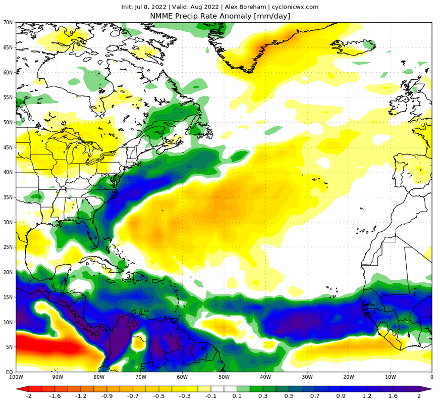
Caribbean-Florida connection? The entire Florida peninsula is wet on this new NMME .
https://i.postimg.cc/DZf0p76q/FLORIDA.png
Yeah I also have to open the eyes for Caribbean.
Moderator: S2k Moderators


SFLcane wrote:Luis....
Caribbean-Florida connection? The entire Florida peninsula is wet on this new NMME .
https://i.postimg.cc/DZf0p76q/FLORIDA.png


cycloneye wrote:SFLcane wrote:Luis....
Caribbean-Florida connection? The entire Florida peninsula is wet on this new NMME .
https://i.postimg.cc/DZf0p76q/FLORIDA.png
Yeah I also have to open the eyes for Caribbean.


SFLcane wrote:Luis....
Caribbean-Florida connection? The entire Florida peninsula is wet on this new NMME .
https://i.postimg.cc/DZf0p76q/FLORIDA.png
NotSparta wrote:SFLcane wrote:Luis....
Caribbean-Florida connection? The entire Florida peninsula is wet on this new NMME .
https://i.postimg.cc/DZf0p76q/FLORIDA.png
Not sure about that. They're kind of disconnected. Would more suggest fronts I'd guess
NotSparta wrote:SFLcane wrote:Luis....
Caribbean-Florida connection? The entire Florida peninsula is wet on this new NMME .
https://i.postimg.cc/DZf0p76q/FLORIDA.png
Not sure about that. They're kind of disconnected. Would more suggest fronts I'd guess
Cat5James wrote:NotSparta wrote:SFLcane wrote:Luis....
Caribbean-Florida connection? The entire Florida peninsula is wet on this new NMME .
https://i.postimg.cc/DZf0p76q/FLORIDA.png
Not sure about that. They're kind of disconnected. Would more suggest fronts I'd guess
The heaviest precipitation anomaly across Florida is tilted NW to SE. Appears opposite of a front


SFLcane wrote:Luis....
Caribbean-Florida connection? The entire Florida peninsula is wet on this new NMME .

NotSparta wrote:Cat5James wrote:NotSparta wrote:
Not sure about that. They're kind of disconnected. Would more suggest fronts I'd guess
The heaviest precipitation anomaly across Florida is tilted NW to SE. Appears opposite of a front
Are you looking at the same map as I am? I see a big NE-SW band of high precipitation with Florida at the base. Looks very frontal

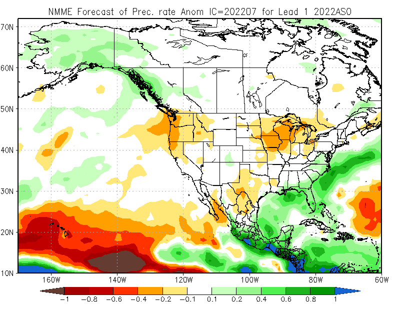
Cpv17 wrote:SoupBone wrote:SFLcane wrote:Wxman57 your call of threats to the NE gulf, Florida , and the caribbean are valid it appears on the NMME.
https://i.postimg.cc/cHwx5QcV/nmme.png
I think his thoughts were based on the persistent and downright hellish death ridge that has been over us in Texas for months now. Of course, patterns can change, but it has definitely been in place for at least two months now, with little signs of budging.
The Euro forecast was showing a favorable look for the NW Gulf a couple days ago for tc activity but the NMME is showing a more favorable look towards the eastern Gulf it appears to me.
NotSparta wrote:SFLcane wrote:Luis....
Caribbean-Florida connection? The entire Florida peninsula is wet on this new NMME .
https://i.postimg.cc/DZf0p76q/FLORIDA.png
Not sure about that. They're kind of disconnected. Would more suggest fronts I'd guess
captainbarbossa19 wrote:Cpv17 wrote:SoupBone wrote:
I think his thoughts were based on the persistent and downright hellish death ridge that has been over us in Texas for months now. Of course, patterns can change, but it has definitely been in place for at least two months now, with little signs of budging.
The Euro forecast was showing a favorable look for the NW Gulf a couple days ago for tc activity but the NMME is showing a more favorable look towards the eastern Gulf it appears to me.
I think it's way too early to speculate on whether or not the NW or NE Gulf will have impacts this season. I remember in 2017 many said the death ridge would protect Texas from anything and then Harvey came. The ridge has not been staying in position all summer either. Yes, it has mainly been situated over the Central Plains, but this weekend it is supposed to shift to the Four Corners, and the GFS was showing it building over the Southeast eventually. All it takes is for one storm to be moving towards the Gulf when the ridge is situated to our east and then the NW Gulf has trouble.

SoupBone wrote:captainbarbossa19 wrote:Cpv17 wrote:
The Euro forecast was showing a favorable look for the NW Gulf a couple days ago for tc activity but the NMME is showing a more favorable look towards the eastern Gulf it appears to me.
I think it's way too early to speculate on whether or not the NW or NE Gulf will have impacts this season. I remember in 2017 many said the death ridge would protect Texas from anything and then Harvey came. The ridge has not been staying in position all summer either. Yes, it has mainly been situated over the Central Plains, but this weekend it is supposed to shift to the Four Corners, and the GFS was showing it building over the Southeast eventually. All it takes is for one storm to be moving towards the Gulf when the ridge is situated to our east and then the NW Gulf has trouble.
I don't recall the placement or duration of the ridge in 2017, but I don't recall a recent year with this firm of a death ridge in place.
HoustonFrog wrote:SoupBone wrote:captainbarbossa19 wrote:
I think it's way too early to speculate on whether or not the NW or NE Gulf will have impacts this season. I remember in 2017 many said the death ridge would protect Texas from anything and then Harvey came. The ridge has not been staying in position all summer either. Yes, it has mainly been situated over the Central Plains, but this weekend it is supposed to shift to the Four Corners, and the GFS was showing it building over the Southeast eventually. All it takes is for one storm to be moving towards the Gulf when the ridge is situated to our east and then the NW Gulf has trouble.
I don't recall the placement or duration of the ridge in 2017, but I don't recall a recent year with this firm of a death ridge in place.
2011?
skyline385 wrote:SFLcane wrote:Luis....
Caribbean-Florida connection? The entire Florida peninsula is wet on this new NMME .
https://i.postimg.cc/DZf0p76q/FLORIDA.png
That precip layout looks kinda similar to what you would see for a Caribbean runner making landfall near W coast FL, also in line with the EURO precip forecasts for August (note how dry the open Atlantic is)
https://uploads.tapatalk-cdn.com/20220707/bc8f9e4a5f79cb5f47f7e48cfd80a47b.jpg
Users browsing this forum: jconsor and 173 guests

