2024 Global Model Runs Discussion (Out thru day 16)
Moderator: S2k Moderators
Forum rules

The posts in this forum are NOT official forecasts and should not be used as such. They are just the opinion of the poster and may or may not be backed by sound meteorological data. They are NOT endorsed by any professional institution or STORM2K. For official information, please refer to products from the National Hurricane Center and National Weather Service.
Re: 2024 Global Model Runs Discussion (Out thru day 16)
12Z EPS: notable uptick in members active with this E Atlantic AEW vs earlier runs.
Last edited by LarryWx on Mon Aug 26, 2024 1:51 pm, edited 2 times in total.
0 likes
Personal Forecast Disclaimer:
The posts in this forum are NOT official forecasts and should not be used as such. They are just the opinion of the poster and may or may not be backed by sound meteorological data. They are NOT endorsed by any professional institution or storm2k.org. For official information, please refer to the NHC and NWS products.
The posts in this forum are NOT official forecasts and should not be used as such. They are just the opinion of the poster and may or may not be backed by sound meteorological data. They are NOT endorsed by any professional institution or storm2k.org. For official information, please refer to the NHC and NWS products.
-
Stratton23
- Category 5

- Posts: 3577
- Joined: Fri Jul 21, 2023 10:59 pm
- Location: Katy, Tx
Re: 2024 Global Model Runs Discussion (Out thru day 16)
I think this might be the system that gets the basin going
4 likes

Re: 2024 Global Model Runs Discussion (Out thru day 16)
So now the missing Euro AIRS is showing up in the main Euro. I wonder if this model is better at predicting longer range, but loses sight in the short--if so, the models will likely need used in conjunction with each other. But the Euro also a history history here, where in the past it would show things at the long range (8-10 days), drop them, around day 8, and then show up again 3-4 days out.
That wave around 240h should be a good indicator of how favorable the Atlantic is in the near term, looks like (if it's real) it should be offshore in a few runs, especially since it seems like it's getting further south and west.
WaveBreaking wrote:TomballEd wrote:SFLcane wrote:12z Euro has a strong TS south of PR..
Lunch break. Do you have an image of 500 mb of that TS? I can't see Euro before my lunch ends.
https://i.imgur.com/D01StKy.jpeg
That wave around 240h should be a good indicator of how favorable the Atlantic is in the near term, looks like (if it's real) it should be offshore in a few runs, especially since it seems like it's getting further south and west.
2 likes
The above post is not official and should not be used as such. It is the opinion of the poster and may or may not be backed by sound meteorological data. It is not endorsed by any professional institution or storm2k.org. For official information, please refer to the NHC and NWS products.
-
'CaneFreak

- Category 5
- Posts: 1487
- Joined: Mon Jun 05, 2006 10:50 am
- Location: New Bern, NC
Re: 2024 Global Model Runs Discussion (Out thru day 16)
AnnularCane wrote:'CaneFreak wrote:Looks like support is growing for at least one tropical development in the area bounded by 10 N 60 W and 10 N and 20 W. That's a wall of ensemble members showing something going on. We should have something to track here within the next week I would imagine. ITCZ has shifted south to 10 N now and things are changing out there quickly.
https://www.tropicaltidbits.com/analysis/models/gfs-ens/2024082612/gfs-ememb_lowlocs_atl_28.png
Where on TT do you go to look at those Spaghetti-O models? Or the regular spaghetti ones? Apparently it's not simply a matter of clicking on Ensembles.
(I like to use the scientific terms.)
Ensembles -> GEFS -> Lower Dynamics -> Ensemble Member MSLP
Last edited by 'CaneFreak on Mon Aug 26, 2024 2:07 pm, edited 1 time in total.
3 likes
-
'CaneFreak
- Category 5
- Posts: 1487
- Joined: Mon Jun 05, 2006 10:50 am
- Location: New Bern, NC
Re: 2024 Global Model Runs Discussion (Out thru day 16)
delete
Last edited by 'CaneFreak on Mon Aug 26, 2024 2:08 pm, edited 1 time in total.
0 likes
-
Stratton23
- Category 5
- Posts: 3577
- Joined: Fri Jul 21, 2023 10:59 pm
- Location: Katy, Tx
Re: 2024 Global Model Runs Discussion (Out thru day 16)
The waves behind the one that the 12z Euro develops are definitely coming off at a lower latitude as well
0 likes
-
skyline385

- Category 5
- Posts: 2728
- Age: 35
- Joined: Wed Aug 26, 2020 11:15 pm
- Location: Houston TX
Re: 2024 Global Model Runs Discussion (Out thru day 16)
Very active 12z GEFS and EPS runs, should see it marked by tomorrow as there are plenty of models developing in 7-day range. Also support on EC HRES and CMC, GFS only one lacking so far but should get onboard soon. GFS, EC HRES and CMC.


Last edited by skyline385 on Mon Aug 26, 2024 2:37 pm, edited 1 time in total.
6 likes
Re: 2024 Global Model Runs Discussion (Out thru day 16)
skyline385 wrote:Very active 12z GEFS and EPS runs, should see it marked by tomorrow as there are plenty of models developing in 7-day range. Also support on EC HRES and CMC, GFS only one lacking so far but should get onboard soon.
https://i.imgur.com/TUFqxCb.png
https://i.imgur.com/0zUvQjp.png
12Z GFS also develops this but not til the far NW Car/SE Gulf ~9/9. But the 12Z UKMET still doesn’t have an actual TCG per the textual output.
0 likes
Personal Forecast Disclaimer:
The posts in this forum are NOT official forecasts and should not be used as such. They are just the opinion of the poster and may or may not be backed by sound meteorological data. They are NOT endorsed by any professional institution or storm2k.org. For official information, please refer to the NHC and NWS products.
The posts in this forum are NOT official forecasts and should not be used as such. They are just the opinion of the poster and may or may not be backed by sound meteorological data. They are NOT endorsed by any professional institution or storm2k.org. For official information, please refer to the NHC and NWS products.
-
skyline385
- Category 5
- Posts: 2728
- Age: 35
- Joined: Wed Aug 26, 2020 11:15 pm
- Location: Houston TX
Re: 2024 Global Model Runs Discussion (Out thru day 16)
LarryWx wrote:skyline385 wrote:Very active 12z GEFS and EPS runs, should see it marked by tomorrow as there are plenty of models developing in 7-day range. Also support on EC HRES and CMC, GFS only one lacking so far but should get onboard soon.
https://i.imgur.com/TUFqxCb.png
https://i.imgur.com/0zUvQjp.png
12Z GFS also develops this but not til the far NW Car/SE Gulf ~9/9. But the 12Z UKMET still doesn’t have an actual TCG per the textual output.
Yea i was just going to post this loop, the system on it is from the same wave and is easily traceable using 700mb plots.

1 likes
-
jlauderdal
- S2K Supporter

- Posts: 7240
- Joined: Wed May 19, 2004 5:46 am
- Location: NE Fort Lauderdale
- Contact:

-
Matlachamullethead
- Tropical Wave

- Posts: 6
- Joined: Sun Mar 10, 2024 5:25 pm
Re: 2024 Global Model Runs Discussion (Out thru day 16)
Scary set up. Some of those stronger members bend back to the west in time.
0 likes
-
Category5Kaiju

- Category 5
- Posts: 4347
- Joined: Thu Dec 24, 2020 12:45 pm
- Location: Seattle during the summer, Phoenix during the winter
Re: 2024 Global Model Runs Discussion (Out thru day 16)
Matlachamullethead wrote:Scary set up. Some of those stronger members bend back to the west in time.
Waaay too early to determine strength/impacts, but if there was anything we learned from Donna, Andrew, and Dorian…..that kind of track is no bueno.
2 likes
Unless explicitly stated, all information in my posts is based on my own opinions and observations. Tropical storms and hurricanes can be extremely dangerous. Refer to an accredited weather research agency or meteorologist if you need to make serious decisions regarding an approaching storm.
Re: 2024 Global Model Runs Discussion (Out thru day 16)
SFLcane wrote:https://i.postimg.cc/vTZZLBQH/hhh.png
Is it me or is that 240h African low ticking further south each run?
2 likes
The above post is not official and should not be used as such. It is the opinion of the poster and may or may not be backed by sound meteorological data. It is not endorsed by any professional institution or storm2k.org. For official information, please refer to the NHC and NWS products.

Re: 2024 Global Model Runs Discussion (Out thru day 16)
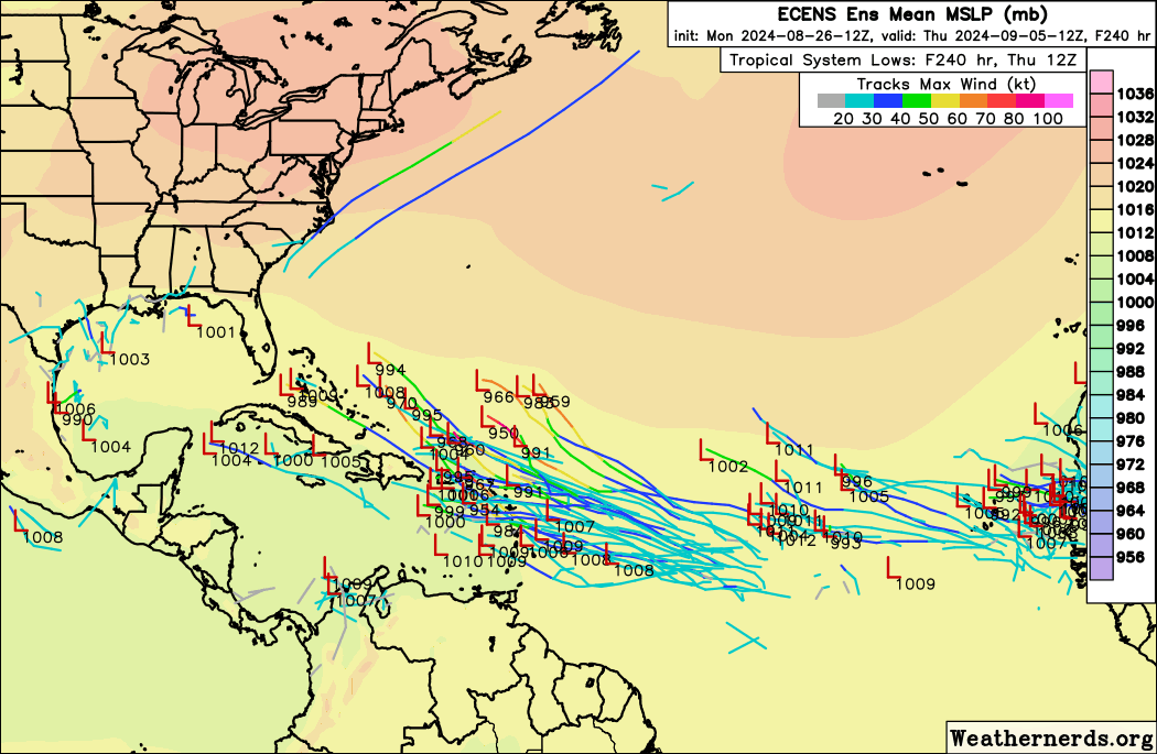
SFLcane wrote:https://i.postimg.cc/vTZZLBQH/hhh.png
I count a whopping 34 lows on this map just from the wave around the Greater Antilles (although not sure if those in Western Caribbean are from a wave further west). That would make it 67% of EPS members showing development, the highest of any ensemble run so far.
3 likes
TC naming lists: retirements and intensity
Most aggressive Advisory #1's in North Atlantic (cr. kevin for starting the list)
Most aggressive Advisory #1's in North Atlantic (cr. kevin for starting the list)
-
DorkyMcDorkface

- Category 5
- Posts: 1044
- Age: 28
- Joined: Mon Sep 30, 2019 1:32 pm
- Location: Mid-Atlantic
Re: 2024 Global Model Runs Discussion (Out thru day 16)
skyline385 wrote:Very active 12z GEFS and EPS runs, should see it marked by tomorrow as there are plenty of models developing in 7-day range. Also support onEC HRES and CMC, GFS only one lacking so far but should get onboard soon.GFS, EC HRES and CMC.
https://i.imgur.com/TUFqxCb.png
https://i.imgur.com/0zUvQjp.png
Definitely starting to look like a map you'd expect to see during peak season
4 likes
Please note the thoughts expressed by this account are solely those of the user and are from a hobbyist perspective. For more comprehensive analysis, consult an actual professional meteorologist or meteorological agency.
Floyd 1999 | Isabel 2003 | Hanna 2008 | Irene 2011 | Sandy 2012 | Isaias 2020
-
TomballEd
- Category 5
- Posts: 1322
- Age: 62
- Joined: Wed Aug 16, 2023 4:52 pm
- Location: Spring/Klein area, not Tomball
Re: 2024 Global Model Runs Discussion (Out thru day 16)
WaveBreaking wrote:TomballEd wrote:SFLcane wrote:12z Euro has a strong TS south of PR..
Lunch break. Do you have an image of 500 mb of that TS? I can't see Euro before my lunch ends.
https://i.imgur.com/D01StKy.jpeg
Verbatim, if that survives Hispaniola and Cuba, that could be a Florida threat. Euro ensembles leaning E of Florida, but there several strong to intense (944mb!) perturbations that don't miss Florida.
2 likes
-
cheezyWXguy

- Category 5
- Posts: 6282
- Joined: Mon Feb 13, 2006 12:29 am
- Location: Dallas, TX
Re: 2024 Global Model Runs Discussion (Out thru day 16)
Welcome to the party, 18z gfs. You’re late.
4 likes
-
Stratton23
- Category 5
- Posts: 3577
- Joined: Fri Jul 21, 2023 10:59 pm
- Location: Katy, Tx
Re: 2024 Global Model Runs Discussion (Out thru day 16)
And just like that the 18z GFS has a much more compact and developing system approaching the antilles islands, i think the models are finally beginning to resolve the monsoon trough issue
2 likes
-
climateconcernnew
- Tropical Low

- Posts: 10
- Joined: Fri Sep 14, 2018 9:19 am
Re: 2024 Global Model Runs Discussion (Out thru day 16)
GFS 18z appears to be a more compact system entering Eastern Caribbean.
1 likes
These are only my personal views or opinions. They are not verified and may cause danger. For your reference please seek official forecast.
Who is online
Users browsing this forum: jconsor and 108 guests