
ENSO Updates (2007 thru 2023)
Moderator: S2k Moderators
Forum rules
The posts in this forum are NOT official forecasts and should not be used as such. They are just the opinion of the poster and may or may not be backed by sound meteorological data. They are NOT endorsed by any professional institution or STORM2K. For official information, please refer to products from the National Hurricane Center and National Weather Service.
- cycloneye
- Admin

- Posts: 149275
- Age: 69
- Joined: Thu Oct 10, 2002 10:54 am
- Location: San Juan, Puerto Rico
Re: Enso Updates=30 day SOI index very positive up to +20.1
Wow,since March 2008, the SOI has not been this high meaning, La Nina continues to expand and getting stronger.


0 likes
Visit the Caribbean-Central America Weather Thread where you can find at first post web cams,radars
and observations from Caribbean basin members Click Here
and observations from Caribbean basin members Click Here
Re: Enso Updates=30 day SOI index very positive up to +20.1
It's looking like it's going to be another horse race, because even with favorable conditions if they all come together just when the polar jet is moving southward then that's that...
We'll see what happens, though I'll guess that per what KWT said might come true - it'll be busier and similar to 2007 (the low tracks this year are very similar to 2007), but not the exceptional season some forecast...
Frank
We'll see what happens, though I'll guess that per what KWT said might come true - it'll be busier and similar to 2007 (the low tracks this year are very similar to 2007), but not the exceptional season some forecast...
Frank
0 likes
Ah but remember Frank this isn't like El Nino, the upper highs are pretty strong and there may not be many breaks in the upper high feature even through towards the end of September, all the breaks we have till then will do is just raise the threat to the US...most tracks will likely aim towards the Caribbean and Florida...we just ened to hope that like 2007 something disrupts them...we got very lucky in 2007 with the TUTT feature, because if you look at some of the systems that died they were aiming for a track like those of 2004...
ps, the La nina is really ramping up, if it gets towards the strong phase, we may well see the hurricane season held back further...
ps, the La nina is really ramping up, if it gets towards the strong phase, we may well see the hurricane season held back further...
0 likes
Personal Forecast Disclaimer:
The posts in this forum are NOT official forecast and should not be used as such. They are just the opinion of the poster and may or may not be backed by sound meteorological data. They are NOT endorsed by any professional institution or storm2k.org. For official information, please refer to the NHC and NWS products
The posts in this forum are NOT official forecast and should not be used as such. They are just the opinion of the poster and may or may not be backed by sound meteorological data. They are NOT endorsed by any professional institution or storm2k.org. For official information, please refer to the NHC and NWS products
- cycloneye
- Admin

- Posts: 149275
- Age: 69
- Joined: Thu Oct 10, 2002 10:54 am
- Location: San Juan, Puerto Rico
Re: Enso Updates
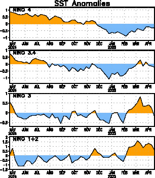
Climate Prediction Center 8/2/10 Weekly Update
La Nina continues to deepen as you can see in the numbers from last week to todays update.
Last Week Numbers
Niño 4= -0.6ºC
Niño 3.4= -1.1ºC
Niño 3= -1.1ºC
Niño1+2= -2.0ºC
This Week Numbers
Niño 4= -0.8ºC
Niño 3.4= -1.3ºC
Niño 3= -1.4ºC
Niño1+2= -1.9ºC
http://www.cpc.ncep.noaa.gov/products/a ... ts-web.pdf

0 likes
Visit the Caribbean-Central America Weather Thread where you can find at first post web cams,radars
and observations from Caribbean basin members Click Here
and observations from Caribbean basin members Click Here
-
StormClouds63
- Category 2

- Posts: 583
- Age: 62
- Joined: Tue May 13, 2008 11:56 am
- Location: Southwest Louisiana
Re:
KWT wrote:Ah but remember Frank this isn't like El Nino, the upper highs are pretty strong and there may not be many breaks in the upper high feature even through towards the end of September, all the breaks we have till then will do is just raise the threat to the US...most tracks will likely aim towards the Caribbean and Florida...we just ened to hope that like 2007 something disrupts them...we got very lucky in 2007 with the TUTT feature, because if you look at some of the systems that died they were aiming for a track like those of 2004...
ps, the La nina is really ramping up, if it gets towards the strong phase, we may well see the hurricane season held back further...
Are you referring to the "peak" of the season, usually noted as September 10? Held back further meaning ... as late as October 1? or a decrease in number of storms?
0 likes
-
StormClouds63
- Category 2

- Posts: 583
- Age: 62
- Joined: Tue May 13, 2008 11:56 am
- Location: Southwest Louisiana
Re: Enso Updates=CPC 8/2/10=Nino 3.4 down to -1.3
I'm a bit of a novice, so I'll ask the question:
What are the effects of a strong LaNina on the tropical Atlantic hurricane season? I'm not sure I'm understanding if it increases or decreases the number and intensity of systems.
What are the effects of a strong LaNina on the tropical Atlantic hurricane season? I'm not sure I'm understanding if it increases or decreases the number and intensity of systems.
0 likes
By that I man perhaps numbers at 14-16NS rather then perhaps the 17-20NS that was banded about pre-season...14-16NS is still on the high side for what most stronger La Ninas get.
Its really complicated, in theory it makes things more favourable but there are alot of added things that complicate the pattern.
Its really complicated, in theory it makes things more favourable but there are alot of added things that complicate the pattern.
0 likes
Personal Forecast Disclaimer:
The posts in this forum are NOT official forecast and should not be used as such. They are just the opinion of the poster and may or may not be backed by sound meteorological data. They are NOT endorsed by any professional institution or storm2k.org. For official information, please refer to the NHC and NWS products
The posts in this forum are NOT official forecast and should not be used as such. They are just the opinion of the poster and may or may not be backed by sound meteorological data. They are NOT endorsed by any professional institution or storm2k.org. For official information, please refer to the NHC and NWS products
-
StormClouds63
- Category 2

- Posts: 583
- Age: 62
- Joined: Tue May 13, 2008 11:56 am
- Location: Southwest Louisiana
Re: Enso Updates=CPC 8/2/10=Nino 3.4 down to -1.3
Thanks, KWT.
Apparently, some neutral years (e.g. 2005) have produced bigger numbers in NS than LaNina seasons. I can see that as with nearly everything else in the tropics, it's complicated. It will be interesting to see how the numbers this season ultimately compare with those of 2007.
Apparently, some neutral years (e.g. 2005) have produced bigger numbers in NS than LaNina seasons. I can see that as with nearly everything else in the tropics, it's complicated. It will be interesting to see how the numbers this season ultimately compare with those of 2007.
0 likes
- cycloneye
- Admin

- Posts: 149275
- Age: 69
- Joined: Thu Oct 10, 2002 10:54 am
- Location: San Juan, Puerto Rico
Re: Enso Updates
Both Climate Prediction Center with -1.3C and the Australians at -1.2C are in the moderate La Nina status. But why the Atlantic season is not behaving like it should having La Nina here?


0 likes
Visit the Caribbean-Central America Weather Thread where you can find at first post web cams,radars
and observations from Caribbean basin members Click Here
and observations from Caribbean basin members Click Here
- cycloneye
- Admin

- Posts: 149275
- Age: 69
- Joined: Thu Oct 10, 2002 10:54 am
- Location: San Juan, Puerto Rico
Re: Enso Updates=CPC monthly bulletin=La Nina getting stronger
Climate Prediction Center Monthly Bulletin
Well,is official now what we knew for the past 3 months would occur. Moderate to strong La Nina is the forecast by CPC until early 2011.
http://www.cpc.ncep.noaa.gov/products/a ... odisc.html
Well,is official now what we knew for the past 3 months would occur. Moderate to strong La Nina is the forecast by CPC until early 2011.
http://www.cpc.ncep.noaa.gov/products/a ... odisc.html
Synopsis: Synopsis: La Niña conditions are expected to strengthen and last through the Northern Hemisphere winter 2010-11.
During July 2010 La Niña conditions developed, as negative sea surface temperature (SST) anomalies strengthened across the central and eastern equatorial Pacific Ocean (Fig. 1). All of the Niño indices decreased with values less than -1.0oC in Niño 1+2, 3, and 3.4 regions at the end of the month (Fig. 2). The subsurface heat content (average temperatures in the upper 300m of the ocean, Fig. 3) continued to reflect a deep layer of below-average temperatures east of the Date Line (Fig. 4). Also convection was enhanced over Indonesia, while remaining suppressed over the western and central tropical Pacific (Fig. 5). Enhanced low-level easterly trade winds and anomalous upper-level westerly winds continued over the western and central equatorial Pacific. Collectively, these oceanic and atmospheric anomalies reflect the development and strengthening of La Niña conditions.
Nearly all models predict La Niña to continue through early 2011 (Fig. 6). However, there is disagreement among the models over the eventual strength of La Niña. Most dynamical models generally predict a moderate-to-strong La Niña, while the majority of the statistical model forecasts indicate a weaker episode. Given the strong cooling observed over the last several months and the apparent ocean-atmosphere coupling (positive feedback), the dynamical model outcome of a moderate-to-strong episode is favored at this time. Therefore, La Niña conditions are expected to strengthen and last through Northern Hemisphere Winter 2010-11.
Expected La Niña impacts during August-October 2010 include suppressed convection over the central tropical Pacific Ocean, and enhanced convection over Indonesia. Temperature and precipitation impacts over the United States are typically weak during the Northern Hemisphere summer and early fall, but strengthen considerably during late fall and winter. Also, La Niña can contribute to increased Atlantic hurricane activity by decreasing the vertical wind shear over the Caribbean Sea and tropical Atlantic Ocean (see the August 5th update of the NOAA Atlantic Seasonal Hurricane Outlook).
0 likes
Visit the Caribbean-Central America Weather Thread where you can find at first post web cams,radars
and observations from Caribbean basin members Click Here
and observations from Caribbean basin members Click Here
- cycloneye
- Admin

- Posts: 149275
- Age: 69
- Joined: Thu Oct 10, 2002 10:54 am
- Location: San Juan, Puerto Rico
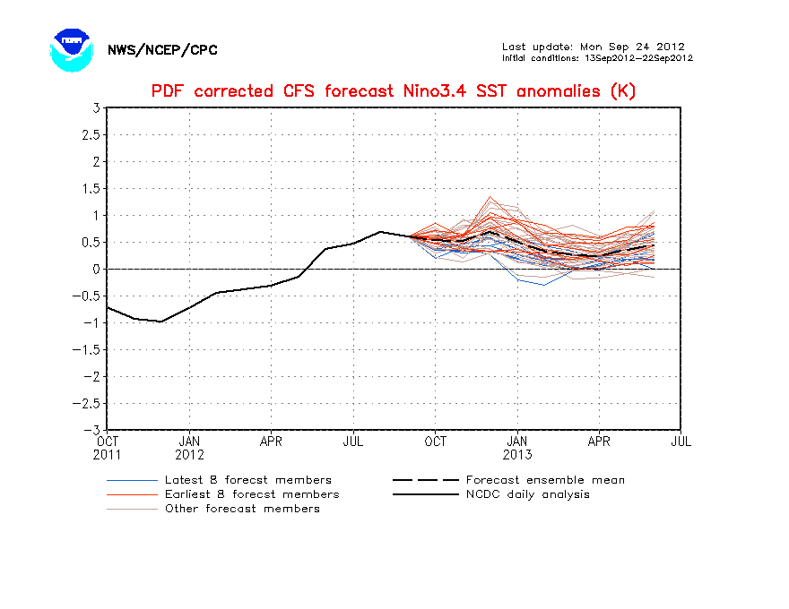
Re: Enso Updates=CPC monthly bulletin=La Nina getting stronger
This La Nina looks to be around for the 2011 Atlantic season.

0 likes
Visit the Caribbean-Central America Weather Thread where you can find at first post web cams,radars
and observations from Caribbean basin members Click Here
and observations from Caribbean basin members Click Here
- Ivanhater
- Storm2k Moderator

- Posts: 11221
- Age: 39
- Joined: Fri Jul 01, 2005 8:25 am
- Location: Pensacola
Re: Enso Updates=CPC monthly bulletin=La Nina getting stronger
Yeah, 2011 looks to be above average as well.
0 likes
Michael
SSt's will likely be much cooler but that will probably be balanced out by more favourable conditions in terms of La Nina, could be something like 1955 or 1999 in terms of the broad pattern, both 2nd year Ninas....but way too early to make that call!
(indeed, SSTs could be close to average in the tropical Atlantic)
(indeed, SSTs could be close to average in the tropical Atlantic)
0 likes
Personal Forecast Disclaimer:
The posts in this forum are NOT official forecast and should not be used as such. They are just the opinion of the poster and may or may not be backed by sound meteorological data. They are NOT endorsed by any professional institution or storm2k.org. For official information, please refer to the NHC and NWS products
The posts in this forum are NOT official forecast and should not be used as such. They are just the opinion of the poster and may or may not be backed by sound meteorological data. They are NOT endorsed by any professional institution or storm2k.org. For official information, please refer to the NHC and NWS products
- Blown Away
- S2K Supporter

- Posts: 10253
- Joined: Wed May 26, 2004 6:17 am
Re: Enso Updates=CPC monthly bulletin=La Nina getting stronger
Where are the -NAO conditions that were forecasted? Very strong Azores high, shear all over MDR, and Bermuda High is supposed to be a little weaker and more SW?
0 likes
Hurricane Eye Experience: David 79, Irene 99, Frances 04, Jeanne 04, Wilma 05… Hurricane Brush Experience: Andrew 92, Erin 95, Floyd 99, Matthew 16, Irma 17, Ian 22, Nicole 22…
La Nina combined with a weakening of the strong -QBO tends to lead to a stronger subtropical High pressure belt...
Thats actually why I think the tropics won't be nearly as warm as they were this summer come this time next year, pattern IMO won't be quite as good next winter for keeping the Atlantic warm.
Thats actually why I think the tropics won't be nearly as warm as they were this summer come this time next year, pattern IMO won't be quite as good next winter for keeping the Atlantic warm.
0 likes
Personal Forecast Disclaimer:
The posts in this forum are NOT official forecast and should not be used as such. They are just the opinion of the poster and may or may not be backed by sound meteorological data. They are NOT endorsed by any professional institution or storm2k.org. For official information, please refer to the NHC and NWS products
The posts in this forum are NOT official forecast and should not be used as such. They are just the opinion of the poster and may or may not be backed by sound meteorological data. They are NOT endorsed by any professional institution or storm2k.org. For official information, please refer to the NHC and NWS products
- cycloneye
- Admin

- Posts: 149275
- Age: 69
- Joined: Thu Oct 10, 2002 10:54 am
- Location: San Juan, Puerto Rico
Re: Enso Updates
Climate Prediction Center Weekly update has Nino 3.4 at -1.1C, actually is up from -1.3C of last week.
Last Week Numbers
Niño 4= -0.8ºC
Niño 3.4= -1.3ºC
Niño 3= -1.4ºC
Niño1+2= -1.9ºC
This Week Numbers
Niño 4= -0.8ºC
Niño 3.4= -1.1ºC
Niño 3= -1.2ºC
Niño1+2= -1.7ºC
http://www.cpc.ncep.noaa.gov/products/a ... ts-web.pdf

Last Week Numbers
Niño 4= -0.8ºC
Niño 3.4= -1.3ºC
Niño 3= -1.4ºC
Niño1+2= -1.9ºC
This Week Numbers
Niño 4= -0.8ºC
Niño 3.4= -1.1ºC
Niño 3= -1.2ºC
Niño1+2= -1.7ºC
http://www.cpc.ncep.noaa.gov/products/a ... ts-web.pdf

0 likes
Visit the Caribbean-Central America Weather Thread where you can find at first post web cams,radars
and observations from Caribbean basin members Click Here
and observations from Caribbean basin members Click Here
- gboudx
- S2K Supporter

- Posts: 4090
- Joined: Thu Sep 04, 2003 1:39 pm
- Location: Rockwall, Tx but from Harvey, La
This is ENSO related regarding a new study on El Ninos. If a new thread is preferred, let me know.
http://www.noaanews.noaa.gov/stories201 ... lnino.html
http://www.noaanews.noaa.gov/stories201 ... lnino.html
NASA/NOAA Study Finds El Niños Growing Stronger
August 25, 2010
A relatively new type of El Niño, which has its warmest waters in the central-equatorial Pacific Ocean, rather than in the eastern-equatorial Pacific, is becoming more common and progressively stronger, according to a new study by NASA and NOAA. The research may improve our understanding of the relationship between El Niños and climate change, and has potential significant implications for long-term weather forecasting.
0 likes
- cycloneye
- Admin

- Posts: 149275
- Age: 69
- Joined: Thu Oct 10, 2002 10:54 am
- Location: San Juan, Puerto Rico
Re: Enso Updates
Australian update at 9/1/10
http://www.bom.gov.au/climate/enso/

http://www.bom.gov.au/climate/enso/
La Niña strengthens in the Pacific
Issued on Wednesday 1 September 2010 | Product Code IDCKGEWWOO
A La Niña event is now well established in the Pacific Ocean. All computer models surveyed by the Bureau suggest Pacific Ocean sea surface temperatures (SSTs) will continue to exceed La Niña thresholds through the southern hemisphere spring, with the majority indicating the event will persist into at least early 2011.
All key indicators of ENSO are at levels typical of a La Niña event. The central Pacific has cooled significantly over the past two weeks, the Southern Oscillation Index (SOI) remains well above La Niña thresholds, cloudiness over the central Pacific remains suppressed and trade winds continue to be stronger than the long-term average in the central and western Pacific.
La Niña periods are usually, but not always, associated with above normal rainfall during the second half of the year across large parts of Australia, most notably eastern and northern regions. Night time temperatures are historically warmer than average and Tropical Cyclone occurrence for northern Australia is typically higher than normal during the cyclone season (November-April).
Recent values of the Indian Ocean Dipole (IOD) index, combined with forecasts from the Bureau’s POAMA model, suggest that a negative IOD event may have commenced in the Indian Ocean. Negative IOD events are often, but not always associated with above average rainfall over large areas of southern Australia during the southern hemisphere spring, and are known to coincide with La Niña events.

0 likes
Visit the Caribbean-Central America Weather Thread where you can find at first post web cams,radars
and observations from Caribbean basin members Click Here
and observations from Caribbean basin members Click Here
- AussieMark
- Category 5

- Posts: 5857
- Joined: Tue Sep 02, 2003 6:36 pm
- Location: near Sydney, Australia
Re: Enso Updates
here is a graph over SOI over the last 6 years
current readings are the highest since 2007/08

current readings are the highest since 2007/08

0 likes
- cycloneye
- Admin

- Posts: 149275
- Age: 69
- Joined: Thu Oct 10, 2002 10:54 am
- Location: San Juan, Puerto Rico
Re: Enso Updates
Climate Prediction Center 9/7/10 Weekly Update
La Nina continues to strenghen,down to -1.6 at area 3.4.
Niño 4=-1.3ºC
Niño 3.4= -1.6ºC
Niño 3= -1.5ºC
Niño1+2= -1.8ºC
http://www.cpc.ncep.noaa.gov/products/a ... ts-web.pdf

La Nina continues to strenghen,down to -1.6 at area 3.4.
Niño 4=-1.3ºC
Niño 3.4= -1.6ºC
Niño 3= -1.5ºC
Niño1+2= -1.8ºC
http://www.cpc.ncep.noaa.gov/products/a ... ts-web.pdf

0 likes
Visit the Caribbean-Central America Weather Thread where you can find at first post web cams,radars
and observations from Caribbean basin members Click Here
and observations from Caribbean basin members Click Here
Who is online
Users browsing this forum: No registered users and 106 guests
