chaser1 wrote:[...] Lastly, I'm a bit leery of the model's suggestion of a sudden large-scale breakdown of the Atlantic 500mb ridge. I'm not seeing any evidence of forecast dip in the progressive higher latitude 500mb flow over the E. CONUS or N. Atlantic. Even if there were a sharpening trough exiting the N.E. Atlantic, it's my thought that a slower to develop tropical system just emerging off the African coast might well remain caught in the lower level trades flow just far enough for ridging to build over the MDR as has been the case for nearly the entire season thus far. Best that I can see, there may be a developing TUTT well east of the E. CONUS in conjunction with a newly eastward building mid to upper level ridge over the U.S. coastline and W. Atlantic. Whether this feature that may develop well E. of the Bahamas plays much or any of roll toward the steering of eventual MDR systems yet to develop, is far from clear cut.
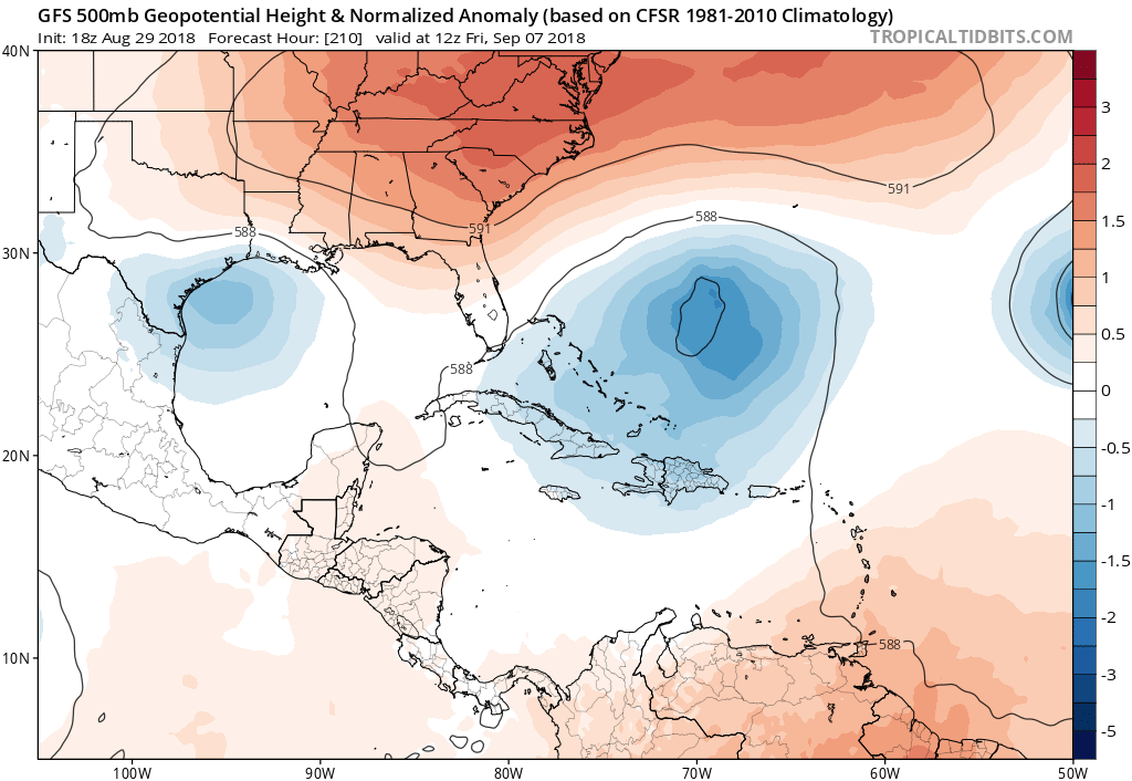
I respectfully disagree. There is actually a robust signal on the 00Z EPS for 1) a gradual northward shift in above-average heights, 2) a retrogressive N-Hemisphere pattern, 3) and a shift in the Pacific pattern, preceding the emergence of a +PNA/-NAO regime. The long-wave evolution portends a gradual emergence of a +PNA (mean ridging) over the West Coast and a downstream trough digging over the Eastern Seaboard. This pattern starts to show up beyond day five on the EPS and becomes quite evident over time, especially by 8 September. At the same time, there are signs of a developing -NAO over the North Atlantic. Combined, the +PNA/-NAO trend would signify northwesterly flow over the western North Atlantic, and while the pattern would be quite conducive to reduced vertical wind shear and low MSLP over the MDR, it would also greatly reduce the risk of a TC threat to the U.S. mainland. Since we have been in a favourable steering pattern for landfalls for several weeks now (just lacking TC activity), and as patterns tend to shift over longer scales of time rather than a handful of days, the upcoming spike in TC activity (early to mid September) looks to coincide with a pattern shift toward a less-favourable large-scale steering regime for U.S. landfalls. This would likely last until late September, and by that time the Cabo Verde season (or at least U.S. threats from that area) begins to wind down climatologically, and then El Niño is likely to shut down the late-season Caribbean/GOM development in late September/October, owing to increasing vertical wind shear in those areas. That means the next two and half weeks are likely going to constitute our hurricane season, and the data presented here suggest that we only have another week before the U.S. threats shut down for 2018. Thus, this upcoming FL/Gulf threat would need to unexpectedly intensify much more than indicated and become a major hurricane to pose a significant U.S. threat, as the pipeline of threats is likely to shut down afterward, owing to the developing East-Coast trough.