2024 Indicators: SST's, MSLP, Shear, SAL, Steering, Instability (Day 16+ Climate Models)
Moderator: S2k Moderators
Forum rules

The posts in this forum are NOT official forecasts and should not be used as such. They are just the opinion of the poster and may or may not be backed by sound meteorological data. They are NOT endorsed by any professional institution or STORM2K. For official information, please refer to products from the National Hurricane Center and National Weather Service.
-
HURRICANELONNY
- Category 5

- Posts: 1390
- Joined: Wed May 07, 2003 6:48 am
- Location: HOLLYWOOD.FL
Re: 2024 Indicators: SST's, MSLP, Shear, SAL, Steering, Instability (Day 16+ Climate Models)
I like reading everyone's posts. Many put alot into research. Everyone has a valid point. July never was busy month in the tropics. Just look at the parabola curve. Shoots up in August. I don't think have 25 names but it gonna be bad year. I'm stocking up now. Prepare for the worst. Hope for the best
7 likes
hurricanelonny
-
jlauderdal
- S2K Supporter

- Posts: 7240
- Joined: Wed May 19, 2004 5:46 am
- Location: NE Fort Lauderdale
- Contact:
Re: 2024 Indicators: SST's, MSLP, Shear, SAL, Steering, Instability (Day 16+ Climate Models)
Wise decision and plan, Oct. is our most active month in Florida so get ready, the setup with the ridge in August looks textbook for landfalling falling hurricanes.HURRICANELONNY wrote:I like reading everyone's posts. Many put alot into research. Everyone has a valid point. July never was busy month in the tropics. Just look at the parabola curve. Shoots up in August. I don't think have 25 names but it gonna be bad year. I'm stocking up now. Prepare for the worst. Hope for the best
0 likes

Re: 2024 Indicators: SST's, MSLP, Shear, SAL, Steering, Instability (Day 16+ Climate Models)
IcyTundra wrote:LarryWx wrote:Whereas season to date ACE is still quite strong due to Beryl, the forecasts with (near) record #s of NS are increasingly looking dicey regarding coming in close. The latest Euro weeklies, which obviously could be off, have well BN Atlantic activity for the next 3 weeks with NN not starting til the week 8/11-18! So, there could very well be just 3 NS through Aug 11.
Highest # of NS 8/11+:
21: 2020, 05
16: 2021, 19, 10, 1969, 50
15: 2023, 1933
Opinions? This isn’t at all a season cancel post but rather a record #NS possible cancel post.
I think this season is going to be more quality over quantity like 2004 and 2017. I think we will see above average activity in the Caribbean during November to somewhat make up for the quiet period right now but not enough to get to the 25 NS forecast from CSU.
That’s what I’ve been thinking too. All 3 systems this year formed in the tropics; we haven’t gotten any higher-latitude slop so far, and the SSTA configuration suggests this’ll be a more tropics-centric year than the last few years. That doesn’t mean we won’t get anything in the subtropics, but it seems like we won’t have a ton of shorties to boost the NS total. So we’ll probably fall a little below the highest NS forecasts with greater ACE per storm than 2018-23.
3 likes
Irene '11 Sandy '12 Hermine '16 5/15/2018 Derecho Fay '20 Isaias '20 Elsa '21 Henri '21 Ida '21
I am only a meteorology enthusiast who knows a decent amount about tropical cyclones. Look to the professional mets, the NHC, or your local weather office for the best information.
I am only a meteorology enthusiast who knows a decent amount about tropical cyclones. Look to the professional mets, the NHC, or your local weather office for the best information.
-
Hypercane_Kyle

- Category 5
- Posts: 3465
- Joined: Sat Mar 07, 2015 7:58 pm
- Location: Cape Canaveral, FL
Re: 2024 Indicators: SST's, MSLP, Shear, SAL, Steering, Instability (Day 16+ Climate Models)
Named storm count is a comparatively meaningless metric to ACE, IMHO.
2017 was a significantly worse hurricane season than 2023, for example, despite the latter having many more named storms.
This season has already produced one high-impact monster. We can expect the lull we're in to continue for another 2-3 weeks, but this season will turn on us on a dime.
2017 was a significantly worse hurricane season than 2023, for example, despite the latter having many more named storms.
This season has already produced one high-impact monster. We can expect the lull we're in to continue for another 2-3 weeks, but this season will turn on us on a dime.
5 likes
My posts are my own personal opinion, defer to the National Hurricane Center (NHC) and other NOAA products for decision making during hurricane season.
-
toad strangler

- S2K Supporter
- Posts: 4546
- Joined: Sun Jul 28, 2013 3:09 pm
- Location: Earth
- Contact:
Re: 2024 Indicators: SST's, MSLP, Shear, SAL, Steering, Instability (Day 16+ Climate Models)
Hypercane_Kyle wrote:Named storm count is a comparatively meaningless metric to ACE, IMHO.
2017 was a significantly worse hurricane season than 2023, for example, despite the latter having many more named storms.
This season has already produced one high-impact monster. We can expect the lull we're in to continue for another 2-3 weeks, but this season will turn on us on a dime.
We’ve all been through this before. The switch flip is nearly immediate when it happens even in less anticipated activity seasons. Hearing Andy Hazelton talk about the basin being a loaded spring is sobering. Like a big ol’ old school rat trap. SNAP
5 likes
My Weather Station
https://www.wunderground.com/dashboard/pws/KFLPORTS603
https://www.wunderground.com/dashboard/pws/KFLPORTS603
-
Category5Kaiju

- Category 5
- Posts: 4330
- Joined: Thu Dec 24, 2020 12:45 pm
- Location: Seattle and Phoenix
Re: 2024 Indicators: SST's, MSLP, Shear, SAL, Steering, Instability (Day 16+ Climate Models)
One thing to look out for is what I call the "alarm clock effect." In other words, models picking up nothing in the long-range for a while, until suddenly, they do mid-range.
Right now the models are quiet and show nothing into early August, but time and time again we've seen how these models also have a tendency to lag in response to a more favorable velocity pattern setting in and wake up roughly a week, if not slightly less, before significant activity picks up again. This has also happened with high-profile storms like Dorian and Fiona, where models showed nothing and then, a week out or so, started showing subtle signals of such storms occurring, which eventually culiminated in full-blown signals (I very much remember the talks of 2019's August ending without a named storm haha).
My point is, stay on the lookout. We know a pattern change is coming soon. The EPAC is sputtering. And with the way this Atlantic season has been behaving and seething with all that warm water, I won't be surprised if the next storm or several storms down ends up being a very powerful, impactful hurricane.
10 likes
Unless explicitly stated, all info in my posts is based on my own opinions and observations. Tropical storms and hurricanes can be extremely dangerous. Refer to an accredited weather research agency or meteorologist if you need to make serious decisions regarding an approaching storm.
-
cycloneye

- Admin

- Posts: 149266
- Age: 69
- Joined: Thu Oct 10, 2002 10:54 am
- Location: San Juan, Puerto Rico
Re: 2024 Indicators: SST's, MSLP, Shear, SAL, Steering, Instability (Day 16+ Climate Models)
3 likes
Visit the Caribbean-Central America Weather Thread where you can find at first post web cams,radars
and observations from Caribbean basin members Click Here
and observations from Caribbean basin members Click Here
-
Pas_Bon
- Tropical Depression

- Posts: 87
- Age: 46
- Joined: Mon Jul 15, 2019 12:25 pm
- Location: League City, TX
Re: 2024 Indicators: SST's, MSLP, Shear, SAL, Steering, Instability (Day 16+ Climate Models)
Category5Kaiju wrote:One thing to look out for is what I call the "alarm clock effect." In other words, models picking up nothing in the long-range for a while, until suddenly, they do mid-range.
Right now the models are quiet and show nothing into early August, but time and time again we've seen how these models also have a tendency to lag in response to a more favorable velocity pattern setting in and wake up roughly a week, if not slightly less, before significant activity picks up again. This has also happened with high-profile storms like Dorian and Fiona, where models showed nothing and then, a week out or so, started showing subtle signals of such storms occurring, which eventually culiminated in full-blown signals (I very much remember the talks of 2019's August ending without a named storm haha).
My point is, stay on the lookout. We know a pattern change is coming soon. The EPAC is sputtering. And with the way this Atlantic season has been behaving and seething with all that warm water, I won't be surprised if the next storm or several storms down ends up being a very powerful, impactful hurricane.
To put it into naval warfare terms....Alberto and Chris were advance/expeditionary light patrol boats. Beryl was a light attack cruiser sent forward to test defenses. She fired a few moderate rounds and surely got our attention with a heavy shot right across our bow.
We've got an entire Armada waiting just beyond the horizon....yet to be seen, but coming.
12 likes
-
cycloneye
- Admin
- Posts: 149266
- Age: 69
- Joined: Thu Oct 10, 2002 10:54 am
- Location: San Juan, Puerto Rico
Re: 2024 Indicators: SST's, MSLP, Shear, SAL, Steering, Instability (Day 16+ Climate Models)
2 likes
Visit the Caribbean-Central America Weather Thread where you can find at first post web cams,radars
and observations from Caribbean basin members Click Here
and observations from Caribbean basin members Click Here
-
Blown Away

- S2K Supporter
- Posts: 10253
- Joined: Wed May 26, 2004 6:17 am
Re: 2024 Indicators: SST's, MSLP, Shear, SAL, Steering, Instability (Day 16+ Climate Models)
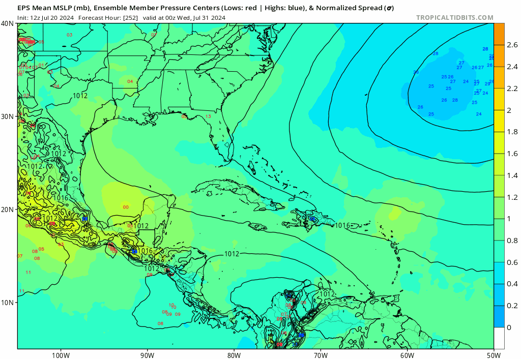
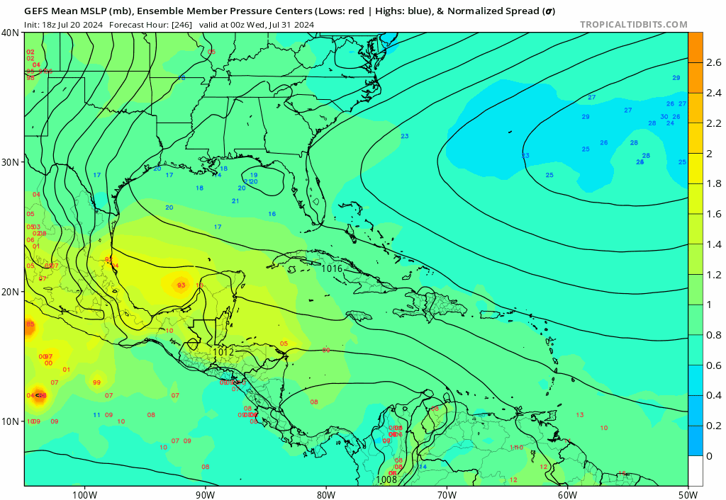
EPS & GEFS starting to sniff something going into August… I think from this point forward the long range models are now in August and will start seeing activity… The Atlantic action is on the doorstep…
2 likes
Hurricane Eye Experience: David 79, Irene 99, Frances 04, Jeanne 04, Wilma 05… Hurricane Brush Experience: Andrew 92, Erin 95, Floyd 99, Matthew 16, Irma 17, Ian 22, Nicole 22…

Re: 2024 Indicators: SST's, MSLP, Shear, SAL, Steering, Instability (Day 16+ Climate Models)
Summer troughs can give you a hint as to future storm tracks. This one came down over Texas. Watch the next one or two as summer progresses and see how far west they come down. A mean axis over the Rockies or west Texas and the west and central Gulf are open. This one indicates more central gulf and points east. And that could matter later in the season when the trough axis start coming down farther east again. But we’ll have to see if any retrograde farther west or if when they come down they stay around the same longitude.
https://www.tropicaltidbits.com/sat/sat ... uct=wv_mid
https://www.tropicaltidbits.com/sat/sat ... uct=wv_mid
3 likes
-
Deshaunrob17
- Tropical Storm

- Posts: 211
- Joined: Tue Aug 18, 2020 7:49 am
Re: 2024 Indicators: SST's, MSLP, Shear, SAL, Steering, Instability (Day 16+ Climate Models)
Can’t believe people are talking about the huge amounts of SAL now and how it could decrease activity. In 2017, we had Sal outbreaks well into the first half of August. It was a major reason why Gert didn’t get going until it reached the suptropics and Harvey struggled east of the Caribbean. Then shear took Harvey out in the Caribbean Sea. However, despite this , 2017 pulled off over 200 AcE. Plus, Beryl got us way ahead of 2017 with AcE.
There were many years when I was iffy with the expectations, but this year I’m probably most confident that when the Atlantic takes off, it will take off in a hurry. It’s a ticking bomb even if it takes us till the 3rd week of August .
There were many years when I was iffy with the expectations, but this year I’m probably most confident that when the Atlantic takes off, it will take off in a hurry. It’s a ticking bomb even if it takes us till the 3rd week of August .
7 likes
-
Category5Kaiju
- Category 5
- Posts: 4330
- Joined: Thu Dec 24, 2020 12:45 pm
- Location: Seattle and Phoenix
Re: 2024 Indicators: SST's, MSLP, Shear, SAL, Steering, Instability (Day 16+ Climate Models)
Deshaunrob17 wrote:Can’t believe people are talking about the huge amounts of SAL now and how it could decrease activity. In 2017, we had Sal outbreaks well into the first half of August. It was a major reason why Gert didn’t get going until it reached the suptropics and Harvey struggled east of the Caribbean. Then shear took Harvey out in the Caribbean Sea. However, despite this , 2017 pulled off over 200 AcE. Plus, Beryl got us way ahead of 2017 with AcE.
There were many years when I was iffy with the expectations, but this year I’m probably most confident that when the Atlantic takes off, it will take off in a hurry. It’s a ticking bomb even if it takes us till the 3rd week of August .
2013 comparisons were strangled before they were born this year, so it's instead now SAL, SAL, SAL
Ok but in all seriousness, while yes SAL is not a positive factor for TCs, I really do think it gets overblown in terms of how detrimental it is for TCs in the Atlantic. I think there's a generic confusion between SAL and mid-level dry air, as they aren't identical phenomena. The latter is much more detrimental for TCs, and as we saw with years like 1983, 2013, and 2022, it can absolutely squash TCs from even forming. If SAL was that bad for TCs, then even years like 2005 and 2017 should've busted dramatically. What we're seeing now is just a classic basin shutdown due to an unfavorable MJO phase with sinking air.
7 likes
Unless explicitly stated, all info in my posts is based on my own opinions and observations. Tropical storms and hurricanes can be extremely dangerous. Refer to an accredited weather research agency or meteorologist if you need to make serious decisions regarding an approaching storm.
-
Deshaunrob17
- Tropical Storm
- Posts: 211
- Joined: Tue Aug 18, 2020 7:49 am
Re: 2024 Indicators: SST's, MSLP, Shear, SAL, Steering, Instability (Day 16+ Climate Models)
Category5Kaiju wrote:Deshaunrob17 wrote:Can’t believe people are talking about the huge amounts of SAL now and how it could decrease activity. In 2017, we had Sal outbreaks well into the first half of August. It was a major reason why Gert didn’t get going until it reached the suptropics and Harvey struggled east of the Caribbean. Then shear took Harvey out in the Caribbean Sea. However, despite this , 2017 pulled off over 200 AcE. Plus, Beryl got us way ahead of 2017 with AcE.
There were many years when I was iffy with the expectations, but this year I’m probably most confident that when the Atlantic takes off, it will take off in a hurry. It’s a ticking bomb even if it takes us till the 3rd week of August .
2013 comparisons were strangled before they were born this year, so it's instead now SAL, SAL, SAL
Ok but in all seriousness, while yes SAL is not a positive factor for TCs, I really do think it gets overblown in terms of how detrimental it is for TCs in the Atlantic. I think there's a generic confusion between SAL and mid-level dry air, as they aren't identical phenomena. The latter is much more detrimental for TCs, and as we saw with years like 1983, 2013, and 2022, it can absolutely squash TCs from even forming. If SAL was that bad for TCs, then even years like 2005 and 2017 should've busted dramatically. What we're seeing now is just a classic basin shutdown due to an unfavorable MJO phase with sinking air.
Also I remember in 2020 there was a lot talk about big Sal outbreaks in June and July is a sign of stronger tropical waves.
And you’re right about Sal being overrated- Beryl is a perfect example. Once a tropical cyclone has a good outflow, Sal gets pushed away from it.
7 likes
-
weeniepatrol

- Category 5
- Posts: 1340
- Joined: Sat Aug 22, 2020 5:30 pm
- Location: WA State
Re: 2024 Indicators: SST's, MSLP, Shear, SAL, Steering, Instability (Day 16+ Climate Models)

Atlantic having almost 3x more ACE than the entire north Pacific combined was not on my bingo card for late July
5 likes


Re: 2024 Indicators: SST's, MSLP, Shear, SAL, Steering, Instability (Day 16+ Climate Models)
Tale as old as time...SAL season cancel posts
Personally SAL has never meant much to me no matter how active it is this time of year. Have seen it thick and widespread across the basin every season for the last 9 years I've tracked the tropics and most of those seasons had plenty of hurricanes come peak season.
Also agree that just because the models look dead now doesn't mean they will by as soon as the end of this week. You just never know and you need to watch conditions real time to get a sense of when the flip switch is coming. I've always been a firm believer in a certain cloud pattern the ITCZ, almost looks like a tail coming off of Africa and extending into the central Atlantic as being a key sign things are about to wake up. Have seen it so many times, saw it with Beryl earlier this year, saw it before things woke up last year, saw it before Bret and Cindy last year, saw it in 2021, 2020 etc.
Another key point...the fact the Atlantic is leading the northern hemisphere ocean basins in ACE is just astonishing. Named storms wise we are only 3 in and behind 2020 by a lot but quality over quantity is how I believe this season is going to play out as well. Number of names storms doesn't mean much imo in regards to how active a season is. ACE takes the cake on that for me personally but just my thought.
To sum up my rambling, I'm still on board with a very active hurricane season ahead, quiet time now is good, because come end of August and September we might be wishing we had it. The SAAL is going to fly, the TUTT's will make their treks across the Atlantic, the shear will perk up at times when surpressed MJO and CCCKW phases pass through, but that's normal.
8 likes
-
WaveBreaking

- Category 2

- Posts: 717
- Joined: Sun Jun 30, 2024 11:33 am
- Location: US
Re: 2024 Indicators: SST's, MSLP, Shear, SAL, Steering, Instability (Day 16+ Climate Models)
Not familiar with July climo, but is the TUTT supposed to be this far north rn?


0 likes
I am NOT a professional meteorologist, so take all of my posts with a grain of salt. My opinions are mine and mine alone.
-
weeniepatrol
- Category 5
- Posts: 1340
- Joined: Sat Aug 22, 2020 5:30 pm
- Location: WA State
Re: 2024 Indicators: SST's, MSLP, Shear, SAL, Steering, Instability (Day 16+ Climate Models)
WaveBreaking wrote:Not familiar with July climo, but is the TUTT supposed to be this far north rn?
https://i.imgur.com/AyuvDva.jpeg
https://i.imgur.com/xjoeJrJ.gif
200mb zonal winds; 1 July to 20 July:
Climatology:

Composite mean:

Anomaly:

Keep in mind the scale. Just realized I missed up and set the upper bound to 30 instead of my intended 20
3 likes
-
WaveBreaking
- Category 2
- Posts: 717
- Joined: Sun Jun 30, 2024 11:33 am
- Location: US
Re: 2024 Indicators: SST's, MSLP, Shear, SAL, Steering, Instability (Day 16+ Climate Models)
weeniepatrol wrote:WaveBreaking wrote:Not familiar with July climo, but is the TUTT supposed to be this far north rn?
https://i.imgur.com/AyuvDva.jpeg
https://i.imgur.com/xjoeJrJ.gif
200mb zonal winds; 1 July to 20 July:
Climatology:
https://i.imgur.com/X6DHejm.png
Composite mean:
https://i.imgur.com/YlLfUFo.png
Anomaly:
https://i.imgur.com/4cC31g9.png
Keep in mind the scale. Just realized I missed up and set the upper bound to 30 instead of my intended 20
Thanks
1 likes
I am NOT a professional meteorologist, so take all of my posts with a grain of salt. My opinions are mine and mine alone.
Re: 2024 Indicators: SST's, MSLP, Shear, SAL, Steering, Instability (Day 16+ Climate Models)
WaveBreaking wrote:weeniepatrol wrote:WaveBreaking wrote:Not familiar with July climo, but is the TUTT supposed to be this far north rn?
https://i.imgur.com/AyuvDva.jpeg
https://i.imgur.com/xjoeJrJ.gif
200mb zonal winds; 1 July to 20 July:
Climatology:
https://i.imgur.com/X6DHejm.png
Composite mean:
https://i.imgur.com/YlLfUFo.png
Anomaly:
https://i.imgur.com/4cC31g9.png
Keep in mind the scale. Just realized I missed up and set the upper bound to 30 instead of my intended 20
Thanks. So it does look like the TUTT is shifted NE of where it should be, which is pretty worrying assuming it stays shifted during peak.
This makes sense actually with how warm the tropical Atlantic is. The warmer water heats the air more, which causes it to thicken, meaning a taller troposphere. Would make sense then that the TUTT's which are upper level lows would be deflected out of the deep tropics due to higher thicknesses over the deep tropics to make a configuration such as the one we are seeing now. This is part of why I think last hurricane season was as active as it was despite a decent strength El Nino.
2 likes
Who is online
Users browsing this forum: Hurricanehink and 86 guests