Weatherfreak000 wrote:KWT wrote:CMC fairly agressive and probably a good deal too far north...yet again.
Its interesting to note, even with Conson in the WPAC, the models went too quickly to the north orginally and therefore we do have a big trend of some models underestimating the upper high.
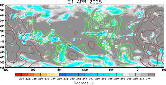
It ALL depends on the location and timing of the circulation of low pressure. There has been no such trend, your falling into an amateurish assumption so early in the season. Take 2005 for example, which had MH Emily and Dennis, the position of the low was instrumental in the path of both systems. People on the East Coast of the GOM as well as Central should be concerned as always especially with the MJO Pulse. There is typically always a moment of weakness in steering currents it becomes nothing more than a game of timing.
.
Whilst I know what your saying I'm pretty confident that nearly all of the storms thus far in the basin have been west of the forecast, not just in the Atlantic but in the other basins, the ECM has been closest thus far this year but thats because the ECM tends to have a better grip on upper high features then the other models.
Remember models do have biases, some modesl like the GFS/GFDL will be more prone to being right of the guidence whilst the ECM/UKMO more prone to the left side. Doesn't always work out like that though of course!
You may well be right though, I'm just talking about what I've observed in Alex, TD2 (though to a lesser extent), 95L was a little bit west of track (though I won't count that one!) TD2E, Blas, Darby and now Conson in the WPAC all tracked west of what the consensus of the models suggested. Of course that could well end tomorrow, who knows!

Anyway ECM not showing alot with this one as others have been saying, the GFS isn't nearly as keen till it gets in the BoC, could well be worth watching there though IMO