2011 WPAC Season

This is the general tropical discussion area. Anyone can take their shot at predicting a storms path.

Moderator: S2k Moderators

Forum rules

The posts in this forum are NOT official forecasts and should not be used as such. They are just the opinion of the poster and may or may not be backed by sound meteorological data. They are NOT endorsed by any professional institution or STORM2K. For official information, please refer to products from the National Hurricane Center and National Weather Service.

Help Support Storm2K
Message
Author
User avatar
cycloneye
Admin
Admin
Posts: 145398
Age: 68
Joined: Thu Oct 10, 2002 10:54 am
Location: San Juan, Puerto Rico

Re: 2011 WPAC Season

#161 Postby cycloneye » Wed Sep 21, 2011 6:08 am

euro6208 wrote:earlier this year, i forecast 2 category 5 landfalls somewhere in the west pacific. i'm starting to think 98W might be one of them. let's wait and watch...


What is your reasoning for 98W?
0 likes   
Visit the Caribbean-Central America Weather Thread where you can find at first post web cams,radars
and observations from Caribbean basin members Click Here

dexterlabio
Category 5
Category 5
Posts: 3470
Joined: Sat Oct 24, 2009 11:50 pm

Re: 2011 WPAC Season

#162 Postby dexterlabio » Wed Sep 21, 2011 7:10 am

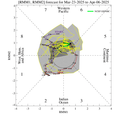
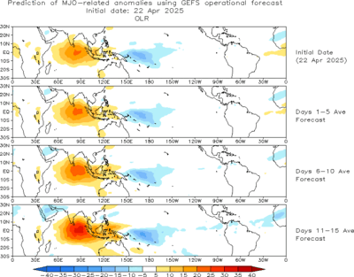
euro6208 wrote:the mjo is currently weak but is showing signs of strengthening as it moves to the east.

this is from cpc:

• There are signs that the MJO may be strengthening. Most dynamical model MJO
index forecasts indicate an eastward propagating MJO signal during the next two
weeks with the enhanced phase shifting across the Maritime continent to the western
Pacific by the end of the period.

• Based on recent observations and model MJO index forecasts, the MJO is forecast to
strengthen during the period.

Image

Image

Image


Thank you for that. The reason why I asked is because of 98W. I'm thinking if we are on the wet phase of MJO, a storm may bring greater amount of rainfall than usual, not necessarily causing intensification in terms of winds. Also, the southwest monsoon still exists and La Nina has returned. So if that's the case, the rain will be the biggest issue here.
0 likes   
Personal Forecast Disclaimer:
The posts in this forum are NOT official forecast and should not be used as such. They are just the opinion of the poster and may or may not be backed by sound meteorological data. They are NOT endorsed by any professional institution or storm2k.org. For official information, please refer to the NHC and NWS products.

euro6208

Re: 2011 WPAC Season

#163 Postby euro6208 » Wed Sep 28, 2011 1:38 am

wow! after nesat which hit luzon, nalgae is forecast to hit extreme northern luzon and NOW ecmwf is showing a 3rd system to form east of the philippines and hit luzon.....triple trouble in store for the philippines! :eek:
0 likes   

User avatar
somethingfunny
ChatStaff
ChatStaff
Posts: 3926
Age: 37
Joined: Thu May 31, 2007 10:30 pm
Location: McKinney, Texas

#164 Postby somethingfunny » Wed Sep 28, 2011 3:04 pm

It's definitely that time of the year for the Phillippines now. :double:
0 likes   
I am not a meteorologist, and any posts made by me are not official forecasts or to be interpreted as being intelligent. These posts are just my opinions and are probably silly opinions.

User avatar
Chacor
Category 5
Category 5
Posts: 10229
Joined: Mon Oct 02, 2006 10:43 pm
Location: Singapore

#165 Postby Chacor » Wed Sep 28, 2011 8:13 pm

With Nalgae, as of today (Sep 29), we are 0.3 storms ahead of the 50-year average.
0 likes   

euro6208

Re: 2011 WPAC Season

#166 Postby euro6208 » Sat Oct 01, 2011 8:30 pm

ecmwf again showing a tropical cyclone formation east of the philippines then making landfall in luzon.. we will see...
0 likes   

Typhoon10
Category 1
Category 1
Posts: 290
Age: 54
Joined: Sat Sep 12, 2009 11:55 pm
Location: Singapore

Re: 2011 WPAC Season

#167 Postby Typhoon10 » Mon Oct 03, 2011 3:27 am

euro6208 wrote:ecmwf again showing a tropical cyclone formation east of the philippines then making landfall in luzon.. we will see...


Yes media here in HK are saying that also, but when I look at ECMWF I dont see anything?

Its been a active couple of weeks and here in HK today, some tasty gusts from the monsoon.
0 likes   

euro6208

Re: 2011 WPAC Season

#168 Postby euro6208 » Wed Oct 05, 2011 2:38 am

wow was i right? before nesat and nalgae, i mention that the philippine sea waters are so warm due to storms forming more north that it has the potential to develop monster typhoons and look what happen...nesat and nalgae!!

the wet phrase of the mjo is slowly moving away from our area and there should be a quiet period that should possibly last until the middle of this month as ecmwf isn't developing anything significant right now. I think the last 2 weeks of october is when those monsters might come back again...alot of time for the waters of the philippine sea to warm up again...
0 likes   

User avatar
Aslkahuna
Professional-Met
Professional-Met
Posts: 4550
Joined: Thu Feb 06, 2003 5:00 pm
Location: Tucson, AZ
Contact:

Re: 2011 WPAC Season

#169 Postby Aslkahuna » Mon Oct 10, 2011 5:15 pm

euro6208 wrote:wow! after nesat which hit luzon, nalgae is forecast to hit extreme northern luzon and NOW ecmwf is showing a 3rd system to form east of the philippines and hit luzon.....triple trouble in store for the philippines! :eek:

In October 1974, we had 5 typhoons and 1 Tropical Storm that hit Luzon during the month-followed a month later by TY Irma the most intense storm at Clark AB since the end of WWII.

Steve
0 likes   

euro6208

Re: 2011 WPAC Season

#170 Postby euro6208 » Wed Oct 12, 2011 4:49 am

euro forecasting yet another very small tropical cyclone to develop to the east of the philippines and making landfall over luzon. we will surely be watching and monitoring this potentially strong system...
0 likes   

User avatar
Chacor
Category 5
Category 5
Posts: 10229
Joined: Mon Oct 02, 2006 10:43 pm
Location: Singapore

#171 Postby Chacor » Wed Oct 12, 2011 7:19 am

We are at 20 storms now, 0.5 behind the 50-year average. However, we are on pace for 25.7 storms this year (Banyan named on the 284th day of the year; 20/(284/365) ≈ 25.7).

If we get to 25 named storms, it would be our most active year since 2004 (29 storms).
0 likes   

dwsqos2

Re: 2011 WPAC Season

#172 Postby dwsqos2 » Wed Oct 12, 2011 7:56 am

With such glorious named storms as Haiting and Tokage, using named systems as a metric of seasonal activity is a bad idea. Actually Banyan hasn't been much better given that it has had such a poorly defined low-level circulation for much of its exsitence.

Looking at Ryan Maue's site, current WPAC ACE sits at 203.14; the to-date climatological mean is 216. The WPAC is running below average. It joins every other basin in the world with a pathetic season.
0 likes   

euro6208

Re: 2011 WPAC Season

#173 Postby euro6208 » Thu Oct 13, 2011 3:44 am

NORMAL YEARLY ACE** NORMAL YEAR TO DATE


Northern Hemisphere 556 441

Western North Pacific 304 218

we are still behind this year...
0 likes   

User avatar
Chacor
Category 5
Category 5
Posts: 10229
Joined: Mon Oct 02, 2006 10:43 pm
Location: Singapore

#174 Postby Chacor » Thu Oct 13, 2011 6:00 am

Be careful with ACE figures though, many sites out there use JTWC data for ACE.
0 likes   

dexterlabio
Category 5
Category 5
Posts: 3470
Joined: Sat Oct 24, 2009 11:50 pm

Re: 2011 WPAC Season

#175 Postby dexterlabio » Thu Oct 13, 2011 10:21 am

2004 is the most active season I witnessed in my life. Followed by 2006. If I am to compare 2011 with the previous seasons starting from 1991, so far, I have to agree that it is running quite below average, but it can't be denied that this season is more active than 2008-2010 seasons (maybe tied with 2009). I still can't conclude because we have until November to see if it is going to cope up and end with a bang. :roll:


IMO, be it statistically below average, the areas hit by the consecutive tropical cyclones this year don't feel that way.
0 likes   
Personal Forecast Disclaimer:
The posts in this forum are NOT official forecast and should not be used as such. They are just the opinion of the poster and may or may not be backed by sound meteorological data. They are NOT endorsed by any professional institution or storm2k.org. For official information, please refer to the NHC and NWS products.

dexterlabio
Category 5
Category 5
Posts: 3470
Joined: Sat Oct 24, 2009 11:50 pm

Re: 2011 WPAC Season

#176 Postby dexterlabio » Thu Oct 13, 2011 10:31 am

dwsqos2 wrote:With such glorious named storms as Haiting and Tokage, using named systems as a metric of seasonal activity is a bad idea. Actually Banyan hasn't been much better given that it has had such a poorly defined low-level circulation for much of its exsitence.

Looking at Ryan Maue's site, current WPAC ACE sits at 203.14; the to-date climatological mean is 216. The WPAC is running below average. It joins every other basin in the world with a pathetic season.


I think the ATL basin takes the cake. lol. Irene and Ophelia are the only interesting systems that formed there. In a way, the WPAC this year has already spawned impressive systems from Songda to Muifa to Nanmadol and lately, Nalgae.
0 likes   
Personal Forecast Disclaimer:
The posts in this forum are NOT official forecast and should not be used as such. They are just the opinion of the poster and may or may not be backed by sound meteorological data. They are NOT endorsed by any professional institution or storm2k.org. For official information, please refer to the NHC and NWS products.

euro6208

Re: 2011 WPAC Season

#177 Postby euro6208 » Thu Oct 13, 2011 10:10 pm

at this time last year, we were on our 15th tropical cyclone (compared to 23 this year) in a very slow season. that system turned out to become a monster typhoon with records shattered. Super Typhoon Megi. 170 to 175 knots 1 minute sustained winds measured by recon! which would give Megi the record with the Highest sustained wind speed of any tropical cyclone anywhere in the world...


Image

Image


Later on, Megi made landfall over luzon

Image

with a central pressure of 885 mb, if official, will be the strongest tropical cyclone at landfall anywhere in the world...
0 likes   

User avatar
StormingB81
S2K Supporter
S2K Supporter
Posts: 5676
Age: 43
Joined: Thu Aug 27, 2009 1:45 am
Location: Rockledge, Florida

Re: 2011 WPAC Season

#178 Postby StormingB81 » Thu Oct 13, 2011 10:26 pm

dwsqos2 wrote:With such glorious named storms as Haiting and Tokage, using named systems as a metric of seasonal activity is a bad idea. Actually Banyan hasn't been much better given that it has had such a poorly defined low-level circulation for much of its exsitence.

Looking at Ryan Maue's site, current WPAC ACE sits at 203.14; the to-date climatological mean is 216. The WPAC is running below average. It joins every other basin in the world with a pathetic season.


I wouldn;t say it was pathetic...Okinawa was hit hard by multible storms early in the eyar and as of late PI has been getting hit hard...I doubt we would say it was pathetic...Remember with Mafia we had over 40 Inches of rain in less the 2 days
0 likes   

User avatar
Chacor
Category 5
Category 5
Posts: 10229
Joined: Mon Oct 02, 2006 10:43 pm
Location: Singapore

Re: 2011 WPAC Season

#179 Postby Chacor » Fri Oct 14, 2011 6:14 am

euro6208 wrote:at this time last year, we were on our 15th tropical cyclone

No, we weren't, because the JTWC isn't official.
0 likes   

euro6208

Re: 2011 WPAC Season

#180 Postby euro6208 » Fri Oct 14, 2011 7:14 am

Chacor wrote:
euro6208 wrote:at this time last year, we were on our 15th tropical cyclone

No, we weren't, because the JTWC isn't official.


yeah i know that but JTWC uses 1 minute classification just like NHC and thats all that matters...
0 likes   


Return to “Talkin' Tropics”

Who is online

Users browsing this forum: cheezyWXguy, Google Adsense [Bot] and 40 guests