2015 Global model runs discussion
Moderator: S2k Moderators
Forum rules
The posts in this forum are NOT official forecasts and should not be used as such. They are just the opinion of the poster and may or may not be backed by sound meteorological data. They are NOT endorsed by any professional institution or STORM2K. For official information, please refer to products from the National Hurricane Center and National Weather Service.
- gatorcane
- S2K Supporter

- Posts: 23708
- Age: 48
- Joined: Sun Mar 13, 2005 3:54 pm
- Location: Boca Raton, FL
Maybe MiamiensisWx. I have noticed the GFS has shown some impulses moving west under the Bermuda High in the long-range. I wouldn't be surprised if we see nothing until late Aug. but then see some good activity in September and October. Area just north of the Caribbean could be the place to watch. Also will probably get a couple way out in the Central Atlantic that ultimately recurve
0 likes
- crownweather
- S2K Supporter

- Posts: 602
- Age: 51
- Joined: Sat Aug 12, 2006 9:21 am
- Location: Sturbridge, Massachusetts
- Contact:
Re: 2015 Global model runs discussion
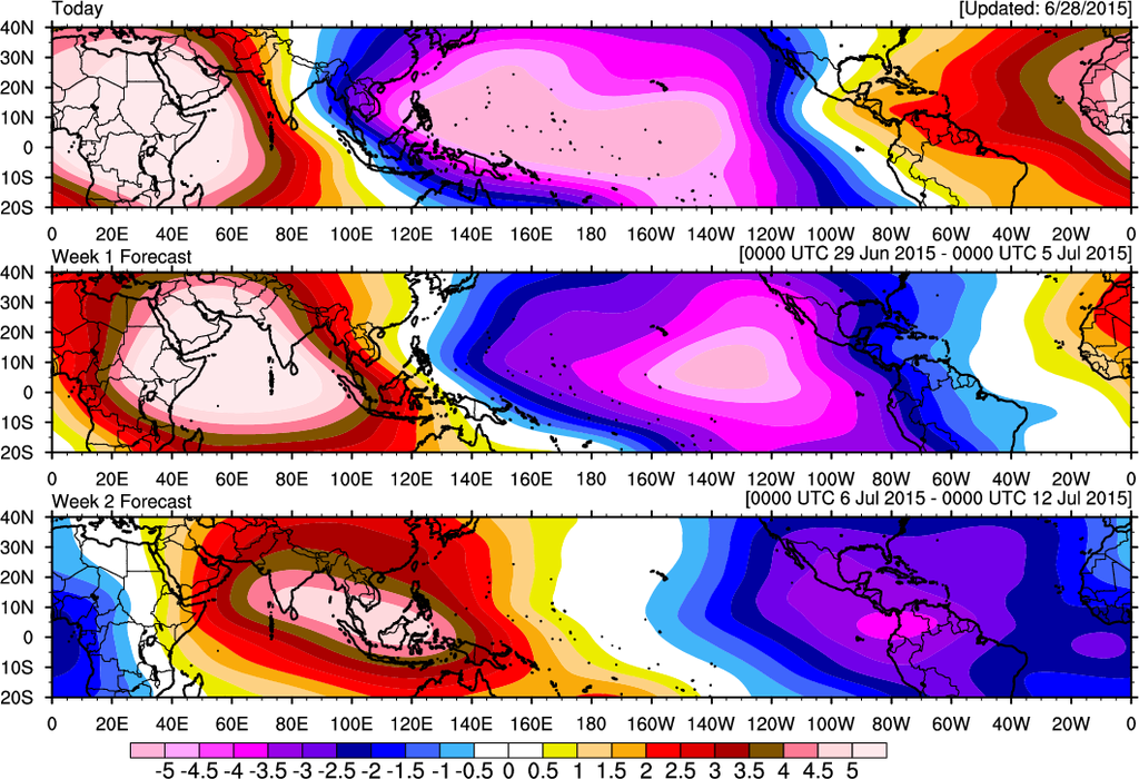
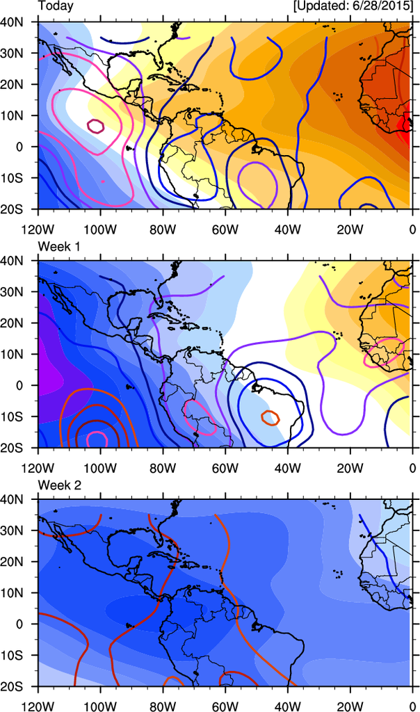
That early-mid July time frame is definitely on my "radar" as well as it appears that the upward motion pulse of the MJO should arrive in the Atlantic by then. Also, the extremely long range Japanese model does seem to subtly "hint" at in close development in about 3 to 4 weeks from now with lowering pressures along the US East Coast and maybe some sort of a trof split. I'm leaning more towards mid July rather than early July to really watch for this possible development.


0 likes
Rob Lightbown
Crown Weather Services
https://crownweather.com
Crown Weather Services
https://crownweather.com
- northjaxpro
- S2K Supporter

- Posts: 8900
- Joined: Mon Sep 27, 2010 11:21 am
- Location: Jacksonville, FL
Yeah, it is expected that there will be a spike with the MJO in the SW Atlantic/NW Caribbean to the GOM. Lower pressures may occur in these regions during the first week of July. Maybe a possible homegrown entity. It will be interesting if the EURO will continue to show something in future model runs, as well if GFS and the other models jump onboard. But, yes, things potentially could get interesting over the next 7-10 days.
0 likes
NEVER, EVER SAY NEVER in the tropics and weather in general, and most importantly, with life itself!!
________________________________________________________________________________________
Fay 2008 Beryl 2012 Debby 2012 Colin 2016 Hermine 2016 Julia 2016 Matthew 2016 Irma 2017 Dorian 2019
________________________________________________________________________________________
Fay 2008 Beryl 2012 Debby 2012 Colin 2016 Hermine 2016 Julia 2016 Matthew 2016 Irma 2017 Dorian 2019
- srainhoutx
- S2K Supporter

- Posts: 6919
- Age: 68
- Joined: Sun Jan 14, 2007 11:34 am
- Location: Haywood County, NC
- Contact:
Re: 2015 Global model runs discussion
Keep an eye on the Southern Gulf around mid July for potential tropical development. A robust MJO pulse and a very healthy CCKW is expected to arrive across the Eastern Pacific in early July and push E into the Western Atlantic Basin.


0 likes
Carla/Alicia/Jerry(In The Eye)/Michelle/Charley/Ivan/Dennis/Katrina/Rita/Wilma/Ike/Harvey
Member: National Weather Association
Wx Infinity Forums
http://wxinfinity.com/index.php
Facebook.com/WeatherInfinity
Twitter @WeatherInfinity
Member: National Weather Association
Wx Infinity Forums
http://wxinfinity.com/index.php
Facebook.com/WeatherInfinity
Twitter @WeatherInfinity
- Yellow Evan
- Professional-Met

- Posts: 16240
- Age: 27
- Joined: Fri Jul 15, 2011 12:48 pm
- Location: Henderson, Nevada/Honolulu, HI
- Contact:
One problem with the above. None of the models actually bring MJO past phase 7 in the next two weeks.
Look here: http://www.cpc.ncep.noaa.gov/products/p ... r_wh.shtml
Look here: http://www.cpc.ncep.noaa.gov/products/p ... r_wh.shtml
0 likes
- gatorcane
- S2K Supporter

- Posts: 23708
- Age: 48
- Joined: Sun Mar 13, 2005 3:54 pm
- Location: Boca Raton, FL
So the global models continue to be quiet for the Atlantic for the next week at least and even beyond that with nothing showing up on the GFS for the next 16 days.
But one area that may be worth watching for development down the road is a tropical wave (though development chances look quite low given no model support) that should be exiting the coast of Africa in the next 2-3 days. The latest GFS 18Z run shows this wave traversing the MDR and then heading WNW to NW east of the Leewards and eventually ending up in the area just north of the Puerto Rico by day 10.
So if it can survive the hostile MDR, it may just have an opportunity if it makes it north of the Caribbean where conditions look more favorable.
You can see on this floater about ready to exit the African coast. Image loop shows a pretty broad circulation already present with this wave:
http://rammb.cira.colostate.edu/ramsdis ... display=24

18Z GFS shows it just east of Northern Leewards by day 7:

18Z GFS shows it just north of Puerto Rico by day 10:

But one area that may be worth watching for development down the road is a tropical wave (though development chances look quite low given no model support) that should be exiting the coast of Africa in the next 2-3 days. The latest GFS 18Z run shows this wave traversing the MDR and then heading WNW to NW east of the Leewards and eventually ending up in the area just north of the Puerto Rico by day 10.
So if it can survive the hostile MDR, it may just have an opportunity if it makes it north of the Caribbean where conditions look more favorable.
You can see on this floater about ready to exit the African coast. Image loop shows a pretty broad circulation already present with this wave:
http://rammb.cira.colostate.edu/ramsdis ... display=24

18Z GFS shows it just east of Northern Leewards by day 7:

18Z GFS shows it just north of Puerto Rico by day 10:

0 likes
- gatorcane
- S2K Supporter

- Posts: 23708
- Age: 48
- Joined: Sun Mar 13, 2005 3:54 pm
- Location: Boca Raton, FL
GFS shows a big TUTT low centered near Eastern Cuba a week from now. A TUTT in that location is pretty typical for early July so nothing unusual. That TUTT low will generate a lot of wind shear that basically should prevent anything from developing in the Caribbean, Bahamas, or SW Atlantic for the next 7-10 days.

The posts in this forum are NOT official forecast and should not be used as such. They are just the opinion of the poster and may or may not be backed by sound meteorological data. They are NOT endorsed by any professional institution or storm2k.org. For official information, please refer to the NHC and NWS products.

The posts in this forum are NOT official forecast and should not be used as such. They are just the opinion of the poster and may or may not be backed by sound meteorological data. They are NOT endorsed by any professional institution or storm2k.org. For official information, please refer to the NHC and NWS products.
0 likes
- crownweather
- S2K Supporter

- Posts: 602
- Age: 51
- Joined: Sat Aug 12, 2006 9:21 am
- Location: Sturbridge, Massachusetts
- Contact:
Re: 2015 Global model runs discussion
Beyond that, I'm still eyeing the period around July 15th when we could see some sort of in close development. GFS model, FWIW, has been somewhat consistent in showing a trof split during the 300-384 hr period which leads to low pressure moving into the northeast GOM underneath an area of low shear. At this point, it's at the entertainment part of the model run, but it is something to at least ponder.


0 likes
Rob Lightbown
Crown Weather Services
https://crownweather.com
Crown Weather Services
https://crownweather.com
Re:
Yellow Evan wrote:One problem with the above. None of the models actually bring MJO past phase 7 in the next two weeks.
Look here: http://www.cpc.ncep.noaa.gov/products/p ... r_wh.shtml
The image Gatorcane posted is from August 17th, it is in Euro date format.
0 likes
The following post is NOT an official forecast and should not be used as such. It is just the opinion of the poster and may or may not be backed by sound meteorological data. It is NOT endorsed by any professional institution including storm2k.org For Official Information please refer to the NHC and NWS products.
-
lovingseason2013
- Tropical Depression

- Posts: 71
- Joined: Sat Oct 12, 2013 7:54 am
- Location: Pensacola, FL
Re: 2015 Global model runs discussion
I just hope South Florida can get some rain, did you know they are having a drought down there?
0 likes
-
floridasun78
- Category 5

- Posts: 3755
- Joined: Sun May 17, 2009 10:16 pm
- Location: miami fl
Re: 2015 Global model runs discussion
miami weather office say we could see tropical wave by south fl by weekend that by of middle of Atlantic
0 likes
Re:
gatorcane wrote:So the global models continue to be quiet for the Atlantic for the next week at least and even beyond that with nothing showing up on the GFS for the next 16 days.
But one area that may be worth watching for development down the road is a tropical wave (though development chances look quite low given no model support) that should be exiting the coast of Africa in the next 2-3 days. The latest GFS 18Z run shows this wave traversing the MDR and then heading WNW to NW east of the Leewards and eventually ending up in the area just north of the Puerto Rico by day 10.
So if it can survive the hostile MDR, it may just have an opportunity if it makes it north of the Caribbean where conditions look more favorable.
Curiously, both the EURO and GFS 500mb forecast from this morning's 12Z run, show a mid level vorticity north of Dominican Republic and slowly moving westward with time. This begins to show up around 210 hours and the mid level low eventually moves over the Florida Straits, shunted SW, and then into the South Central Gulf moving NW. I'm guessing that this is the Northeastern extension of that prior mentioned tropical wave. Depending on upper level conditions, I think this could be a feature of interest. The key of course is tied to whether their might be a short term transition from volatile upper level conditions to somewhat more neutral (yet difluent) upper air conditions. Neither model yet depicts any lower surface pressures with this feature as of this a.m.
As a side note, its rather odd that given that both global models depict this feature approaching from the east at nearly the same time, the EURO indicates a sharp digging 500mb trough in the Northern Plains at this time, while the GFS is entirely contrary and showing big ridging in the N. Central US, but with a mid level trough digging down the Eastern Seaboard (fitting in with the more typical predominant "east coast trough regime").
0 likes
Andy D
(For official information, please refer to the NHC and NWS products.)
(For official information, please refer to the NHC and NWS products.)
Re: 2015 Global model runs discussion
lovingseason2013 wrote:I just hope South Florida can get some rain, did you know they are having a drought down there?

0 likes
Andy D
(For official information, please refer to the NHC and NWS products.)
(For official information, please refer to the NHC and NWS products.)
Re: 2015 Global model runs discussion
crownweather wrote:Beyond that, I'm still eyeing the period around July 15th when we could see some sort of in close development. GFS model, FWIW, has been somewhat consistent in showing a trof split during the 300-384 hr period which leads to low pressure moving into the northeast GOM underneath an area of low shear. At this point, it's at the entertainment part of the model run, but it is something to at least ponder.
Looked to me like this a.m.'s GFS run is still trying to develop a low in the NW Caribbean; might this coincide with the MJO finally shifting eastward and into the extreme W. Atlantic region by this time?
0 likes
Andy D
(For official information, please refer to the NHC and NWS products.)
(For official information, please refer to the NHC and NWS products.)
- gatorcane
- S2K Supporter

- Posts: 23708
- Age: 48
- Joined: Sun Mar 13, 2005 3:54 pm
- Location: Boca Raton, FL
Both the ECMWF and GFS models are showing a very impressive wave moving off Africa by this time next week. Latest GFS run closes off a low and moves this low west at a very low latitude in the MDR in the long-range where the low holds together with even some slow development.
I took a look at the latest vis SAT loop over Africa and I see exactly what these models are picking up on. The wave is very impressive with cyclonic turning already noticeable.
Africa sat loop:
http://rammb.cira.colostate.edu/ramsdis ... display=24


I took a look at the latest vis SAT loop over Africa and I see exactly what these models are picking up on. The wave is very impressive with cyclonic turning already noticeable.
Africa sat loop:
http://rammb.cira.colostate.edu/ramsdis ... display=24


0 likes
- cycloneye
- Admin

- Posts: 149507
- Age: 69
- Joined: Thu Oct 10, 2002 10:54 am
- Location: San Juan, Puerto Rico
Re: 2015 Global model runs discussion
Mid July seems like a good period to watch as Rob has mentioned and now the pros confirm.
Eric Blake @EricBlake12 · 8m8 minutes ago
Long-range fcsts finally showing the Atlantic ridge weakening-- Will be watching subtropics for TC activity mid-July
Eric Blake @EricBlake12 · 8m8 minutes ago
Long-range fcsts finally showing the Atlantic ridge weakening-- Will be watching subtropics for TC activity mid-July
0 likes
Visit the Caribbean-Central America Weather Thread where you can find at first post web cams,radars
and observations from Caribbean basin members Click Here
and observations from Caribbean basin members Click Here
- Andrew92
- S2K Supporter

- Posts: 3247
- Age: 42
- Joined: Mon Jun 16, 2003 12:35 am
- Location: Phoenix, Arizona
Re: 2015 Global model runs discussion
cycloneye wrote:Mid July seems like a good period to watch as Rob has mentioned and now the pros confirm.
Eric Blake @EricBlake12 · 8m8 minutes ago
Long-range fcsts finally showing the Atlantic ridge weakening-- Will be watching subtropics for TC activity mid-July
Mid-July in the subtropics, in this active period since 1995, has been quite favorable for tropical storm development in traditional El Nino years. We had Bill and Claudette in 1997, Arthur in 2002, and an unnamed storm and Beryl in 2006. Only Bill (briefly) became a hurricane though, and none of these storms lasted particularly long.
Not saying it will happen this year, as it didn't happen in 2009, but stay tuned....
-Andrew92
0 likes
Who is online
Users browsing this forum: No registered users and 163 guests


