Low Pressure in the Central Atlantic (Is Invest 91L)
Moderator: S2k Moderators
Forum rules

The posts in this forum are NOT official forecasts and should not be used as such. They are just the opinion of the poster and may or may not be backed by sound meteorological data. They are NOT endorsed by any professional institution or STORM2K. For official information, please refer to products from the National Hurricane Center and National Weather Service.

Re: Tropical Wave SW of the Cabo Verde Islands
We only need 6 more days, this thing needs to hold off! 
0 likes
Personal Forecast Disclaimer:
The posts in this forum are NOT official forecast and should not be used as such. They are just the opinion of the poster and may or may not be backed by sound meteorological data. They are NOT endorsed by any professional institution or storm2k.org. For official information, please refer to the NHC and NWS products.
The posts in this forum are NOT official forecast and should not be used as such. They are just the opinion of the poster and may or may not be backed by sound meteorological data. They are NOT endorsed by any professional institution or storm2k.org. For official information, please refer to the NHC and NWS products.
-
tropicwatch

- Category 5

- Posts: 3426
- Age: 62
- Joined: Sat Jun 02, 2007 10:01 am
- Location: The Villages, Florida
- Contact:
Re: Tropical Wave SW of the Cabo Verde Islands
There has been a significant increase in 925mb vorticity this morning. Yesterday it was almost non-existent.

0 likes
Tropicwatch
Agnes 72', Eloise 75, Elena 85', Kate 85', Charley 86', Florence 88', Beryl 94', Dean 95', Erin 95', Opal 95', Earl 98', Georges 98', Ivan 2004', Arlene 2005', Dennis 2005', Ida 2009' Debby 2012' Irma 2017' Michael 2018'
Agnes 72', Eloise 75, Elena 85', Kate 85', Charley 86', Florence 88', Beryl 94', Dean 95', Erin 95', Opal 95', Earl 98', Georges 98', Ivan 2004', Arlene 2005', Dennis 2005', Ida 2009' Debby 2012' Irma 2017' Michael 2018'
-
Iceresistance

- Category 5
- Posts: 9599
- Age: 22
- Joined: Sat Oct 10, 2020 9:45 am
- Location: Tecumseh, OK/Norman, OK
Re: Tropical Wave SW of the Cabo Verde Islands
1 likes
Bill 2015 & Beta 2020
Winter 2020-2021
All observations are in Tecumseh, OK unless otherwise noted.
Winter posts are focused mainly for Oklahoma & Texas.
Take any of my forecasts with a grain of salt, refer to the NWS, SPC, and NHC for official information
Never say Never with weather! Because ANYTHING is possible!
Winter 2020-2021
All observations are in Tecumseh, OK unless otherwise noted.
Winter posts are focused mainly for Oklahoma & Texas.
Take any of my forecasts with a grain of salt, refer to the NWS, SPC, and NHC for official information
Never say Never with weather! Because ANYTHING is possible!
-
USTropics
- Professional-Met

- Posts: 2739
- Joined: Sun Aug 12, 2007 3:45 am
- Location: Florida State University
Re: Tropical Wave SW of the Cabo Verde Islands
It's pretty simple, NHC is tracking the axis of the trailing wave. The mid-level surge from the trailing wave will pivot this complex north later today. My post from last night outlines this: https://www.storm2k.org/phpbb2/viewtopi ... 9#p2982319
Latest ECMWF (06z) shows this evolution as well:

3 likes
Re: Tropical Wave SW of the Cabo Verde Islands
USTropics wrote:
It's pretty simple, NHC is tracking the axis of the trailing wave. The mid-level surge from the trailing wave will pivot this complex north later today. My post from last night outlines this: https://www.storm2k.org/phpbb2/viewtopi ... 9#p2982319
Latest ECMWF (06z) shows this evolution as well:
https://i.ibb.co/8Xd2Gvt/ecmwf-z850-vort-atl-fh0-90.gif
I don't disagree with that at all, but I do think it's ahead of schedule and the 8am two is a bit too conservative with 30%.
0 likes
-
Iceresistance
- Category 5
- Posts: 9599
- Age: 22
- Joined: Sat Oct 10, 2020 9:45 am
- Location: Tecumseh, OK/Norman, OK
Re: Tropical Wave SW of the Cabo Verde Islands
Visible is showing a squall that has been ejected to the SE.

https://s4.gifyu.com/images/30789505.gif
https://s4.gifyu.com/images/30789505.gif
0 likes
Bill 2015 & Beta 2020
Winter 2020-2021
All observations are in Tecumseh, OK unless otherwise noted.
Winter posts are focused mainly for Oklahoma & Texas.
Take any of my forecasts with a grain of salt, refer to the NWS, SPC, and NHC for official information
Never say Never with weather! Because ANYTHING is possible!
Winter 2020-2021
All observations are in Tecumseh, OK unless otherwise noted.
Winter posts are focused mainly for Oklahoma & Texas.
Take any of my forecasts with a grain of salt, refer to the NWS, SPC, and NHC for official information
Never say Never with weather! Because ANYTHING is possible!
-
AutoPenalti
- Category 5
- Posts: 4091
- Age: 29
- Joined: Mon Aug 17, 2015 4:16 pm
- Location: Ft. Lauderdale, Florida
Re: Tropical Wave SW of the Cabo Verde Islands
Iceresistance wrote:Visible is showing a squall that has been ejected to the SE.
https://s4.gifyu.com/images/30789505.gif
https://s4.gifyu.com/images/30789505.gif
Looks like it's puking outflow boundaries, it's crazy to think how dry the ATL is...
1 likes
The posts in this forum are NOT official forecasts and should not be used as such. They are just the opinion of the poster and may or may not be backed by sound meteorological data. They are NOT endorsed by any professional institution or STORM2K. For official information, please refer to products from the NHC and NWS.
Model Runs Cheat Sheet:
GFS (5:30 AM/PM, 11:30 AM/PM)
HWRF, GFDL, UKMET, NAVGEM (6:30-8:00 AM/PM, 12:30-2:00 AM/PM)
ECMWF (1:45 AM/PM)
TCVN is a weighted averaged
-
SFLcane

- S2K Supporter

- Posts: 10281
- Age: 48
- Joined: Sat Jun 05, 2010 1:44 pm
- Location: Lake Worth Florida
Re: Tropical Wave SW of the Cabo Verde Islands
BobHarlem wrote:USTropics wrote:
It's pretty simple, NHC is tracking the axis of the trailing wave. The mid-level surge from the trailing wave will pivot this complex north later today. My post from last night outlines this: https://www.storm2k.org/phpbb2/viewtopi ... 9#p2982319
Latest ECMWF (06z) shows this evolution as well:
https://i.ibb.co/8Xd2Gvt/ecmwf-z850-vort-atl-fh0-90.gif
I don't disagree with that at all, but I do think it's ahead of schedule and the 8am two is a bit too conservative with 30%.
Yeah I would have gone 40%.
0 likes
-
tropicwatch
- Category 5
- Posts: 3426
- Age: 62
- Joined: Sat Jun 02, 2007 10:01 am
- Location: The Villages, Florida
- Contact:
Re: Tropical Wave SW of the Cabo Verde Islands
BobHarlem wrote:USTropics wrote:
It's pretty simple, NHC is tracking the axis of the trailing wave. The mid-level surge from the trailing wave will pivot this complex north later today. My post from last night outlines this: https://www.storm2k.org/phpbb2/viewtopi ... 9#p2982319
Latest ECMWF (06z) shows this evolution as well:
https://i.ibb.co/8Xd2Gvt/ecmwf-z850-vort-atl-fh0-90.gif
I don't disagree with that at all, but I do think it's ahead of schedule and the 8am two is a bit too conservative with 30%.
If this area is the 30%, the NHC graphical map is not accurate.
0 likes
Tropicwatch
Agnes 72', Eloise 75, Elena 85', Kate 85', Charley 86', Florence 88', Beryl 94', Dean 95', Erin 95', Opal 95', Earl 98', Georges 98', Ivan 2004', Arlene 2005', Dennis 2005', Ida 2009' Debby 2012' Irma 2017' Michael 2018'
Agnes 72', Eloise 75, Elena 85', Kate 85', Charley 86', Florence 88', Beryl 94', Dean 95', Erin 95', Opal 95', Earl 98', Georges 98', Ivan 2004', Arlene 2005', Dennis 2005', Ida 2009' Debby 2012' Irma 2017' Michael 2018'
-
toad strangler

- S2K Supporter
- Posts: 4546
- Joined: Sun Jul 28, 2013 3:09 pm
- Location: Earth
- Contact:
Re: Tropical Wave SW of the Cabo Verde Islands
AutoPenalti wrote:Iceresistance wrote:Visible is showing a squall that has been ejected to the SE.
https://s4.gifyu.com/images/30789505.gif
https://s4.gifyu.com/images/30789505.gif
Looks like it's puking outflow boundaries, it's crazy to think how dry the ATL is...
Ya, big time collapsing tops on the Eastern side
0 likes
My Weather Station
https://www.wunderground.com/dashboard/pws/KFLPORTS603
https://www.wunderground.com/dashboard/pws/KFLPORTS603
-
USTropics
- Professional-Met
- Posts: 2739
- Joined: Sun Aug 12, 2007 3:45 am
- Location: Florida State University
Re: Tropical Wave SW of the Cabo Verde Islands
BobHarlem wrote:USTropics wrote:
It's pretty simple, NHC is tracking the axis of the trailing wave. The mid-level surge from the trailing wave will pivot this complex north later today. My post from last night outlines this: https://www.storm2k.org/phpbb2/viewtopi ... 9#p2982319
Latest ECMWF (06z) shows this evolution as well:
https://i.ibb.co/8Xd2Gvt/ecmwf-z850-vort-atl-fh0-90.gif
I don't disagree with that at all, but I do think it's ahead of schedule and the 8am two is a bit too conservative with 30%.
Given the overwhelming model support for this to develop, it's definitely higher than 30%. There's a lot of energy here to work with, and the pieces are already on the board so to speak (unlike the system in the Caribbean). I would be shocked if this isn't invested later today after the 12z model suite.
Side Note: For those that didn't know, Stewart retired from the NHC in January. If he was on the desk, this would be 90% and invested (just saying).
1 likes
-
SFLcane
- S2K Supporter
- Posts: 10281
- Age: 48
- Joined: Sat Jun 05, 2010 1:44 pm
- Location: Lake Worth Florida
Re: Tropical Wave SW of the Cabo Verde Islands
toad strangler wrote:AutoPenalti wrote:Iceresistance wrote:Visible is showing a squall that has been ejected to the SE.
https://s4.gifyu.com/images/30789505.gif
https://s4.gifyu.com/images/30789505.gif
Looks like it's puking outflow boundaries, it's crazy to think how dry the ATL is...
Ya, big time collapsing tops on the Eastern side
Looks great to me convection still expanding you can even see lighting there.
2 likes
-
Iceresistance
- Category 5
- Posts: 9599
- Age: 22
- Joined: Sat Oct 10, 2020 9:45 am
- Location: Tecumseh, OK/Norman, OK
Re: Tropical Wave SW of the Cabo Verde Islands
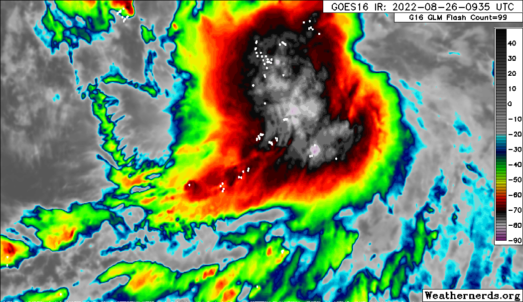
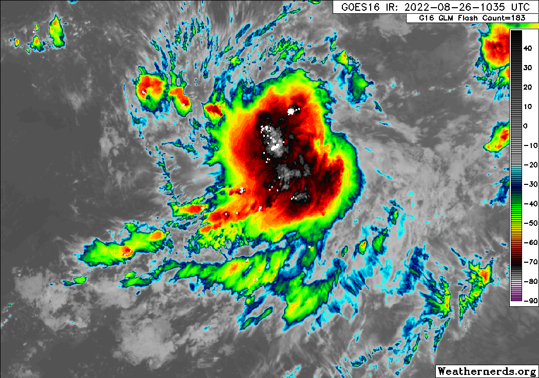
SFLcane wrote:toad strangler wrote:AutoPenalti wrote:Looks like it's puking outflow boundaries, it's crazy to think how dry the ATL is...
Ya, big time collapsing tops on the Eastern side
Looks great to me convection still expanding you can even see lighting there.
https://i.postimg.cc/RFkX1R1N/ir.gif
It could have a CDO already, that is way ahead of schedule!
3 likes
Bill 2015 & Beta 2020
Winter 2020-2021
All observations are in Tecumseh, OK unless otherwise noted.
Winter posts are focused mainly for Oklahoma & Texas.
Take any of my forecasts with a grain of salt, refer to the NWS, SPC, and NHC for official information
Never say Never with weather! Because ANYTHING is possible!
Winter 2020-2021
All observations are in Tecumseh, OK unless otherwise noted.
Winter posts are focused mainly for Oklahoma & Texas.
Take any of my forecasts with a grain of salt, refer to the NWS, SPC, and NHC for official information
Never say Never with weather! Because ANYTHING is possible!
-
skyline385

- Category 5
- Posts: 2728
- Age: 35
- Joined: Wed Aug 26, 2020 11:15 pm
- Location: Houston TX
Tropical Wave SW of the Cabo Verde Islands
USTropics wrote:
It's pretty simple, NHC is tracking the axis of the trailing wave. The mid-level surge from the trailing wave will pivot this complex north later today. My post from last night outlines this: https://www.storm2k.org/phpbb2/viewtopi ... 9#p2982319
Latest ECMWF (06z) shows this evolution as well:
Going to re-quote this excellent post from UStropics. There is a reason the NHC has it at 30% still and all the models are still not 100% decided on which blob will be the dominating one. We have had just one bullish operational run so far so give it some time, it’s very likely not close to 90% or a TD just yet.
Remember just last week how excellent the wave in the BoC looked and when recon got there, it was literally just a wave blowing convection off its axis with 90% off the winds in just one direction.
Sent from my iPhone using Tapatalk
5 likes
-
Blown Away

- S2K Supporter
- Posts: 10253
- Joined: Wed May 26, 2004 6:17 am
Re: Tropical Wave SW of the Cabo Verde Islands


Based on the 8am NHC Update "X", in that red circle it appears the beginning of a circulation.
Last edited by Blown Away on Fri Aug 26, 2022 9:20 am, edited 1 time in total.
0 likes
Hurricane Eye Experience: David 79, Irene 99, Frances 04, Jeanne 04, Wilma 05… Hurricane Brush Experience: Andrew 92, Erin 95, Floyd 99, Matthew 16, Irma 17, Ian 22, Nicole 22…
-
ElectricStorm

- Category 5
- Posts: 5148
- Age: 25
- Joined: Tue Aug 13, 2019 11:23 pm
- Location: Norman, OK
Re: Tropical Wave SW of the Cabo Verde Islands
I think this is going to end up being a pretty big mess with competing vorts fighting to become dominant, before finally developing closer to the islands. I think the GFS is way too bullish for now but I would be surprised if this doesn't end up developing.
0 likes
B.S Meteorology, University of Oklahoma '25
Please refer to the NHC, NWS, or SPC for official information.
Please refer to the NHC, NWS, or SPC for official information.
-
Iceresistance
- Category 5
- Posts: 9599
- Age: 22
- Joined: Sat Oct 10, 2020 9:45 am
- Location: Tecumseh, OK/Norman, OK
Re: Tropical Wave SW of the Cabo Verde Islands
skyline385 wrote:USTropics wrote:
It's pretty simple, NHC is tracking the axis of the trailing wave. The mid-level surge from the trailing wave will pivot this complex north later today. My post from last night outlines this: https://www.storm2k.org/phpbb2/viewtopi ... 9#p2982319
Latest ECMWF (06z) shows this evolution as well:
https://i.ibb.co/8Xd2Gvt/ecmwf-z850-vort-atl-fh0-90.gif
Going to re-quote this excellent post from UStropics. There is a reason the NHC has it at 30% still and all the models are still not 100% decided on which blob will be the dominating one. We have had just one bullish operational run so far so give it some time, it’s very likely not close to 90% or a TD just yet.
Remember just last week how excellent the wave in the BoC looked and when recon got there, it was literally just a wave blowing convection off its axis with 90% off the winds in just one direction.
Sent from my iPhone using Tapatalk
Keep in mind that every tropical wave is different to each other, there is evidence of a possible LLC with the low level clouds from the west of the convection moving east and some of those to the east are moving west, PTC 4 did not feature that.
2 likes
Bill 2015 & Beta 2020
Winter 2020-2021
All observations are in Tecumseh, OK unless otherwise noted.
Winter posts are focused mainly for Oklahoma & Texas.
Take any of my forecasts with a grain of salt, refer to the NWS, SPC, and NHC for official information
Never say Never with weather! Because ANYTHING is possible!
Winter 2020-2021
All observations are in Tecumseh, OK unless otherwise noted.
Winter posts are focused mainly for Oklahoma & Texas.
Take any of my forecasts with a grain of salt, refer to the NWS, SPC, and NHC for official information
Never say Never with weather! Because ANYTHING is possible!