Possible Development Near the GA/Bahamas (Is Invest 98L)
Moderator: S2k Moderators
Forum rules

The posts in this forum are NOT official forecasts and should not be used as such. They are just the opinion of the poster and may or may not be backed by sound meteorological data. They are NOT endorsed by any professional institution or STORM2K. For official information, please refer to products from the National Hurricane Center and National Weather Service.

Re: Possible Development Near the GA/Bahamas Early Next Week (20/60)
985mb at Apalachee Bay in 144 hrs
0 likes
Andy D
(For official information, please refer to the NHC and NWS products.)
(For official information, please refer to the NHC and NWS products.)
-
tolakram
- Admin

- Posts: 20186
- Age: 62
- Joined: Sun Aug 27, 2006 8:23 pm
- Location: Florence, KY (name is Mark)
Re: Possible Development Near the GA/Bahamas Early Next Week (20/60)
Here's the 12Z ICON

0 likes
M a r k
- - - - -
Join us in chat: Storm2K Chatroom Invite. Android and IOS apps also available.
The posts in this forum are NOT official forecasts and should not be used as such. Posts are NOT endorsed by any professional institution or STORM2K.org. For official information and forecasts, please refer to NHC and NWS products.
-
Blown Away

- S2K Supporter

- Posts: 10253
- Joined: Wed May 26, 2004 6:17 am
Re: Possible Development Near the GA/Bahamas Early Next Week (20/60)
12z CMC big shift W from 00z
0 likes
Hurricane Eye Experience: David 79, Irene 99, Frances 04, Jeanne 04, Wilma 05… Hurricane Brush Experience: Andrew 92, Erin 95, Floyd 99, Matthew 16, Irma 17, Ian 22, Nicole 22…
-
gatorcane

- S2K Supporter
- Posts: 23708
- Age: 48
- Joined: Sun Mar 13, 2005 3:54 pm
- Location: Boca Raton, FL
Re: Possible Development Near the GA/Bahamas Early Next Week (20/60)
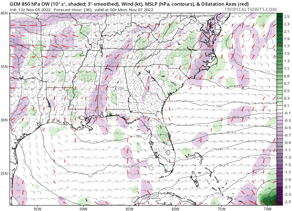
Complex situation with a broad low at the upper-levels working down to the surface and becoming possibly tropical. What model is better in this situation? Euro or GFS? I know the Euro has blown it in the past with Joaquin for example. Went from something broad/weak to a significant hurricane in one run.
Last edited by gatorcane on Sat Nov 05, 2022 11:30 am, edited 1 time in total.
0 likes

Re: Possible Development Near the GA/Bahamas Early Next Week (20/60)
We don't need no hurricane in November! Is you crazy?
0 likes
Re: Possible Development Near the GA/Bahamas Early Next Week (20/60)
The key distinctions between the models seem to be a result of just how quickly the 500mb heights begin to break down ahead of the strong short wave middle to end of next week. The other variable too of course, is how far east (or west) would any potential tropical cyclone actually be at around 102 hrs. The GFS clearly has a potential hurricane further west then other models; Regardless of forecast intensity, it would probably be prudent to watch how other models (especially EURO) trend in terms of timing of events. Bottom line for the moment is: Faster = No Bueno for Ian stricken Florida
0 likes
Andy D
(For official information, please refer to the NHC and NWS products.)
(For official information, please refer to the NHC and NWS products.)
-
Blown Away
- S2K Supporter
- Posts: 10253
- Joined: Wed May 26, 2004 6:17 am
Re: Possible Development Near the GA/Bahamas Early Next Week (20/60)
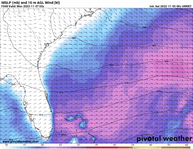
12z Ukmet
0 likes
Hurricane Eye Experience: David 79, Irene 99, Frances 04, Jeanne 04, Wilma 05… Hurricane Brush Experience: Andrew 92, Erin 95, Floyd 99, Matthew 16, Irma 17, Ian 22, Nicole 22…
Re: Possible Development Near the GA/Bahamas Early Next Week (20/60)
Blown Away wrote:[url]https://i.postimg.cc/G2SRMppY/floop-ukmet-2022110500-sfcwind-mslp-swatl.gif [/url]
12z Ukmet
Like the GFS, the UK is also rather suggestive of fairly strong ridging over the S.E. CONUS for the period out to 144 hrs.
0 likes
Andy D
(For official information, please refer to the NHC and NWS products.)
(For official information, please refer to the NHC and NWS products.)
-
Blown Away
- S2K Supporter
- Posts: 10253
- Joined: Wed May 26, 2004 6:17 am
Re: Possible Development Near the GA/Bahamas Early Next Week (20/60)
chaser1 wrote:The key distinctions between the models seem to be a result of just how quickly the 500mb heights begin to break down ahead of the strong short wave middle to end of next week. The other variable too of course, is how far east (or west) would any potential tropical cyclone actually be at around 102 hrs. The GFS clearly has a potential hurricane further west then other models; Regardless of forecast intensity, it would probably be prudent to watch how other models (especially EURO) trend in terms of timing of events. Bottom line for the moment is: Faster = No Bueno for Ian stricken Florida
00z Euro and 12z GFS about the same spot on/near FL in @120 hours. The 06z Euro out to 72 hours had a broad but better defined circulation than all previous runs. 12z Euro today will be a big tell if GFS intensity can be trusted. IMO
0 likes
Hurricane Eye Experience: David 79, Irene 99, Frances 04, Jeanne 04, Wilma 05… Hurricane Brush Experience: Andrew 92, Erin 95, Floyd 99, Matthew 16, Irma 17, Ian 22, Nicole 22…
Re: Possible Development Near the GA/Bahamas Early Next Week (20/60)
Blown Away wrote:[url]https://i.postimg.cc/G2SRMppY/floop-ukmet-2022110500-sfcwind-mslp-swatl.gif [/url]
12z Ukmet
Blown away I think that's the 00Z. The 12Z Ukmet run is slightly further south.
0 likes
Re: Possible Development Near the GA/Bahamas Early Next Week (20/60)
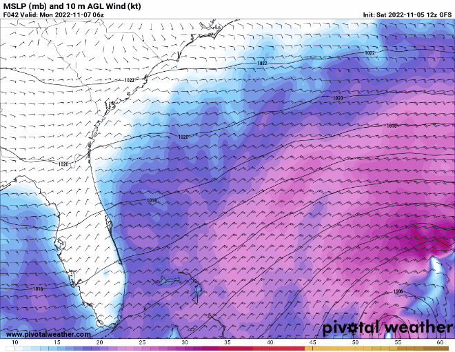
I'm a bit leery of the GFS 48 hr (Monday morning) forecast showing an already organizing tropical system well north of Hispaniola with a 1001mb pressure, then down to 998mb that same afternoon. Seems like a bit of a quick evolution from a very broad mid level low (unless a discreet low level vorticity does already exist and is able to maintain and deepen over this period of time).
1 likes
Andy D
(For official information, please refer to the NHC and NWS products.)
(For official information, please refer to the NHC and NWS products.)
-
Blown Away
- S2K Supporter
- Posts: 10253
- Joined: Wed May 26, 2004 6:17 am
Re: Possible Development Near the GA/Bahamas Early Next Week (20/60)
chaser1 wrote:Blown Away wrote:[url]https://i.postimg.cc/G2SRMppY/floop-ukmet-2022110500-sfcwind-mslp-swatl.gif [/url]
12z Ukmet
Like the GFS, the UK is also rather suggestive of fairly strong ridging over the S.E. CONUS for the period out to 144 hrs.
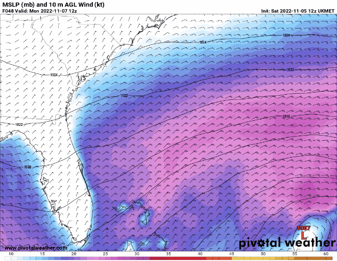
I accidentally posted 00z Ukmet in post above. This is the 12z Ukmet today showing a 1001 mb into FL. I may be wrong, but the Ukmet showing a 1001 mb TS is pretty aggressive for Ukmet.
3 likes
Hurricane Eye Experience: David 79, Irene 99, Frances 04, Jeanne 04, Wilma 05… Hurricane Brush Experience: Andrew 92, Erin 95, Floyd 99, Matthew 16, Irma 17, Ian 22, Nicole 22…
-
cycloneye

- Admin
- Posts: 149568
- Age: 69
- Joined: Thu Oct 10, 2002 10:54 am
- Location: San Juan, Puerto Rico
Re: Possible Development Near the GA/Bahamas Early Next Week (20/60)
Blown Away, UKMET is always a conservative model and to have that solution is telling.
1 likes
Visit the Caribbean-Central America Weather Thread where you can find at first post web cams,radars
and observations from Caribbean basin members Click Here
and observations from Caribbean basin members Click Here
-
jlauderdal
- S2K Supporter
- Posts: 7240
- Joined: Wed May 19, 2004 5:46 am
- Location: NE Fort Lauderdale
- Contact:
Re: RE: Re: Possible Development Near the GA/Bahamas Early Next Week (20/60)
Thats worthy of full preps. I still have plenty of fuel from ian preps.Blown Away wrote:
12z GFS back with Cat 1/2 into SFL in 4-5 days..
0 likes
Re: Possible Development Near the GA/Bahamas Early Next Week (20/60)
Blown Away wrote:chaser1 wrote:The key distinctions between the models seem to be a result of just how quickly the 500mb heights begin to break down ahead of the strong short wave middle to end of next week. The other variable too of course, is how far east (or west) would any potential tropical cyclone actually be at around 102 hrs. The GFS clearly has a potential hurricane further west then other models; Regardless of forecast intensity, it would probably be prudent to watch how other models (especially EURO) trend in terms of timing of events. Bottom line for the moment is: Faster = No Bueno for Ian stricken Florida
00z Euro and 12z GFS about the same spot on/near FL in @120 hours. The 06z Euro out to 72 hours had a broad but better defined circulation than all previous runs. 12z Euro today will be a big tell if GFS intensity can be trusted. IMO
Agreed; 6Z was about 1 mb lower but more importantly it's timing of a Florida approaching low seems similar to the GFS.
0 likes
Andy D
(For official information, please refer to the NHC and NWS products.)
(For official information, please refer to the NHC and NWS products.)
-
jlauderdal
- S2K Supporter
- Posts: 7240
- Joined: Wed May 19, 2004 5:46 am
- Location: NE Fort Lauderdale
- Contact:
Re: RE: Re: Possible Development Near the GA/Bahamas Early Next Week (20/60)
It was aggressive with ian and nailed the trackcycloneye wrote:Blown Away, UKMET is always a conservative model and to have that solution is telling.
1 likes
-
Blown Away
- S2K Supporter
- Posts: 10253
- Joined: Wed May 26, 2004 6:17 am
Re: Possible Development Near the GA/Bahamas Early Next Week (20/60)
cycloneye wrote:Blown Away, UKMET is always a conservative model and to have that solution is telling.
GCANE observed the AOI moving through Mona Pass instead of over or E of you in PR. That may be the reason PR is now getting more rain & wind and may bring a stronger system into Bahamas/FL?
1 likes
Hurricane Eye Experience: David 79, Irene 99, Frances 04, Jeanne 04, Wilma 05… Hurricane Brush Experience: Andrew 92, Erin 95, Floyd 99, Matthew 16, Irma 17, Ian 22, Nicole 22…
-
cycloneye
- Admin
- Posts: 149568
- Age: 69
- Joined: Thu Oct 10, 2002 10:54 am
- Location: San Juan, Puerto Rico
Re: Possible Development Near the GA/Bahamas Early Next Week (20/60)
Blown Away wrote:cycloneye wrote:Blown Away, UKMET is always a conservative model and to have that solution is telling.
GCANE observed the AOI moving through Mona Pass instead of over or E of you in PR. That may be the reason PR is now getting more rain & wind and may bring a stronger system into Bahamas/FL?
Is raining in all the island with flooding occuring in some places.

0 likes
Visit the Caribbean-Central America Weather Thread where you can find at first post web cams,radars
and observations from Caribbean basin members Click Here
and observations from Caribbean basin members Click Here
-
AtlanticWind

- S2K Supporter
- Posts: 1898
- Age: 67
- Joined: Sun Aug 08, 2004 9:57 pm
- Location: Plantation,Fla
Re: Possible Development Near the GA/Bahamas Early Next Week (20/60)
This is kinda surreal that we could possibly be dealing with a hurricane
as quickly as Wednesday / Thursday and in the middle of November in
S. Florida.
I think this would take people by suprise if hurricane watches go up Monday
Evening which would have to done if we were to believe the GFS.
as quickly as Wednesday / Thursday and in the middle of November in
S. Florida.
I think this would take people by suprise if hurricane watches go up Monday
Evening which would have to done if we were to believe the GFS.
0 likes
-
cycloneye
- Admin
- Posts: 149568
- Age: 69
- Joined: Thu Oct 10, 2002 10:54 am
- Location: San Juan, Puerto Rico
Re: Possible Development Near the GA/Bahamas Early Next Week (40/70)
This will be invest 98L very soon.
Southwestern Atlantic:
A trough of low pressure located over the eastern Caribbean Sea is
producing a large area of disorganized showers and thunderstorms.
The trough is forecast to move northward over the southwestern
Atlantic by Sunday, where a broad area of low pressure is expected
to form north of Hispaniola. Environmental conditions are forecast
to be conducive for gradual development, and a subtropical or
tropical depression could form during the early part of next week
while the system moves generally westward to west-northwestward over
the southwestern Atlantic. Regardless of development, there is an
increasing risk of coastal flooding, gale-force winds, heavy
rainfall, rough surf, and beach erosion along much of the
southeastern United States coast, the Florida east coast, and
portions of the central and northwestern Bahamas during the early
to middle part of next week. The disturbance is also expected to
bring locally heavy rainfall to Puerto Rico and the Virgin Islands
this weekend. Interests in those areas should monitor the progress
of this system.
* Formation chance through 48 hours...medium...40 percent.
* Formation chance through 5 days...high...70 percent.
0 likes
Visit the Caribbean-Central America Weather Thread where you can find at first post web cams,radars
and observations from Caribbean basin members Click Here
and observations from Caribbean basin members Click Here
Who is online
Users browsing this forum: No registered users and 108 guests