2024 Indicators: SST's, MSLP, Shear, SAL, Steering, Instability (Day 16+ Climate Models)
Moderator: S2k Moderators
Forum rules

The posts in this forum are NOT official forecasts and should not be used as such. They are just the opinion of the poster and may or may not be backed by sound meteorological data. They are NOT endorsed by any professional institution or STORM2K. For official information, please refer to products from the National Hurricane Center and National Weather Service.
-
Deshaunrob17
- Tropical Storm

- Posts: 211
- Joined: Tue Aug 18, 2020 7:49 am
Re: 2024 Indicators: SST's, ENSO, MSLP, Shear, SAL, Steering, Instability, (Day 16+ Climate Models)
The only major thing i could see that go wrong is of La Nina gets too strong.. Strong La Ninas can throw an unexpected curveball
3 likes
-
Iceresistance

- Category 5

- Posts: 9607
- Age: 22
- Joined: Sat Oct 10, 2020 9:45 am
- Location: Tecumseh, OK/Norman, OK
Re: 2024 Indicators: SST's, ENSO, MSLP, Shear, SAL, Steering, Instability, (Day 16+ Climate Models)
0 likes
Bill 2015 & Beta 2020
Winter 2020-2021
All observations are in Tecumseh, OK unless otherwise noted.
Winter posts are focused mainly for Oklahoma & Texas.
Take any of my forecasts with a grain of salt, refer to the NWS, SPC, and NHC for official information
Never say Never with weather! Because ANYTHING is possible!
Winter 2020-2021
All observations are in Tecumseh, OK unless otherwise noted.
Winter posts are focused mainly for Oklahoma & Texas.
Take any of my forecasts with a grain of salt, refer to the NWS, SPC, and NHC for official information
Never say Never with weather! Because ANYTHING is possible!

Re: 2024 Indicators: SST's, ENSO, MSLP, Shear, SAL, Steering, Instability, (Day 16+ Climate Models)
Deshaunrob17 wrote:The only major thing i could see that go wrong is of La Nina gets too strong.. Strong La Ninas can throw an unexpected curveball
Same…the most likely hinderance out of anything else other than MDR cooling between now and then but I don’t think a strong La Nina will be able to manifest right out of the gate. Especially when the atmosphere is still firmly in El Nino right now.
0 likes
-
Hurricane2022

- Category 5
- Posts: 2092
- Joined: Tue Aug 23, 2022 11:38 pm
- Location: Araçatuba, Brazil
Re: 2024 Indicators: SST's, ENSO, MSLP, Shear, SAL, Steering, Instability, (Day 16+ Climate Models)
At the end of September it will be possible to cook good Italian pasta in the infernal waters of the WCAR, which will be above 34°C

3 likes
Sorry for the bad English sometimes...!
For reliable and detailed information for any meteorological phenomenon, please consult the National Hurricane Center, Joint Typhoon Warning Center , or your local Meteo Center.
--------
ECCE OMNIA NOVA FACIAM (Ap 21,5).
For reliable and detailed information for any meteorological phenomenon, please consult the National Hurricane Center, Joint Typhoon Warning Center , or your local Meteo Center.
--------
ECCE OMNIA NOVA FACIAM (Ap 21,5).
Re: 2024 Indicators: SST's, ENSO, MSLP, Shear, SAL, Steering, Instability, (Day 16+ Climate Models)
Deshaunrob17 wrote:The only major thing i could see that go wrong is of La Nina gets too strong.. Strong La Ninas can throw an unexpected curveball
I’d call that going “right” rather than going “wrong” from my perspective of always wanting a relatively quiet season. I’ll be hoping. Here’s something else. Should the cold last half of Feb and early March predicted for the SE US verify, maybe that would bring down GOM SSTs/OHC some for the early season. I know, wishful thinking in this warmer world.
0 likes
Personal Forecast Disclaimer:
The posts in this forum are NOT official forecasts and should not be used as such. They are just the opinion of the poster and may or may not be backed by sound meteorological data. They are NOT endorsed by any professional institution or storm2k.org. For official information, please refer to the NHC and NWS products.
The posts in this forum are NOT official forecasts and should not be used as such. They are just the opinion of the poster and may or may not be backed by sound meteorological data. They are NOT endorsed by any professional institution or storm2k.org. For official information, please refer to the NHC and NWS products.
-
cycloneye

- Admin

- Posts: 149720
- Age: 69
- Joined: Thu Oct 10, 2002 10:54 am
- Location: San Juan, Puerto Rico
Re: 2024 Indicators: SST's, ENSO, MSLP, Shear, SAL, Steering, Instability, (Day 16+ Climate Models)
0 likes
Visit the Caribbean-Central America Weather Thread where you can find at first post web cams,radars
and observations from Caribbean basin members Click Here
and observations from Caribbean basin members Click Here
-
SFLcane

- S2K Supporter

- Posts: 10281
- Age: 48
- Joined: Sat Jun 05, 2010 1:44 pm
- Location: Lake Worth Florida
Re: 2024 Indicators: SST's, ENSO, MSLP, Shear, SAL, Steering, Instability, (Day 16+ Climate Models)
This looks pretty scary to say the least. New Feb Cánsips


1 likes
-
DorkyMcDorkface

- Category 5
- Posts: 1043
- Age: 28
- Joined: Mon Sep 30, 2019 1:32 pm
- Location: Mid-Atlantic
Re: 2024 Indicators: SST's, ENSO, MSLP, Shear, SAL, Steering, Instability, (Day 16+ Climate Models)
SFLcane wrote:This looks pretty scary to say the least. New Feb Cánsips
https://i.postimg.cc/mgFgQLMW/IMG-8427.gif
https://i.postimg.cc/WzCP3Z5F/IMG-8430.gif
Legend has it if you look up "hyperactive" in the dictionary you'll see this graphic.
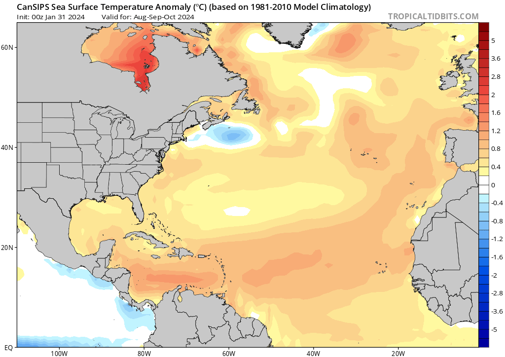
In all seriousness hopefully this doesn't verify. That's about as good as it gets when it comes to NATL favorability.
3 likes
Please note the thoughts expressed by this account are solely those of the user and are from a hobbyist perspective. For more comprehensive analysis, consult an actual professional meteorologist or meteorological agency.
Floyd 1999 | Isabel 2003 | Hanna 2008 | Irene 2011 | Sandy 2012 | Isaias 2020

-
cycloneye
- Admin
- Posts: 149720
- Age: 69
- Joined: Thu Oct 10, 2002 10:54 am
- Location: San Juan, Puerto Rico
Re: 2024 Indicators: SST's, ENSO, MSLP, Shear, SAL, Steering, Instability, (Day 16+ Climate Models) Update= CanSIPS mode
Mark the Febuary 8th date.
1- The CPC ENSO Febuary update will be out when they will give the latest percent for Neutral. In the January one, it had 73% of Neutral by June.
2-The NMME climate model will be out with the Febuary update.
1- The CPC ENSO Febuary update will be out when they will give the latest percent for Neutral. In the January one, it had 73% of Neutral by June.
2-The NMME climate model will be out with the Febuary update.
2 likes
Visit the Caribbean-Central America Weather Thread where you can find at first post web cams,radars
and observations from Caribbean basin members Click Here
and observations from Caribbean basin members Click Here
-
cycloneye
- Admin
- Posts: 149720
- Age: 69
- Joined: Thu Oct 10, 2002 10:54 am
- Location: San Juan, Puerto Rico
Re: 2024 Indicators: SST's, ENSO, MSLP, Shear, SAL, Steering, Instability, (Day 16+ Climate Models) Update= CanSIPS mode
0 likes
Visit the Caribbean-Central America Weather Thread where you can find at first post web cams,radars
and observations from Caribbean basin members Click Here
and observations from Caribbean basin members Click Here
-
Category5Kaiju

- Category 5
- Posts: 4346
- Joined: Thu Dec 24, 2020 12:45 pm
- Location: Seattle during the summer, Phoenix during the winter
Re: 2024 Indicators: SST's, MSLP, Shear, SAL, Steering, Instability, (Day 16+ Climate Models) Update= CanSIPS model up
In previous years, it has always seemed, during the pre-season, as if there was at least one factor that was preventing us from immediately concluding that a season would be very active and impactful. Last year, it was the imminent strong Nino. In 2022, it was rather meager sst anomalies and a third year Nina. In 2021, it was the Atlantic Nino.
This year is on another planet in regards to this. It's almost to the point that I don't really have much to comment on aside from the fact that we seriously need to be prepared.
This year is on another planet in regards to this. It's almost to the point that I don't really have much to comment on aside from the fact that we seriously need to be prepared.
0 likes
Unless explicitly stated, all information in my posts is based on my own opinions and observations. Tropical storms and hurricanes can be extremely dangerous. Refer to an accredited weather research agency or meteorologist if you need to make serious decisions regarding an approaching storm.
-
DorkyMcDorkface
- Category 5
- Posts: 1043
- Age: 28
- Joined: Mon Sep 30, 2019 1:32 pm
- Location: Mid-Atlantic
Re: 2024 Indicators: SST's, MSLP, Shear, SAL, Steering, Instability, (Day 16+ Climate Models) Update= CanSIPS model up
Category5Kaiju wrote:In previous years, it has always seemed, during the pre-season, as if there was at least one factor that was preventing us from immediately concluding that a season would be very active and impactful. Last year, it was the imminent strong Nino. In 2022, it was rather meager sst anomalies and a third year Nina. In 2021, it was the Atlantic Nino.
This year is on another planet in regards to this. It's almost to the point that I don't really have much to comment on aside from the fact that we seriously need to be prepared.
Talked about this a while back but it's worth mentioning 2021's strong Atlantic Nino actually aided early season MDR development with Elsa. Outside of the ITCZ being lower in latitude which allowed for the precursor wave to lay low away from the usual early season suspects and keep it over warmer waters there was actually a bit of a a trade wind reversal (almost like a mini-WWB of sorts) near the equatorial Atlantic which enhanced background vorticity and ultimately helped get Elsa going, was a really cool and rare phenomenon. But of course you're probably alluding to late season where waves could not gain sufficient latitude to develop in the WATL, though an unfavorable intraseasonal state also didn't help matters.
3 likes
Please note the thoughts expressed by this account are solely those of the user and are from a hobbyist perspective. For more comprehensive analysis, consult an actual professional meteorologist or meteorological agency.
Floyd 1999 | Isabel 2003 | Hanna 2008 | Irene 2011 | Sandy 2012 | Isaias 2020
-
SFLcane
- S2K Supporter
- Posts: 10281
- Age: 48
- Joined: Sat Jun 05, 2010 1:44 pm
- Location: Lake Worth Florida
Re: 2024 Indicators: SST's, MSLP, Shear, SAL, Steering, Instability, (Day 16+ Climate Models) Update= CanSIPS model up
Certainly not surprised given the difference in SSTA
0 likes


Re: 2024 Indicators: SST's, MSLP, Shear, SAL, Steering, Instability, (Day 16+ Climate Models) Update= CanSIPS model up
SFLcane wrote:Certainly not surprised given the difference in SSTA
at this rate we might as well have a February alberto and an april beryl
0 likes
blonde stacey (xe/xem/xir)
-
tolakram
- Admin
- Posts: 20186
- Age: 62
- Joined: Sun Aug 27, 2006 8:23 pm
- Location: Florence, KY (name is Mark)
Re: 2024 Indicators: SST's, MSLP, Shear, SAL, Steering, Instability, (Day 16+ Climate Models) Update= CanSIPS model up
How about Sahara dust? Any indicators we can look at to predict how good or bad dust outbreaks will be? From the looks of it we will need MDR activity to reach a hyperactive season, which means dust is going to be a factor. I'm not claiming to know anything here, just asking.
0 likes
M a r k
- - - - -
Join us in chat: Storm2K Chatroom Invite. Android and IOS apps also available.
The posts in this forum are NOT official forecasts and should not be used as such. Posts are NOT endorsed by any professional institution or STORM2K.org. For official information and forecasts, please refer to NHC and NWS products.
-
WeatherBoy2000
- Category 1

- Posts: 463
- Joined: Mon Apr 10, 2023 9:29 am
Re: 2024 Indicators: SST's, MSLP, Shear, SAL, Steering, Instability, (Day 16+ Climate Models) Update= CanSIPS model up
tolakram wrote:How about Sahara dust? Any indicators we can look at to predict how good or bad dust outbreaks will be? From the looks of it we will need MDR activity to reach a hyperactive season, which means dust is going to be a factor. I'm not claiming to know anything here, just asking.
There was a twitter thread by I think Eric Webb that talked about how a warmer Canary current region typically lends itself towards a more moist deep tropics with less dry air/SAL issues. How warm that region is by the summer might give us a clue on how much dry air will be issue.
1 likes
-
TheWisestofAll

- Tropical Low

- Posts: 23
- Joined: Sun Dec 15, 2019 10:17 pm
Re: 2024 Indicators: SST's, MSLP, Shear, SAL, Steering, Instability, (Day 16+ Climate Models) Update= CanSIPS model up
WeatherBoy2000 wrote:tolakram wrote:How about Sahara dust? Any indicators we can look at to predict how good or bad dust outbreaks will be? From the looks of it we will need MDR activity to reach a hyperactive season, which means dust is going to be a factor. I'm not claiming to know anything here, just asking.
There was a twitter thread by I think Eric Webb that talked about how a warmer Canary current region typically lends itself towards a more moist deep tropics with less dry air/SAL issues. How warm that region is by the summer might give us a clue on how much dry air will be issue.
If its anything like last year then we have a lot to worry about. SAL was basically down around peak season levels the entire summer, and we didn't get any major dust outbreaks until late. I don't believe dry air in general was that big of an issue either, but the shear from the competing Nino probably played a factor in whatever effect it did have.
1 likes
Who is online
Users browsing this forum: hcane27, Yellow Evan and 156 guests