Possible development in the Western Atlantic / GOM (Is Invest 97L)
Moderator: S2k Moderators
Forum rules

The posts in this forum are NOT official forecasts and should not be used as such. They are just the opinion of the poster and may or may not be backed by sound meteorological data. They are NOT endorsed by any professional institution or STORM2K. For official information, please refer to products from the National Hurricane Center and National Weather Service.
Re: Possible development in the central Atlantic (0/40)
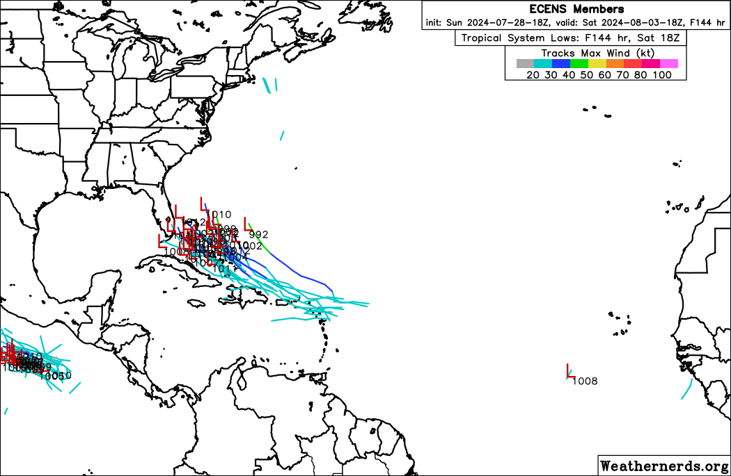
18Z GEFS: I count 4 TCs (13% of 31 members). They’re all in the Gulf. This is the first GEFS run in a couple of days with TCs mainly or all in Gulf.
1 likes
Personal Forecast Disclaimer:
The posts in this forum are NOT official forecasts and should not be used as such. They are just the opinion of the poster and may or may not be backed by sound meteorological data. They are NOT endorsed by any professional institution or storm2k.org. For official information, please refer to the NHC and NWS products.
The posts in this forum are NOT official forecasts and should not be used as such. They are just the opinion of the poster and may or may not be backed by sound meteorological data. They are NOT endorsed by any professional institution or storm2k.org. For official information, please refer to the NHC and NWS products.

Re: Possible development in the central Atlantic (0/40)
ScottNAtlanta wrote:I think all the people who are saying the Icon did so well with Beryl need to remember it did well after you had a coherent system. It's not very good with genesis. So far the GFS has been better on that account (it sniffed out Beryl well before the other models). Many of these models are not going to be so good until the system is forming.
This is (not wrong sorry for missing the point) wrong Scott. We showed ICON had it roughly a week + out in that thread. Check the last couple pages of the archived model thread. We could only go back to Sunday before 12z on tidbits but it was money.
Last edited by Steve on Sun Jul 28, 2024 8:50 pm, edited 1 time in total.
3 likes

Re: Possible development in the central Atlantic (0/40)
Steve wrote:ScottNAtlanta wrote:I think all the people who are saying the Icon did so well with Beryl need to remember it did well after you had a coherent system. It's not very good with genesis. So far the GFS has been better on that account (it sniffed out Beryl well before the other models). Many of these models are not going to be so good until the system is forming.
This is wrong Scott. We showed ICON had it roughly a week + out in that thread. Check the last couple pages of the archived model thread. We could only go back to Sunday before 12z on tidbits but it was money.
That run initialized Sunday 6/30, by which point Beryl was already a hurricane. It did excel once Beryl was a tangible system.
Scott is saying ICON was poorer with the genesis - and it was. Ensembles support picked up by 6/22 and operational support was strong (GFS had a hurricane) by 6/24. ICON had a weak low by this point, but did not develop a TD until 12z of 6/26. For what it's worth the op Euro was inconsistent and didn't consistently settle on development until that same cycle. Same thing we saw with this system earlier.
5 likes
Kendall -> SLO -> PBC
Memorable Storms: Katrina (for its Florida landfall...) Wilma Matthew Irma
Memorable Storms: Katrina (for its Florida landfall...) Wilma Matthew Irma
-
SFLcane

- S2K Supporter

- Posts: 10281
- Age: 48
- Joined: Sat Jun 05, 2010 1:44 pm
- Location: Lake Worth Florida
Re: Possible development in the central Atlantic (0/40)
18z eps with a west shift closer to the southeast and FL.
5 likes
Re: Possible development in the central Atlantic (0/40)
Ubuntwo wrote:Steve wrote:ScottNAtlanta wrote:I think all the people who are saying the Icon did so well with Beryl need to remember it did well after you had a coherent system. It's not very good with genesis. So far the GFS has been better on that account (it sniffed out Beryl well before the other models). Many of these models are not going to be so good until the system is forming.
This is wrong Scott. We showed ICON had it roughly a week + out in that thread. Check the last couple pages of the archived model thread. We could only go back to Sunday before 12z on tidbits but it was money.
That run initialized Sunday 6/30, by which point Beryl was already a hurricane. It did excel once Beryl was a tangible system.
Scott is saying ICON was poorer with the genesis - and it was. Ensembles support picked up by 6/22 and operational support was strong (GFS had a hurricane) by 6/24. ICON had a weak low by this point, but did not develop a TD until 12z of 6/26. For what it's worth the op Euro was inconsistent and didn't consistently settle on development until that same cycle. Same thing we saw with this system earlier.
Straight had it where it ended up though. Not researching but I remember GFS with multiple solutions. But if we are only talking genesis, not sure I agree as a general statement. Icon was early sniffing at least one every season since Levi started showing it which is when I started looking at it. Obviously GFS/Euro are the standards and more so their ensembles. Didn’t mean to discount the point I looked past. But Scott already knows I love his posts by the amount of likes I always give him.
4 likes
Re: Possible development in the central Atlantic (0/40)
Steve wrote:Ubuntwo wrote:Steve wrote:
This is wrong Scott. We showed ICON had it roughly a week + out in that thread. Check the last couple pages of the archived model thread. We could only go back to Sunday before 12z on tidbits but it was money.
That run initialized Sunday 6/30, by which point Beryl was already a hurricane. It did excel once Beryl was a tangible system.
Scott is saying ICON was poorer with the genesis - and it was. Ensembles support picked up by 6/22 and operational support was strong (GFS had a hurricane) by 6/24. ICON had a weak low by this point, but did not develop a TD until 12z of 6/26. For what it's worth the op Euro was inconsistent and didn't consistently settle on development until that same cycle. Same thing we saw with this system earlier.
Straight had it where it ended up though. Not researching but I remember GFS with multiple solutions. But if we are only talking genesis, not sure I agree as a general statement. Icon was early sniffing at least one every season since Levi started showing it which is when I started looking at it. Obviously GFS/Euro are the standards and more so their ensembles. Didn’t mean to discount the point I looked past. But Scott already knows I love his posts by the amount of likes I always give him.
That Texas landfall solution was very impressive. Same thing with Ian and SWFL. And it's had some impressive genesis calls, Fay 2020 stands out to me. It's not as consistent in that regard but always worth a look in the model rotation.
0 likes
Kendall -> SLO -> PBC
Memorable Storms: Katrina (for its Florida landfall...) Wilma Matthew Irma
Memorable Storms: Katrina (for its Florida landfall...) Wilma Matthew Irma
Re: Possible development in the central Atlantic (0/40)
0z icon shifted right (still stays west of key west), but comes up and gets into the Big Bend near St. Marks (TS)

0 likes
-
Stratton23
- Category 5

- Posts: 3563
- Joined: Fri Jul 21, 2023 10:59 pm
- Location: Katy, Tx
Re: Possible development in the central Atlantic (0/40)
Wonky GFS run, wave heads toward florida, but now gets caught under neath by a building ridge, and the wave axis is now propagating westward through the gulf of mexico,
south of new orleans at hour 228
south of new orleans at hour 228
0 likes
Re: Possible development in the central Atlantic (0/40)
0z GFS elongates the wave due to competition between lobes while passing over the Greater Antilles. The north side has more energy (favoring a solution like the Euro), but higher shear north of the Antilles keeps that south side kicking. Delays the bundling up process.
0 likes
Kendall -> SLO -> PBC
Memorable Storms: Katrina (for its Florida landfall...) Wilma Matthew Irma
Memorable Storms: Katrina (for its Florida landfall...) Wilma Matthew Irma
-
Stratton23
- Category 5
- Posts: 3563
- Joined: Fri Jul 21, 2023 10:59 pm
- Location: Katy, Tx
Re: Possible development in the central Atlantic (0/40)
GFS still brings a ton of rain to the north and eastern gulf coast, the wave just kinda stalls out again like what it did on the 18z GFS, steering could get weak in the gulf
0 likes
Re: Possible development in the central Atlantic (0/40)
Despite no development on the operational, the 0z GFS ensembles are around the second-most active yet with 6 members (20%) developing. A couple into Florida with the rest curving off the southeast US. Several of these become hurricanes.
0 likes
Kendall -> SLO -> PBC
Memorable Storms: Katrina (for its Florida landfall...) Wilma Matthew Irma
Memorable Storms: Katrina (for its Florida landfall...) Wilma Matthew Irma
-
emeraldislenc
- Category 2

- Posts: 601
- Joined: Fri Aug 24, 2012 4:49 pm
- Location: Emerald Isle NC
Re: Possible development in the central Atlantic (0/40)
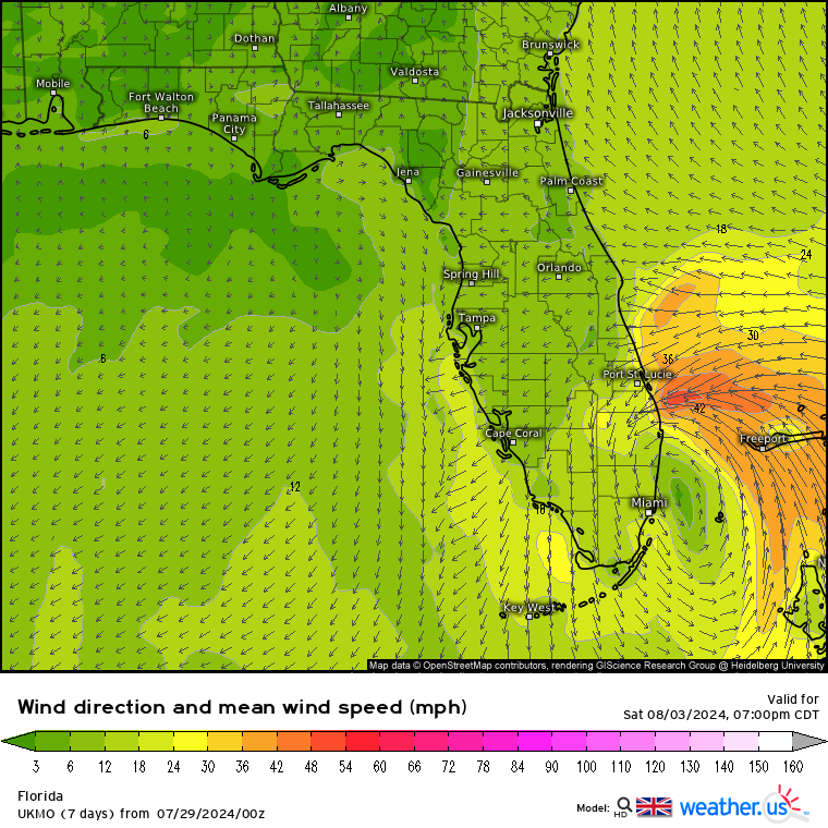
0Z CMC similar to ICON with TS into FL panhandle
0Z Euro 1006 mb TD/TS into NC OB
0Z UKMET: TS just off FL E coast that then turns NNE
NEW TROPICAL CYCLONE FORECAST TO DEVELOP AFTER 132 HOURS
FORECAST POSITION AT T+132 : 24.8N 77.9W
LEAD CENTRAL MAXIMUM WIND
VERIFYING TIME TIME POSITION PRESSURE (MB) SPEED (KNOTS)
-------------- ---- -------- ------------- -------------
1200UTC 03.08.2024 132 24.8N 77.9W 1009 42
0000UTC 04.08.2024 144 26.3N 79.5W 1005 47
1200UTC 04.08.2024 156 28.2N 80.2W 1006 33
0000UTC 05.08.2024 168 30.0N 79.6W 1006 34
1 likes
Personal Forecast Disclaimer:
The posts in this forum are NOT official forecasts and should not be used as such. They are just the opinion of the poster and may or may not be backed by sound meteorological data. They are NOT endorsed by any professional institution or storm2k.org. For official information, please refer to the NHC and NWS products.
The posts in this forum are NOT official forecasts and should not be used as such. They are just the opinion of the poster and may or may not be backed by sound meteorological data. They are NOT endorsed by any professional institution or storm2k.org. For official information, please refer to the NHC and NWS products.
-
SFLcane
- S2K Supporter
- Posts: 10281
- Age: 48
- Joined: Sat Jun 05, 2010 1:44 pm
- Location: Lake Worth Florida
Re: Possible development in the central Atlantic (0/40)
LarryWx wrote:0Z CMC similar to ICON with TS into FL panhandle
0Z Euro 1006 mb TD/TS into NC OB
0Z UKMET: TS just off FL E coast that then turns NNE
NEW TROPICAL CYCLONE FORECAST TO DEVELOP AFTER 132 HOURS
FORECAST POSITION AT T+132 : 24.8N 77.9W
LEAD CENTRAL MAXIMUM WIND
VERIFYING TIME TIME POSITION PRESSURE (MB) SPEED (KNOTS)
-------------- ---- -------- ------------- -------------
1200UTC 03.08.2024 132 24.8N 77.9W 1009 42
0000UTC 04.08.2024 144 26.3N 79.5W 1005 47
1200UTC 04.08.2024 156 28.2N 80.2W 1006 33
0000UTC 05.08.2024 168 30.0N 79.6W 1006 34
00z Ukmet about a mid grade TS into WPB it seems.
1 likes
-
Hypercane_Kyle

- Category 5
- Posts: 3465
- Joined: Sat Mar 07, 2015 7:58 pm
- Location: Cape Canaveral, FL
Re: Possible development in the central Atlantic (0/50)
Pretty strong model support for a TS in the Bahamas by Saturday.
GFS alone in its camp, likely struggling with overall background with El Nino-esque back-to-back Category 4+ storms in the EPAC.
GFS alone in its camp, likely struggling with overall background with El Nino-esque back-to-back Category 4+ storms in the EPAC.
0 likes
My posts are my own personal opinion, defer to the National Hurricane Center (NHC) and other NOAA products for decision making during hurricane season.

Re: Possible development in the central Atlantic (0/50)
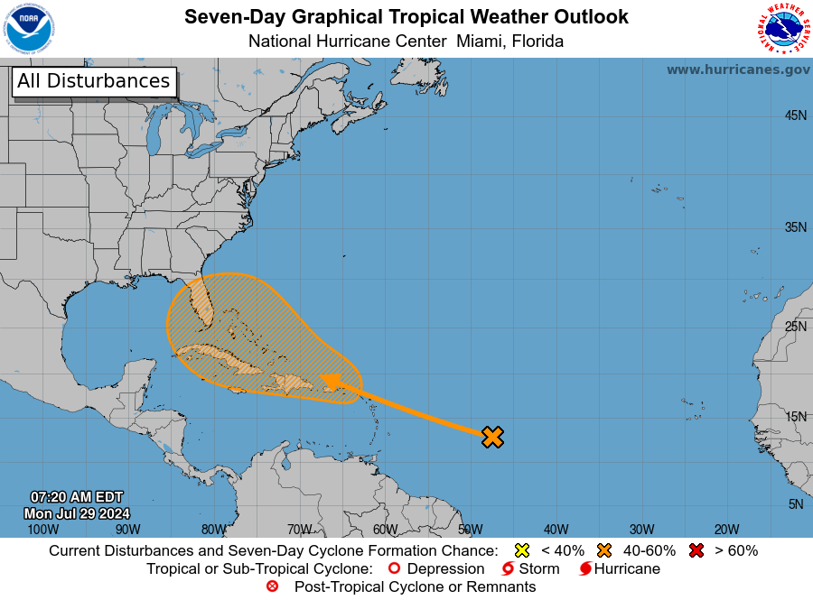
Tropical Weather Outlook
NWS National Hurricane Center Miami FL
800 AM EDT Mon Jul 29 2024
For the North Atlantic...Caribbean Sea and the Gulf of Mexico:
1. Near the Leeward Islands and Greater Antilles:
An area of disturbed weather over the central tropical Atlantic
Ocean is expected to interact with an approaching tropical wave
during the next couple of days. Environmental conditions are
forecast to become conducive for some development thereafter, and a
tropical depression could form later this week while the system is
in the vicinity of the Greater Antilles or the Bahamas.
* Formation chance through 48 hours...low...near 0 percent.
* Formation chance through 7 days...medium...50 percent.
Forecaster Cangialosi
0 likes
-
toad strangler

- S2K Supporter
- Posts: 4546
- Joined: Sun Jul 28, 2013 3:09 pm
- Location: Earth
- Contact:
Re: Possible development in the central Atlantic (0/50)
6z GFS ensembles are the most active yet with 40-50% developing, in spite of the operational. Most are hovering around moderate TS intensity. The vast majority also agree with the developing consensus on a Bahamas/SE US track.

Last edited by Ubuntwo on Mon Jul 29, 2024 7:09 am, edited 1 time in total.
0 likes
Kendall -> SLO -> PBC
Memorable Storms: Katrina (for its Florida landfall...) Wilma Matthew Irma
Memorable Storms: Katrina (for its Florida landfall...) Wilma Matthew Irma
-
Frank P
- S2K Supporter
- Posts: 2779
- Joined: Fri Aug 29, 2003 10:52 am
- Location: Biloxi Beach, Ms
- Contact:
Re: Possible development in the central Atlantic (0/50)
morning vis sat loop show a low level circ trying to get spinning.

0 likes
Re: Possible development in the central Atlantic (0/50)
Frank P wrote:morning vis sat loop show a low level circ trying to get spinning.
[url]https://i.ibb.co/Z6vGWks/goes16-truecolor-catl.gif [/url]
Good morning yall....where is the area u mention?...on tha right side of the image?...I have read a few forecast discussions up and down the Florida peninsula...sounding like this system will make its presence known there in whatever form it may take?...
0 likes
Who is online
Users browsing this forum: South Texas Storms and 135 guests