2023 Global Model Runs Discussion (Out thru day 16)
Moderator: S2k Moderators
Forum rules

The posts in this forum are NOT official forecasts and should not be used as such. They are just the opinion of the poster and may or may not be backed by sound meteorological data. They are NOT endorsed by any professional institution or STORM2K. For official information, please refer to products from the National Hurricane Center and National Weather Service.
Re: 2023 Global Model Runs Discussion (Out thru day 16)
SFLcane wrote:Definitely a GFS bias spot…Careful
CMC, and GFS each run showing something similar. 18z ensembles more active as well, and timeline moved up a tad too. CPC also highlighting possible development mid to late month as well.

0 likes

Re: 2023 Global Model Runs Discussion (Out thru day 16)
SFLcane wrote:Definitely a GFS bias spot…Careful
agreed! 12z euro not showing much at this point.....
0 likes


Re: 2023 Global Model Runs Discussion (Out thru day 16)
mantis83 wrote:SFLcane wrote:Definitely a GFS bias spot…Careful
agreed! 12z euro not showing much at this point.....
True. Even GFS and CMC take 10 days out to form low pressure. Something to watch in future model runs only because climatology spotlights this area and long range synoptics seem favorable for pressure to be lowering in this area.
0 likes
-
USTropics
- Professional-Met

- Posts: 2739
- Joined: Sun Aug 12, 2007 3:45 am
- Location: Florida State University
Re: 2023 Global Model Runs Discussion (Out thru day 16)
It takes a lot of ingredients to come together at the right time for the 12/18z GFS to verify, but it's what we would typically be looking for in a mid-late October Caribbean system. The real difference between the GFS and ECWMF is how far south the trough (pink) is able to extend (the GFS has this all the way into the NW Caribbean). This lowers pressure in the NW Caribbean, and we can see the turning of the CAG winds (highlighted in blue) that are occurring at this time frame. This slowly moves northward and we end up with cyclogenesis:

Compare this to the 12z ECMWF run around the same timeframe, and the trough is quicker, not nearly as positively tilted, and only digs down to about SFL. Also ridging is established all the way to the NW GOM (highlighted in green; centered more over Texas in the GFS run):

So I wouldn't say the GFS is creating a phantom system here, but it'll take precise timing of the CAG + orientation of the trough for it to verify.
Compare this to the 12z ECMWF run around the same timeframe, and the trough is quicker, not nearly as positively tilted, and only digs down to about SFL. Also ridging is established all the way to the NW GOM (highlighted in green; centered more over Texas in the GFS run):
So I wouldn't say the GFS is creating a phantom system here, but it'll take precise timing of the CAG + orientation of the trough for it to verify.
4 likes
Re: 2023 Global Model Runs Discussion (Out thru day 16)
I'd keep an eye on the wave that will enter the Caribbean.
0 likes


Re: 2023 Global Model Runs Discussion (Out thru day 16)
USTropics wrote:It takes a lot of ingredients to come together at the right time for the 12/18z GFS to verify, but it's what we would typically be looking for in a mid-late October Caribbean system. The real difference between the GFS and ECWMF is how far south the trough (pink) is able to extend (the GFS has this all the way into the NW Caribbean). This lowers pressure in the NW Caribbean, and we can see the turning of the CAG winds (highlighted in blue) that are occurring at this time frame. This slowly moves northward and we end up with cyclogenesis:
https://i.imgur.com/CwIeQca.png
Compare this to the 12z ECMWF run around the same timeframe, and the trough is quicker, not nearly as positively tilted, and only digs down to about SFL. Also ridging is established all the way to the NW GOM (highlighted in green; centered more over Texas in the GFS run):
https://i.imgur.com/3Igs3jm.png
So I wouldn't say the GFS is creating a phantom system here, but it'll take precise timing of the CAG + orientation of the trough for it to verify.
Ok I stand corrected as the Euro I normally see only goes out 240 hours. Not sure how you got that map
0 likes

Re: 2023 Global Model Runs Discussion (Out thru day 16)
MetroMike wrote:USTropics wrote:It takes a lot of ingredients to come together at the right time for the 12/18z GFS to verify, but it's what we would typically be looking for in a mid-late October Caribbean system. The real difference between the GFS and ECWMF is how far south the trough (pink) is able to extend (the GFS has this all the way into the NW Caribbean). This lowers pressure in the NW Caribbean, and we can see the turning of the CAG winds (highlighted in blue) that are occurring at this time frame. This slowly moves northward and we end up with cyclogenesis:
https://i.imgur.com/CwIeQca.png
Compare this to the 12z ECMWF run around the same timeframe, and the trough is quicker, not nearly as positively tilted, and only digs down to about SFL. Also ridging is established all the way to the NW GOM (highlighted in green; centered more over Texas in the GFS run):
https://i.imgur.com/3Igs3jm.png
So I wouldn't say the GFS is creating a phantom system here, but it'll take precise timing of the CAG + orientation of the trough for it to verify.
Ok I stand corrected as the Euro I normally see only goes out 240 hours. Not sure how you got that map
You are not wrong, the Euro model only goes out 240 hours…he is comparing the gfs and euro model maps at 240 hours which is why you don’t see the system the GFS predicts later in its run
1 likes
Just like Jon Snow..."I know nothing" except what I know, and most of what I know is gathered by the fine people of the NHC
-
CFLHurricane

- Category 1

- Posts: 350
- Joined: Thu Mar 27, 2014 5:56 pm
- Location: Floriduh
Re: 2023 Global Model Runs Discussion (Out thru day 16)

MetroMike wrote:mantis83 wrote:SFLcane wrote:Definitely a GFS bias spot…Careful
agreed! 12z euro not showing much at this point.....[/quo
I’ve seen enough. Hurricane season 2023 is over for the Space Coast after the autumnal front moves through this weekend.
There was some nail biting with Lee’s early tracks, but this season has thankfully been fairly milquetoast for my area. Goodbye Hurricane season, hello open window weather
0 likes
I'm not a meteorologist, but I did stay at a motel 8.

Re: 2023 Global Model Runs Discussion (Out thru day 16)
The models continue to show a favorable shear for the end of the month. MJO will also be in the region. I think there is a good chance something will form. Again not a typical El Nino pattern.
EPS

GEFS

CFS

EPS
GEFS
CFS
1 likes
The following post is NOT an official forecast and should not be used as such. It is just the opinion of the poster and may or may not be backed by sound meteorological data. It is NOT endorsed by any professional institution including storm2k.org For Official Information please refer to the NHC and NWS products.
Re: 2023 Global Model Runs Discussion (Out thru day 16)
blp wrote:The models continue to show a favorable shear for the end of the month. MJO will also be in the region. I think there is a good chance something will form. Again not a typical El Nino pattern.
EPS
https://i.ibb.co/f4vWwKw/eps-ashear-atl-61.png
GEFS
https://i.ibb.co/5KNZ6NV/gfs-ens-ashear-atl-65.png
CFS
https://i.ibb.co/ZBsXxMX/cfs-avg-ashear-Mean-atl-3.png
Both 12z gfs ensembles and Canadian ensembles have some big hurricane members down there late in the period.
0 likes

Re: 2023 Global Model Runs Discussion (Out thru day 16)
00z gfs ensembles thinks it's mid sept with mdr storms and some long trackers including a major into south fl! 
0 likes
-
Blown Away

- S2K Supporter

- Posts: 10253
- Joined: Wed May 26, 2004 6:17 am
Re: 2023 Global Model Runs Discussion (Out thru day 16)
Ianswfl wrote:00z gfs ensembles thinks it's mid sept with mdr storms and some long trackers including a major into south fl!
GEFS very long range showing consistent action in the Caribbean/W Atlantic...
0 likes
Hurricane Eye Experience: David 79, Irene 99, Frances 04, Jeanne 04, Wilma 05… Hurricane Brush Experience: Andrew 92, Erin 95, Floyd 99, Matthew 16, Irma 17, Ian 22, Nicole 22…
Re: 2023 Global Model Runs Discussion (Out thru day 16)
Blown Away wrote:Ianswfl wrote:00z gfs ensembles thinks it's mid sept with mdr storms and some long trackers including a major into south fl!
[url]https://i.postimg.cc/wjP7y1Pz/3b3196bd-b6bb-4f83-97ec-2f24ca18a843.gif [/url]
GEFS very long range showing consistent action in the Caribbean/W Atlantic...
Strongest signal all year. Several members next sunday powerful hurricane for swfl area then following week more members towards fl from separate system. Wilma like tracks climo favored tracks.
Waters will be cooler this way by then but moving fast then it could still pack a punch
2 likes
Re: 2023 Global Model Runs Discussion (Out thru day 16)
Ianswfl wrote:Blown Away wrote:Ianswfl wrote:00z gfs ensembles thinks it's mid sept with mdr storms and some long trackers including a major into south fl!
[url]https://i.postimg.cc/wjP7y1Pz/3b3196bd-b6bb-4f83-97ec-2f24ca18a843.gif [/url]
GEFS very long range showing consistent action in the Caribbean/W Atlantic...
Strongest signal all year. Several members next sunday powerful hurricane for swfl area then following week more members towards fl from separate system. Wilma like tracks climo favored tracks.
Waters will be cooler this way by then but moving fast then it could still pack a punch
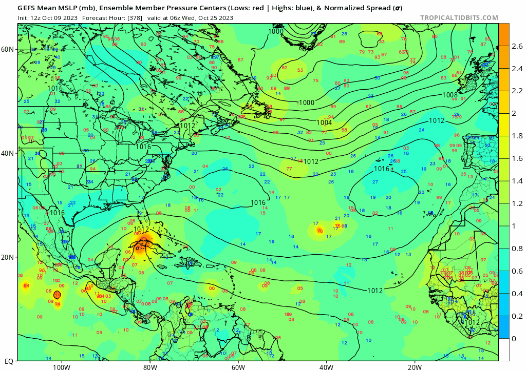
The 12Z GEPS is much more populated than the 00Z run in the Caribbean with action around the 18th and another around the 24th of Oct.
0 likes
Re: 2023 Global Model Runs Discussion (Out thru day 16)
Watch for the strong wave enter the Caribbean in day 9-10 range.
0 likes
Re: 2023 Global Model Runs Discussion (Out thru day 16)
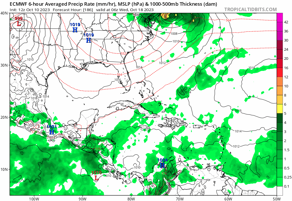
zzzh wrote:Watch for the strong wave enter the Caribbean in day 9-10 range.
Operation Euro shows that wave entering. Fronts coming down so something to watch in the western Caribbean
0 likes
-
SFLcane

- S2K Supporter
- Posts: 10281
- Age: 48
- Joined: Sat Jun 05, 2010 1:44 pm
- Location: Lake Worth Florida
Re: 2023 Global Model Runs Discussion (Out thru day 16)
Im watching the pieces but too much uncertainty still.
0 likes
Re: 2023 Global Model Runs Discussion (Out thru day 16)
SFLcane wrote:Im watching the pieces but too much uncertainty still.
https://i.postimg.cc/bw0RbcqB/IMG-7702.gif
pattern looks troffy for Oct. Anything that makes it far enough west in the Caribbean will get sucked up north. Question is it the Michelle type path or Wilma type path.
0 likes
Who is online
Users browsing this forum: Google [Bot], Google Adsense [Bot], HurricaneFan, JtSmarts and 193 guests