Moderator: S2k Moderators


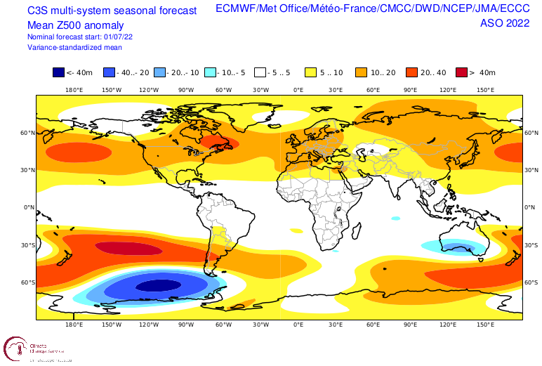
cycloneye wrote:C3S July forecast.
https://twitter.com/dmorris9661/status/1547210445886455814
https://twitter.com/dmorris9661/status/1547210449573265409
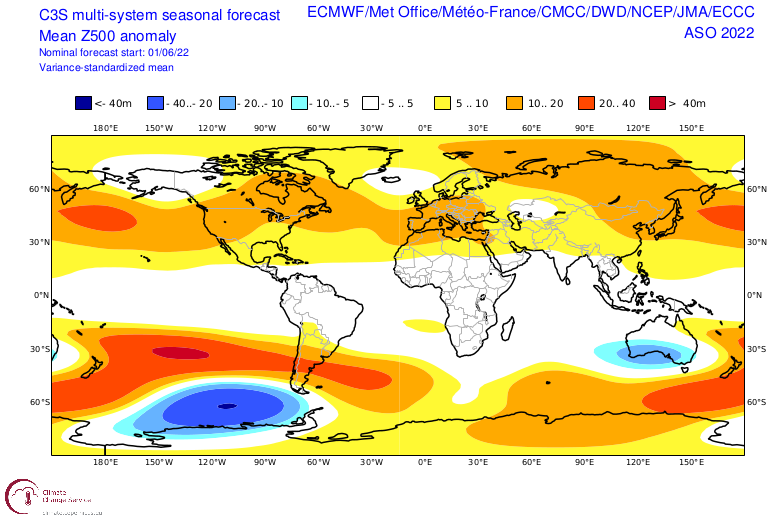
cycloneye wrote:C3S July forecast.
https://twitter.com/dmorris9661/status/1547210445886455814
https://twitter.com/dmorris9661/status/1547210449573265409


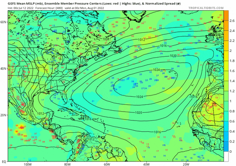
skyline385 wrote:Long-range GEFS lacking in activity to the EPS weeklies
https://media.giphy.com/media/J8dKBhP7QXeLmBCepQ/giphy.gif
Stormybajan wrote:skyline385 wrote:Long-range GEFS lacking in activity to the EPS weeklies
https://media.giphy.com/media/J8dKBhP7QXeLmBCepQ/giphy.gif
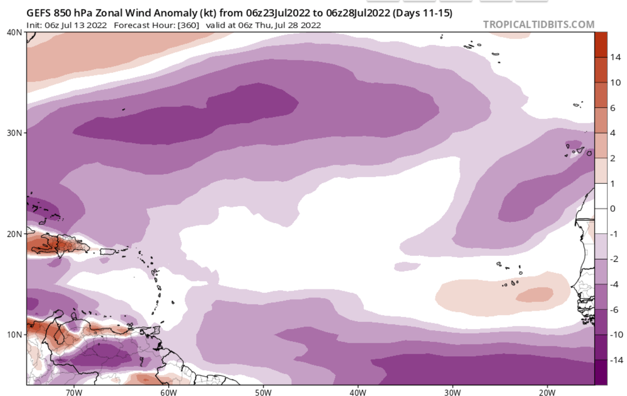
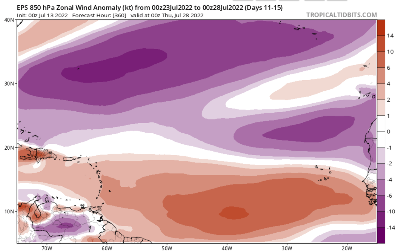
Its definitely very strange seeing the longrange 00z GEFS basically picking up on NOTHING through August 16th, however give it to the end of July the signal definitely will in the uptick because it literally has to (August starts peak season in the Atlantic) . However one theory I have for such inactivity on the July 12 00z run maybe the MJO bias GEFS has? I mean if we were to compare the 850 hPa Zonal Wind anomaly ..its literally night and day between the GEFS and the EPS for the MDR. They should become more aligned July 31st and the models should be sniffing out some activity by then, bet on it.


skyline385 wrote:Stormybajan wrote:skyline385 wrote:Long-range GEFS lacking in activity to the EPS weeklies
https://media.giphy.com/media/J8dKBhP7QXeLmBCepQ/giphy.gif
Its definitely very strange seeing the longrange 00z GEFS basically picking up on NOTHING through August 16th, however give it to the end of July the signal definitely will in the uptick because it literally has to (August starts peak season in the Atlantic) . However one theory I have for such inactivity on the July 12 00z run maybe the MJO bias GEFS has? I mean if we were to compare the 850 hPa Zonal Wind anomaly ..its literally night and day between the GEFS and the EPS for the MDR. They should become more aligned July 31st and the models should be sniffing out some activity by then
https://i.postimg.cc/fyJP59N7/GEFS-Zonal-winds-06z-13-Jul22.png
https://i.postimg.cc/wvB4Tm7K/EPS-Zonal-winds-00z-13-Jul22.png
Yes the GFS isn’t very good with MJO phasing, i am assuming that in a couple of weeks as the MJO starts moving out and the GFS is initialized using it, we will still start seeing activity in the ensembles. This week has been weird for both the EPS and GEFS, particularly the EPS VPot plots.
Blown Away wrote:Modeling/Indicators/Steering, every year it all follows the same cycle below:
May-June: Modeling develops to many early season lows.
Mid July: Storm2k members expect the modeling to begin sniffing the start of the active part of the season and we get crickets.
Mid July - Mid August: Storm2k cancel season posts are raging; Member emotional breakdowns; Modeling is a failure.
Mid August - Mid October: Storm2k members spend all their time now in the Storm2k Active Storms/Invest board tracking systems and are fired up.
Mid October - Nov 30th: Members are exhausted tracking storms.
Dec-May: Cycle begins again.
Every year same thing and of course I'm kidding.


cycloneye wrote:I have not seen for a while in this thread discussion about the West African Monsoon that is one of the key factors that causes a season to be active or not depending on what is the status of it. How is it right now?


weeniepatrol wrote:cycloneye wrote:I have not seen for a while in this thread discussion about the West African Monsoon that is one of the key factors that causes a season to be active or not depending on what is the status of it. How is it right now?
Very strong, regardless of chosen parameter
https://i.imgur.com/Ee44UBU.gif
https://i.imgur.com/LTZX1Pr.gif
https://i.imgur.com/Ime0WJ5.gif
cycloneye wrote:weeniepatrol wrote:cycloneye wrote:I have not seen for a while in this thread discussion about the West African Monsoon that is one of the key factors that causes a season to be active or not depending on what is the status of it. How is it right now?
Very strong, regardless of chosen parameter
https://i.imgur.com/Ee44UBU.gif
https://i.imgur.com/LTZX1Pr.gif
https://i.imgur.com/Ime0WJ5.gif
That means the parade of strong waves will begin soon. Thank you.

Users browsing this forum: pepecool20, Ulf and 240 guests
