
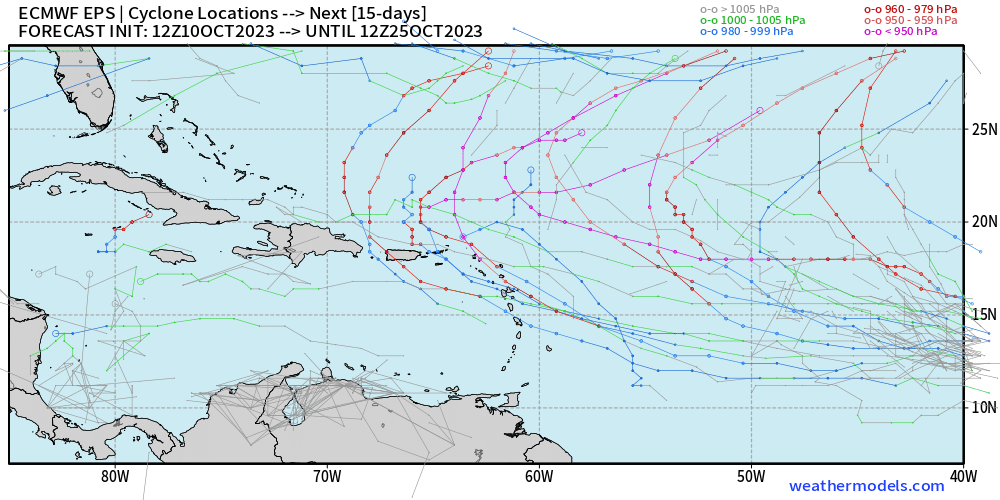
12z EPS. Much stronger signal on the system.
Moderator: S2k Moderators


zzzh wrote:https://i.imgur.com/h7jZSH0.png
12z EPS. Much stronger signal on the system.


zzzh wrote:https://i.imgur.com/h7jZSH0.png
12z EPS. Much stronger signal on the system.

Blown Away wrote:[url]https://i.postimg.cc/W423HzkK/574d0501-a133-4dd5-9314-08c226787843.gif [/url]
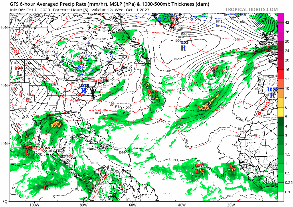
06z GFS... Amazed how many lows continue to swirl in the Central Atlantic.
Ianswfl wrote:Blown Away wrote:[url]https://i.postimg.cc/W423HzkK/574d0501-a133-4dd5-9314-08c226787843.gif [/url]
06z GFS... Amazed how many lows continue to swirl in the Central Atlantic.
The models still think it's mid sept! Better hope the gfs ensembles are right. If the high is any stronger we might have a cv threat around here! Kate 85 hit from thr east in late Nov. Don't say never!
Jr0d wrote:Ianswfl wrote:Blown Away wrote:[url]https://i.postimg.cc/W423HzkK/574d0501-a133-4dd5-9314-08c226787843.gif [/url]
06z GFS... Amazed how many lows continue to swirl in the Central Atlantic.
The models still think it's mid sept! Better hope the gfs ensembles are right. If the high is any stronger we might have a cv threat around here! Kate 85 hit from thr east in late Nov. Don't say never!
The Yankee hurricane of 1935 is an interesting track for a November hurricane too. Never say never!
That said im still keeping an eye on the NW Caribbean. The CMC has dropped the hurricane moving into Florida...however there is certainly a signal from the ensembles with something maybe starting to brew late next week.


Ianswfl wrote:Cat4 into Key West and then Naples.What I was talking about the far southern Gulf and Caribbean will still be warm enough for a fast moving system even after the front.
https://www.tropicaltidbits.com/analysis/models/gfs-ens/2023101200/gfs-ememb_lowlocs_eus_54.png
ElectricStorm wrote:Ianswfl wrote:Cat4 into Key West and then Naples.
https://www.tropicaltidbits.com/analysis/models/gfs-ens/2023101200/gfs-ememb_lowlocs_eus_54.png
Hour 318 though, I wouldn't be concerned about anything yet that's way into fantasy land


Ianswfl wrote:Cat4 into Key West and then Naples.
https://www.tropicaltidbits.com/analysis/models/gfs-ens/2023101200/gfs-ememb_lowlocs_eus_54.png
toad strangler wrote:Models continue to show a stout front that will clear the FL peninsula and usher in the coolest temps and lowest humidity S FL has seen in many months. The 0z Euro doesn’t show even far S FL reaching 80 post front again until late next week. Michael Lowry talks about this and its implications in his latest update… his context is for CONUS only obviously.
South Florida’s first real cold front of fall could signal a tapering off of tropical threats
We’ll be eyeing what looks to be the passage our first real fall cold front through South Florida by Sunday into Monday. Not only will this usher in some refreshingly dry and cooler weather, but it’ll kick us into dry season, a point in hurricane season we begin to see storm threats subside for South Florida. Tropical threats still happen even into November, so don’t toss out your hurricane supplies just yet. That said, making it to dry season without a South Florida hurricane is an important step to closing out hurricane season.
SFLcane wrote:toad strangler wrote:Models continue to show a stout front that will clear the FL peninsula and usher in the coolest temps and lowest humidity S FL has seen in many months. The 0z Euro doesn’t show even far S FL reaching 80 post front again until late next week. Michael Lowry talks about this and its implications in his latest update… his context is for CONUS only obviously.
South Florida’s first real cold front of fall could signal a tapering off of tropical threats
We’ll be eyeing what looks to be the passage our first real fall cold front through South Florida by Sunday into Monday. Not only will this usher in some refreshingly dry and cooler weather, but it’ll kick us into dry season, a point in hurricane season we begin to see storm threats subside for South Florida. Tropical threats still happen even into November, so don’t toss out your hurricane supplies just yet. That said, making it to dry season without a South Florida hurricane is an important step to closing out hurricane season.
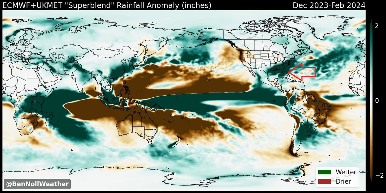
1- Hmmm.. Honestly don't plan on a dry season across the Florida Peninsula we are in for a boat load of rain and likely some severe wx to thanks to the el nino screaming jet in the gulf blowing across the state.
2- Two the door will surely remain open for SFL though october as these fronts can always be potential triggers for something in the caribbean which i will add will stay quite favorable into Nov it looks like.
Here is the ECM/UK superblend.. You cant even make out florida.
https://i.postimg.cc/6Qngz6cS/mmmm.jpg
Now back on topic..


SFLcane wrote:toad strangler wrote:Models continue to show a stout front that will clear the FL peninsula and usher in the coolest temps and lowest humidity S FL has seen in many months. The 0z Euro doesn’t show even far S FL reaching 80 post front again until late next week. Michael Lowry talks about this and its implications in his latest update… his context is for CONUS only obviously.
South Florida’s first real cold front of fall could signal a tapering off of tropical threats
We’ll be eyeing what looks to be the passage our first real fall cold front through South Florida by Sunday into Monday. Not only will this usher in some refreshingly dry and cooler weather, but it’ll kick us into dry season, a point in hurricane season we begin to see storm threats subside for South Florida. Tropical threats still happen even into November, so don’t toss out your hurricane supplies just yet. That said, making it to dry season without a South Florida hurricane is an important step to closing out hurricane season.
1- Hmmm.. Honestly don't plan on a dry season across the Florida Peninsula we are in for a boat load of rain and likely some severe wx to thanks to the el nino screaming jet in the gulf blowing across the state.
2- Two the door will surely remain open for SFL though october as these fronts can always be potential triggers for something in the caribbean which i will add will stay quite favorable into Nov it looks like.
Here is the ECM/UK superblend.. You cant even make out florida.
https://i.postimg.cc/6Qngz6cS/mmmm.jpg
Now back on topic..
ThunderForce wrote:https://i.imgur.com/kGfAjKq.png
12 GEFS Run.
Looks like a slight uptick on Western Caribbean activity that starts around F150 (I see about 4-6 members getting into the Gulf on the current run), but it appears that more ensemble members for 94L start taking a northwestward heading before getting to the Leeward and Windward Islands sooner compared to before.

Users browsing this forum: No registered users and 193 guests

