Today, this thread has gotten very good discussions about some indicators and guess what, here are much more.
https://twitter.com/cyclonicwx/status/1547623614064631809
https://twitter.com/webberweather/status/1547625061275684869
https://twitter.com/AndyHazelton/status/1547625440591851521
https://twitter.com/dmorris9661/status/1547626812938731521
https://twitter.com/TropicalTidbits/status/1547627285129203719
https://twitter.com/AndyHazelton/status/1547627700440797186
https://twitter.com/cyclonicwx/status/1547629834762760193
2022 Indicators (SSTs/SAL/MSLP/Shear/Steering/Instability) and >Day 16 Models
Moderator: S2k Moderators
Forum rules

The posts in this forum are NOT official forecasts and should not be used as such. They are just the opinion of the poster and may or may not be backed by sound meteorological data. They are NOT endorsed by any professional institution or STORM2K. For official information, please refer to products from the National Hurricane Center and National Weather Service.
-
cycloneye

- Admin

- Posts: 149716
- Age: 69
- Joined: Thu Oct 10, 2002 10:54 am
- Location: San Juan, Puerto Rico
Re: 2022 Indicators (SSTs/SAL/MSLP/Shear/Steering/Instability) and >Day 16 Models
3 likes
Visit the Caribbean-Central America Weather Thread where you can find at first post web cams,radars
and observations from Caribbean basin members Click Here
and observations from Caribbean basin members Click Here
-
skyline385

- Category 5

- Posts: 2728
- Age: 35
- Joined: Wed Aug 26, 2020 11:15 pm
- Location: Houston TX
2022 Indicators (SSTs/SAL/MSLP/Shear/Steering/Instability) and >Day 16 Models
Was going to post the same thread, very interesting discussion in it. Lots of uncertainties with the MJO still and whether the strong -IOD will affect the WAM. As Levi mentioned there is potential for the sinking cell extending too far from the east to affect the WAM.
Last edited by skyline385 on Thu Jul 14, 2022 6:58 pm, edited 1 time in total.
2 likes
-
SFLcane

- S2K Supporter

- Posts: 10281
- Age: 48
- Joined: Sat Jun 05, 2010 1:44 pm
- Location: Lake Worth Florida
Re: 2022 Indicators (SSTs/SAL/MSLP/Shear/Steering/Instability) and >Day 16 Models
Not sure what about this season suggests that 1995, 2004, 2005, 2017, or 2020 should be included as analogs? 

0 likes
-
Category5Kaiju

- Category 5
- Posts: 4346
- Joined: Thu Dec 24, 2020 12:45 pm
- Location: Seattle during the summer, Phoenix during the winter
Re: 2022 Indicators (SSTs/SAL/MSLP/Shear/Steering/Instability) and >Day 16 Models
SFLcane wrote:Not sure what about this season suggests that 1995, 2004, 2005, 2017, or 2020 should be included as analogs?
What do they all have in common?
Had 200+ ACE (well, aside from 2020 I suppose).
That's pretty much it. Oh, and at least one major CONUS landfall. But yeah, not exactly sure where he got those years in particular otherwise
0 likes
Unless explicitly stated, all information in my posts is based on my own opinions and observations. Tropical storms and hurricanes can be extremely dangerous. Refer to an accredited weather research agency or meteorologist if you need to make serious decisions regarding an approaching storm.
-
SFLcane
- S2K Supporter
- Posts: 10281
- Age: 48
- Joined: Sat Jun 05, 2010 1:44 pm
- Location: Lake Worth Florida
Re: 2022 Indicators (SSTs/SAL/MSLP/Shear/Steering/Instability) and >Day 16 Models
Yea, lets just crank 10 hurricanes through the caribbean how about no. Sorry not buying all that dryness over the sw atlantic.
https://twitter.com/BenNollWeather/status/1547666389426913280
https://twitter.com/BenNollWeather/status/1547666389426913280
0 likes
-
SFLcane
- S2K Supporter
- Posts: 10281
- Age: 48
- Joined: Sat Jun 05, 2010 1:44 pm
- Location: Lake Worth Florida
Re: 2022 Indicators (SSTs/SAL/MSLP/Shear/Steering/Instability) and >Day 16 Models
SFLcane wrote:Yea, lets just crank 10 hurricanes through the caribbean how about no. Sorry not buying all that dryness over the sw atlantic.
https://twitter.com/BenNollWeather/status/1547666389426913280?s=20&t=J49BNoRBPTyyDkpbRlLIoA
Either a potential bust is coming but no way there isn't that many hurricanes going into the caribbean. Something just does not add up with these climate models.
0 likes
-
captainbarbossa19

- Professional-Met

- Posts: 1094
- Age: 27
- Joined: Wed Aug 21, 2019 11:09 pm
- Location: Beaumont, TX
Re: 2022 Indicators (SSTs/SAL/MSLP/Shear/Steering/Instability) and >Day 16 Models
SFLcane wrote:SFLcane wrote:Yea, lets just crank 10 hurricanes through the caribbean how about no. Sorry not buying all that dryness over the sw atlantic.
https://twitter.com/BenNollWeather/status/1547666389426913280?s=20&t=J49BNoRBPTyyDkpbRlLIoA
Either a potential bust is coming but no way there isn't that many hurricanes going into the caribbean. Something just does not add up with these climate models.
I think the only thing really useful about this map is that the MDR is depicted as being wet. Climate models can pickup on height anomalies, but a storm can easily move north of the Caribbean if the ridge is weaker. Smaller scale features will be more important when something actually forms.
4 likes
-
SFLcane
- S2K Supporter
- Posts: 10281
- Age: 48
- Joined: Sat Jun 05, 2010 1:44 pm
- Location: Lake Worth Florida
Re: 2022 Indicators (SSTs/SAL/MSLP/Shear/Steering/Instability) and >Day 16 Models
Tutt is gone on the new eps weeklies across the sw atl i dont get. It's showing TC development favored in the Pacific through mid August. 
0 likes
-
skyline385
- Category 5
- Posts: 2728
- Age: 35
- Joined: Wed Aug 26, 2020 11:15 pm
- Location: Houston TX
Re: 2022 Indicators (SSTs/SAL/MSLP/Shear/Steering/Instability) and >Day 16 Models
A reminder regarding looking for TUTTs on extended forecasts
https://twitter.com/pppapin/status/1545403605150310402
https://twitter.com/pppapin/status/1545403605150310402
0 likes
-
SFLcane
- S2K Supporter
- Posts: 10281
- Age: 48
- Joined: Sat Jun 05, 2010 1:44 pm
- Location: Lake Worth Florida
Re: 2022 Indicators (SSTs/SAL/MSLP/Shear/Steering/Instability) and >Day 16 Models
The Tutt indeed looks pretty weak. I think everything is just getting pushed into the Pacific.
0 likes
-
skyline385
- Category 5
- Posts: 2728
- Age: 35
- Joined: Wed Aug 26, 2020 11:15 pm
- Location: Houston TX
Re: 2022 Indicators (SSTs/SAL/MSLP/Shear/Steering/Instability) and >Day 16 Models
EPS weeklies still seeing suppressed Atlantic till mid-August


0 likes
-
skyline385
- Category 5
- Posts: 2728
- Age: 35
- Joined: Wed Aug 26, 2020 11:15 pm
- Location: Houston TX
2022 Indicators (SSTs/SAL/MSLP/Shear/Steering/Instability) and >Day 16 Models
SFLcane wrote:The Tutt indeed looks pretty weak. I think everything is just getting pushed into the Pacific.
Yea the EPS is predicting increased activity above climate mean for EPAC in August and combined with the ridging anticipated it does look like everything is getting pushed out.
1 likes
-
cycloneye
- Admin
- Posts: 149716
- Age: 69
- Joined: Thu Oct 10, 2002 10:54 am
- Location: San Juan, Puerto Rico
Re: 2022 Indicators (SSTs/SAL/MSLP/Shear/Steering/Instability) and >Day 16 Models
skyline385 wrote:SFLcane wrote:The Tutt indeed looks pretty weak. I think everything is just getting pushed into the Pacific.
Yea the EPS is predicting increased activity above climate mean for EPAC in August and combined with the ridging anticipated it does look like everything is getting pushed out.
If and that is a big if, that happens, give the ACE crown of 2022 to EPAC.
0 likes
Visit the Caribbean-Central America Weather Thread where you can find at first post web cams,radars
and observations from Caribbean basin members Click Here
and observations from Caribbean basin members Click Here
-
skyline385
- Category 5
- Posts: 2728
- Age: 35
- Joined: Wed Aug 26, 2020 11:15 pm
- Location: Houston TX
Re: 2022 Indicators (SSTs/SAL/MSLP/Shear/Steering/Instability) and >Day 16 Models
cycloneye wrote:skyline385 wrote:SFLcane wrote:The Tutt indeed looks pretty weak. I think everything is just getting pushed into the Pacific.
Yea the EPS is predicting increased activity above climate mean for EPAC in August and combined with the ridging anticipated it does look like everything is getting pushed out.
If and that is a big if, that happens, give the ACE crown of 2022 to EPAC.
Yea that is a big IF but I want it to happen just for the sheer ridiculousness of it, EPAC getting the ACE crown in a strong Nina year.
2 likes
-
skyline385
- Category 5
- Posts: 2728
- Age: 35
- Joined: Wed Aug 26, 2020 11:15 pm
- Location: Houston TX
2022 Indicators (SSTs/SAL/MSLP/Shear/Steering/Instability) and >Day 16 Models
Yea that’s some ridiculous ridging on the weekly, everything is pushed below the Antilles till end of August. This is definitely suspect imo. EPAC still at it because of it.


2 likes
-
cycloneye
- Admin
- Posts: 149716
- Age: 69
- Joined: Thu Oct 10, 2002 10:54 am
- Location: San Juan, Puerto Rico
Re: 2022 Indicators (SSTs/SAL/MSLP/Shear/Steering/Instability) and >Day 16 Models
skyline385 wrote:I guess this needs to be said because it’s not obvious enough, nobody is denying that the Atlantic will go nuts in peak season. My posts above are only me sharing the EPS weeklies and my thoughts on it. These season cancel posts are incredibly frustrating and really add nothing to the discussion here, i thought Mark wanted a serious discussion of the indicators here. If that is not the intent then i will stop posting these.
Yes. All the fellow admins are with this thread not falling to back and forth between members or having season canceled posts and instead, good discussions about the indicators.
2 likes
Visit the Caribbean-Central America Weather Thread where you can find at first post web cams,radars
and observations from Caribbean basin members Click Here
and observations from Caribbean basin members Click Here
-
SFLcane
- S2K Supporter
- Posts: 10281
- Age: 48
- Joined: Sat Jun 05, 2010 1:44 pm
- Location: Lake Worth Florida
Re: 2022 Indicators (SSTs/SAL/MSLP/Shear/Steering/Instability) and >Day 16 Models
Weeklies did back off Pacific MJO at peak so that's interesting.
1 likes
-
Category5Kaiju
- Category 5
- Posts: 4346
- Joined: Thu Dec 24, 2020 12:45 pm
- Location: Seattle during the summer, Phoenix during the winter
Re: 2022 Indicators (SSTs/SAL/MSLP/Shear/Steering/Instability) and >Day 16 Models
I think a good question to ask would be why the EPS thinks all of the moisture/waves would be shoved into the EPAC and not the Atlantic? Is ridging simply that strong or is it something else? Iirc last year, we had a similar issue near the end of the season, but that was mainly thanks to the potent Atlantic Nino that focused the ITCZ southward. Doesn't look like we have an Atlantic Nino this time, let alone a warmer than normal Gulf of Guinea.
1 likes
Unless explicitly stated, all information in my posts is based on my own opinions and observations. Tropical storms and hurricanes can be extremely dangerous. Refer to an accredited weather research agency or meteorologist if you need to make serious decisions regarding an approaching storm.
-
weeniepatrol

- Category 5
- Posts: 1345
- Joined: Sat Aug 22, 2020 5:30 pm
- Location: WA State
Re: 2022 Indicators (SSTs/SAL/MSLP/Shear/Steering/Instability) and >Day 16 Models
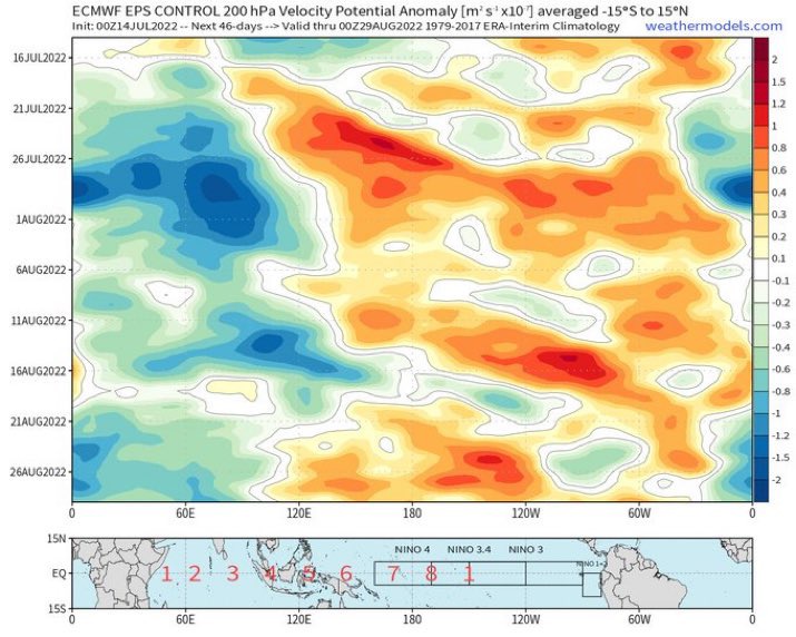
VP200a are the most favorable in the last decade excluding 2021, but this explained by the suppressed MJO overhead the basin since July. Per the EPS, it will be replaced by the active phase around month's end. GFS erroneously handling intraseasonal forcing has already been discussed previously. Very favorable look
2010

2011

2012

2013

2014

2015

2016

2017

2018

2019

2020

2021

2022

July 2022


2010
2011
2012
2013
2014
2015
2016
2017
2018
2019
2020
2021
2022
July 2022
5 likes
Who is online
Users browsing this forum: Google [Bot], Ulf and 161 guests