2023 Global Model Runs Discussion (Out thru day 16)
Moderator: S2k Moderators
Forum rules

The posts in this forum are NOT official forecasts and should not be used as such. They are just the opinion of the poster and may or may not be backed by sound meteorological data. They are NOT endorsed by any professional institution or STORM2K. For official information, please refer to products from the National Hurricane Center and National Weather Service.
Re: 2023 Global Model Runs Discussion (Out thru day 16)
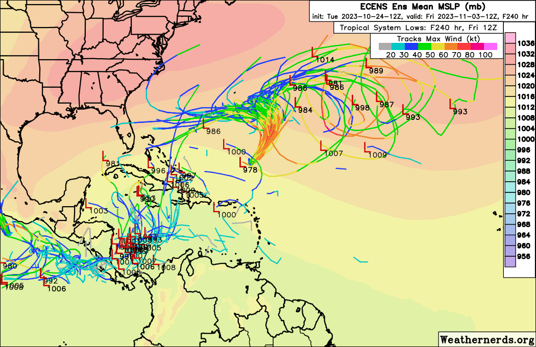
12Z EC shows a strong wave entering the Caribbean in day ~10 range. Environment looks very favorable.
0 likes
Re: 2023 Global Model Runs Discussion (Out thru day 16)
zzzh wrote:12Z EC shows a strong wave entering the Caribbean in day ~10 range. Environment looks very favorable.
Here in SWFL also getting back into a warmer pattern again so anything that forms north of Haiti or the Islands like last night gets pushed west possibly.
The 18z short range euro ensemble run is more west than 12z. Ends at 144 though. That's seperate from Tammy. Euro had it yesterday afternoon. Looked kinda sub tropical though. The longer range 12z had a couple cat1 members hitting south FL.
https://weather.us/cyclone-tracks/euro/ ... 8-240.html
0 likes
-
tolakram
- Admin

- Posts: 20186
- Age: 62
- Joined: Sun Aug 27, 2006 8:23 pm
- Location: Florence, KY (name is Mark)
Re: 2023 Global Model Runs Discussion (Out thru day 16)
Ianswfl wrote:zzzh wrote:12Z EC shows a strong wave entering the Caribbean in day ~10 range. Environment looks very favorable.
Here in SWFL also getting back into a warmer pattern again so anything that forms north of Haiti or the Islands like last night gets pushed west possibly.
The 18z short range euro ensemble run is more west than 12z. Ends at 144 though. That's seperate from Tammy. Euro had it yesterday afternoon. Looked kinda sub tropical though. The longer range 12z had a couple cat1 members hitting south FL.
https://weather.us/cyclone-tracks/euro/ ... 8-240.html
You're using the ensembles wrong. Look for groupings, and past 120 hours there has to be even more extreme grouping before anything is an actual event that might happen. Take the latest EPS. This is why the NHC tagged that area. Look at all the low centers at 78 hours.

That's it, that's the last usable indication on the 0Z run. The further you go out the MORE low centers in the same area you want to see. It's not appropriate to show a few members at 200 hours and call it anything. It's nothing.
12 likes
M a r k
- - - - -
Join us in chat: Storm2K Chatroom Invite. Android and IOS apps also available.
The posts in this forum are NOT official forecasts and should not be used as such. Posts are NOT endorsed by any professional institution or STORM2K.org. For official information and forecasts, please refer to NHC and NWS products.
-
SFLcane

- S2K Supporter

- Posts: 10281
- Age: 48
- Joined: Sat Jun 05, 2010 1:44 pm
- Location: Lake Worth Florida
Re: 2023 Global Model Runs Discussion (Out thru day 16)
tolakram wrote:Ianswfl wrote:zzzh wrote:12Z EC shows a strong wave entering the Caribbean in day ~10 range. Environment looks very favorable.
Here in SWFL also getting back into a warmer pattern again so anything that forms north of Haiti or the Islands like last night gets pushed west possibly.
The 18z short range euro ensemble run is more west than 12z. Ends at 144 though. That's seperate from Tammy. Euro had it yesterday afternoon. Looked kinda sub tropical though. The longer range 12z had a couple cat1 members hitting south FL.
https://weather.us/cyclone-tracks/euro/ ... 8-240.html
You're using the ensembles wrong. Look for groupings, and past 120 hours there has to be even more extreme grouping before anything is an actual event that might happen. Take the latest EPS. This is why the NHC tagged that area. Look at all the low centers at 78 hours.
https://i.imgur.com/rBKuqd1.png
That's it, that's the last usable indication on the 0Z run. The further you go out the MORE low centers in the same area you want to see. It's not appropriate to show a few members at 200 hours and call it anything. It's nothing.
This! In any typical run you can always have your few rogue members.
5 likes
-
jlauderdal
- S2K Supporter
- Posts: 7240
- Joined: Wed May 19, 2004 5:46 am
- Location: NE Fort Lauderdale
- Contact:
Re: RE: Re: 2023 Global Model Runs Discussion (Out thru day 16)
SFLcane wrote:tolakram wrote:Ianswfl wrote:
Here in SWFL also getting back into a warmer pattern again so anything that forms north of Haiti or the Islands like last night gets pushed west possibly.
The 18z short range euro ensemble run is more west than 12z. Ends at 144 though. That's seperate from Tammy. Euro had it yesterday afternoon. Looked kinda sub tropical though. The longer range 12z had a couple cat1 members hitting south FL.
https://weather.us/cyclone-tracks/euro/ ... 8-240.html
You're using the ensembles wrong. Look for groupings, and past 120 hours there has to be even more extreme grouping before anything is an actual event that might happen. Take the latest EPS. This is why the NHC tagged that area. Look at all the low centers at 78 hours.
https://i.imgur.com/rBKuqd1.png
That's it, that's the last usable indication on the 0Z run. The further you go out the MORE low centers in the same area you want to see. It's not appropriate to show a few members at 200 hours and call it anything. It's nothing.
This! In any typical run you can always have your few rogue members.
The rogue members into swfl get way more attention than they should.
8 likes
-
cycloneye

- Admin
- Posts: 149688
- Age: 69
- Joined: Thu Oct 10, 2002 10:54 am
- Location: San Juan, Puerto Rico
Re: RE: Re: 2023 Global Model Runs Discussion (Out thru day 16)
jlauderdal wrote:SFLcane wrote:tolakram wrote:
You're using the ensembles wrong. Look for groupings, and past 120 hours there has to be even more extreme grouping before anything is an actual event that might happen. Take the latest EPS. This is why the NHC tagged that area. Look at all the low centers at 78 hours.
https://i.imgur.com/rBKuqd1.png
That's it, that's the last usable indication on the 0Z run. The further you go out the MORE low centers in the same area you want to see. It's not appropriate to show a few members at 200 hours and call it anything. It's nothing.
This! In any typical run you can always have your few rogue members.
The rogue members into swfl get way more attention than they should.
Bingo for that.
5 likes
Visit the Caribbean-Central America Weather Thread where you can find at first post web cams,radars
and observations from Caribbean basin members Click Here
and observations from Caribbean basin members Click Here
Re: 2023 Global Model Runs Discussion (Out thru day 16)
12z GEM shows AEW development in the Caribbean, EC also shows the wave. GFS has the wave turning north before entering the Caribbean.
0 likes
-
ouragans

- Category 2

- Posts: 501
- Age: 54
- Joined: Sun Jun 12, 2011 12:09 pm
- Location: Abymes, Guadeloupe F.W.I
- Contact:
Re: 2023 Global Model Runs Discussion (Out thru day 16)
Very long rage 6z GFS has a solid cat.3 hitting the Leeward from the Caribbean at day 13. I think I need to back to bed 
0 likes
Personal forecast disclaimer
This post is a personal point of view, not an information. Please refer to official statements for life-threatening decisions.
David '79, Frederic '79, Hugo '89, Iris, Luis & Marilyn '95, Georges '98, Lenny '99, Dean '07, Irma '17, Maria '17, Fiona '22, Philippe '23, Tammy '23
16°13'33.3,"6N -61°36'39.5"W
-
AtlanticWind

- S2K Supporter
- Posts: 1898
- Age: 67
- Joined: Sun Aug 08, 2004 9:57 pm
- Location: Plantation,Fla
Re: 2023 Global Model Runs Discussion (Out thru day 16)
12 z Gfs shows Cat 4 near eastern Cuba in long range
1 likes
-
SFLcane
- S2K Supporter
- Posts: 10281
- Age: 48
- Joined: Sat Jun 05, 2010 1:44 pm
- Location: Lake Worth Florida
Re: 2023 Global Model Runs Discussion (Out thru day 16)
AtlanticWind wrote:12 z Gfs shows Cat 4 near eastern Cuba in long range
https://twitter.com/AndyHazelton/status/1716870569302634578
3 likes
-
Weathertracker96
- Tropical Storm

- Posts: 150
- Joined: Mon Oct 16, 2023 3:41 pm
Re: 2023 Global Model Runs Discussion (Out thru day 16)
I’ve looked at models but I had a quick question, is their a wave or crossover system that may jumpstart this potential Caribbean disturbance?
I also know steering is hard to forecast far in advance but *If* a system were to form, the fronts/troughs that saved majority of areas from landfalls may actually cause problems this time around.
I also know steering is hard to forecast far in advance but *If* a system were to form, the fronts/troughs that saved majority of areas from landfalls may actually cause problems this time around.
0 likes

-
DunedinDave
- Category 1

- Posts: 269
- Joined: Fri Aug 25, 2023 10:31 am
Re: 2023 Global Model Runs Discussion (Out thru day 16)
Looks like that GFS cat 4 storm 12z was just a happy hour run. They got hammered early today. Back to nothing but a weak low at 18z…which is usually when their happy hour runs are.
0 likes
Re: 2023 Global Model Runs Discussion (Out thru day 16)
All models show monsoon gyre like stuff in the Caribbean, it's hard to predict what will come out of it especially when it will interact with tropical waves.
By the way, you typically see those monsoon gyres in WPAC during summer, not in the Caribbean
By the way, you typically see those monsoon gyres in WPAC during summer, not in the Caribbean
2 likes

Re: 2023 Global Model Runs Discussion (Out thru day 16)
It's a happy hour special on the Euro Ensembles for Florida from the East and the South.

1 likes
The following post is NOT an official forecast and should not be used as such. It is just the opinion of the poster and may or may not be backed by sound meteorological data. It is NOT endorsed by any professional institution including storm2k.org For Official Information please refer to the NHC and NWS products.
-
AutoPenalti
- Category 5

- Posts: 4091
- Age: 29
- Joined: Mon Aug 17, 2015 4:16 pm
- Location: Ft. Lauderdale, Florida
Re: 2023 Global Model Runs Discussion (Out thru day 16)
blp wrote:It's a happy hour special on the Euro Ensembles for Florida from the East and the South.
https://i.ibb.co/sjKsS9m/73906990.gif
That collision course is lighting in a bottle lol.
1 likes
The posts in this forum are NOT official forecasts and should not be used as such. They are just the opinion of the poster and may or may not be backed by sound meteorological data. They are NOT endorsed by any professional institution or STORM2K. For official information, please refer to products from the NHC and NWS.
Model Runs Cheat Sheet:
GFS (5:30 AM/PM, 11:30 AM/PM)
HWRF, GFDL, UKMET, NAVGEM (6:30-8:00 AM/PM, 12:30-2:00 AM/PM)
ECMWF (1:45 AM/PM)
TCVN is a weighted averaged

Re: 2023 Global Model Runs Discussion (Out thru day 16)
There have been 9 category 5 cyclones globally so far this year. We're only behind 2014 (10), 2018 (11) and 1997 (12) in that metric.
2 likes


Re: 2023 Global Model Runs Discussion (Out thru day 16)
Everyone seems to have had it with this season, goofy model runs, phantoms. Unfortunately it is dragging on.
1 likes
-
Hypercane_Kyle

- Category 5
- Posts: 3465
- Joined: Sat Mar 07, 2015 7:58 pm
- Location: Cape Canaveral, FL
Re: 2023 Global Model Runs Discussion (Out thru day 16)
18z GFS has a pretty violent hurricane in the Caribbean by 11 days.
0 likes
My posts are my own personal opinion, defer to the National Hurricane Center (NHC) and other NOAA products for decision making during hurricane season.
Who is online
Users browsing this forum: No registered users and 227 guests