2024 Global Model Runs Discussion (Out thru day 16)

This is the general tropical discussion area. Anyone can take their shot at predicting a storms path.

Moderator: S2k Moderators

Forum rules

The posts in this forum are NOT official forecasts and should not be used as such. They are just the opinion of the poster and may or may not be backed by sound meteorological data. They are NOT endorsed by any professional institution or STORM2K. For official information, please refer to products from the National Hurricane Center and National Weather Service.

Help Support Storm2K
Message
Author
User avatar
Ubuntwo
Category 5
Category 5
Posts: 1406
Age: 31
Joined: Thu Oct 05, 2017 10:41 pm

Re: 2024 Global Model Runs Discussion (Out thru day 16)

#1761 Postby Ubuntwo » Sat Sep 07, 2024 12:34 pm

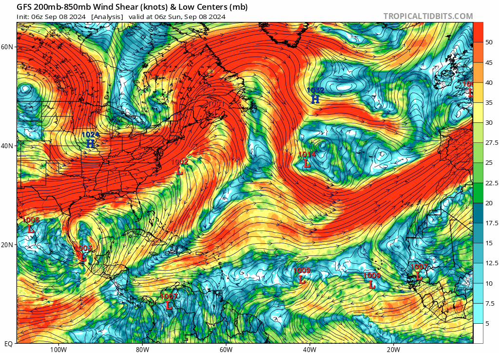
cheezyWXguy wrote:If there’s anything I can gather from looking at all these runs, it’s the models are depicting several areas of low pressure forming from the monsoon trough and/or its interactions with passing tropical waves, and it they are struggling to resolve a singular outcome. Pick a run at random and it’s a different vort that becomes dominant, and the erratic tracks seem to due in part to fujiwara interactions with the less dominant vorts. Reminds me a lot of Rene and Paulette back in 2020. Until something consolidates I don’t think we’re going to have much of an idea on track/intensity

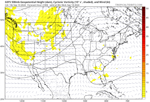
Yep, the complex nature of the breakdown with the additional 'fun' factor of the tropical wave expected to roll off Africa in a few days makes this a challenging forecast. The ICON has consistently shown this breaking down into three main vorts with closed lows - a three body problem would have us running blind. Uncertainty is well above average.
0 likes   
Kendall -> SLO -> PBC

Memorable Storms: Katrina (for its Florida landfall...) Wilma Matthew Irma

User avatar
skyline385
Category 5
Category 5
Posts: 2728
Age: 35
Joined: Wed Aug 26, 2020 11:15 pm
Location: Houston TX

Re: 2024 Global Model Runs Discussion (Out thru day 16)

#1762 Postby skyline385 » Sat Sep 07, 2024 2:15 pm

very active EPS from the monsoon trough breakdown which has been uptrending on all models

Image
2 likes   

User avatar
MetroMike
Category 4
Category 4
Posts: 952
Joined: Sun Aug 29, 2004 8:13 pm
Location: Tampa Bay
Contact:

Re: 2024 Global Model Runs Discussion (Out thru day 16)

#1763 Postby MetroMike » Sat Sep 07, 2024 2:56 pm

The 12Z EC-fast is on board with a MH it appears in the central Atl. moving more west near the end. Not North like the GFS.
1 likes   

otowntiger
Category 5
Category 5
Posts: 1921
Joined: Tue Aug 31, 2004 7:06 pm

Re: 2024 Global Model Runs Discussion (Out thru day 16)

#1764 Postby otowntiger » Sat Sep 07, 2024 3:13 pm

skyline385 wrote:very active EPS from the monsoon trough breakdown which has been uptrending on all models

https://i.imgur.com/RVziuZH.png

Amazing how utterly non existent the Bermuda high is so far this season. Everything predicted before the season has turned out to be the opposite, except for the hot water- which hasn’t so far meant anything.
2 likes   

Cachondo23
Tropical Depression
Tropical Depression
Posts: 75
Joined: Wed May 25, 2022 5:56 am

Re: 2024 Global Model Runs Discussion (Out thru day 16)

#1765 Postby Cachondo23 » Sat Sep 07, 2024 3:27 pm

otowntiger wrote:
skyline385 wrote:very active EPS from the monsoon trough breakdown which has been uptrending on all models

https://i.imgur.com/RVziuZH.png

Amazing how utterly non existent the Bermuda high is so far this season. Everything predicted before the season has turned out to be the opposite, except for the hot water- which hasn’t so far meant anything.

I believe the warm waters, among other factors, was the cause of Beryl exploding before reaching The Grenadines and getting up to Cat 5 south of PR and La Hispaniola.
1 likes   

otowntiger
Category 5
Category 5
Posts: 1921
Joined: Tue Aug 31, 2004 7:06 pm

Re: 2024 Global Model Runs Discussion (Out thru day 16)

#1766 Postby otowntiger » Sat Sep 07, 2024 3:33 pm

Cachondo23 wrote:
otowntiger wrote:
skyline385 wrote:very active EPS from the monsoon trough breakdown which has been uptrending on all models

https://i.imgur.com/RVziuZH.png

Amazing how utterly non existent the Bermuda high is so far this season. Everything predicted before the season has turned out to be the opposite, except for the hot water- which hasn’t so far meant anything.

I believe the warm waters, among other factors, was the cause of Beryl exploding before reaching The Grenadines and getting up to Cat 5 south of PR and La Hispaniola.

Of course. Of course. Other than the very anomalous Beryl.
0 likes   

User avatar
mitchell
Category 1
Category 1
Posts: 408
Joined: Wed Mar 19, 2003 8:22 am
Location: Delaware
Contact:

Re: 2024 Global Model Runs Discussion (Out thru day 16)

#1767 Postby mitchell » Sat Sep 07, 2024 8:46 pm

The 18z GFS is always good for something to stare at and marvel and today's 18z GFS didn't disappoint!
Image
2 likes   

User avatar
Hammy
Category 5
Category 5
Posts: 5849
Age: 41
Joined: Fri May 25, 2012 5:25 pm
Contact:

Re: 2024 Global Model Runs Discussion (Out thru day 16)

#1768 Postby Hammy » Sat Sep 07, 2024 11:03 pm

GFS really seems to be struggling with the monsoon interaction in determining which of the two MDR waves develops first, it's been flipping back and forth now for several consecutive runs

Meanwhile looks like the monsoon shenanigans are still very much present, Canadian strings out the next wave and shoots the one after almost straight north
Image
Image
Image
0 likes   
The above post is not official and should not be used as such. It is the opinion of the poster and may or may not be backed by sound meteorological data. It is not endorsed by any professional institution or storm2k.org. For official information, please refer to the NHC and NWS products.

otowntiger
Category 5
Category 5
Posts: 1921
Joined: Tue Aug 31, 2004 7:06 pm

Re: 2024 Global Model Runs Discussion (Out thru day 16)

#1769 Postby otowntiger » Sun Sep 08, 2024 6:30 am

Wow! other than the gulf tropical storm next week the gfs now showing hostile conditions across the entire basin thru nearly the end of September- nothing develops! What a weird season- again we go from dire doom and gloom record activity predicted to this in the heart of the season.
0 likes   

Weathertracker96
Tropical Storm
Tropical Storm
Posts: 104
Joined: Mon Oct 16, 2023 3:41 pm

Re: 2024 Global Model Runs Discussion (Out thru day 16)

#1770 Postby Weathertracker96 » Sun Sep 08, 2024 6:39 am

otowntiger wrote:Wow! other than the gulf tropical storm next week the gfs now showing hostile conditions across the entire basin thru nearly the end of September- nothing develops! What a weird season- again we go from dire doom and gloom record activity predicted to this in the heart of the season.


And it can easily go back to showing tropical systems. We have two invests out there already. Things can change run to run.
Last edited by Weathertracker96 on Sun Sep 08, 2024 7:23 am, edited 1 time in total.
1 likes   

caneman
Category 5
Category 5
Posts: 1447
Joined: Fri Sep 05, 2014 5:44 am
Location: Clearwater Beach, Fl

Re: 2024 Global Model Runs Discussion (Out thru day 16)

#1771 Postby caneman » Sun Sep 08, 2024 6:57 am

otowntiger wrote:Wow! other than the gulf tropical storm next week the gfs now showing hostile conditions across the entire basin thru nearly the end of September- nothing develops! What a weird season- again we go from dire doom and gloom record activity predicted to this in the heart of the season.


Models are mostly out to lunch and can't seem to figure this pattern out so I'm going to stick to now casting. Lol.
1 likes   

User avatar
gatorcane
S2K Supporter
S2K Supporter
Posts: 23691
Age: 47
Joined: Sun Mar 13, 2005 3:54 pm
Location: Boca Raton, FL

Re: 2024 Global Model Runs Discussion (Out thru day 16)

#1772 Postby gatorcane » Sun Sep 08, 2024 7:00 am

otowntiger wrote:Wow! other than the gulf tropical storm next week the gfs now showing hostile conditions across the entire basin thru nearly the end of September- nothing develops! What a weird season- again we go from dire doom and gloom record activity predicted to this in the heart of the season.

Also the CMC looks similar to the GFS as far as no significant development. Here is the GFS shear forecast over the next 7 days, doesn't look particularly favorable with one TUTT shearing the west system and another upper-low shearing the east system. That said the ensembles look bullish, so leaning towards development of at least one of these systems.

Image
0 likes   

WeatherBoy2000
Category 1
Category 1
Posts: 346
Joined: Mon Apr 10, 2023 9:29 am

Re: 2024 Global Model Runs Discussion (Out thru day 16)

#1773 Postby WeatherBoy2000 » Sun Sep 08, 2024 8:02 am

At this range ensembles are typically more useful than operationals. Even with a strong ensemble signal there might be an operational run or two that doesn't develop. Gotta watch if non-development continues on future runs paired with weakening support in general.
0 likes   

User avatar
Category5Kaiju
Category 5
Category 5
Posts: 4095
Joined: Thu Dec 24, 2020 12:45 pm
Location: Seattle

Re: 2024 Global Model Runs Discussion (Out thru day 16)

#1774 Postby Category5Kaiju » Tue Sep 10, 2024 6:38 pm

This is the second GFS run in a row that develops a rapidly-forming eastern MDR system at the end of this month (third if you count the feature's presence itself). While it's way to early to know if this is a phantom, it does beg the question of whether this season may be in the works of trying to produce late-season Cape Verde activity, with the very warm waters and active wave train especially.
4 likes   
Unless explicitly stated, all info in my posts is based on my own opinions and observations. Tropical storms and hurricanes can be extremely dangerous. Do not think you can beat Mother Nature. Refer to an accredited weather research agency or meteorologist if you need to make serious decisions regarding an approaching storm.

Stormlover70
Tropical Storm
Tropical Storm
Posts: 175
Age: 55
Joined: Fri Jun 21, 2024 5:31 am
Location: New port richey

Re: 2024 Global Model Runs Discussion (Out thru day 16)

#1775 Postby Stormlover70 » Tue Sep 10, 2024 7:08 pm

I am looking east with baited breath. I fear mother nature is about to rear her ugly head.
0 likes   

TomballEd
Category 2
Category 2
Posts: 692
Age: 61
Joined: Wed Aug 16, 2023 4:52 pm
Location: Spring/Klein area, not Tomball

Re: 2024 Global Model Runs Discussion (Out thru day 16)

#1776 Postby TomballEd » Tue Sep 10, 2024 10:14 pm

I was wondering if Francine's track NE was a sign of a temporary thing, or the season in Texas ending 2 weeks before the normal end date of the Equinox. There have been 2 October hurricanes, but usually the equinox means hurricane season is over. But the Westerlies will be blowing over Texas for the next 15 days per ensembles (OK, some N-lies and even NE-lies in the ensemble means). Not trying to tempt the fates into dropping another hurricane on us, just noting the models.

. There is always 1949, with an October Cat 2 near Freeport which may have been as strong as a Cat 4 in the Gulf, a system that crossed into the Atlantic basin from the Pacific, and, of course, Hurricane Jerry, the same weekend I was at the Cottn Bowl watching Texas beat OU. The Equinox is only the unofficial end of hurricane season here. Except it came 2 weeks early.
Plenty to watch in the Gulf still, Michael was a Cat 5 in October. But I'm feeling pretty good not buying a generator this summer after 5 days in DFW to have air conditioning and CPAP. That cost well over $1000. 3 months to ice storm season. When I may wish I had bought a generator after all.


Image
0 likes   

User avatar
REDHurricane
Category 1
Category 1
Posts: 396
Age: 27
Joined: Sun Jul 03, 2022 2:36 pm
Location: Northeast Pacific Ocean

Re: 2024 Global Model Runs Discussion (Out thru day 16)

#1777 Postby REDHurricane » Wed Sep 11, 2024 12:26 am

Category5Kaiju wrote:This is the second GFS run in a row that develops a rapidly-forming eastern MDR system at the end of this month (third if you count the feature's presence itself). While it's way to early to know if this is a phantom, it does beg the question of whether this season may be in the works of trying to produce late-season Cape Verde activity, with the very warm waters and active wave train especially.


I've been saying it all along, if the primary reason behind the lack of any MDR activity since mid-August has actually been the extreme northern displacement of the WAM, then it seems logical that typical peak season MDR activity will resume once the WAM moves south back to its typical peak season latitude. I really think that people are paying too much attention to climatology (despite how reliable it's been in the past) right now when predicting how the rest of the season will go -- when conditions are this anomalous (WAM, AEJ, SSTs, OHC, etc.) basin-wide, it doesn't necessarily make sense to expect that the Atlantic will follow the same calendar-based pattern as it usually does. Just getting that feeling that the next few months (or even weeks) might have more than a handful of surprises in store for everyone who's been unironically season cancelling the past couple of weeks... so yeah, it wouldn't surprise me in the least if both of the 2 current AOIs (including 93L) fail to meet expectations (or even develop at all) but a resurgence of activity still ends up bursting onto the scene over the last 10-14 days of the month
5 likes   

User avatar
Category5Kaiju
Category 5
Category 5
Posts: 4095
Joined: Thu Dec 24, 2020 12:45 pm
Location: Seattle

Re: 2024 Global Model Runs Discussion (Out thru day 16)

#1778 Postby Category5Kaiju » Wed Sep 11, 2024 7:21 am

That's now 5 GFS runs in a row that form the eastern MDR system by the month's end, generally heading in a westward direction (6z came in very weak, but it seems to still be a traceable feature).

As an fun sidenote, assuming none of the current lemons in the MDR form, assuming the red AOI in the MDR and the southeastern US coast system develop, and assuming we get no pop-up storms going forward otherwise, should this advertised system form, it'll receive....yup, that's right. The I name. :lol:
2 likes   
Unless explicitly stated, all info in my posts is based on my own opinions and observations. Tropical storms and hurricanes can be extremely dangerous. Do not think you can beat Mother Nature. Refer to an accredited weather research agency or meteorologist if you need to make serious decisions regarding an approaching storm.

User avatar
Teban54
Category 5
Category 5
Posts: 3204
Joined: Sat May 19, 2018 1:19 pm

Re: 2024 Global Model Runs Discussion (Out thru day 16)

#1779 Postby Teban54 » Wed Sep 11, 2024 12:29 pm

Category5Kaiju wrote:That's now 5 GFS runs in a row that form the eastern MDR system by the month's end, generally heading in a westward direction (6z came in very weak, but it seems to still be a traceable feature).

As an fun sidenote, assuming none of the current lemons in the MDR form, assuming the red AOI in the MDR and the southeastern US coast system develop, and assuming we get no pop-up storms going forward otherwise, should this advertised system form, it'll receive....yup, that's right. The I name. :lol:

12z GFS still has a traceable piece of vorticity, but doesn't seem to develop it to a TC just like 6z.

But hey, if GFS can't see the formation of TD 7 just 3 hours in advance, how confident are we about the formation of another Eastern Atlantic system 384 hours in advance? :lol:
2 likes   

Stratton23
Category 5
Category 5
Posts: 2519
Joined: Fri Jul 21, 2023 10:59 pm
Location: Katy, Tx

Re: 2024 Global Model Runs Discussion (Out thru day 16)

#1780 Postby Stratton23 » Wed Sep 11, 2024 11:45 pm

00z CMC hints at the CAG becoming active in about 10 days
0 likes   


Return to “Talkin' Tropics”

Who is online

Users browsing this forum: ElectricStorm, Google Adsense [Bot], hurricanes1234, IsabelaWeather and 37 guests