
https://x.com/webberweather/status/1823366056791937392
https://x.com/dmorris9661/status/1823380980956045611
2024 Indicators: SST's, MSLP, Shear, SAL, Steering, Instability (Day 16+ Climate Models)
Moderator: S2k Moderators
Forum rules

The posts in this forum are NOT official forecasts and should not be used as such. They are just the opinion of the poster and may or may not be backed by sound meteorological data. They are NOT endorsed by any professional institution or STORM2K. For official information, please refer to products from the National Hurricane Center and National Weather Service.
Re: 2024 Indicators: SST's, MSLP, Shear, SAL, Steering, Instability (Day 16+ Climate Models)
Since most of us (including me) are expecting a hyperactive season, can someone make a climatology with only hyperactive years and compare 2024 to it?
0 likes

Re: 2024 Indicators: SST's, MSLP, Shear, SAL, Steering, Instability (Day 16+ Climate Models)
Emmett_Brown wrote:
Sure, maybe waves are coming off further N, which means they might not develop right away. But we can't assume that these waves won't eventually develop, and the further W they develop, the more they could threaten land. Look at Debby... it started as a large SAL choked wave that extended very far N and S, and inevitably moistened up and developed when it was already near land. So this could explain why models don't see development, but it certainly doesn't mean the models are right... the development is likely just delayed but inevitable. This could be a season where the bulk of cyclogenesis happens with less lead time.
This is a key reason why I'm not expecting the eastern half of the MDR to be that active--most storms that do develop that far east, seem to come off around 8-12N. Something else I've noticed, I wonder if the monsoon trough is simply too strong for the next week or so--some of the waves appear to be sucked back into it as they exit, something we don't see very often (and something that often heralds larger, stronger waves once it breaks up)
1 likes
The above post is not official and should not be used as such. It is the opinion of the poster and may or may not be backed by sound meteorological data. It is not endorsed by any professional institution or storm2k.org. For official information, please refer to the NHC and NWS products.
-
CyclonicFury

- Category 5

- Posts: 2032
- Age: 27
- Joined: Sun Jul 02, 2017 12:32 pm
- Location: NC
- Contact:
Re: 2024 Indicators: SST's, MSLP, Shear, SAL, Steering, Instability (Day 16+ Climate Models)
Hammy wrote:Emmett_Brown wrote:
Sure, maybe waves are coming off further N, which means they might not develop right away. But we can't assume that these waves won't eventually develop, and the further W they develop, the more they could threaten land. Look at Debby... it started as a large SAL choked wave that extended very far N and S, and inevitably moistened up and developed when it was already near land. So this could explain why models don't see development, but it certainly doesn't mean the models are right... the development is likely just delayed but inevitable. This could be a season where the bulk of cyclogenesis happens with less lead time.
This is a key reason why I'm not expecting the eastern half of the MDR to be that active--most storms that do develop that far east, seem to come off around 8-12N. Something else I've noticed, I wonder if the monsoon trough is simply too strong for the next week or so--some of the waves appear to be sucked back into it as they exit, something we don't see very often (and something that often heralds larger, stronger waves once it breaks up)
In recent years we haven't seen intense MDR activity during the month of August. In fact, since 2018, the Atlantic has produced 3 MDR hurricanes before August, but none during August. Most of the recent August MDR activity has been farther west, forming right near the Lesser Antilles. In recent years, we've also seen the MDR remain somewhat favorable into October, which is fascinating.
The most favorable window for classic Cape Verde hurricanes in recent years has seemingly been mid-September, though by that late in the season, they are much more likely to recurve. Compared to August, the waves come off farther south, SAL is less prevalent, and SSTs are warmer in September. Though, it does appear by the middle of September the MJO pattern won't be quite as favorable for the Atlantic.
2 likes
NCSU B.S. in Meteorology Class of 2021. Tropical weather blogger at http://www.cyclonicfury.com. My forecasts and thoughts are NOT official, for official forecasts please consult the National Hurricane Center.
-
SFLcane

- S2K Supporter

- Posts: 10281
- Age: 48
- Joined: Sat Jun 05, 2010 1:44 pm
- Location: Lake Worth Florida
Re: 2024 Indicators: SST's, MSLP, Shear, SAL, Steering, Instability (Day 16+ Climate Models)
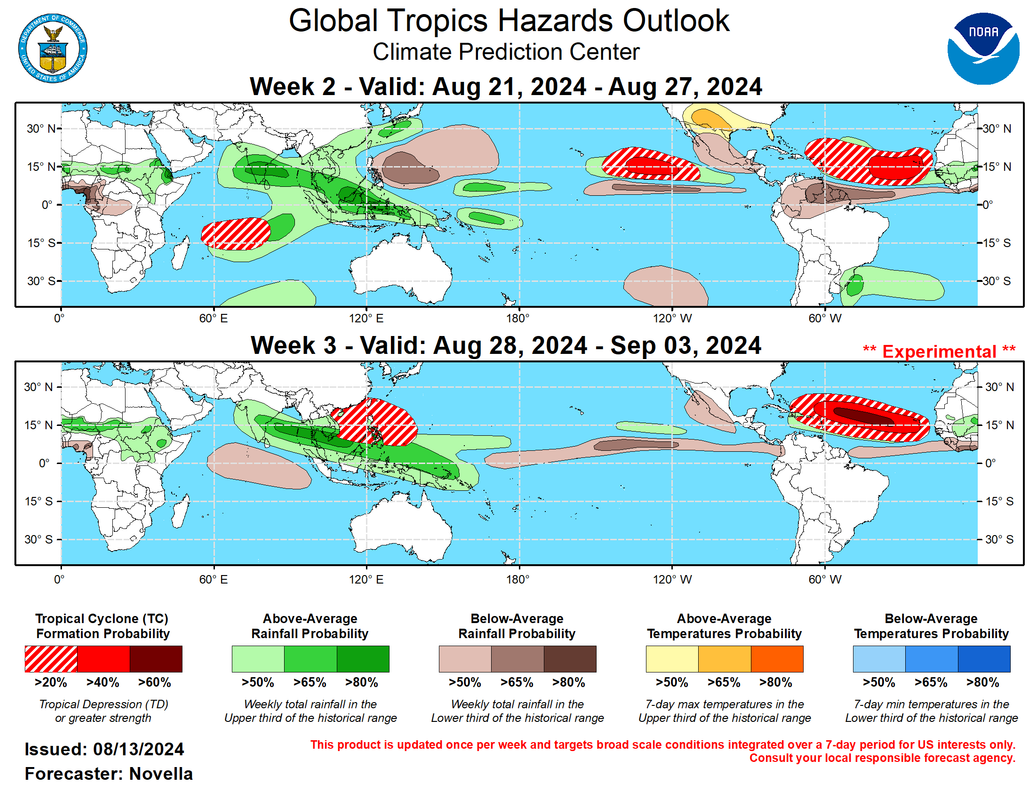
For the tropical Atlantic, both the ensembles and probabilistic tools have been surprisingly muted in regards to TC potential in spite of an eastward propagating MJO over the Indian Ocean. The overall lack of support in the guidance, particularly during week-2, invariably lowers forecast confidence in the Main Development Region (MDR). Notwithstanding, it is recognized that some of these tools have been slow to converge on TC potential associated with TCs Debby and Ernesto since late July, and it is hard to ignore the reemergence of intraseasonal activity that would highly favor TC genesis in the MDR. As a result, 40% chances are posted in the eastern MDR given climatology and MJO composites, with a broader area of 20% chances extending into the Caribbean. Due to better support in the probabilistic TC tools during week-3, with more easterly waves favored to exit West Africa towards the end of the month, 60% chances are issued from 35W to 55W where negative shear anomalies are favored to be strongest heading into September. https://www.cpc.ncep.noaa.gov/products/ ... /index.php
8 likes
-
weeniepatrol

- Category 5
- Posts: 1340
- Joined: Sat Aug 22, 2020 5:30 pm
- Location: WA State
Re: 2024 Indicators: SST's, MSLP, Shear, SAL, Steering, Instability (Day 16+ Climate Models)
SFLcane wrote:For the tropical Atlantic, both the ensembles and probabilistic tools have been surprisingly muted in regards to TC potential in spite of an eastward propagating MJO over the Indian Ocean. The overall lack of support in the guidance, particularly during week-2, invariably lowers forecast confidence in the Main Development Region (MDR). Notwithstanding, it is recognized that some of these tools have been slow to converge on TC potential associated with TCs Debby and Ernesto since late July, and it is hard to ignore the reemergence of intraseasonal activity that would highly favor TC genesis in the MDR. As a result, 40% chances are posted in the eastern MDR given climatology and MJO composites, with a broader area of 20% chances extending into the Caribbean. Due to better support in the probabilistic TC tools during week-3, with more easterly waves favored to exit West Africa towards the end of the month, 60% chances are issued from 35W to 55W where negative shear anomalies are favored to be strongest heading into September. https://www.cpc.ncep.noaa.gov/products/ ... /index.php
https://i.postimg.cc/WbbpHDQb/mmmm.png
Excellent post. This is my personal thoughts too. There WILL be hurricanes whether guidance shows it or not. If nothing else, delayed development until the magical 50W longitude line
5 likes

Re: 2024 Indicators: SST's, MSLP, Shear, SAL, Steering, Instability (Day 16+ Climate Models)
SFLcane wrote:For the tropical Atlantic, both the ensembles and probabilistic tools have been surprisingly muted in regards to TC potential in spite of an eastward propagating MJO over the Indian Ocean. The overall lack of support in the guidance, particularly during week-2, invariably lowers forecast confidence in the Main Development Region (MDR). Notwithstanding, it is recognized that some of these tools have been slow to converge on TC potential associated with TCs Debby and Ernesto since late July, and it is hard to ignore the reemergence of intraseasonal activity that would highly favor TC genesis in the MDR. As a result, 40% chances are posted in the eastern MDR given climatology and MJO composites, with a broader area of 20% chances extending into the Caribbean. Due to better support in the probabilistic TC tools during week-3, with more easterly waves favored to exit West Africa towards the end of the month, 60% chances are issued from 35W to 55W where negative shear anomalies are favored to be strongest heading into September. https://www.cpc.ncep.noaa.gov/products/ ... /index.php
https://i.postimg.cc/WbbpHDQb/mmmm.png
That looks pretty far north. Don’t see anything getting into the Gulf with the way that looks.
0 likes
-
SFLcane
- S2K Supporter
- Posts: 10281
- Age: 48
- Joined: Sat Jun 05, 2010 1:44 pm
- Location: Lake Worth Florida
Re: 2024 Indicators: SST's, MSLP, Shear, SAL, Steering, Instability (Day 16+ Climate Models)
Cpv17 wrote:SFLcane wrote:For the tropical Atlantic, both the ensembles and probabilistic tools have been surprisingly muted in regards to TC potential in spite of an eastward propagating MJO over the Indian Ocean. The overall lack of support in the guidance, particularly during week-2, invariably lowers forecast confidence in the Main Development Region (MDR). Notwithstanding, it is recognized that some of these tools have been slow to converge on TC potential associated with TCs Debby and Ernesto since late July, and it is hard to ignore the reemergence of intraseasonal activity that would highly favor TC genesis in the MDR. As a result, 40% chances are posted in the eastern MDR given climatology and MJO composites, with a broader area of 20% chances extending into the Caribbean. Due to better support in the probabilistic TC tools during week-3, with more easterly waves favored to exit West Africa towards the end of the month, 60% chances are issued from 35W to 55W where negative shear anomalies are favored to be strongest heading into September. https://www.cpc.ncep.noaa.gov/products/ ... /index.php
https://i.postimg.cc/WbbpHDQb/mmmm.png
That looks pretty far north. Don’t see anything getting into the Gulf with the way that looks.
Those color hatched areas are not tc tracks by any means they just show development potential similar to the ones the NHC uses which is misinterpreted 24/7.
3 likes
Re: 2024 Indicators: SST's, MSLP, Shear, SAL, Steering, Instability (Day 16+ Climate Models)
SFLcane wrote:Cpv17 wrote:SFLcane wrote:For the tropical Atlantic, both the ensembles and probabilistic tools have been surprisingly muted in regards to TC potential in spite of an eastward propagating MJO over the Indian Ocean. The overall lack of support in the guidance, particularly during week-2, invariably lowers forecast confidence in the Main Development Region (MDR). Notwithstanding, it is recognized that some of these tools have been slow to converge on TC potential associated with TCs Debby and Ernesto since late July, and it is hard to ignore the reemergence of intraseasonal activity that would highly favor TC genesis in the MDR. As a result, 40% chances are posted in the eastern MDR given climatology and MJO composites, with a broader area of 20% chances extending into the Caribbean. Due to better support in the probabilistic TC tools during week-3, with more easterly waves favored to exit West Africa towards the end of the month, 60% chances are issued from 35W to 55W where negative shear anomalies are favored to be strongest heading into September. https://www.cpc.ncep.noaa.gov/products/ ... /index.php
https://i.postimg.cc/WbbpHDQb/mmmm.png
That looks pretty far north. Don’t see anything getting into the Gulf with the way that looks.
Those color hatched areas are not tc tracks by any means they just show development potential similar to the ones the NHC uses which is misinterpreted 24/7.
Oh yeah, I know, but if something develops in those areas it would probably be a recurve or only a threat to the northern islands, Bermuda, or the EC.
0 likes
Re: 2024 Indicators: SST's, MSLP, Shear, SAL, Steering, Instability (Day 16+ Climate Models)
Now the NHC forecasts Ernesto to become a major on August 16. Key point: That's before the August 20 bell-ringing date.
Amid the Ernesto forecasts followed by the relative quiet period that's currently depicted by the models, it's easy to think Ernesto was supposed to be the first TC outbreak which underperformed. But during recent seasons, the period leading up to August 20 -- sometimes even a few days after -- were often even quieter: without model enthusiasm like right now, but also without a mid-August major, and certainly without a July Cat 5 before that. The bell-ringing period is often known for sudden upticks in both model forecasts and actual activity (that's often poorly forecast by the models beforehand), and the presence of Ernesto shouldn't trick us into thinking that it was the entire uptick.
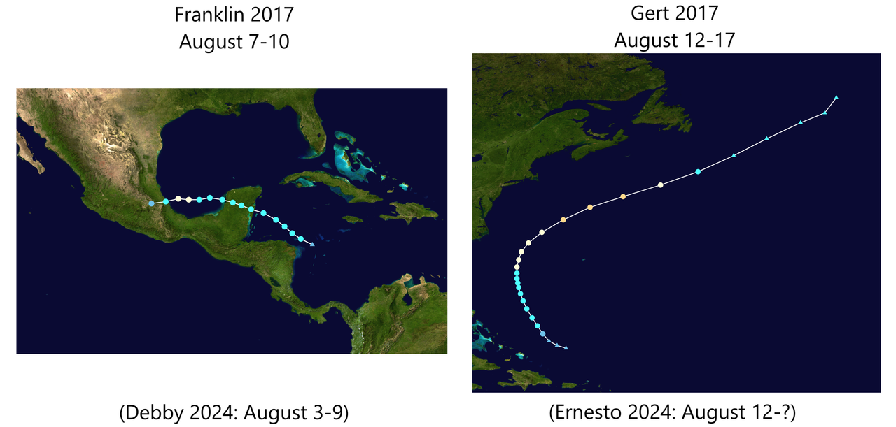
In fact, the most comparable situation to August 2024 so far is actually August 2017. Franklin made landfall on the "Gulf coast" as a Cat 1 just like Debby, and Gert was a recurving Cat 2 in the subtropics, which didn't even form within the MDR like Ernesto did. Even their time periods match 2024 almost exactly.
Now recall what 2017 did afterwards? Harvey Part I did form in the MDR on August 17, but became a "failed" 40 kt tropical storm that succumbed to shear just 2 days later, and wouldn't have regenerated in the Gulf until August 23. PTC 10 tracked across the Atlantic behind Harvey and "recurved" without development, becoming the first failed PTC in the process. The actual insane MDR activity, which 2017 was well-known for, didn't start until Irma formed on August 30 (16 days from today's date).
During the years that followed...
Early August 2017 was obviously not what that season was known for, but it was already the most active one since at least 2013. And 2024 is on track to surpass that as per NHC's forecast.
While it's technically not impossible that Ernesto will be the entire "late August outbreak", there's at least a legitimate chance, if not a higher chance, that 2024 is a thought experiment of: "What if we repeat 2017 YTD, but replace its first 5 record-low-ACE TS with 2 TS and a Cat 5?"
Amid the Ernesto forecasts followed by the relative quiet period that's currently depicted by the models, it's easy to think Ernesto was supposed to be the first TC outbreak which underperformed. But during recent seasons, the period leading up to August 20 -- sometimes even a few days after -- were often even quieter: without model enthusiasm like right now, but also without a mid-August major, and certainly without a July Cat 5 before that. The bell-ringing period is often known for sudden upticks in both model forecasts and actual activity (that's often poorly forecast by the models beforehand), and the presence of Ernesto shouldn't trick us into thinking that it was the entire uptick.
In fact, the most comparable situation to August 2024 so far is actually August 2017. Franklin made landfall on the "Gulf coast" as a Cat 1 just like Debby, and Gert was a recurving Cat 2 in the subtropics, which didn't even form within the MDR like Ernesto did. Even their time periods match 2024 almost exactly.
Now recall what 2017 did afterwards? Harvey Part I did form in the MDR on August 17, but became a "failed" 40 kt tropical storm that succumbed to shear just 2 days later, and wouldn't have regenerated in the Gulf until August 23. PTC 10 tracked across the Atlantic behind Harvey and "recurved" without development, becoming the first failed PTC in the process. The actual insane MDR activity, which 2017 was well-known for, didn't start until Irma formed on August 30 (16 days from today's date).
During the years that followed...
- Florence 2018 only formed on August 31.
- 2019 had nothing on the models until Chantal rang the bell precisely on August 20. Dorian formed on August 24, and IIRC only started appearing on models during the couple days inbetween.
- 2020 had high quantity even during early season, but its YTD profile was still rather thin with two landfalling Cat 1s (despite 11 storms total). Laura only formed on August 20 and became a hurricane on August 25.
- Grace 2021 RI'ed to a major on August 20 to ring the bell again, but before then, it and Fred were seen as underwhelming "Caribbean kayaks" that weakened or dissipated through the Greater Antilles. The main highlight of the season, Ida, took another 6 days to form.
- 2022 was infamous for a storm-free August, but even then, it still had 2 hurricanes in early September, followed by Fiona and Ian to many people's surprise.
- The trio of Emily, Franklin and Gert 2023 formed right on August 20 (yet again), but while they were hinted at on the models before, nobody could have said with confidence about 3 storms until that day. That August was also completely quiet before that.
Early August 2017 was obviously not what that season was known for, but it was already the most active one since at least 2013. And 2024 is on track to surpass that as per NHC's forecast.
While it's technically not impossible that Ernesto will be the entire "late August outbreak", there's at least a legitimate chance, if not a higher chance, that 2024 is a thought experiment of: "What if we repeat 2017 YTD, but replace its first 5 record-low-ACE TS with 2 TS and a Cat 5?"
14 likes
TC naming lists: retirements and intensity
Most aggressive Advisory #1's in North Atlantic (cr. kevin for starting the list)
Most aggressive Advisory #1's in North Atlantic (cr. kevin for starting the list)
-
CFLHurricane

- Category 1

- Posts: 349
- Joined: Thu Mar 27, 2014 5:56 pm
- Location: Floriduh
Re: 2024 Indicators: SST's, MSLP, Shear, SAL, Steering, Instability (Day 16+ Climate Models)
I noticed the large wave over Mali kicking storms north over the Sahara. Does anyone think this may bring an end to the Saharan dust over the next week? It is that switch flipping time of year with the bell of peak season ringing in six days.
3 likes
I'm not a meteorologist, but I did stay at a motel 8.
-
weeniepatrol
- Category 5
- Posts: 1340
- Joined: Sat Aug 22, 2020 5:30 pm
- Location: WA State
Re: 2024 Indicators: SST's, MSLP, Shear, SAL, Steering, Instability (Day 16+ Climate Models)
You know the African monsoon is peaking when 55 kt easterlies south of Cabo Verde

5 likes
-
Category5Kaiju

- Category 5
- Posts: 4330
- Joined: Thu Dec 24, 2020 12:45 pm
- Location: Seattle and Phoenix
Re: 2024 Indicators: SST's, MSLP, Shear, SAL, Steering, Instability (Day 16+ Climate Models)
Teban54 wrote:Now the NHC forecasts Ernesto to become a major on August 16. Key point: That's before the August 20 bell-ringing date.
Amid the Ernesto forecasts followed by the relative quiet period that's currently depicted by the models, it's easy to think Ernesto was supposed to be the first TC outbreak which underperformed. But during recent seasons, the period leading up to August 20 -- sometimes even a few days after -- were often even quieter: without model enthusiasm like right now, but also without a mid-August major, and certainly without a July Cat 5 before that. The bell-ringing period is often known for sudden upticks in both model forecasts and actual activity (that's often poorly forecast by the models beforehand), and the presence of Ernesto shouldn't trick us into thinking that it was the entire uptick.
In fact, the most comparable situation to August 2024 so far is actually August 2017. Franklin made landfall on the "Gulf coast" as a Cat 1 just like Debby, and Gert was a recurving Cat 2 in the subtropics, which didn't even form within the MDR like Ernesto did. Even their time periods match 2024 almost exactly.
https://i.postimg.cc/2jL1X1nQ/image.png
Now recall what 2017 did afterwards? Harvey Part I did form in the MDR on August 17, but became a "failed" 40 kt tropical storm that succumbed to shear just 2 days later, and wouldn't have regenerated in the Gulf until August 23. PTC 10 tracked across the Atlantic behind Harvey and "recurved" without development, becoming the first failed PTC in the process. The actual insane MDR activity, which 2017 was well-known for, didn't start until Irma formed on August 30 (16 days from today's date).
During the years that followed...
- Florence 2018 only formed on August 31.
- 2019 had nothing on the models until Chantal rang the bell precisely on August 20. Dorian formed on August 24, and IIRC only started appearing on models during the couple days inbetween.
- 2020 had high quantity even during early season, but its YTD profile was still rather thin with two landfalling Cat 1s (despite 11 storms total). Laura only formed on August 20 and became a hurricane on August 25.
- Grace 2021 RI'ed to a major on August 20 to ring the bell again, but before then, it and Fred were seen as underwhelming "Caribbean kayaks" that weakened or dissipated through the Greater Antilles. The main highlight of the season, Ida, took another 6 days to form.
- 2022 was infamous for a storm-free August, but even then, it still had 2 hurricanes in early September, followed by Fiona and Ian to many people's surprise.
- The trio of Emily, Franklin and Gert 2023 formed right on August 20 (yet again), but while they were hinted at on the models before, nobody could have said with confidence about 3 storms until that day. That August was also completely quiet before that.
Early August 2017 was obviously not what that season was known for, but it was already the most active one since at least 2013. And 2024 is on track to surpass that as per NHC's forecast.
While it's technically not impossible that Ernesto will be the entire "late August outbreak", there's at least a legitimate chance, if not a higher chance, that 2024 is a thought experiment of: "What if we repeat 2017 YTD, but replace its first 5 record-low-ACE TS with 2 TS and a Cat 5?"
It's the same clock. And it'll be the case when we get a season with a June and a July Category 5 hurricane, I can tell you that
1 likes
Unless explicitly stated, all info in my posts is based on my own opinions and observations. Tropical storms and hurricanes can be extremely dangerous. Refer to an accredited weather research agency or meteorologist if you need to make serious decisions regarding an approaching storm.
-
WaveBreaking

- Category 2

- Posts: 717
- Joined: Sun Jun 30, 2024 11:33 am
- Location: US
Re: 2024 Indicators: SST's, MSLP, Shear, SAL, Steering, Instability (Day 16+ Climate Models)
CFLHurricane wrote:I noticed the large wave over Mali kicking storms north over the Sahara. Does anyone think this may bring an end to the Saharan dust over the next week? It is that switch flipping time of year with the bell of peak season ringing in six days.
Yeah that wave (and the whole monsoon in general) is really pronounced on visible. It almost has a closed circulation too

3 likes
I am NOT a professional meteorologist, so take all of my posts with a grain of salt. My opinions are mine and mine alone.
Re: 2024 Indicators: SST's, MSLP, Shear, SAL, Steering, Instability (Day 16+ Climate Models)
https://x.com/philklotzbach/status/1823742274528006241
https://x.com/WxTca/status/1823493478892122501
https://x.com/WxTca/status/1823493492515201441
https://x.com/WxTca/status/1823493478892122501
https://x.com/WxTca/status/1823493492515201441
0 likes
TC naming lists: retirements and intensity
Most aggressive Advisory #1's in North Atlantic (cr. kevin for starting the list)
Most aggressive Advisory #1's in North Atlantic (cr. kevin for starting the list)
-
toad strangler

- S2K Supporter
- Posts: 4546
- Joined: Sun Jul 28, 2013 3:09 pm
- Location: Earth
- Contact:
Re: 2024 Indicators: SST's, MSLP, Shear, SAL, Steering, Instability (Day 16+ Climate Models)
This one I don't get at all. Quiet? Uhhh lol. Open your eyes Deelan and there is a hurricane in the basin. Poised to become a major very possibly. Oy vey

4 likes
My Weather Station
https://www.wunderground.com/dashboard/pws/KFLPORTS603
https://www.wunderground.com/dashboard/pws/KFLPORTS603
-
AnnularCane

- S2K Supporter
- Posts: 2957
- Joined: Thu Jun 08, 2006 9:18 am
- Location: Wytheville, VA
Re: 2024 Indicators: SST's, MSLP, Shear, SAL, Steering, Instability (Day 16+ Climate Models)
toad strangler wrote:
This one I don't get at all. Quiet? Uhhh lol. Open your eyes Deelan and there is a hurricane in the basin. Poised to become a major very possibly. Oy vey
Two hurricanes so far, one possible major, both affecting various landmasses, and August isn't even half over yet.
Last edited by AnnularCane on Wed Aug 14, 2024 11:21 am, edited 1 time in total.
3 likes
"But it never rained rain. It never snowed snow. And it never blew just wind. It rained things like soup and juice. It snowed mashed potatoes and green peas. And sometimes the wind blew in storms of hamburgers." -- Judi Barrett, Cloudy with a Chance of Meatballs
-
WeatherBoy2000
- Category 1
- Posts: 460
- Joined: Mon Apr 10, 2023 9:29 am
Re: 2024 Indicators: SST's, MSLP, Shear, SAL, Steering, Instability (Day 16+ Climate Models)
https://x.com/philklotzbach/status/1823742274528006241
Despite the quantity of storms, we seem to be well on track to achieve the hurricane numbers predicted. The two seasons listed from the current +amo era (1995/2005) were both 200+ ace seasons with at least 11 hurricanes.
Despite the quantity of storms, we seem to be well on track to achieve the hurricane numbers predicted. The two seasons listed from the current +amo era (1995/2005) were both 200+ ace seasons with at least 11 hurricanes.
5 likes

Re: 2024 Indicators: SST's, MSLP, Shear, SAL, Steering, Instability (Day 16+ Climate Models)
Cpv17 wrote:SFLcane wrote:Cpv17 wrote:
That looks pretty far north. Don’t see anything getting into the Gulf with the way that looks.
Those color hatched areas are not tc tracks by any means they just show development potential similar to the ones the NHC uses which is misinterpreted 24/7.
Oh yeah, I know, but if something develops in those areas it would probably be a recurve or only a threat to the northern islands, Bermuda, or the EC.
You're right, "IF". I imagine your if will occur with one or two of the remaining large monsoonal lows that'll come off the continent at the further north latitudes as Webb has pointed out. Beyond that though, SFLcane is simply pointing out the intraseasonal factors which work hand-in-hand with climatology. I personally given less credence to climo, and even less to a negative MJO pattern over the next couple of months. Debby and Ernesto were large envelope systems, but I think that what we are apt to begin to see are more like the tropical wave that is trailing Ernesto. Small vorticities off the southern axis of tropical waves further west in the MDR that will suddenly flare up and upon increasingly moist conditions and with less volatile easterly shear will be fairly quick to develop. Smaller, quicker to develop, with rapid strengthening becoming the new norm. I see the MJO simply as an effect to further enhance activity but less of an adverse impact where favorable conditions otherwise exist.
0 likes
Andy D
(For official information, please refer to the NHC and NWS products.)
(For official information, please refer to the NHC and NWS products.)
Re: 2024 Indicators: SST's, MSLP, Shear, SAL, Steering, Instability (Day 16+ Climate Models)
Teban54 wrote:The bell-ringing period is often known for sudden upticks in both model forecasts and actual activity (that's often poorly forecast by the models beforehand)
And not even a full day later, the EPS lit up... Bingo!
6 likes
TC naming lists: retirements and intensity
Most aggressive Advisory #1's in North Atlantic (cr. kevin for starting the list)
Most aggressive Advisory #1's in North Atlantic (cr. kevin for starting the list)
Who is online
Users browsing this forum: No registered users and 68 guests