Early June Development in WCarib or BOC? (Is Invest 91L)
Moderator: S2k Moderators
Forum rules

The posts in this forum are NOT official forecasts and should not be used as such. They are just the opinion of the poster and may or may not be backed by sound meteorological data. They are NOT endorsed by any professional institution or STORM2K. For official information, please refer to products from the National Hurricane Center and National Weather Service.
-
TheStormExpert

-
wxman57

- Moderator-Pro Met

- Posts: 23174
- Age: 68
- Joined: Sat Jun 21, 2003 8:06 pm
- Location: Houston, TX (southwest)
Re: Early June Development in Western Caribbean or BOC?
Hurricaneman wrote:Is it possible if it makes it to the BOC without discontinuation of advisories that this may still be Barbara if it reorganizes and hits somewhere in the Gulf making Andrea not be used until a later system
Highly unlikely it could survive to reach the BoC with its surface circulation intact. But as was stated, if it DID happen then it would be renamed TD One in the BoC.
0 likes
-
Hurricaneman

- Category 5

- Posts: 7404
- Age: 45
- Joined: Tue Aug 31, 2004 3:24 pm
- Location: central florida
Re: Early June Development in Western Caribbean or BOC?
If one looks at the 0zGFS the low starts to form around 90hrs, but the broad low covers the BOC and the yucatan which starts to consolidate round 150hrs in the BOC
0 likes


Re: Early June Development in Western Caribbean or BOC?
Convection is really firing this morning:

0 likes
-
Hurricaneman
- Category 5
- Posts: 7404
- Age: 45
- Joined: Tue Aug 31, 2004 3:24 pm
- Location: central florida
Re: Early June Development in Western Caribbean or BOC?
Im starting to wonder if this could become both Andrea and ?Barry?, the GFS has development at times of lows at times in the BOC and near Belieze or I could just be over analyzing
0 likes
-
Hurricaneman
- Category 5
- Posts: 7404
- Age: 45
- Joined: Tue Aug 31, 2004 3:24 pm
- Location: central florida
Re: Early June Development in Western Caribbean or BOC?
I just looked at the 6zGFS and it seems to be moving to the Euros depiction of this system so if I was a betting man I would go with the euros depiction
0 likes
-
Jay Grymes
- Tropical Wave

- Posts: 2
- Joined: Fri Aug 17, 2007 1:18 pm
OKay .. I'm confused. From the HRD/AOML TCFAQ, B5:
The rule used to be that if the tropical storm or hurricane moved into a different basin . . .
However, these rules have now changed at the National Hurricane Center and if the system remains a tropical cyclone as it moves across Central America, then it will keep the original name. Only if the tropical cyclone dissipates with just a tropical disturbance remaining, will the hurricane warning center give the system a new name assuming it becomes a tropical cyclone once again in its new basin.
0 likes
-
Hurricaneman
- Category 5
- Posts: 7404
- Age: 45
- Joined: Tue Aug 31, 2004 3:24 pm
- Location: central florida
Re: Early June Development in Western Caribbean or BOC?
The 12zGFS is starting development at 102hrs in the GOM 100mi NW of the Yucatan, thats a change that needs to be monitored
0 likes
-
Dean4Storms
- S2K Supporter

- Posts: 6358
- Age: 63
- Joined: Sun Aug 31, 2003 1:01 pm
- Location: Miramar Bch. FL
Re:
Jay Grymes wrote:OKay .. I'm confused. From the HRD/AOML TCFAQ, B5:
The rule used to be that if the tropical storm or hurricane moved into a different basin . . .
However, these rules have now changed at the National Hurricane Center and if the system remains a tropical cyclone as it moves across Central America, then it will keep the original name. Only if the tropical cyclone dissipates with just a tropical disturbance remaining, will the hurricane warning center give the system a new name assuming it becomes a tropical cyclone once again in its new basin.
That is my understanding now.
If Tropical Storm Barbara remains a Closed Low (TD) over into the BOC and attains TS Status once again it remains named Barbara.
0 likes
-
Aric Dunn
- Category 5
- Posts: 21238
- Age: 43
- Joined: Sun Sep 19, 2004 9:58 pm
- Location: Ready for the Chase.
- Contact:
Re: Early June Development in Western Caribbean or BOC?
Hurricaneman wrote:The 12zGFS is starting development at 102hrs in the GOM 100mi NW of the Yucatan, thats a change that needs to be monitored
actually in a as little as 72 hours. likely the remnants of Barbara reforming
0 likes
Note: If I make a post that is brief. Please refer back to previous posts for the analysis or reasoning. I do not re-write/qoute what my initial post said each time.
If there is nothing before... then just ask
Space & Atmospheric Physicist, Embry-Riddle Aeronautical University,
I believe the sky is falling...
If there is nothing before... then just ask
Space & Atmospheric Physicist, Embry-Riddle Aeronautical University,
I believe the sky is falling...
-
Riptide

- Category 2

- Posts: 753
- Age: 34
- Joined: Fri Jul 23, 2010 3:33 pm
- Location: Cape May, New Jersey
- Contact:
Re: Re:
Dean4Storms wrote:Jay Grymes wrote:OKay .. I'm confused. From the HRD/AOML TCFAQ, B5:
The rule used to be that if the tropical storm or hurricane moved into a different basin . . .
However, these rules have now changed at the National Hurricane Center and if the system remains a tropical cyclone as it moves across Central America, then it will keep the original name. Only if the tropical cyclone dissipates with just a tropical disturbance remaining, will the hurricane warning center give the system a new name assuming it becomes a tropical cyclone once again in its new basin.
That is my understanding now.
If Tropical Storm Barbara remains a Closed Low (TD) over into the BOC and attains TS Status once again it remains named Barbara.
Yeah but does the ACE count towards the Atlantic Basin and such?
0 likes
-
Dean4Storms
- S2K Supporter
- Posts: 6358
- Age: 63
- Joined: Sun Aug 31, 2003 1:01 pm
- Location: Miramar Bch. FL
Re: Re:
Riptide wrote:Dean4Storms wrote:Jay Grymes wrote:OKay .. I'm confused. From the HRD/AOML TCFAQ, B5:
The rule used to be that if the tropical storm or hurricane moved into a different basin . . .
However, these rules have now changed at the National Hurricane Center and if the system remains a tropical cyclone as it moves across Central America, then it will keep the original name. Only if the tropical cyclone dissipates with just a tropical disturbance remaining, will the hurricane warning center give the system a new name assuming it becomes a tropical cyclone once again in its new basin.
That is my understanding now.
If Tropical Storm Barbara remains a Closed Low (TD) over into the BOC and attains TS Status once again it remains named Barbara.
Yeah but does the ACE count towards the Atlantic Basin and such?
I'm not sure how they handle the ACE with this. Someone else here might know.
0 likes
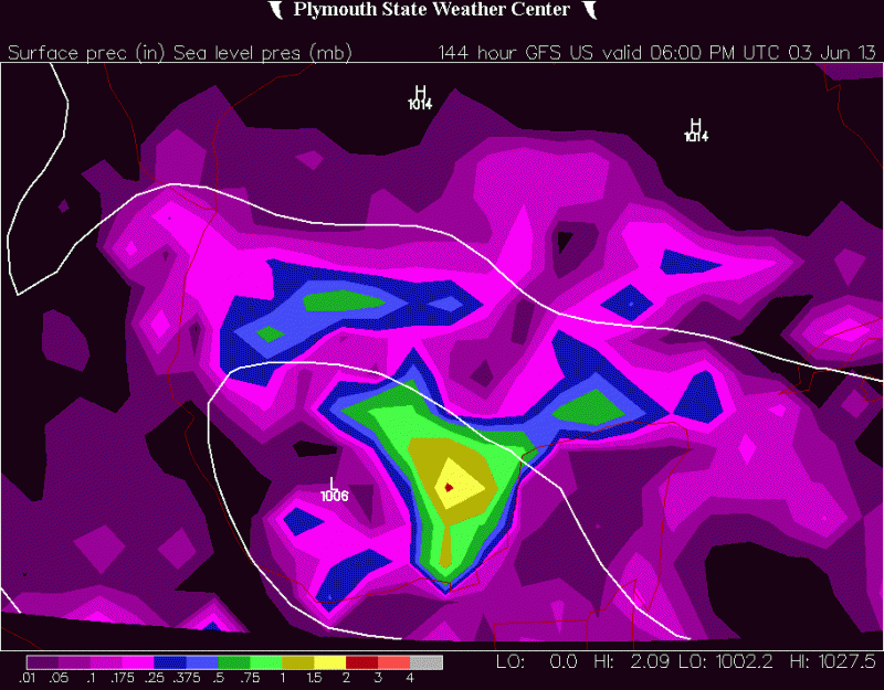
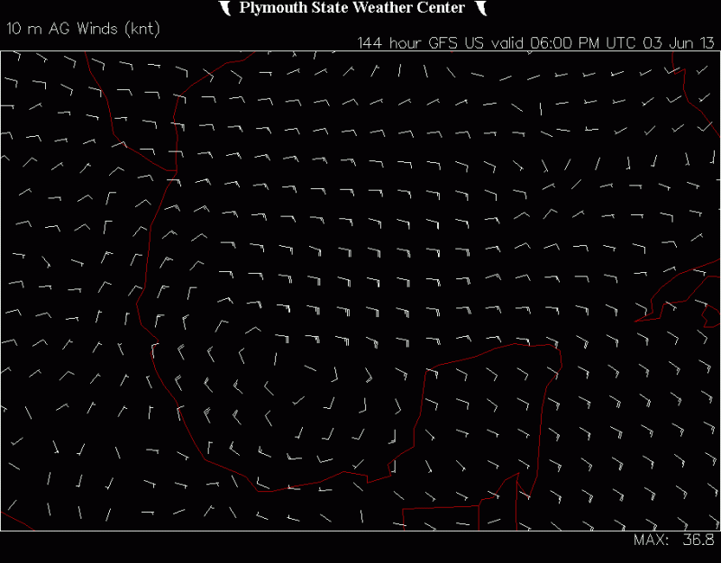
Re: Early June Development in Western Caribbean or BOC?
Aric Dunn wrote:Hurricaneman wrote:The 12zGFS is starting development at 102hrs in the GOM 100mi NW of the Yucatan, thats a change that needs to be monitored
actually in a as little as 72 hours. likely the remnants of Barbara reforming
12Z GFS at 72hr:

0 likes
-
Hurricaneman
- Category 5
- Posts: 7404
- Age: 45
- Joined: Tue Aug 31, 2004 3:24 pm
- Location: central florida
Re: Early June Development in Western Caribbean or BOC?
I believe the ACE goes to the basin it is in so if it crosses into the BOC the atlantic gets the ACE numbers, but I could be wrong
0 likes
-
Aric Dunn
- Category 5
- Posts: 21238
- Age: 43
- Joined: Sun Sep 19, 2004 9:58 pm
- Location: Ready for the Chase.
- Contact:
Re: Early June Development in Western Caribbean or BOC?
N2FSU wrote:Aric Dunn wrote:Hurricaneman wrote:The 12zGFS is starting development at 102hrs in the GOM 100mi NW of the Yucatan, thats a change that needs to be monitored
actually in a as little as 72 hours. likely the remnants of Barbara reforming
12Z GFS at 72hr:
12x 72 hr

0 likes
Note: If I make a post that is brief. Please refer back to previous posts for the analysis or reasoning. I do not re-write/qoute what my initial post said each time.
If there is nothing before... then just ask
Space & Atmospheric Physicist, Embry-Riddle Aeronautical University,
I believe the sky is falling...
If there is nothing before... then just ask
Space & Atmospheric Physicist, Embry-Riddle Aeronautical University,
I believe the sky is falling...
-
Dean4Storms
- S2K Supporter
- Posts: 6358
- Age: 63
- Joined: Sun Aug 31, 2003 1:01 pm
- Location: Miramar Bch. FL
-
Dean4Storms
- S2K Supporter
- Posts: 6358
- Age: 63
- Joined: Sun Aug 31, 2003 1:01 pm
- Location: Miramar Bch. FL
-
Dean4Storms
- S2K Supporter
- Posts: 6358
- Age: 63
- Joined: Sun Aug 31, 2003 1:01 pm
- Location: Miramar Bch. FL
Who is online
Users browsing this forum: No registered users and 314 guests