Western Caribbean Area of Interest: (Is INVEST 90L)
Moderator: S2k Moderators
Forum rules

The posts in this forum are NOT official forecasts and should not be used as such. They are just the opinion of the poster and may or may not be backed by sound meteorological data. They are NOT endorsed by any professional institution or STORM2K. For official information, please refer to products from the National Hurricane Center and National Weather Service.
-
gatorcane

- S2K Supporter

- Posts: 23708
- Age: 48
- Joined: Sun Mar 13, 2005 3:54 pm
- Location: Boca Raton, FL
Re: Western Caribbean Area of Interest
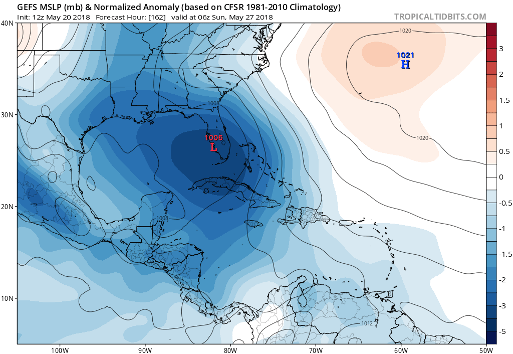
The 12Z GFS ensemble mean continues to suggest Florida peninsula. They couldn’t be more different than the ECMWF and its ensemble mean. Regardless of development, watching the Euro vs GFS on this is fun to watch:
0 likes
-
stormlover2013
-
northjaxpro

- S2K Supporter
- Posts: 8900
- Joined: Mon Sep 27, 2010 11:21 am
- Location: Jacksonville, FL
Re: Western Caribbean Area of Interest
This is the first run from GFS in quite some time which at least shows the potential center being in the extreme SE GOM, as opposed to it being east of Florida in its runs the past couple of days. It is not much of a shift west (left), but a very subtle one nonetheless.
We will see if this 12Z GFS run starts a trend of it finally caving to the EURO solution of traversing the potential cyclone in the GOM.
0 likes
NEVER, EVER SAY NEVER in the tropics and weather in general, and most importantly, with life itself!!
________________________________________________________________________________________
Fay 2008 Beryl 2012 Debby 2012 Colin 2016 Hermine 2016 Julia 2016 Matthew 2016 Irma 2017 Dorian 2019
________________________________________________________________________________________
Fay 2008 Beryl 2012 Debby 2012 Colin 2016 Hermine 2016 Julia 2016 Matthew 2016 Irma 2017 Dorian 2019
-
cycloneye

- Admin

- Posts: 149372
- Age: 69
- Joined: Thu Oct 10, 2002 10:54 am
- Location: San Juan, Puerto Rico
Re: Western Caribbean Area of Interest
First mention of a low.

0 likes
Visit the Caribbean-Central America Weather Thread where you can find at first post web cams,radars
and observations from Caribbean basin members Click Here
and observations from Caribbean basin members Click Here
-
gatorcane
- S2K Supporter
- Posts: 23708
- Age: 48
- Joined: Sun Mar 13, 2005 3:54 pm
- Location: Boca Raton, FL
Re: Western Caribbean Area of Interest
12Z EC has this near LA coast at 144 hours so has sped things up and not budging on NE track into FL peninsula the GFS insists on.
0 likes

Re: Western Caribbean Area of Interest
AJC3 wrote:wxman57 wrote:One thing I've noticed over the years is that the EC does poorly in a high-shear environment. It tends to move the disturbance/storm with the lower-level flow. Think Debby of 2012 in the central Gulf. EC predicted hurricane into Texas, while the GFS predicted sheared weak TS into the FL Peninsula. Strong SW-WSW shear drove all convection ENE into Florida, along with a weak center. Look at the shear forecast for later this week (below). 40-50 kts of shear coming from the WSW-SW. EC ensembles are north to western FL Panhandle, while the GFS ensembles all take it to southern Florida. I'd go with the GFS here.
Exactly. Another great local example of this occurring is the October 9, 2011 "no name storm". I got burned siding with the EC (surface low beneath the H50 low in the SE GOMEX) over the GFS (surface low forming off the Florida east coast, which was your call) in that case. We both know what happened there - 93L.
I learned something about the EC's bias that day, which is why I made my post early yesterday evening.
So yall are probably correct but this is what 4 straight runs of the Euro into the Northern gulf coast.

0 likes
The following post is NOT an official forecast and should not be used as such. It is just the opinion of the poster and may or may not be backed by sound meteorological data. It is NOT endorsed by any professional institution including storm2k.org For Official Information please refer to the NHC and NWS products.
-
cycloneye
- Admin
- Posts: 149372
- Age: 69
- Joined: Thu Oct 10, 2002 10:54 am
- Location: San Juan, Puerto Rico
Re: Western Caribbean Area of Interest
Is in the same place at 192 hours?
1 likes
Visit the Caribbean-Central America Weather Thread where you can find at first post web cams,radars
and observations from Caribbean basin members Click Here
and observations from Caribbean basin members Click Here
-
Dean4Storms
- S2K Supporter
- Posts: 6358
- Age: 63
- Joined: Sun Aug 31, 2003 1:01 pm
- Location: Miramar Bch. FL
Re: Western Caribbean Area of Interest
12z ECM into LA just SW of New Orleans at 156hr at 998mb..... Showing some wind gusts well out east of center to just over 50mph. This would either be a Sub or purely Tropical Storm but maybe sustained winds around 40mph.
0 likes
-
cycloneye
- Admin
- Posts: 149372
- Age: 69
- Joined: Thu Oct 10, 2002 10:54 am
- Location: San Juan, Puerto Rico
Re: Western Caribbean Area of Interest
cycloneye wrote:Is in the same place at 192 hours?
In fact retograding to the SW off coast at 216 hours.

0 likes
Visit the Caribbean-Central America Weather Thread where you can find at first post web cams,radars
and observations from Caribbean basin members Click Here
and observations from Caribbean basin members Click Here
-
Dean4Storms
- S2K Supporter
- Posts: 6358
- Age: 63
- Joined: Sun Aug 31, 2003 1:01 pm
- Location: Miramar Bch. FL
Re: Western Caribbean Area of Interest
Yep, out to 192 hours still just WSW of New Orleans and at 999mb. The deluge is on for NO!
0 likes
-
Dean4Storms
- S2K Supporter
- Posts: 6358
- Age: 63
- Joined: Sun Aug 31, 2003 1:01 pm
- Location: Miramar Bch. FL
Re: Western Caribbean Area of Interest
At 210 hrs nearly 16-18 inches of rain in the NO area
0 likes
-
cycloneye
- Admin
- Posts: 149372
- Age: 69
- Joined: Thu Oct 10, 2002 10:54 am
- Location: San Juan, Puerto Rico
Re: Western Caribbean Area of Interest
At 240 hours.

1 likes
Visit the Caribbean-Central America Weather Thread where you can find at first post web cams,radars
and observations from Caribbean basin members Click Here
and observations from Caribbean basin members Click Here

Re: Western Caribbean Area of Interest
so the EC looks like it wants to produce a Harvey-like flood...
4 days in basically the same place?
4 days in basically the same place?
1 likes
-
Dean4Storms
- S2K Supporter
- Posts: 6358
- Age: 63
- Joined: Sun Aug 31, 2003 1:01 pm
- Location: Miramar Bch. FL
Re: Western Caribbean Area of Interest
At 240hr.....2nd landfall just east of the TX/LA border at 997mb.... ECM with gusts to the East approaching 60mph.
0 likes
-
stormlover2013
Re: Western Caribbean Area of Interest
Icon model almost has same thing https://www.tropicaltidbits.com/analysi ... 52012&fh=6
1 likes
-
PTrackerLA

- Category 5

- Posts: 5281
- Age: 42
- Joined: Thu Oct 10, 2002 8:40 pm
- Location: Lafayette, LA
Re: Western Caribbean Area of Interest
Alyono wrote:so the EC looks like it wants to produce a Harvey-like flood...
4 days in basically the same place?
It's been an extremely dry and hot (record heat) past month here but that Euro run looks like it would get really ugly. Hopefully we can get some elevated rain chances at the very least.
0 likes
-
sphelps8681
- Category 2

- Posts: 785
- Joined: Thu Aug 16, 2007 5:37 pm
- Location: Somewhere over the rainbow
-
sphelps8681
- Category 2
- Posts: 785
- Joined: Thu Aug 16, 2007 5:37 pm
- Location: Somewhere over the rainbow
Re: Western Caribbean Area of Interest
Alyono wrote:so the EC looks like it wants to produce a Harvey-like flood...
4 days in basically the same place?
We don't need that. Many people still rebuilding from Harvey. Ugh!!
0 likes

Re: Western Caribbean Area of Interest
Agreed! People are still rebuilding here from the no name storm of 2016
0 likes
-
stormlover2013
Who is online
Users browsing this forum: No registered users and 104 guests