The Caribbean tour of the hurricane hunters ends today in Aguadilla, PR and the message from NHC is simple. No matter how active or not the season will be, "it only takes one" to do all the harm to a place and be prepared.
https://twitter.com/NWSNHC/status/1649806792954880000
2023 Indicators (SST, SAL, MSLP, Wind shear, Steering, Instability) and Day 16+ Models
Moderator: S2k Moderators
Forum rules

The posts in this forum are NOT official forecasts and should not be used as such. They are just the opinion of the poster and may or may not be backed by sound meteorological data. They are NOT endorsed by any professional institution or STORM2K. For official information, please refer to products from the National Hurricane Center and National Weather Service.
-
cycloneye

- Admin

- Posts: 149703
- Age: 69
- Joined: Thu Oct 10, 2002 10:54 am
- Location: San Juan, Puerto Rico
Re: 2023 Indicators (SST, SAL, MSLP, Wind shear, Steering, Instability) and Day 16+ Models
1 likes
Visit the Caribbean-Central America Weather Thread where you can find at first post web cams,radars
and observations from Caribbean basin members Click Here
and observations from Caribbean basin members Click Here
-
cycloneye
- Admin
- Posts: 149703
- Age: 69
- Joined: Thu Oct 10, 2002 10:54 am
- Location: San Juan, Puerto Rico
Re: 2023 Indicators (SST, SAL, MSLP, Wind shear, Steering, Instability) and Day 16+ Models
Early season activity followed by El NIño effects is the look of this.
https://twitter.com/dmorris9661/status/1649732566327386113
https://twitter.com/dmorris9661/status/1649732566327386113
1 likes
Visit the Caribbean-Central America Weather Thread where you can find at first post web cams,radars
and observations from Caribbean basin members Click Here
and observations from Caribbean basin members Click Here
-
cycloneye
- Admin
- Posts: 149703
- Age: 69
- Joined: Thu Oct 10, 2002 10:54 am
- Location: San Juan, Puerto Rico
Re: 2023 Indicators (SST, SAL, MSLP, Wind shear, Steering, Instability) and Day 16+ Models
1 likes
Visit the Caribbean-Central America Weather Thread where you can find at first post web cams,radars
and observations from Caribbean basin members Click Here
and observations from Caribbean basin members Click Here
-
Category5Kaiju

- Category 5

- Posts: 4345
- Joined: Thu Dec 24, 2020 12:45 pm
- Location: Seattle during the summer, Phoenix during the winter
Re: 2023 Indicators (SST, SAL, MSLP, Wind shear, Steering, Instability) and Day 16+ Models
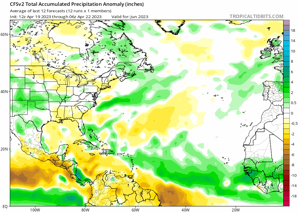
cycloneye wrote:Early season activity followed by El NIño effects is the look of this.
https://twitter.com/dmorris9661/status/1649732566327386113
Something I've noticed is many of these precip model maps for peak season seem to suggest an increased risk for the Florida Peninsula. Especially around the August/September timeframe, where you can clearly see a potential track path with precip bands extending from just north of the Greater Antilles all the way to Florida.
0 likes
Unless explicitly stated, all information in my posts is based on my own opinions and observations. Tropical storms and hurricanes can be extremely dangerous. Refer to an accredited weather research agency or meteorologist if you need to make serious decisions regarding an approaching storm.

-
SFLcane

- S2K Supporter

- Posts: 10281
- Age: 48
- Joined: Sat Jun 05, 2010 1:44 pm
- Location: Lake Worth Florida
Re: 2023 Indicators (SST, SAL, MSLP, Wind shear, Steering, Instability) and Day 16+ Models
Busy early season with all the + ssta.
1 likes
-
Yellow Evan

- Professional-Met

- Posts: 16257
- Age: 27
- Joined: Fri Jul 15, 2011 12:48 pm
- Location: Henderson, Nevada/Honolulu, HI
- Contact:
Re: 2023 Indicators (SST, SAL, MSLP, Wind shear, Steering, Instability) and Day 16+ Models
2 likes
-
Category5Kaiju
- Category 5
- Posts: 4345
- Joined: Thu Dec 24, 2020 12:45 pm
- Location: Seattle during the summer, Phoenix during the winter
Re: 2023 Indicators (SST, SAL, MSLP, Wind shear, Steering, Instability) and Day 16+ Models
Yeah, it also kind of makes sense if the Caribbean is going to be unfavorable. Storm activity will likely be north of that region, and all it takes is a decently strong ridge at the right time during late August or September to potentially cause trouble. If you live in the East Coast of Florida, stay vigilant! Hopefully Florida ends up lucky this season
0 likes
Unless explicitly stated, all information in my posts is based on my own opinions and observations. Tropical storms and hurricanes can be extremely dangerous. Refer to an accredited weather research agency or meteorologist if you need to make serious decisions regarding an approaching storm.
-
SFLcane
- S2K Supporter
- Posts: 10281
- Age: 48
- Joined: Sat Jun 05, 2010 1:44 pm
- Location: Lake Worth Florida
Re: 2023 Indicators (SST, SAL, MSLP, Wind shear, Steering, Instability) and Day 16+ Models
Yellow Evan wrote::uarrow: Not if the WAM is so poleward and active that everything coming off of it is monsoonal slop. This has been a major hindrance towards early season activity most recent years.
All you need is a favorable window whether it’s in the western part of the basin or somewhere else that’s impossible to predict. I really believe the first part of the season will El Niño affects lagging behind a bit could be busy. Major hurricanes lately as usual tend to wait till close to land to explode so always have to watch for that. Numbers mean crap all it takes is 1 over you.
0 likes
-
Yellow Evan
- Professional-Met
- Posts: 16257
- Age: 27
- Joined: Fri Jul 15, 2011 12:48 pm
- Location: Henderson, Nevada/Honolulu, HI
- Contact:
Re: 2023 Indicators (SST, SAL, MSLP, Wind shear, Steering, Instability) and Day 16+ Models
SFLcane wrote:Yellow Evan wrote::uarrow: Not if the WAM is so poleward and active that everything coming off of it is monsoonal slop. This has been a major hindrance towards early season activity most recent years.
All you need is a favorable window whether it’s in the western part of the basin or somewhere else that’s impossible to predict. I really believe the first part of the season will El Niño affects lagging behind a bit could be busy. Major hurricanes lately as usual tend to wait till close to land to explode so always have to watch for that. Numbers mean crap all it takes is 1 over you.
What does most of this have to do with what I wrote? Even if the upper levels in the western portion of the basin is favorable, if disturbances rolling out structurally are not suited for TCG or at least TCG that doesn’t take days as been the case in recent years, it’s harder to imagine any significant systems happening. I think most people in this forum are well aware that in any season no matter how quiet any TC can be quite damaging.
3 likes
-
Yellow Evan
- Professional-Met
- Posts: 16257
- Age: 27
- Joined: Fri Jul 15, 2011 12:48 pm
- Location: Henderson, Nevada/Honolulu, HI
- Contact:
Re: 2023 Indicators (SST, SAL, MSLP, Wind shear, Steering, Instability) and Day 16+ Models
Category5Kaiju wrote:cycloneye wrote:Early season activity followed by El NIño effects is the look of this.
https://twitter.com/dmorris9661/status/1649732566327386113
Something I've noticed is many of these precip model maps for peak season seem to suggest an increased risk for the Florida Peninsula. Especially around the August/September timeframe, where you can clearly see a potential track path with precip bands extending from just north of the Greater Antilles all the way to Florida.
Are we sure that rainfall is TC induced?
0 likes
-
Kingsunited33
- Tropical Wave

- Posts: 2
- Joined: Thu Mar 16, 2023 8:50 pm
Re: 2023 Indicators (SST, SAL, MSLP, Wind shear, Steering, Instability) and Day 16+ Models
Yellow Evan wrote:SFLcane wrote:Yellow Evan wrote::uarrow: Not if the WAM is so poleward and active that everything coming off of it is monsoonal slop. This has been a major hindrance towards early season activity most recent years.
All you need is a favorable window whether it’s in the western part of the basin or somewhere else that’s impossible to predict. I really believe the first part of the season will El Niño affects lagging behind a bit could be busy. Major hurricanes lately as usual tend to wait till close to land to explode so always have to watch for that. Numbers mean crap all it takes is 1 over you.
What does most of this have to do with what I wrote? Even if the upper levels in the western portion of the basin is favorable, if disturbances rolling out structurally are not suited for TCG or at least TCG that doesn’t take days as been the case in recent years, it’s harder to imagine any significant systems happening. I think most people in this forum are well aware that in any season no matter how quiet any TC can be quite damaging.
I don't think it's relevant in this case because we may have one of the most favorable Atlantic setups we've seen for an El Niño year in a long time. I also doubt the WAM will be that strong this season as well. It's becoming more and more likely that we are going to see something unique occur during this season compared to the last decade.
2 likes
-
Yellow Evan
- Professional-Met
- Posts: 16257
- Age: 27
- Joined: Fri Jul 15, 2011 12:48 pm
- Location: Henderson, Nevada/Honolulu, HI
- Contact:
Re: 2023 Indicators (SST, SAL, MSLP, Wind shear, Steering, Instability) and Day 16+ Models
Kingsunited33 wrote:Yellow Evan wrote:SFLcane wrote:
All you need is a favorable window whether it’s in the western part of the basin or somewhere else that’s impossible to predict. I really believe the first part of the season will El Niño affects lagging behind a bit could be busy. Major hurricanes lately as usual tend to wait till close to land to explode so always have to watch for that. Numbers mean crap all it takes is 1 over you.
What does most of this have to do with what I wrote? Even if the upper levels in the western portion of the basin is favorable, if disturbances rolling out structurally are not suited for TCG or at least TCG that doesn’t take days as been the case in recent years, it’s harder to imagine any significant systems happening. I think most people in this forum are well aware that in any season no matter how quiet any TC can be quite damaging.
I don't think it's relevant in this case because we may have one of the most favorable Atlantic setups we've seen for an El Niño year in a long time. I also doubt the WAM will be that strong this season as well. It's becoming more and more likely that we are going to see something unique occur during this season compared to the last decade.
See this is sorta a two way street. A quite WAM means less rising motion over Africa, which would lead to stronger trades over the MDR and thus worse SSTA. Otherwise, we’re set up for a mid to late 60s style repeat where the AMO configuration would fall off during the summer and amplify during the winter due to -NAO.
https://twitter.com/cyclonicwx/status/1424728302338641922
0 likes


Re: 2023 Indicators (SST, SAL, MSLP, Wind shear, Steering, Instability) and Day 16+ Models
In the modern era, the set of analogs to maybe start looking at are the -PDO nestled events that are first year El Ninos following multiple cold ENSO events. 1972, 1976, 1986, 2002, 2009, and 2014 as a start.
ACE for these years range from 35 to 84 so none break 90 units. Average sets below normal for this metric. I would guess an early range of ~40-60 units for the season using this data. Going even further back I don't think there is an El Nino of the similar sequence that produced greater than 100 ACE except 1951. The bigger ACE Nino seasons tends to occur later in the stages of +PDO (Ninos following other Ninos within a greater +PDO regime.)
ACE for these years range from 35 to 84 so none break 90 units. Average sets below normal for this metric. I would guess an early range of ~40-60 units for the season using this data. Going even further back I don't think there is an El Nino of the similar sequence that produced greater than 100 ACE except 1951. The bigger ACE Nino seasons tends to occur later in the stages of +PDO (Ninos following other Ninos within a greater +PDO regime.)
1 likes
The above post and any post by Ntxw is NOT an official forecast and should not be used as such. It is just the opinion of the poster and may or may not be backed by sound meteorological data. It is NOT endorsed by any professional institution including Storm2k. For official information, please refer to NWS products.
Help support Storm2K!
-
Yellow Evan
- Professional-Met
- Posts: 16257
- Age: 27
- Joined: Fri Jul 15, 2011 12:48 pm
- Location: Henderson, Nevada/Honolulu, HI
- Contact:
Re: 2023 Indicators (SST, SAL, MSLP, Wind shear, Steering, Instability) and Day 16+ Models
Ntxw wrote:In the modern era, the set of analogs to maybe start looking at are the -PDO nestled events that are first year El Ninos following multiple cold ENSO events. 1972, 1976, 1986, 2002, 2009, and 2014 as a start.
ACE for these years range from 35 to 84 so none break 90 units. Average sets below normal for this metric. I would guess an early range of ~40-60 units for the season using this data. Going even further back I don't think there is an El Nino of the similar sequence that produced greater than 100 ACE except 1951. The bigger ACE Nino seasons tends to occur later in the stages of +PDO (Nino's following other Ninos within a greater +PDO regime.)
Since when is 1986 and 2014 -PDO?
0 likes
Re: 2023 Indicators (SST, SAL, MSLP, Wind shear, Steering, Instability) and Day 16+ Models
Yellow Evan wrote:Ntxw wrote:In the modern era, the set of analogs to maybe start looking at are the -PDO nestled events that are first year El Ninos following multiple cold ENSO events. 1972, 1976, 1986, 2002, 2009, and 2014 as a start.
ACE for these years range from 35 to 84 so none break 90 units. Average sets below normal for this metric. I would guess an early range of ~40-60 units for the season using this data. Going even further back I don't think there is an El Nino of the similar sequence that produced greater than 100 ACE except 1951. The bigger ACE Nino seasons tends to occur later in the stages of +PDO (Nino's following other Ninos within a greater +PDO regime.)
Since when is 1986 and 2014 -PDO?
They are within transition periods following cold ENSO events. You can take them out and still get similar results.
0 likes
The above post and any post by Ntxw is NOT an official forecast and should not be used as such. It is just the opinion of the poster and may or may not be backed by sound meteorological data. It is NOT endorsed by any professional institution including Storm2k. For official information, please refer to NWS products.
Help support Storm2K!
Help support Storm2K!
-
dexterlabio
- Category 5
- Posts: 3517
- Joined: Sat Oct 24, 2009 11:50 pm
Re: 2023 Indicators (SST, SAL, MSLP, Wind shear, Steering, Instability) and Day 16+ Models
Ntxw wrote:Yellow Evan wrote:Ntxw wrote:In the modern era, the set of analogs to maybe start looking at are the -PDO nestled events that are first year El Ninos following multiple cold ENSO events. 1972, 1976, 1986, 2002, 2009, and 2014 as a start.
ACE for these years range from 35 to 84 so none break 90 units. Average sets below normal for this metric. I would guess an early range of ~40-60 units for the season using this data. Going even further back I don't think there is an El Nino of the similar sequence that produced greater than 100 ACE except 1951. The bigger ACE Nino seasons tends to occur later in the stages of +PDO (Nino's following other Ninos within a greater +PDO regime.)
Since when is 1986 and 2014 -PDO?
They are within transition periods following cold ENSO events. You can take them out and still get similar results.
I recall when the first signs showed up that an El Niño was coming in 2014 many of us were skeptical because of the solid -PDO then.
0 likes
Personal Forecast Disclaimer:
The posts in this forum are NOT official forecast and should not be used as such. They are just the opinion of the poster and may or may not be backed by sound meteorological data. They are NOT endorsed by any professional institution or storm2k.org. For official information, please refer to the NHC and NWS products.
The posts in this forum are NOT official forecast and should not be used as such. They are just the opinion of the poster and may or may not be backed by sound meteorological data. They are NOT endorsed by any professional institution or storm2k.org. For official information, please refer to the NHC and NWS products.
-
DorkyMcDorkface

- Category 5
- Posts: 1042
- Age: 28
- Joined: Mon Sep 30, 2019 1:32 pm
- Location: Mid-Atlantic
Re: 2023 Indicators (SST, SAL, MSLP, Wind shear, Steering, Instability) and Day 16+ Models
Ntxw wrote:In the modern era, the set of analogs to maybe start looking at are the -PDO nestled events that are first year El Ninos following multiple cold ENSO events. 1972, 1976, 1986, 2002, 2009, and 2014 as a start.
ACE for these years range from 35 to 84 so none break 90 units. Average sets below normal for this metric. I would guess an early range of ~40-60 units for the season using this data. Going even further back I don't think there is an El Nino of the similar sequence that produced greater than 100 ACE except 1951. The bigger ACE Nino seasons tends to occur later in the stages of +PDO (Ninos following other Ninos within a greater +PDO regime.)
I get where you're getting at and I would expect ACE to be somewhere in that range if we didn't have the caveat of a warm tropical Atlantic, and there is also whether or not we get another strong WAM episode generated by the African Standing Wave which could be prevalent enough to offset some Niño effects. Those years you've listed did not have either of those despite having similar ENSO evolution. But I don't know how effective that would be if the Niño gets into, say, strong territory, so that remains to be seen. Right now I do still think the season will be below average mind you, but at the same time I think the ACE ceiling has the potential to be higher maybe, but not too high (75-80 max might be a good bet).
(editing this because I realized I used the incorrect data set, oops)


Last edited by DorkyMcDorkface on Sun Apr 23, 2023 2:08 pm, edited 3 times in total.
1 likes
Please note the thoughts expressed by this account are solely those of the user and are from a hobbyist perspective. For more comprehensive analysis, consult an actual professional meteorologist or meteorological agency.
Floyd 1999 | Isabel 2003 | Hanna 2008 | Irene 2011 | Sandy 2012 | Isaias 2020
Re: 2023 Indicators (SST, SAL, MSLP, Wind shear, Steering, Instability) and Day 16+ Models
DorkyMcDorkface wrote:Ntxw wrote:In the modern era, the set of analogs to maybe start looking at are the -PDO nestled events that are first year El Ninos following multiple cold ENSO events. 1972, 1976, 1986, 2002, 2009, and 2014 as a start.
ACE for these years range from 35 to 84 so none break 90 units. Average sets below normal for this metric. I would guess an early range of ~40-60 units for the season using this data. Going even further back I don't think there is an El Nino of the similar sequence that produced greater than 100 ACE except 1951. The bigger ACE Nino seasons tends to occur later in the stages of +PDO (Ninos following other Ninos within a greater +PDO regime.)
I get where you're getting at and I would expect ACE to be somewhere in that range if we didn't have the caveat of a warm tropical Atlantic, and there is also whether or not we get another strong WAM episode generated by the African Standing Wave which could be prevalent enough to offset some Niño effects. Those years you've listed did not have either of those despite having similar ENSO evolution. But I don't know how effective that would be if the Niño gets into, say, strong territory, so that remains to be seen. Right now I do still think the season will be below average mind you, but at the same time I think the ACE ceiling has the potential to be higher maybe, but not too high (75-80 max might be a good bet).
https://i.ibb.co/C8sJVbr/Ziopc2gl-Ee.png
https://i.ibb.co/tLf60Tq/pbbqv-Ha8t-L.png
Thanks for your input! I only listed using metric of ENSO and indirectly PDO as a starting guide. Not including anything else, you can add those features in but then it becomes much broader and you can get all sorts of outcomes. That doesn't narrow the guess. At that point one can say it may be below normal, near normal, or above normal which doesn't help when trying to make an educated guess
2 likes
The above post and any post by Ntxw is NOT an official forecast and should not be used as such. It is just the opinion of the poster and may or may not be backed by sound meteorological data. It is NOT endorsed by any professional institution including Storm2k. For official information, please refer to NWS products.
Help support Storm2K!
Help support Storm2K!
-
DorkyMcDorkface
- Category 5
- Posts: 1042
- Age: 28
- Joined: Mon Sep 30, 2019 1:32 pm
- Location: Mid-Atlantic
Re: 2023 Indicators (SST, SAL, MSLP, Wind shear, Steering, Instability) and Day 16+ Models
Ntxw wrote:DorkyMcDorkface wrote:Ntxw wrote:In the modern era, the set of analogs to maybe start looking at are the -PDO nestled events that are first year El Ninos following multiple cold ENSO events. 1972, 1976, 1986, 2002, 2009, and 2014 as a start.
ACE for these years range from 35 to 84 so none break 90 units. Average sets below normal for this metric. I would guess an early range of ~40-60 units for the season using this data. Going even further back I don't think there is an El Nino of the similar sequence that produced greater than 100 ACE except 1951. The bigger ACE Nino seasons tends to occur later in the stages of +PDO (Ninos following other Ninos within a greater +PDO regime.)
I get where you're getting at and I would expect ACE to be somewhere in that range if we didn't have the caveat of a warm tropical Atlantic, and there is also whether or not we get another strong WAM episode generated by the African Standing Wave which could be prevalent enough to offset some Niño effects. Those years you've listed did not have either of those despite having similar ENSO evolution. But I don't know how effective that would be if the Niño gets into, say, strong territory, so that remains to be seen. Right now I do still think the season will be below average mind you, but at the same time I think the ACE ceiling has the potential to be higher maybe, but not too high (75-80 max might be a good bet).
https://i.ibb.co/C8sJVbr/Ziopc2gl-Ee.png
https://i.ibb.co/tLf60Tq/pbbqv-Ha8t-L.png
Thanks for your input! I only listed using metric of ENSO and indirectly PDO as a starting guide. Not including anything else, you can add those features in but then it becomes much broader and you can get all sorts of outcomes. That doesn't narrow the guess. At that point one can say it may be below normal, near normal, or above normal which doesn't help when trying to make an educated guess.
Yeah I understand, was just thinking about some other potential factors.
0 likes
Please note the thoughts expressed by this account are solely those of the user and are from a hobbyist perspective. For more comprehensive analysis, consult an actual professional meteorologist or meteorological agency.
Floyd 1999 | Isabel 2003 | Hanna 2008 | Irene 2011 | Sandy 2012 | Isaias 2020
Who is online
Users browsing this forum: Google Adsense [Bot], Iceresistance and 158 guests