
Tropical Wave in Bay of Campeche (Is Invest 91L)
Moderator: S2k Moderators
Forum rules

The posts in this forum are NOT official forecasts and should not be used as such. They are just the opinion of the poster and may or may not be backed by sound meteorological data. They are NOT endorsed by any professional institution or STORM2K. For official information, please refer to products from the National Hurricane Center and National Weather Service.
Re: Tropical Wave in Central Atlantic (0/40)
0 likes
TC naming lists: retirements and intensity
Most aggressive Advisory #1's in North Atlantic (cr. kevin for starting the list)
Most aggressive Advisory #1's in North Atlantic (cr. kevin for starting the list)


Re: Tropical Wave in Central Atlantic (0/40)
jlauderdal wrote:SFLcane wrote:358
ABNT20 KNHC 291133
TWOAT
Tropical Weather Outlook
NWS National Hurricane Center Miami FL
800 AM EDT Thu Aug 29 2024
For the North Atlantic...Caribbean Sea and the Gulf of Mexico:
Central Tropical Atlantic:
A tropical wave over the central Tropical Atlantic Ocean is
producing some disorganized showers and thunderstorms. Environmental
conditions appear conducive for gradual development of this system,
and a tropical depression could form by early next week while it
moves westward at 10 to 15 mph and approaches the Lesser Antilles.
The system is then forecast to move westward to west-northwestward
across portions of the eastern Caribbean Sea during the middle part
of next week.
* Formation chance through 48 hours...low...near 0 percent.
* Formation chance through 7 days...medium...40 percent.
$$
Forecaster Reinhart
That is a solid move by NHC; they like what they are seeing.
Or rather, they don't like what they're seeing.
But I get what you're saying.
4 likes
-
Category5Kaiju

- Category 5

- Posts: 4347
- Joined: Thu Dec 24, 2020 12:45 pm
- Location: Seattle during the summer, Phoenix during the winter
Re: Tropical Wave in Central Atlantic (0/40)
Wow, this one imho is certainly going to be one to watch. Looks like the meat of the season may be just upon us.
3 likes
Unless explicitly stated, all information in my posts is based on my own opinions and observations. Tropical storms and hurricanes can be extremely dangerous. Refer to an accredited weather research agency or meteorologist if you need to make serious decisions regarding an approaching storm.
Re: Tropical Wave in Central Atlantic (0/40)
6z ECMWF at 87 hrs has the vorticity even more organized than the 0z run.
I'm also updating the ensemble member counts for posterity. Usual caveats that some of them may not be bonafide TCs, as Ubuntwo elaborated here.
GEFS member low pressure counts (±2, out of 31):
I'm also updating the ensemble member counts for posterity. Usual caveats that some of them may not be bonafide TCs, as Ubuntwo elaborated here.
GEFS member low pressure counts (±2, out of 31):
- 6z 8/29: 12 (39%) as of Eastern Caribbean (a few members start in WCar)
- 0z 8/29: 11 (35%) as of Eastern Caribbean (a few members start in WCar)
- 18z 8/28: 13 (42%) as of Eastern Caribbean
- 12z 8/28: 7 (23%) as of Eastern Caribbean (a few members start in WCar, but unsure if they're from this wave or a CAG)
- 6z 8/28: 9 (29%)
- 0z 8/28: 9 (29%)
- 18z 8/27: 4 (13%)
- 12z 8/27: 9 (29%)
- 6z 8/27: 14 (45%)
- 0z 8/27: 9 (29%)
- 18z 8/26: 19 (61%)
- 12z 8/26: 17 (55%)
- 6z 8/26: 19 (61%)
- 0z 8/26: 16 (52%)
- 18z 8/25: 10 (32%)
- 12z 8/25: 14 (45%)
- 6z 8/29 (out to 144 hrs only): 30 (59%, some may not be TCs)
- 0z 8/29: 29 (57%) as of Eastern Caribbean
- 18z 8/28 (out to 144 hrs only): 33 (65%, some may not be TCs)
- 12z 8/28: 18 (35%) as of Eastern Caribbean (a few members dissipate there, a few develop in WCar)
- 6z 8/28 (out to 144 hrs only): 21 (41%, some may not be TCs)
- 0z 8/28: 11 (22%)
- 18z 8/27 (out to 144 hrs only): 15 (29%)
- 12z 8/27: 14 (27%)
- 6z 8/27 (out to 144 hrs only): 20 (39%)
- 0z 8/27: 25 (49%)
- 18z 8/26 (out to 144 hrs only): 27 (53%)
- 12z 8/26: 34 (67%)
- 0z 8/26: 22 (43%)
- 12z 8/25: 11 (22%)
3 likes
TC naming lists: retirements and intensity
Most aggressive Advisory #1's in North Atlantic (cr. kevin for starting the list)
Most aggressive Advisory #1's in North Atlantic (cr. kevin for starting the list)

Re: Tropical Wave in Central Atlantic (0/40)
Last 4 Euro-AI have this go across Yucatan, Bay of Campeche, and back into MX for final landfall.
If we were already in a moderate to strong La Niña (per RONI), I’d favor the Euro-AI more. But with it being only weak, I’m hesitant to bet on this far S track as weak Niña tend to have further N tracks. Of course, these are merely generalities and thus any one storm is still going to be all over the map as far as possible tracks.
If we were already in a moderate to strong La Niña (per RONI), I’d favor the Euro-AI more. But with it being only weak, I’m hesitant to bet on this far S track as weak Niña tend to have further N tracks. Of course, these are merely generalities and thus any one storm is still going to be all over the map as far as possible tracks.
0 likes
Personal Forecast Disclaimer:
The posts in this forum are NOT official forecasts and should not be used as such. They are just the opinion of the poster and may or may not be backed by sound meteorological data. They are NOT endorsed by any professional institution or storm2k.org. For official information, please refer to the NHC and NWS products.
The posts in this forum are NOT official forecasts and should not be used as such. They are just the opinion of the poster and may or may not be backed by sound meteorological data. They are NOT endorsed by any professional institution or storm2k.org. For official information, please refer to the NHC and NWS products.
-
skyline385

- Category 5
- Posts: 2728
- Age: 35
- Joined: Wed Aug 26, 2020 11:15 pm
- Location: Houston TX


Re: Tropical Wave in Central Atlantic (0/40)
If this tracks south of the islands, as several of the models seem to be leaning towards, then a second long-tracking Caribbean Cruiser major isn’t out of the question. Almost the entire Caribbean is around 30C. Quite a high ceiling assuming the system can put itself together.
1 likes
Irene '11 Sandy '12 Hermine '16 5/15/2018 Derecho Fay '20 Isaias '20 Elsa '21 Henri '21 Ida '21
I am only a meteorology enthusiast who knows a decent amount about tropical cyclones. Look to the professional mets, the NHC, or your local weather office for the best information.
I am only a meteorology enthusiast who knows a decent amount about tropical cyclones. Look to the professional mets, the NHC, or your local weather office for the best information.
-
wxman57

- Moderator-Pro Met

- Posts: 23175
- Age: 68
- Joined: Sat Jun 21, 2003 8:06 pm
- Location: Houston, TX (southwest)
Re: Tropical Wave in Central Atlantic (0/40)
I'm hoping it doesn't develop, but I think there's a good chance it will. Currently don't see anything to push it toward the NW Gulf, at least. Could eventually become a Florida threat. We'll see. I'm still taking tomorrow off and will be off until Tuesday (I hope).
8 likes
-
SFLcane

- S2K Supporter

- Posts: 10281
- Age: 48
- Joined: Sat Jun 05, 2010 1:44 pm
- Location: Lake Worth Florida
Re: Tropical Wave in Central Atlantic (0/40)
Icon undergoing RI south of PR only goes to 18hrs at 12z but i bet it would have should a major if it went out further
0 likes
-
SFLcane
- S2K Supporter
- Posts: 10281
- Age: 48
- Joined: Sat Jun 05, 2010 1:44 pm
- Location: Lake Worth Florida
Re: Tropical Wave in Central Atlantic (0/40)
wxman57 wrote:I'm hoping it doesn't develop, but I think there's a good chance it will. Currently don't see anything to push it toward the NW Gulf, at least. Could eventually become a Florida threat. We'll see. I'm still taking tomorrow off and will be off until Tuesday (I hope).

0 likes
-
SFLcane
- S2K Supporter
- Posts: 10281
- Age: 48
- Joined: Sat Jun 05, 2010 1:44 pm
- Location: Lake Worth Florida
Re: Tropical Wave in Central Atlantic (0/40)
wxman57 whats your take on a 64 Cleo analog for this AOI?
0 likes

Re: Tropical Wave in Central Atlantic (0/40)
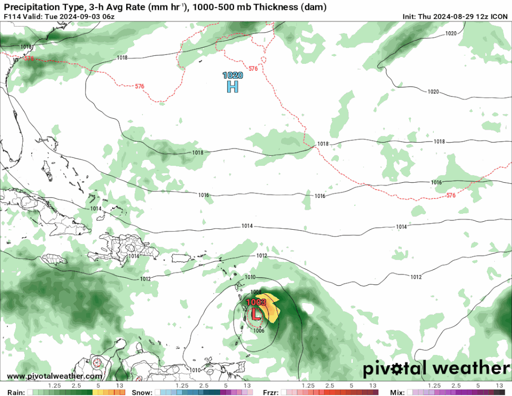
12z ICON @180 hrs, 970 mb. Farther east than 06z GFS.

0 likes
-
toad strangler

- S2K Supporter
- Posts: 4546
- Joined: Sun Jul 28, 2013 3:09 pm
- Location: Earth
- Contact:
Re: Tropical Wave in Central Atlantic (0/40)
aspen wrote:If this tracks south of the islands, as several of the models seem to be leaning towards, then a second long-tracking Caribbean Cruiser major isn’t out of the question. Almost the entire Caribbean is around 30C. Quite a high ceiling assuming the system can put itself together.
IRT to aspen’s point
https://twitter.com/drkimwood/status/1829165001774678490
0 likes
My Weather Station
https://www.wunderground.com/dashboard/pws/KFLPORTS603
https://www.wunderground.com/dashboard/pws/KFLPORTS603
Re: Tropical Wave in Central Atlantic (0/40)
aspen wrote:If this tracks south of the islands, as several of the models seem to be leaning towards, then a second long-tracking Caribbean Cruiser major isn’t out of the question. Almost the entire Caribbean is around 30C. Quite a high ceiling assuming the system can put itself together.
On the other hand, a track north of Greater Antilles -- as some GEFS and EPS members are still suggesting -- can still result in a major generating a lot of ACE as it recurves, though that definitely seems much less likely now as most models are trending south. Land interaction is really the key here in terms of how strong it gets and how long it lasts (assuming it develops).
0 likes
TC naming lists: retirements and intensity
Most aggressive Advisory #1's in North Atlantic (cr. kevin for starting the list)
Most aggressive Advisory #1's in North Atlantic (cr. kevin for starting the list)
-
Category5Kaiju
- Category 5
- Posts: 4347
- Joined: Thu Dec 24, 2020 12:45 pm
- Location: Seattle during the summer, Phoenix during the winter
Re: Tropical Wave in Central Atlantic (0/40)
It’s honestly quite fascinating that we’re talking about the possibility of multiple Caribbean cruisers; that’s not something many hurricane seasons have seen (last time this happened was 2007 with Dean and Felix) 
2 likes
Unless explicitly stated, all information in my posts is based on my own opinions and observations. Tropical storms and hurricanes can be extremely dangerous. Refer to an accredited weather research agency or meteorologist if you need to make serious decisions regarding an approaching storm.
-
Cachondo23
- Tropical Storm

- Posts: 131
- Joined: Wed May 25, 2022 5:56 am
Re: Tropical Wave in Central Atlantic (0/40)
Do we currently have a strong High Pressure therefore almost every model keep it going west?
0 likes
-
SFLcane
- S2K Supporter
- Posts: 10281
- Age: 48
- Joined: Sat Jun 05, 2010 1:44 pm
- Location: Lake Worth Florida
Re: Tropical Wave in Central Atlantic (0/40)
Cachondo23 wrote:Do we currently have a strong High Pressure therefore almost every model keep it going west?
0 likes
Who is online
Users browsing this forum: No registered users and 176 guests